All Activity
- Past hour
-

January 2026 regional war/obs/disco thread
WinterWolf replied to Baroclinic Zone's topic in New England
Agreed…. -

January 2026 regional war/obs/disco thread
Damage In Tolland replied to Baroclinic Zone's topic in New England
One thing to note is we’ve had a fast PAC flow since early autumn. And one coastal Noreaster in fall. No one should be or have been expecting coastals this winter. You like to see a bunch in fall to set precedent . Fast flows do not deliver big east coast coastals -
Sounds fun! We will be expecting some pictures.
-

January 2026 regional war/obs/disco thread
dendrite replied to Baroclinic Zone's topic in New England
I like mine to be critters that bite. -

12/31-1/1 Possible Snow Showers/Squalls to Start 2026
nj2va replied to bncho's topic in Mid Atlantic
I haven’t been diligent this time especially with the wind making measuring almost impossible. Wisp is reporting 3” overnight so I’ll just go with that. I’ll try to measure tonight/tomorrow’s storm so you can keep your tally going. LWX point and click says 1-3” today and 5-9” tonight - it feels like we’ll end up on the higher end of those ranges based on how this first wave over performed. The lift is impressive on the models and the trajectory of the wave will really enhance upslope — that coupled with the ratios of upper teens/low 20s:1 and I’m excited for tonight. Hope your chase is epic! -

January 2026 regional war/obs/disco thread
tamarack replied to Baroclinic Zone's topic in New England
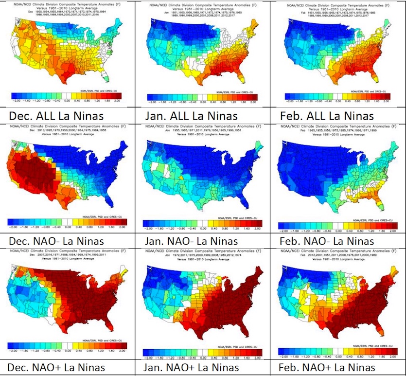
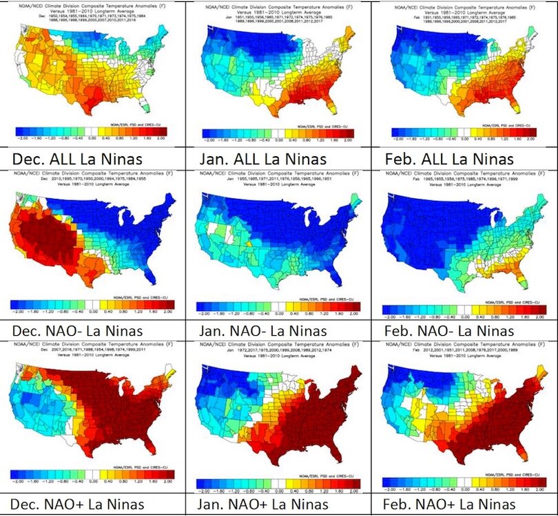
Depending how close to 2.0/winter, you're doing better than here considering our considerably greater average snowfall, currently 88.5" thru 27 full seasons. We've had 47 storms of 10"+ in those 27 winters, or 1.7 per. Maybe we do better on 20"+, currently 8 plus 19.9 in March 2018. Early January looks cold (~8-10° BN) and dry. Maybe, like December, it can be BN for precip but AN for snow (22.4" vs 19.3" avg). -
I went back and looped the radar and that band really blossomed right overhead. Based on the returns it would have been coming down moderately. It then weakened as it moved east. I was in exactly the right spot lol.
-

Pittsburgh/Western PA WINTER ‘25/‘26
TheClimateChanger replied to Burghblizz's topic in Upstate New York/Pennsylvania
Solid start. I'm probably closing in on an additional inch. Grass is completely covered now. -
January 2026 regional war/obs/disco thread
WinterWolf replied to Baroclinic Zone's topic in New England
No, I understood. Clippers are everywhere this year…after a big hiatus. -

-
Pittsburgh/Western PA WINTER ‘25/‘26
TheClimateChanger replied to Burghblizz's topic in Upstate New York/Pennsylvania
That's our bread and butter. Although I'm gonna have to call foul on the airport (actually the NWS office in Moon) being moved 20 miles south, since it already did better than probably 75-80% of the area with the last event. It doesn't need to be the jackpot for every event. -

Pittsburgh/Western PA WINTER ‘25/‘26
Burghblizz replied to Burghblizz's topic in Upstate New York/Pennsylvania
I think an inch or two is possible with this appetizer batch, especially north of the city. Not the heaviest snow, but it’s steady and very fluffy. -
That is a legit concern for me, too. The forecasted -EPO/+TNH cold pattern for the central US eventually looks great for cold domination prospects for the central US, much of the Midwest, and the N NE. But the biggest risk against sustainable cold is in the SE primarily and Mid-Atlantic secondarily, where the SE ridge may be too strong if the PNA in the means doesn’t go positive. This is very difficult to forecast this far out. Although I don’t like the warmer model developments of recent days for week 2 in the E US, my hope is still that the PNA in the means will flip for Jan averaged out to match the 100% of -ENSO -PNA Decs since 1983-4 that went to a net +PNA for Jan. My other hope is that the 90 day -PNA bias of the GEFS/EPS/GEPS means that they’re currently off. The GEFS AO looks better for midmonth vs yesterday fwiw.
-
Given the -NAO, we would have to really be cursed not to get any cold air in Jan. Linking up the moisture with the cold is of course another matter
-

January 2026 regional war/obs/disco thread
WxWatcher007 replied to Baroclinic Zone's topic in New England
To be clear, not saying a KU is coming lol -
January 2026 regional war/obs/disco thread
WxWatcher007 replied to Baroclinic Zone's topic in New England
I kind of am tbh. That’s been the trend. Thinking there’s light snows Sunday and maybe with the follow up after. Clippers are back… -
January 2026 regional war/obs/disco thread
dendrite replied to Baroclinic Zone's topic in New England
It needs a lot of work and I don’t think there’s enough time. I think the northern stream is the turd in the punchbowl. We’d (you’d) probably be better off with it out of the picture so the southern stream could amplify more on its own. It probably wouldn’t help up here, but maybe there would be time in SNE. -
Me too.
-

12/31-1/1 Possible Snow Showers/Squalls to Start 2026
T. August replied to bncho's topic in Mid Atlantic
Micro dusting. Congrats @CAPE! -

Central PA Winter 25/26 Discussion and Obs
mahantango#1 replied to MAG5035's topic in Upstate New York/Pennsylvania
As we close out this year, a lot of us didn't get the weather we wanted. Let's hope this coming year brings a snowstorm. With 2 to 3 feet of dry powdery snow with 40mph plus winds for 3 consecutive days. I'm sure a lot on here will be happy with that. Then we can move forward to Spring, and satisfy our warm weather friends. -
I’m enjoying the current cold and dry snap. I had two great walks in the Canadian air the last 2 days and expect another one today. The area got down into the high 20s for the low, not far from the 25 coldest so far. Keep in mind that as of just 10 days ago, this cold snap was nonexistent on the models! So, I consider it a bonus to enjoy.
-
Yep and he also followed up with this tweet…the +AO (aka “NAM”) and +NAO with SE ridge risk:
-

January 2026 regional war/obs/disco thread
Sey-Mour Snow replied to Baroclinic Zone's topic in New England
If 12z tics one more time like that it will get interesting, but I’m not expecting that. -
January 2026 regional war/obs/disco thread
WinterWolf replied to Baroclinic Zone's topic in New England
Someone always has to make it political. Sad. Especially on a weather forum. -
Great, Webb posted this yesterday on X: