All Activity
- Past hour
-

Invest 94L—80% 2 day and 90% seven day odds of development
wthrmn654 replied to WxWatcher007's topic in Tropical Headquarters


-

September 2025 OBS-Discussion centered NYC subforum
Brian5671 replied to wdrag's topic in New York City Metro
Humberto looks like a fish-maybe the other one into the Carolina's -
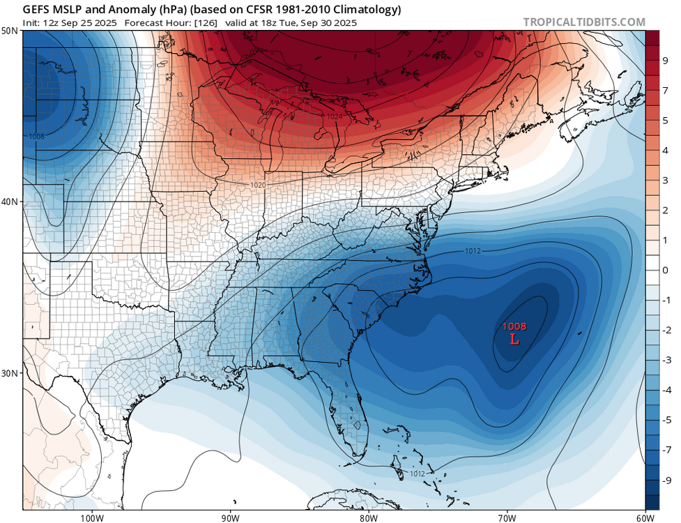
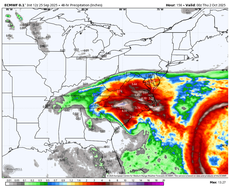
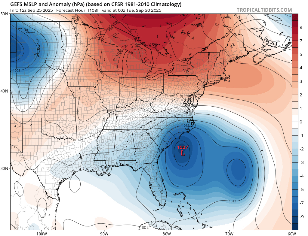
At 12Z EURO has Imelda to be hitting SC coast and then stalling out keeping heaviest rain south of DC. (48 hour precip totals for midweek.
-
 Yeah that's worst case in many ways, especially if it's a strong TS or weak hurricane lost at sea near the coast. Of course, this may be a nothingburger and we're all just b.s.'ing; let's not assume this will be a hurricane at any point, nevermind near NC/SC I'm suspicious of like 80% of the modeling beyond D4 at this point, but I'd expect a TS or weak 'cane approaching the Carolinas by then.
 -
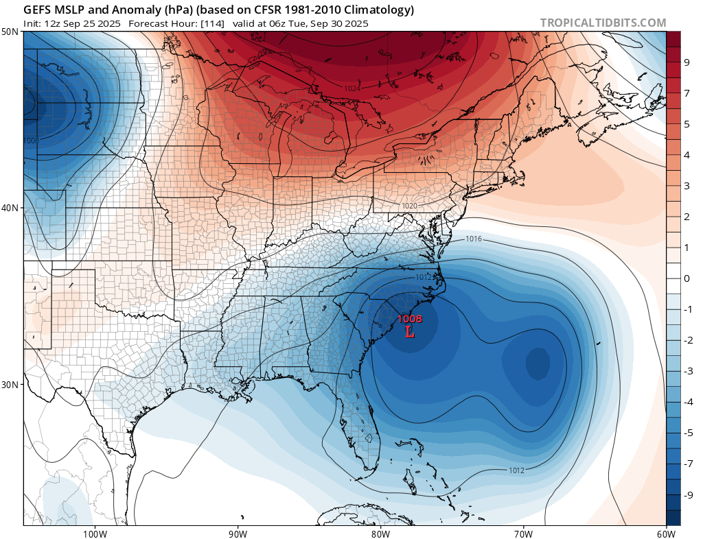
 12Z Euro is slower than 00Z... Landfall roughly the same area, but it is slower by about 6 hours....
 -
Invest 94L—80% 2 day and 90% seven day odds of development
wthrmn654 replied to WxWatcher007's topic in Tropical Headquarters
Gefs,imo doesn't look like much of anything and the storm kinda vanishes with the one to the east surviving going towards Bermuda... am I seeing it wrong or no? -
12z Euro into Wilmington, NC. Not much rain for the Saturday Night - Sunday morning deal but better trajectory for impacts from Imelda.
-

September 2025 OBS-Discussion centered NYC subforum
SACRUS replied to wdrag's topic in New York City Metro
Not sure how to direct link but wild tropicals tracking https://x.com/scweather_wx/status/1971206448223768645?s=46 -
September 2025 OBS-Discussion centered NYC subforum
SACRUS replied to wdrag's topic in New York City Metro
Up to 77 / 74 here. We'll see if we can get 80 - some more pronouced thinning clouds just west. -
I suspect even if we were to assume (which is a huge leap of faith) that these future climate model predictions were to come to pass....I suspect a change from an average annual temp of 56f (13c) degrees today warms by 4c as in the mid-Pilocene period to 63f (17c) would for folks in that area allow them to easily deal with your scary "unmanageable world" albeit with a longer growing season and less snow. The scam and hoax Trump speaks of are the very words and fear you trade in above. By using terms and images such as "consigned them to an unmanageable world" you are trying to scare folks into believing yet another in a long line of failed climate predictions. Again we are all still waiting for that firsts proven disaster that we can attribute to this scary climate change we keep hearing about.
-
 I never like to hear the word "stall" when talking about a hurricane approaching the NC/SC coast. That's always the most catastrophic scenario. Rain, rain, more rain.
 -
Not looking forward to next week.
-

September 2025 OBS-Discussion centered NYC subforum
winterwarlock replied to wdrag's topic in New York City Metro
.22 unimpressed -
Lol, 0.99" Sent from my SM-S921U using Tapatalk
-
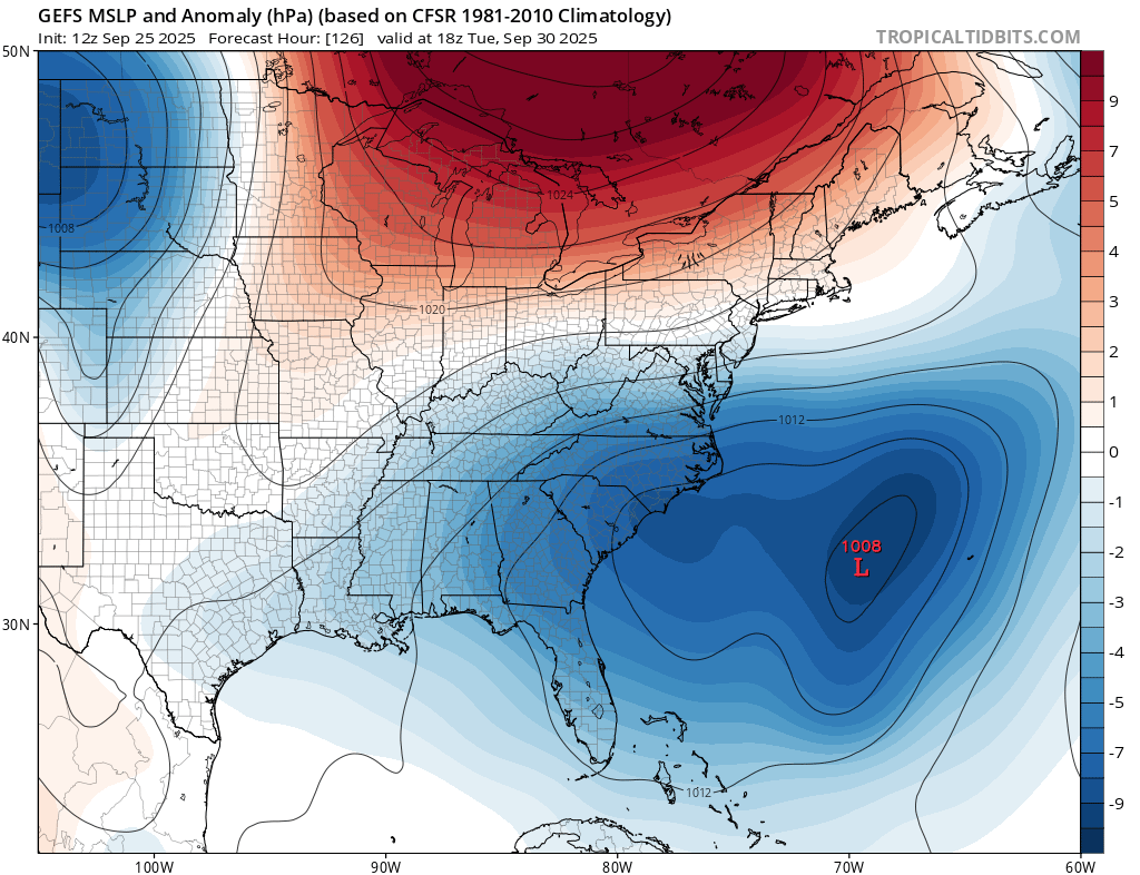
Euro AI does what I was going to mention as a possibilty earlier; stalls twice and even completes a small loop at some point? I think there is some validity to that, at least the entry point; either a very slow approach or full-on stall. Some of these modeled interactions are wild, and I'd toss.
-
Some great rains down this way today! Soccer practice got cancelled, bummed my son out as he was looking forward to running in the rain.
-

September 2025 OBS-Discussion centered NYC subforum
Stormlover74 replied to wdrag's topic in New York City Metro
18z euro is much drier. Everything is in far south jersey -

September 2025 OBS-Discussion centered NYC subforum
bluewave replied to wdrag's topic in New York City Metro
100° days have been arriving earlier in recent years making June 100° heat more common than late August into September. -
It’s always us, unless it’s Dec-March, and then it’s everyone else
-
Invest 94L—80% 2 day and 90% seven day odds of development
wthrmn654 replied to WxWatcher007's topic in Tropical Headquarters
Reminder, this link give you an interactive and interactive map of hurricane and invests, and can plot every single model run guidance wise. Can all be overlayed as well. The first product is one being referenced https://vlab.noaa.gov/web/osti-modeling/hfip/products -

Invest 94L—80% 2 day and 90% seven day odds of development
GaWx replied to WxWatcher007's topic in Tropical Headquarters
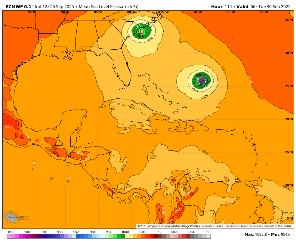
12Z Euro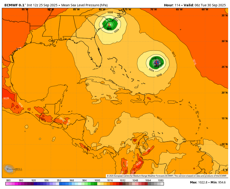
-
At 12Z AI has Imelda to be approaching SC coast and then swirls around and heads north brushing the coastal areas from Hatteras northward.
-

-
Invest 94L—80% 2 day and 90% seven day odds of development
GaWx replied to WxWatcher007's topic in Tropical Headquarters
Also, the UKMET, one of the top tier models, interacts with Humberto and goes well OTS from the SE US per my post above this. -
0-6km shear 40-50kt WNE/NYS. At least on SPC tab. Not too shabby.


(002).thumb.png.6e3d9d46bca5fe41aab7a74871dd8af8.png)