All Activity
- Past hour
-
What do you and others think about Nov 1950-March 1951 as an analogue for 2025-6? A well-known met. got on that train yesterday due to an anticipated active late tropical season having the potential to be similar to Oct of 1950 based on precip anomaly progs by the longer term Euro. This met. talked about the severe effects on the NE US caused by the 11/25/1950 superstorm.
-
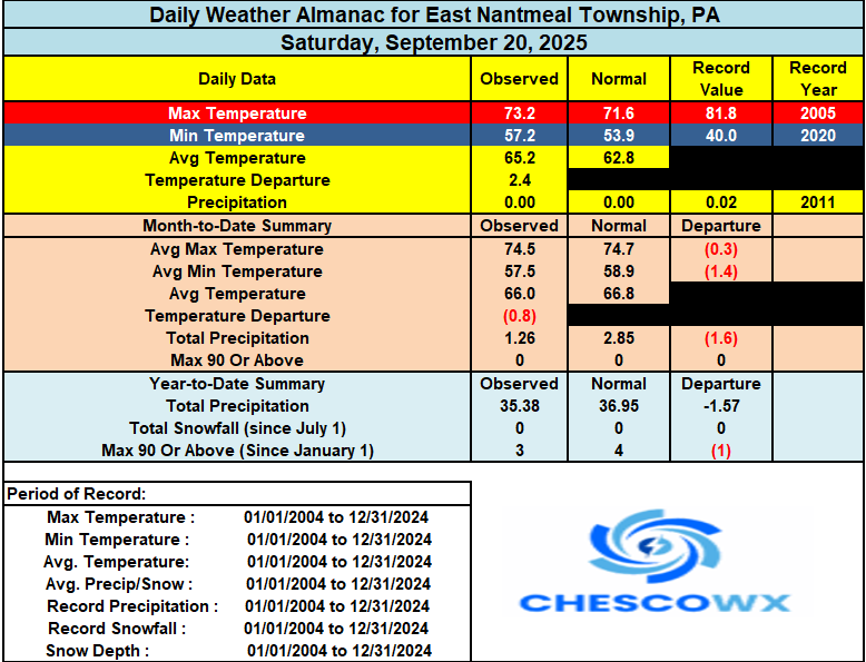
Similar temperatures to yesterday across the area with temperatures warming by Tuesday to well into the 70's to near 80 degrees. We then turn cooler for the rest of the week. The good news is our chances of rain are starting to increase by late Tuesday, and showers will be in the forecast for most of the rest of the week. Most models paint between 0.50" to 1.25" across the area. Let's hope this comes to pass.
-
(002).thumb.png.6e3d9d46bca5fe41aab7a74871dd8af8.png)
E PA/NJ/DE Autumn 2025 Obs/Discussion
ChescoWx replied to PhiEaglesfan712's topic in Philadelphia Region
Similar temperatures to yesterday across the area with temperatures warming by Tuesday to well into the 70's to near 80 degrees. We then turn cooler for the rest of the week. The good news is our chances of rain are starting to increase by late Tuesday, and showers will be in the forecast for most of the rest of the week. Most models paint between 0.50" to 1.25" across the area. Let's hope this comes to pass.
-

Occasional Thoughts on Climate Change
donsutherland1 replied to donsutherland1's topic in Climate Change
The heat in the West and Southwest are aided by ongoing aridification linked in recent research to the changes in the North Pacific. Summer: Annual:

-
We’ve known for years you are one of the longest growing seasons in New England. Just amazing how hard it is to drop there.
- Today
-
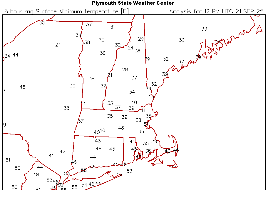
31.3 this morning in the lowlands just south of Lake Sunapee.
-
8' x8' photo of a tree on a house in Hamden in 89- now theres some damage https://www.auctionninja.com/smiths-online-estate-sales/product/mounted-photograph-1989-tornado-damage-hamden-ct-4098151.html
-
Delighted that my tomatoes and peppers shall continue for another couple of weeks. Very late ripening this year, but the sweetness of the tomatoes in unparalled for me, and there are dozens left that are close to ripe. Lotsa gazpacho in the freezer.
-
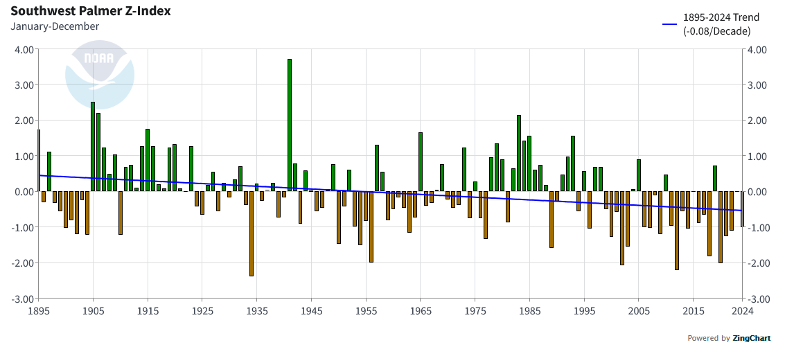
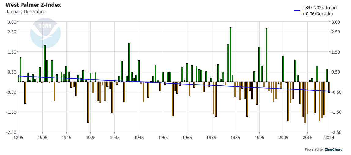
The recent summer pattern across the U.S. is a reversal of the Dust Bowl. The record heat has been located in the West and East with cooler and wetter in the middle. This is the opposite of the Dust Bowl with record heat and drought focused in the middle. https://journals.ametsoc.org/view/journals/clim/36/20/JCLI-D-22-0716.1.xml Abstract A cooling trend in summer (May–August) daytime temperatures since the mid-twentieth century over the central United States contrasts with strong warming of the western and eastern United States. Prior studies based on data through 1999 suggested that this so-called warming hole arose mainly from internal climate variability and thus would likely disappear. Yet it has prevailed for two more decades, despite accelerating global warming, compelling reexamination of causes that in addition to natural variability could include anthropogenic aerosol–induced cooling, hydrologic cycle intensification by greenhouse gas increases, and land use change impacts. Here we present evidence for the critical importance of hydrologic cycle change resulting from ocean–atmosphere drivers. Observational analysis reveals that the warming hole’s persistence is consistent with unusually high summertime rainfall over the region during the first decades of the twenty-first century. Comparative analysis of large ensembles from four different climate models demonstrates that rainfall trends since the mid-twentieth century as large as observed can arise (although with low probability) via internal atmospheric variability alone, which induce warming-hole-like patterns over the central United States. In addition, atmosphere-only model experiments reveal that observed sea surface temperature changes since the mid-twentieth century have also favored central U.S cool/wet conditions during the early twenty-first century. We argue that this latter effect is symptomatic of external radiative forcing influences, which, via constraints on ocean warming patterns, have likewise contributed to persistence of the U.S. warming hole in roughly equal proportion to contributions by internal variability. These results have important ramifications for attribution of extreme events and predicting risks of record-breaking heat waves in the region.
-
we only dropped to 34. growing season lives on DAVID LUDLUM WEATHER MUSEUM CONTENTS BEING AUCTIONED TODAY. https://www.auctionninja.com/smiths-online-estate-sales/sales/details/the-roger-brickner-estate-haverhill-corners-nh-on-site-pick-up-only-116.html Did you ever want a painting depicting Don Kent and the 78 Blizzard or some books of weather reports from 1862? Here is your shot a few of the items https://www.auctionninja.com/smiths-online-estate-sales/product/historical-weather-maps-meteorology-4098167.html https://www.auctionninja.com/smiths-online-estate-sales/product/large-o-c-don-kent-tv-weatherman-ne-blizzard-of-1978-4097766.html https://www.auctionninja.com/smiths-online-estate-sales/product/large-mark-carroll-oil-on-canvas-ne-hurricane-4097763.html Some cool stuff but unfortunately I can't make the pickup hours.
-
Some 6z EPS members starting to develop something now
-
Mins. Growing season is pretty much over north of Winni.
-
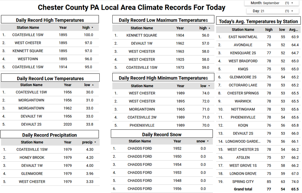
The 0.74" that fell from those rounds of thunderstorms yesterday evening until about midnight sets a new rainfall record for date, breaking 2015's 0.40 inches. Surprised how low that number is considering we are in prime tropics season, must have been swings and misses here. Anyway, starting day off in the fog and 57.4/56.8. That also took care of worrying about 'dry September's', lol.
-
Played golf for the second time in my life the other day down in PA. Butter valley golf course. Was with old college friends. Actually did ok. May get a set of used clubs soon.
-
50.2 here.. aahhhhh. Totally fake airmass
-
Even upper 30s on the Cape. Looks like a touch of frost by KTAN.
-
Well that’s it for awhile. Will be 80+ in many areas Tuesday.
-
Down in baldwinville I saw a 33.. I'm sure there's some good frost just down the hill..
-
Occasional Thoughts on Climate Change
donsutherland1 replied to donsutherland1's topic in Climate Change
UHI is effectively addressed in the adjustments. One needs all temperatures to get a good understanding of climate change. https://www.ncei.noaa.gov/pub/data/ushcn/papers/hausfather-etal2013.pdf -
Thanks. Some incredibly warm Long Island sound temps as well for this time of year.

-
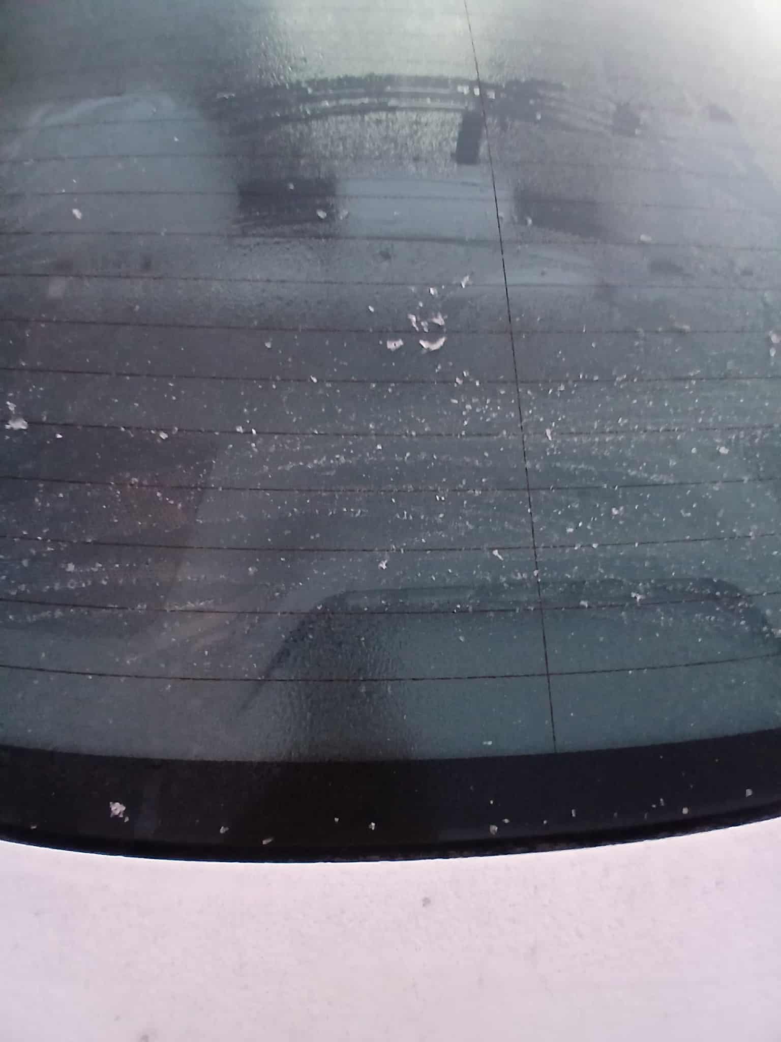
Thats great .. my windows had the slightest bit of frost this morning.. its weird though the top of my car was iced over but the rest was mostly wet.. still manged to get a pic though

-
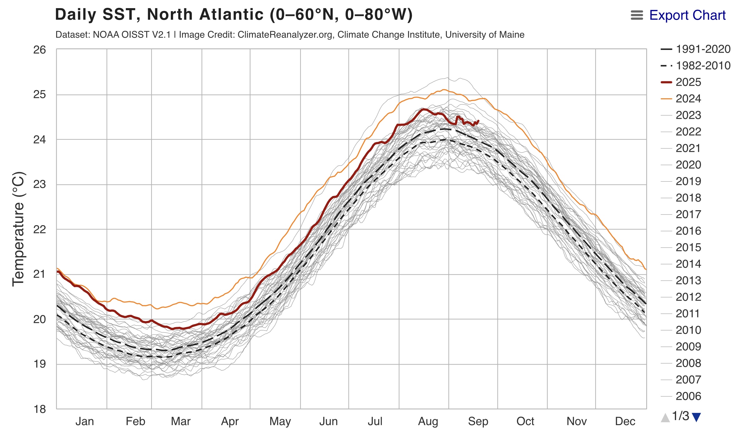
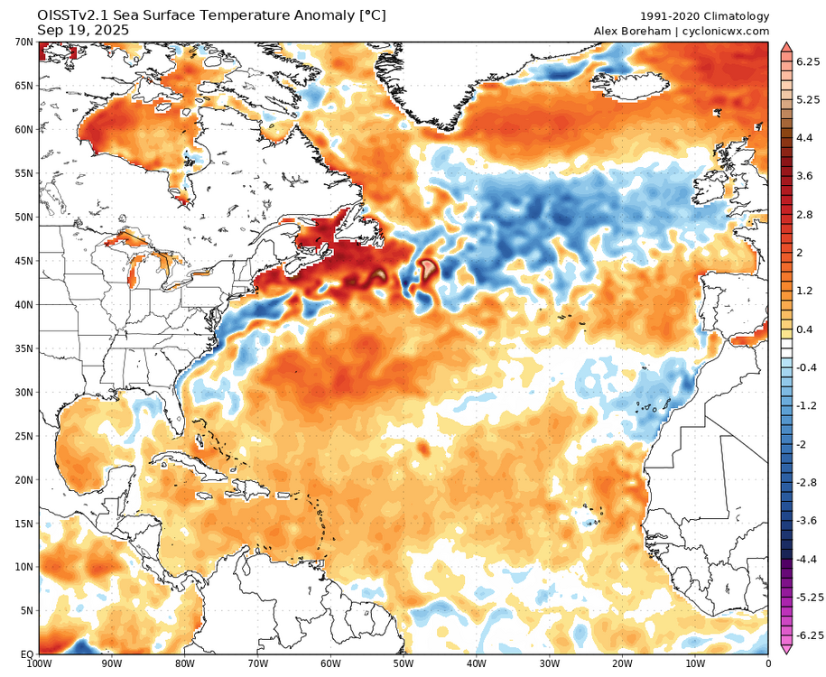
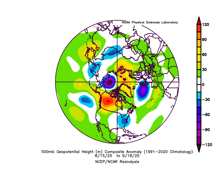
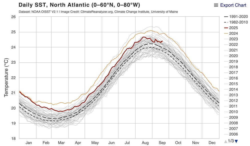
Still looks pretty warm to me since the Atlantic is currently the 5th warmest on record for the date. We also have to remember that this is the warmest 1991-2020 climo. So the actual historical ranking is pretty high. The cold pool west of Ireland is from the locally stronger winds there with the deep low pressure.
-
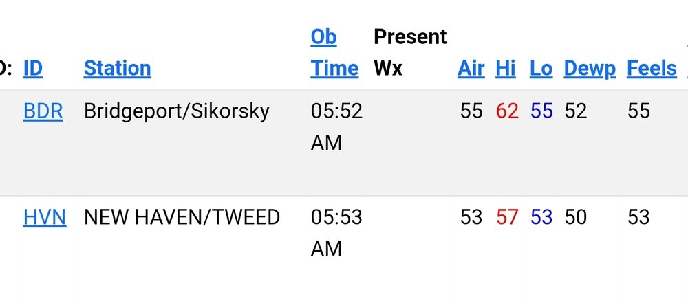
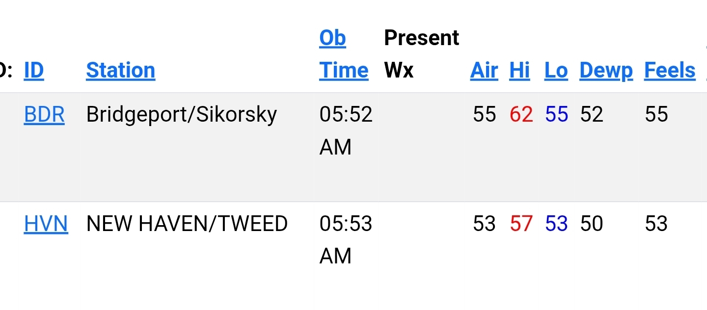
I’ve been watching HVN for a year. More often than not it’s way warmer than stations around it and BDR. They’ll be a day here or there where local nuances might make them close, but as Brian posted above, it seems to run mild. No doubt it’s been warm in the shoreline there.
-
29-30 this morning, less frost than yesterday - not enough moisture.
-
So the data indicates it's off by possibly 2 degrees? Seems to run very close to BDR. There's also like a half dozen or so WU stations near HVN that seem to run pretty close to it.