All Activity
- Past hour
-

Potential Tropical Cyclone Nine
WxWatcher007 replied to WxWatcher007's topic in Tropical Headquarters
As I hope we all learned yesterday, we’re nowhere near having all the answers on the medium and longer range track. From the very beginning we knew Humberto and the steering pattern made this a highly complex forecast and some of us kind of settled into believing a false consensus on the models—myself included. I don’t think we know what’s going to happen yet. We just have to keep monitoring and communicating the track uncertainty. There’s also fairly substantial intensity uncertainty. Recon is in the PTC and is finding westerly winds now so it’s on an organizing trend even if the low is still broad. We will eventually have a defined enough center for a TC designation. Importantly, this is on the edge of the deep convection firing north of Cuba. In this kind of situation we have to watch for center reformations if deep convection continues, which here could significantly impact track. One thing is clear: the PTC is organizing at a steadier pace given the recon findings and satellite appearance. -

Potential Tropical Cyclone Nine
donsutherland1 replied to WxWatcher007's topic in Tropical Headquarters
Courtesy of the Fujiwhara Effect, my thinking is that the stronger Humberto will pull what will become Imelda away from the coastline before U.S. landfall can occur and before ridging can rebuild overhead to break down the steering currents and later redirect Imelda toward U.S. landfall. The Bahamas and possibly Bermuda will need to closely monitor the developing tropical cyclone.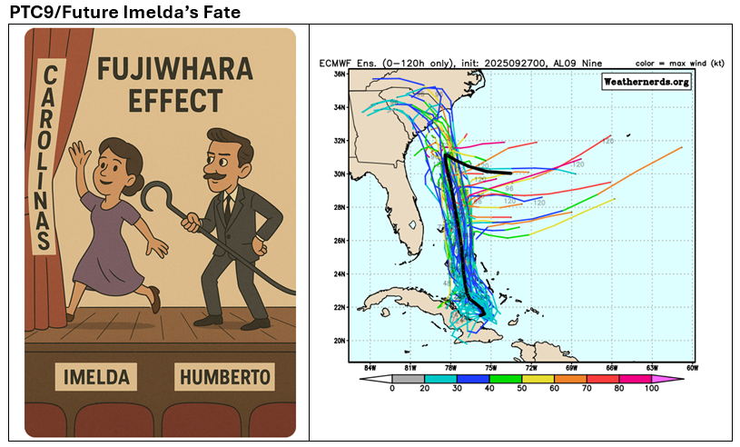
-

September 2025 OBS-Discussion centered NYC subforum
Sundog replied to wdrag's topic in New York City Metro
We did have that major flooding event in East Queens and Western Nassau during the summer too. But obviously that's localized. But extremely rare either way. -
It’s already happening
-
September 2025 OBS-Discussion centered NYC subforum
Sundog replied to wdrag's topic in New York City Metro
When? -
Stein bragging heavily this morning.
-
I am hoping for Stein through Morch, but it means much much less outside of growing season, summer, high sun angle etc.
-
Picked up .49" overnight. This brings my monthly total to 2.07".
-
The evergreens have leaves? Sent from my SM-S921U using Tapatalk
-
Euro AI is back to the idea of running this up the coast as it gets trapped under the ridge and the Euro at 144 seems like it wants to trap future Imelda as well. Not worth much at this time but still something to watch. If the ridge doesn’t roll over to block the escape route future Imelda goes right OTS.
-

September 2025 OBS-Discussion centered NYC subforum
SACRUS replied to wdrag's topic in New York City Metro
Records: Highs: EWR: 91 (1998) NYC: 90 (1933) LGA: 90 (1988) JFK: 89 (1998) Lows: EWR: 35 (1947) NYC: 41 (1957) LGA: 43 (1947) JFK: 46 (2000) Historical: 1816 - A black frost over most of New England kills unripened corn in the north resulting in a year of famine. (David Ludlum) 1822: Using various documents and meteorological observations determined a hurricane moved ashore on this day in South Carolina. One account from Bull Island, South Carolina records the eye passing directly over that location. 1822: Mail south of Richmond was unable to be delivered for three days, as the storm rendered roads impassable. At Monticello, near Charlottesville, Thomas Jefferson's granddaughter noted that a violent storm broke branches and felled one of their willows. At Lynchburg, winds uprooted trees and toppled chimneys. Along the Staunton River, rains began on the 27th and continued until 9 a.m. the next day. The river rose to "the greatest height ever known." (Chapman) (Ref. for Charleston Hurricane) 1906: The second September storm of 1906 was one of great violence. On the 27th the hurricane reached the central Gulf Coast with destructive winds and unprecedented tides. At Pensacola, FL, the tide was 10 feet above normal. At Mobile, AL property damage was severe. An estimated 134 lives were lost from Pensacola, FL to Mississippi from this storm. 1936: Denver, Colorado: Early season snowstorm buries Denver. Storm total of 21.3 inches falls at airport in 60 hours. (Ref. AccWeather Weather History) 1942: Snowflakes flew across parts of Lower Michigan as temperatures fall to the lower 30s and only rose into the 40s during the day. Fort Wayne, IN reported a trace of snow on this date and two days prior. These dates remain the only two September snowfalls on record at that location. (Ref. Wilson Wx. History) 1955: The U.S. Weather Bureau's station on Swan Island in the western Caribbean was destroyed as Hurricane Janet passed very close to the island. Winds gusts were estimated to have reached 200 mph. Janet made landfall at Chetumal, Mexico early on the 28th where winds were sustained at 175 mph and the pressure dropped to 914 millibars or 27.00 inches of mercury. Over 500 people were killed and damage exceeded $40 million. (Ref. AccWeather Weather History) 1958: Hurricane Helene passed just off the North Carolina coast. Wilmington had sustained winds of 88 mph with a peak gust of 135 mph, a record and recorded 8.29 inches of rain. Cape Fear was battered by sustained winds of 125 mph with gusts to 155 mph. This was a near miss however as the eye remained about 20 miles offshore and thus the tides were not excessive. Total damage was $11 million dollars. (Ref. Daily News Record Newspaper - Harrisonburg, Virginia) (Ref. AccWeather Weather History) 1959 - A tornado 440 yards in width traveled twenty miles from near Hollow, OK, to western Cherokee County KS. Although a strong tornado, it was very slow moving, and gave a tremendous warning roar, and as a result no one was killed. (The Weather Channel) 1970 - Afternoon highs of 103 degrees at Long Beach, CA, and 105 degrees at the Los Angeles Civic Center were the hottest since September records were established in 1963. Fierce Santa Ana winds accompanying the extreme heat resulted in destructive fires. (The Weather Channel) 1985 - A record early season snowstorm struck the Central High Plains Region. The storm left up to nineteen inches of snow along the Colorado Front Range, and as much as a foot of snow in the High Plains Region. (Storm Data) 1985 - Hurricane Gloria swept over the Outer Banks then rushed across Long Island, New England, and Canada. It was the first significant hurricane to hit New England in twenty-five years and brought heavy rains and high winds to the Mid-Atlantic states as well. 984 Tropical Storm Isidore made landfall near West Palm Beach during the morning hours. From there it moved slowly to near Orlando in the evening, then recurved to the northeast and crossed over Jacksonville and out to sea the next day. The highest wind gust was 73 mph near St. Augustine. Rainfall of 5 to 7 inches in north Florida caused local flooding. Heavy snow fell across parts of the Plains and Colorado Foothills. Snowfall totals ranged from 2 to 5 inches across the Plains with up to a foot in the higher elevations in the Foothills. The main problem caused by the storm was thousands of power outages caused by snapped tree limbs falling on power lines. Some cars were damaged by falling trees and limbs. The snow also caused flight delays at Denver where just over 5 inches of snow fell. The high temperature the next day in Denver only managed to make it to 34°, a record low maximum for the date and equaled the all-time September record up to that time. (Ref. Wilson Wx. History) 1985: Hurricane Gloria today makes landfall on western Long Island, New York with sustained winds of 85 mph. (gusts to 115 mph.), moving at 35 mph., Pressure 28.37 inches or 961 mb. and a storm surge of 4- 7 feet above Mean Tide. Hurricane Gloria was one of the most intensely reported events of the 1980's. Gloria hit New York and Connecticut as a moderate hurricane in September 1985. Although Gloria was not a major hurricane when it struck Connecticut, it was significantly more damaging to Connecticut than Hurricane Belle (1976) and Hurricane Donna (1960). Gloria at one time had a central pressure of 919 mb (27.13 in.), and sustained winds of 150 mph. - making Gloria almost a category five hurricane. At this time, Gloria was one of the largest and most intense cyclones to ever threaten the middle and north Atlantic states in several generations. Gloria brushed the North Carolina Outer Banks near midnight on September 27, with sustained winds of 105-mph and a central pressure of 27.83 inches (942 mb). The Diamond Shoals light-tower sixteen -miles off the North Carolina coast, recorded sustained winds of 98-mph with gusts to 120-mph. Gloria continued to accelerate northward off the eastern US coast brushing the coast of Virginia, Maryland, Delaware, and New Jersey with hurricane-force gusts. Gloria finally crossed the coast of the United States mainland near western Long island, New York about 10-miles east of Kennedy International Airport. Passing over central Long Island, Gloria crossed the Connecticut coast near Bridgeport about 40-minutes later with sustained winds of 80-mph. 1987 - While those at the base of Mount Washington, NH, enjoyed sunny skies and temperatures in the 70s, the top of the mountain was blanketed with 4.7 inches of snow, along with wind gusts to 99 mph, and a temperature of 13 degrees. Severe thunderstorms developed along a cold front in the south central U.S. A thunderstorm west of Noodle TX produced golf ball size hail and wind gusts to 70 mph. (The National Weather Summary) (Storm Data) 1988 - Thunderstorms developing ahead of a cold front produced large hail in southeastern Wyoming during the afternoon, with tennis ball size hail reported at Cheyenne. Strong winds ushering the cold air into the north central U.S. gusted to 59 mph at Lander WY. (The National Weather Summary) (Storm Data) 1989 - Freezing temperatures were reported in the Great Lakes Region and the Ohio Valley. Houghton Lake MI reported a record low of 21 degrees. Thunderstorms in the western U.S. produced wind gusts to 50 mph at Salt Lake City UT, and gusts to 58 mph at Cody WY.(The National Weather Summary) (Storm Data) 2014: A squall line impacted central Arizona, including the Phoenix Metro area. -
BOS pulled off a +13.5F yesterday. -0.5F MTD ORH had +10.0F +0.9F MTD
-
September 2025 OBS-Discussion centered NYC subforum
SACRUS replied to wdrag's topic in New York City Metro
61 / 59 partly / mostly cloudy. Warm today but clouds building in so 80s may be tough but close with any amount of sun later this morning / earlt afternoon. Rain overnight likely aimed at southern areas but should get north with some light rain. Dry out warm up Sunday and Monday. Imelda and Humberto tango and look to pull out, we get a cooler NE flow 10/2 - 10/3 before ridge buiilds inand and an overall warmer beyond there. RIdge east / trough west. Rain tonight will be the best chance for the next 5 days at least. 9/27 - 9/30 : Much warmer than normal - some rain Sat overnight into Sunday 10/1 : Near normal - cooling 10/2 - 10/4 : Cooler ENE/NE flow 10/5 - Beyond : Warmer - much warmer than normal -
-
Euro too. Some are confused.
-
It had the stall and move east before the Euro/GFS and ensembles. The AI models have actually been excellent this season on balance. Of course, we’ll see how this all verifies.
-
Is anyone besides me having problems accessing a few weather sites all of the sudden? Specifically: - the NOAA river gauge site: https://water.weather.gov/ - Mike's weather page:https://www.spaghettimodels.com/ Mike's seems to be really spotty the last several days, for me at least (it's down right now). Wondering if it's just me. Thanks Edit: I guess they moved the NOAA site - it's now https://water.noaa.gov/
-
Honestly this is a good thing if it goes OTS. Some of the early tracks and rainfall totals for the western Carolinas was devastating. As much as I’d like to see some wind and rain, this may be a saving grace for those folks in the mountains.
- Today
-
September 2025 OBS-Discussion centered NYC subforum
SACRUS replied to wdrag's topic in New York City Metro
Imelda to be fuijwahara from Humberto may spare a landfall with recent trends / forecasts -
Love it.
-
September 2025 OBS-Discussion centered NYC subforum
SACRUS replied to wdrag's topic in New York City Metro
Coole r E/ENE flow looks for 2 days 10/2-10/3 before ridge builds in with warmer flow. -
Good thing we got a little rain because he’s back
-

Potential Tropical Cyclone Nine
NorthHillsWx replied to WxWatcher007's topic in Tropical Headquarters
Also Bermuda is in play -

September 2025 OBS-Discussion centered NYC subforum
tmagan replied to wdrag's topic in New York City Metro
We are about 40 years to the hour that Hurricane Gloria made landfall on Long Island, the last landfall of a hurricane on Long Island. -

September 2025 OBS-Discussion centered NYC subforum
bluewave replied to wdrag's topic in New York City Metro
Multiple record warm high and low temperatures at Islip in late September have raised it to the 5th warmest September on record. Numerous top 10 warmest finishes in recent years. Since the new 1991-2020 climate normals are so warm, it only took a +1.7 departure to reach a top 10 warmest ranking. RECORD EVENT REPORT NATIONAL WEATHER SERVICE NEW YORK, NY 0432 PM EDT FRI SEP 26 2025 ...RECORD HIGH TEMPERATURE SET AT ISLIP NY... A RECORD HIGH TEMPERATURE OF 85 DEGREES WAS SET AT ISLIP NY TODAY. THIS TIES THE OLD RECORD OF 85 DEGREES SET IN 1970. RECORD EVENT REPORT NATIONAL WEATHER SERVICE NEW YORK, NY 234 AM EDT THU SEP 25 2025 ...RECORD DAILY HIGH MINIMUM TEMPERATURE SET AT ISLIP NY... THE LOW TEMPERATURE WAS ONLY 70 DEGREES WEDNESDAY, SEPTEMBER 24 AT ISLIP MACARTHUR AIRPORT. THIS BREAKS THE OLD RECORD HIGH MINIMUM OF 69 DEGREES, SET IN 1970. RECORDS FOR THE ISLIP NY AREA GO BACK TO 1963. RECORD EVENT REPORT NATIONAL WEATHER SERVICE NEW YORK, NY 0433 PM EDT FRI SEP 19 2025 ...RECORD HIGH TEMPERATURE SET AT ISLIP NY... A RECORD HIGH TEMPERATURE OF 85 DEGREES WAS SET AT ISLIP NY TODAY. THIS TIES THE OLD RECORD OF 85 DEGREES SET IN 1983. RECORDS GO BACK TO THE YEAR 1963 AT THIS CLIMATE STATION. Time Series Summary for ISLIP-LI MACARTHUR AP, NY - Month of Sep Click column heading to sort ascending, click again to sort descending. 1 2015 70.9 0 2 2005 70.2 0 3 2018 69.8 0 4 2021 69.6 0 - 1980 69.6 0 5 2025 69.3 4 6 2017 69.0 0 - 2011 69.0 0 7 2016 68.9 0 8 2023 68.6 0 - 1998 68.6 0 9 2010 68.3 0 10 2022 68.2 0