All Activity
- Past hour
-
How many of them have a link they want you to click so they can get subscriptions? Look I don’t doubt there could be a cold/snowy December and many signs are pointing that way, but the “major cold and snow11!111!!” should be met with skepticism.
-

2025-2026 ENSO
40/70 Benchmark replied to 40/70 Benchmark's topic in Weather Forecasting and Discussion
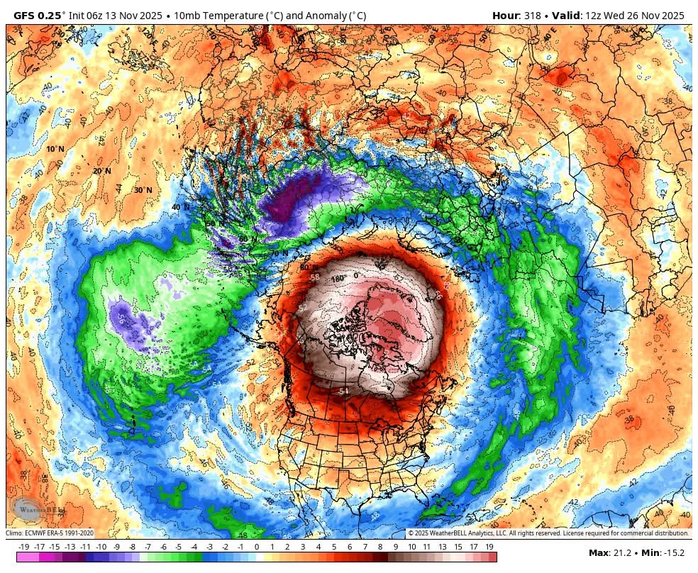
The only unusual element is in the event that the zonal wind actually reverses this early, which is still dubious IMHO. This is the latest example of how online forecasting is more geared towards attracting attention and generating revenue, as opposed to adding actual value. -
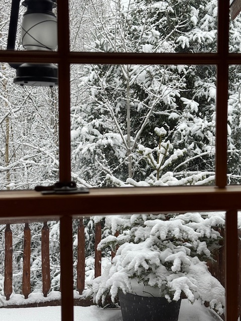
Same here - we’ve been stuck at 31.8 with light snow. Looks great though!
-
After a true winter's day two days ago (29/16), it didn't make it below freezing last night and poof, there went our little snow cover. Going to be beautiful the next few days at least.
-
Soon, Barney will come to an eastern US location near you!
-

Winter 2025-2026 Thoughts
MJO812 replied to donsutherland1's topic in Weather Forecasting and Discussion
You might be too low with those numbers if December turns out wintry and cold like the pattern is signaling. Well detailed post though -
The recent cold records across the Southeast occurred at both urban and rural sites. So it was the function of the cold Arctic airmass and not radiational cooling. Since even rural areas of the Northeast that radiate well have been missing the cold records at a similar rate as our more urban areas have.
-
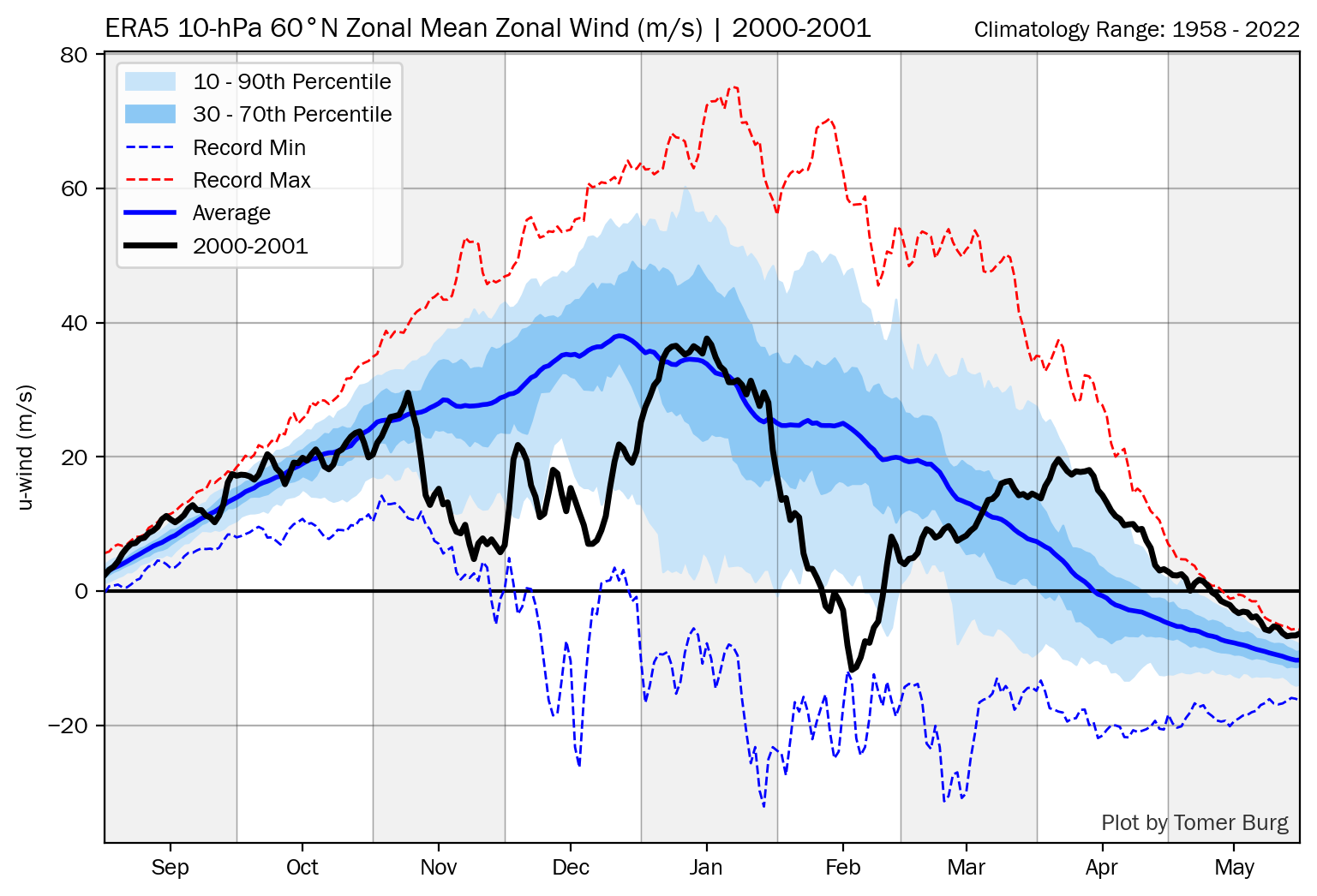
Ray, You have to go to the bottom of this and then choose the winter: http://arctic.som.ou.edu/tburg/products/realtime/strat/ Unfortunately, one can go back only to 1990-1 from this source for some reason even though graphs exist back at least to 1958-9.
-
I have watched so many videos on YouTube stating this is an unusual event unfolding and watch out for major cold and snow in the east coming up.
-

Central PA Fall Discussions and Obs
TimB replied to ChescoWx's topic in Upstate New York/Pennsylvania
Someone who doesn’t get it. Enjoy the new website and the 0.000005 page views per day. -
There may be something else at work which links back pretty far in the human collective experience. We evolved through very cold conditions during ice ages when many didn’t survive the harsh conditions. So the cold was something to be feared in generations since those experiences. Warmer conditions were something to be welcomed following these harsh eras. So we don’t have experience yet as a species of warmth being something to be feared. Instead at least in the U.S, most of our internal migration has been from colder climates to warmer ones. This forum is really in the minority. Since most people outside our forum would be happy if we didn’t really have winters at all. It’s why so many go to Florida during the winters. If you notice an Arctic outbreak or snowstorm usually gets much more media attention than a heatwave. My guess is that this natural disposition is hardwired into us from cold and snow being associated with negative consequences for us.
-
(002).thumb.png.6e3d9d46bca5fe41aab7a74871dd8af8.png)
Central PA Fall Discussions and Obs
ChescoWx replied to ChescoWx's topic in Upstate New York/Pennsylvania
And only 18% before 1955....interesting...not really cyclical climate in action!! LOL!! -
Thanks Don. The failed blocking episodes prior to last year all included an RNA, which makes the "blocking no longer works" commentary even more perplexing (not from you). Last years blocking failed due suppression of course.
-
2025-2026 ENSO
40/70 Benchmark replied to 40/70 Benchmark's topic in Weather Forecasting and Discussion
Larry, what is the link to get that historical 60* mean zonal wind data? Thanks. -

Central PA Fall Discussions and Obs
Mount Joy Snowman replied to ChescoWx's topic in Upstate New York/Pennsylvania
Low of 42 with a rounded-up .01" of rain. -
actually, it has a lot to do with radiational cooling combined with what you said. I’m telling you as somebody that’s been flying these routes for 25 years, they radiate better in the interior southeast than we do here and it isnt unusual to see a place like RDU cooler than LGA in Nov/Dec on clear still nights…until the core of the cold season sets up. You are in front of your computer a lot, take a look at the historical records sir.
-
Incredibly tricky temperature forecasts this weekend. Warm air will be lurking just our south and southwest, but there is increasing concern now that we'll end up on the cooler side of the boundary each day.
-
I for one would welcome a front loaded winter, the last decade has been dominated by truly awful Decembers. From everything I’m seeing and reading, this year could finally buck the trend.
-
The cool departures EWR: 11/11 : 42/ 33 (-10) 11/ 2: 51 / 39 (-3) NYC: 11/11: 41 / 22 (-12) 11/12: 50 / 38 (-5) LGA: 11/11: 43 / 34 (-13) 11/12: 51 / 39 (-5) JFK: 11/11: 42 / 33 (-10) 11/12: 51 / 39 (-3) TTN: 11/11: 42 / 30 (-10) 11/12: 51 / 36 (-2)
-
Major stratospheric warming event going on.. usually means in about 2 to 3 weeks cold train coming! We will see!!

-
So far, pretty placid relatively speaking for us here near NYC, into Thanksgiving.
-

2025-2026 ENSO
donsutherland1 replied to 40/70 Benchmark's topic in Weather Forecasting and Discussion
I agree. Hopefully, CPC will start using RONI as its official measure. In any case, the relationship holds true with ONI or RONI. -
Records: Highs: EWR: 74 (1931) NYC: 73 (1931) LGA: 70 (1964) JFK: 71 (1964) Lows: EWR: 22 (2019) NYC: 23 (2019) LGA: 24 (2019) JFK: 23 (2019) Historical: 1833: In 1833, observers were familiar with the Leonid meteor shower, but the event that year was very intense and leads to the first formulation of a theory on the origin of meteors. By some estimates, the 1833 Leonid meteor shower had 240,000 meteors in a nine-hour period. 1879: Nov. heat wave hits DC with second latest 80° reading ever to this date. (Ref. Washington Weather Records - KDCA) 1881: Hailstones from a tremendous storm that hit Georgia on the 8th were still visible nearly a week later at Dry Pond, GA. (Ref. AccWeather Weather History) 1904: This hurricane moved north to near Cape Hatteras. As the system became nontropical, cold air on the west side of the circulation set up an early snowstorm across North Carolina. A twenty-four hour rainfall record was set for November at Farmville (3.17"). Richmond, VA had 1.65 inches precipitation and 1.8 inches of snow from this storm. A Late East Coast Storms (Ref. Richmond Weather Records.) 1933 - The first dust storm of the great dust bowl era of the 1930s occurred. The dust storm, which had spread from Montana to the Ohio Valley the day before, prevailed from Georgia to Maine resulting in a black rain over New York and a brown snow in Vermont. Parts of South Dakota, Minnesota and Iowa reported zero visibility on the 12th. On the 13th, dust reduced the visibility to half a mile in Tennessee. (David Ludlum) (The Weather Channel) 1938: Snowstorm across Northern Minnesota. Barometer falls to 29.31 in Duluth,MN. (Ref. AccWeather Weather History) 1946 - General Electric scientists produced snow in the Massachusetts Berkshires in the first modern day cloud seeding experiment. (The Weather Channel) 1946: General Electric scientists produced snow in the Massachusetts Berkshires in the first modern-day cloud seeding experiment. Scientist Vincent Schaefer dropped six pounds of dry ice pellets into a cloud over Pittsfield, MA. The cloud seeding experiment produced snowfall, as a 4-mile long cloud was converted into snow flurries. The success of the experiment became the basis of many weather modification projects. 1953 - Strong southeasterly winds associated with a Pacific cold front reached 70 mph at Sacramento CA to equal their all-time record. The previous record had been established in a similar weather pattern on December 12th of the previous year. (The Weather Channel) 1981 - A powerful cyclone brought high winds to Washington State and Oregon. The cyclone, which formed about 1000 miles west of San Francisco, intensified rapidly as it approached the Oregon coast with the central pressure reaching 28.22 inches (956 millibars). A wind trace from the Whiskey Run Turbine Site, about 12 miles south of Coos Bay in Oregon, showed peak gusts to 97 mph fifty feet above ground level. The wind caused widespread damage in Washington and Oregon, with 12 deaths reported. As much as four feet of snow fell in the Sierra Nevada Range of northern California. (Storm Data) 1986: High temperatures are held in the upper teens to lower 20s as arctic air pours into Lower Michigan. The high of 19° at Grand Rapids, MI is a record for the date and the coldest high temperature for so early in the season. Widespread record lows were set from the Plains to the Southeast including: International Falls, MN: -12°, Duluth, MN: -7°, North Platte, NE: -7°, Marquette, MI: -5°, Sioux City, IA: -4°, Rochester, MN: -4°, Omaha, NE: -2°, Waterloo, IA: -1°, Minneapolis, MN: 0°, Dubuque, IA: 1°, Green Bay, WI: 2°, La Crosse, WI: 2°, Madison, WI: 2°, Concordia, KS: 2°, Kansas City, MO: 3°, Rockford, IL: 3°, Ste. St. Marie, MI: 4°, Topeka, KS: 4°, Springfield, MO: 5°, Milwaukee, WI: 5°, Moline, IL: 5°, Chicago, IL: 6°, Columbia, MO: 7°, Springfield, IL: 7°, St. Louis, MO: 10°, Indianapolis, IN: 10°, Grand Rapids, MI: 10°, Paducah, KY: 10° (broke previous record by 10 degrees), Beckley, WV: 12°, Dayton, OH: 13°, Bristol, TN: 19°. (Ref. Wilson Wx. History) 1987 - A storm moving off the Pacific Ocean produced rain and gale force winds along the northern and central Pacific coast, and heavy snow in the Cascade Mountains. Cold weather prevailed in the southeastern U.S. Five cities reported record low temperatures for the date, including Asheville NC with a reading of 21 degrees. (The National Weather Summary) (Storm Data) 1988 - Low pressure brought rain and snow and gusty winds to the northeastern U.S. A thunderstorm drenched Agawam MA with 1.25 inches of rain in fifteen minutes. Winds gusted to 58 mph at Nantucket MA. (The National Weather Summary) (Storm Data) 1989 - Thirty-two cities in the central and eastern U.S. reported record high temperatures for the date as readings warmed into the 70s as far north as Michigan and Pennsylvania. Afternoon highs in the 80s were reported from the Southern Plains to the southern Atlantic coast. Columbia SC reported a record high of 86 degrees, and the high of 71 degrees at Flint MI was their warmest of record for so late in the season. (The National Weather Summary) 1999: Over 135 daily record highs were established across the western and central United States as an unseasonable 588 decameter heat ridge dominated. Lincoln and Omaha, NE set their all-time November high temperature records with 85° and 83° respectively. Lincoln broke their previous record by 11 degrees. Springfield, MO tied their all-time November record with 81° as did Idyllwild, CA with 80°. (Ref. AccWeather Weather History)
-
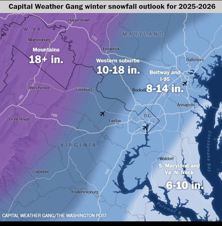
WP forecast is for slightly below average snowfall and the article is a good reference because it provides a summary/link of the local forecaster's winter forecasts. General theme is more snow for the NW zones this year. https://www.washingtonpost.com/weather/2025/11/13/dc-winter-forecast-snow-2025-2026/
-
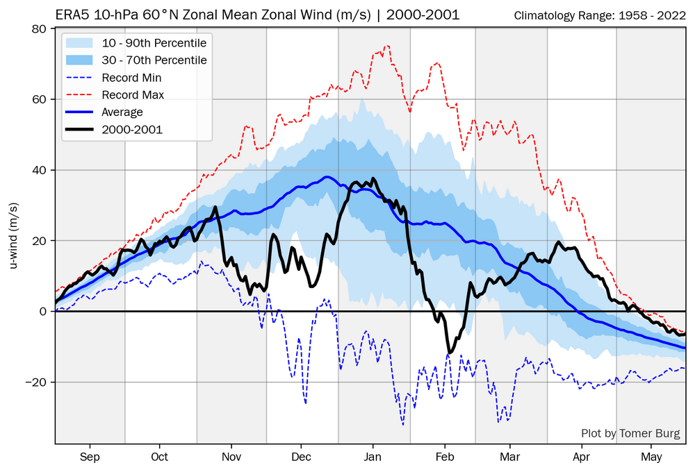
There are no official Nov or Dec major SSWs based on reversals at 10 mb for any of 1983, 1989, and 2000. To be fair if you read this closely, BAMwx isn’t explicitly saying that there was an early major SSW in any of those 3 years (if they were they’d be wrong): A few of these years were absolutely blockbuster in December. Chances to replicate the intensity of cold in years like 2000, 1989 and 1983 are unlikely, but there is strong support notable cold the first half of December setting up. That’s not to say that the SPV wasn’t weak. Despite no reversal, 2000 was quite weak mid-Nov through Dec with a low of +4 to +5 m/s in late Nov as per the chart below: (I don’t have these charts for 1983 and 1989….does anyone else have a link to them?):

.thumb.JPG.418e8a9a2902ae687ec35ff4bc0e038e.JPG)