All Activity
- Past hour
-
The 12z EPS looks like a washed out version of the deterministic which I posted a few posts back. Good trends.
-
The green is convection, right...or is it the brown?
-
If you enjoy snow. Where I was when I seen 6ft in 24hrs.
-
is hamburg NY a nice place to live?
-
Flurries here on Staten Island
-

New Years Day 2026 - 1st snows of the new year possible
Damage In Tolland replied to Baroclinic Zone's topic in New England
I don’t think so . He was here a few different times over the years , but maybe he was for that one -

New Years Day 2026 - 1st snows of the new year possible
Tolland Death Band replied to Baroclinic Zone's topic in New England
The Tolland Massif’s shining moment. Was that the one where Ryan H was broadcasting from the green? -
Right now it appears that Monday's clipper is going too far north, but still 5 days to go. Hopefully we can get it to trend south so we can see a light accumulation.
-
If I had a dollar for everytime I heard the “better pattern just weeks away”
-
A light snow shower going on now.
-
Good read, thanks for posting. Please post more.
-
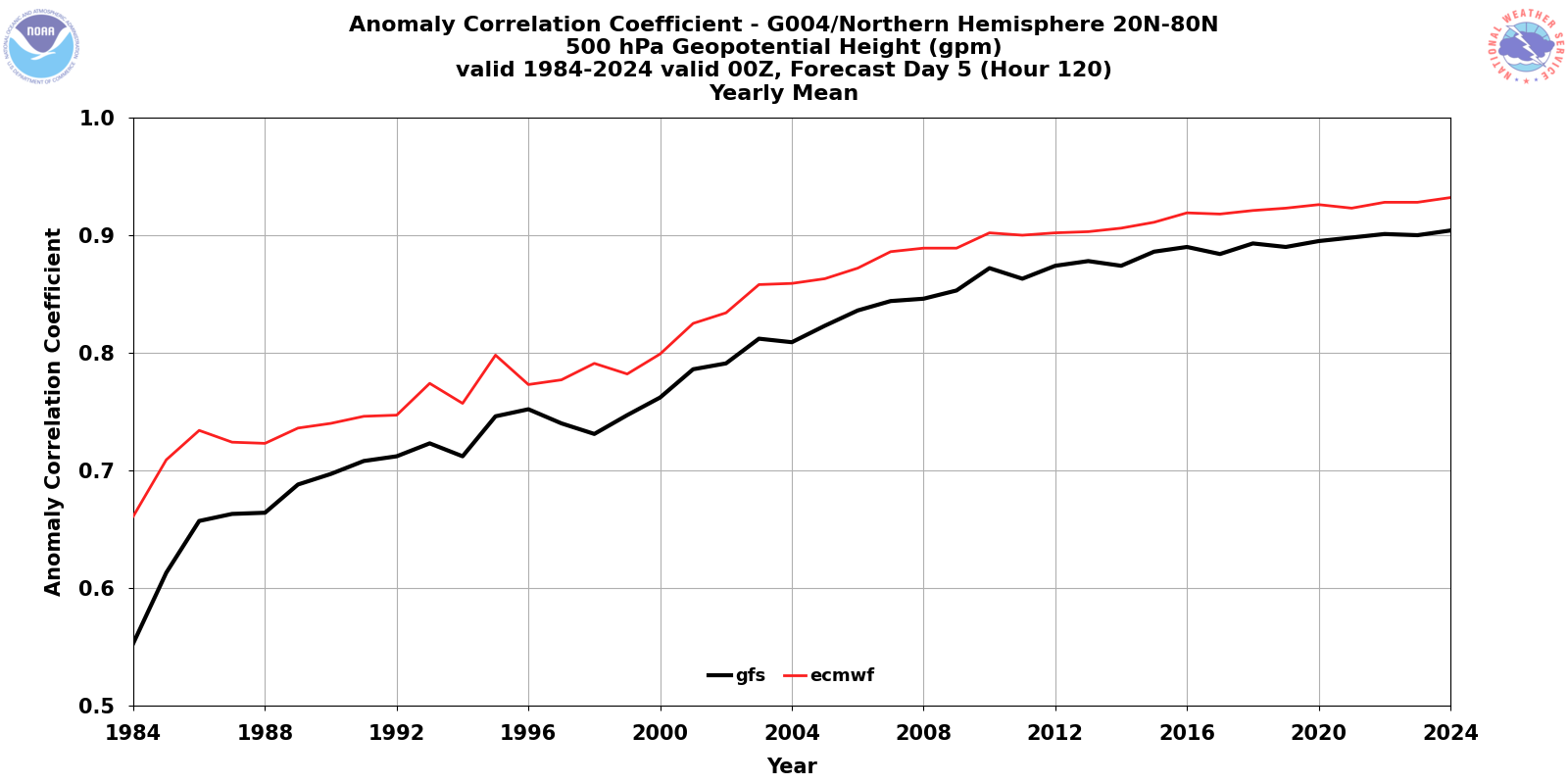
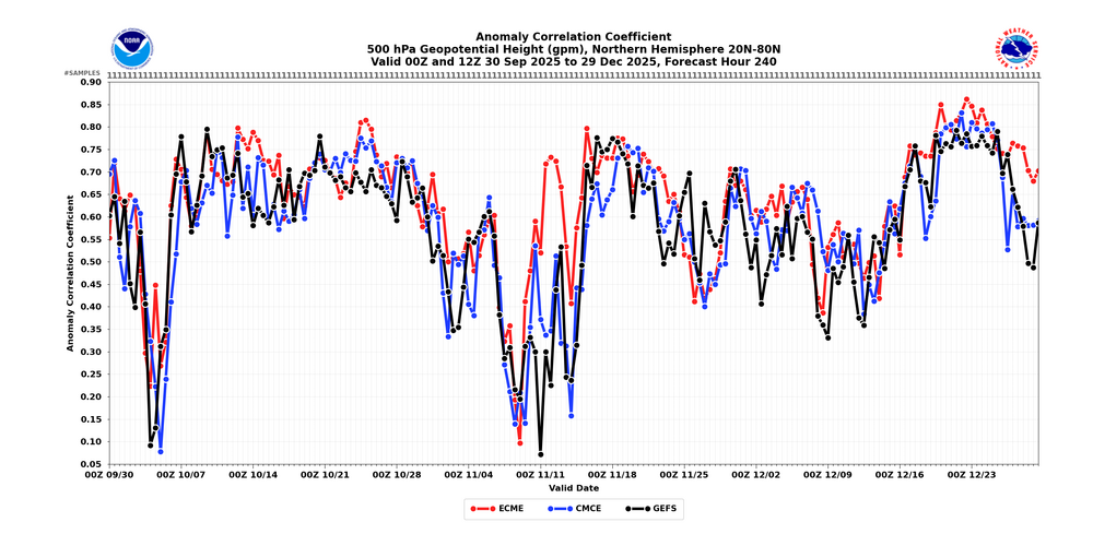
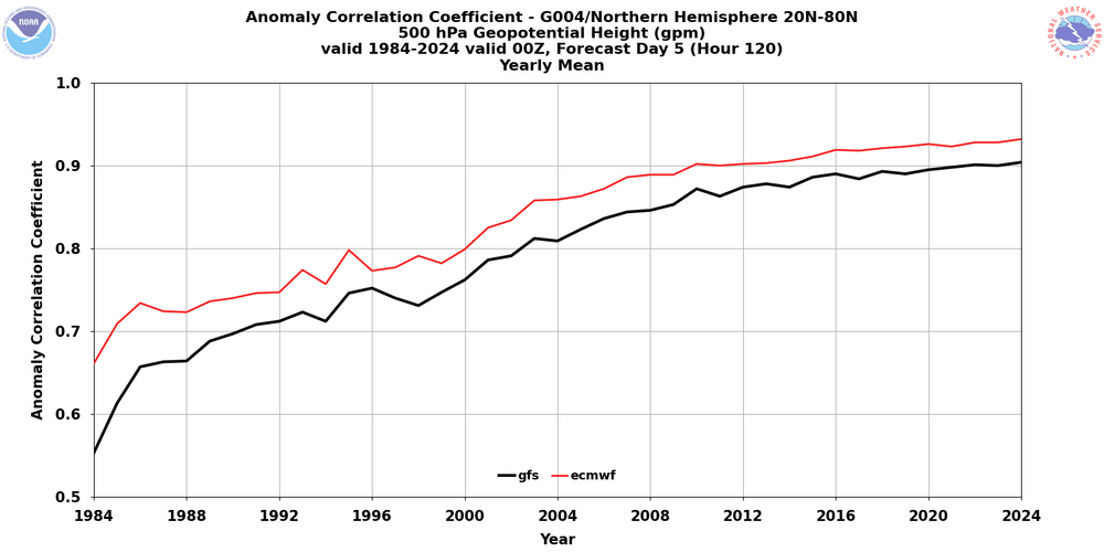
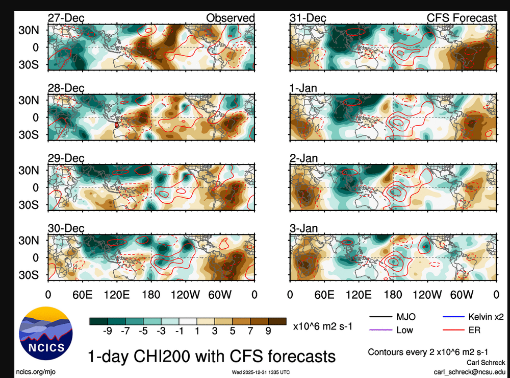
THIS. Even though our resident third graders want to moan that poor forecasts show that NWP is useless, there are certain patterns that for whatever reason just aren't predictable. The fact that all of the major world modeling ensemble systems showed something very encouraging for the end of the first week of January makes it clear that something about those forecasts (initial conditions generally driven by lack of observations or observational errors, the actual equations and parameterizations, numerical methods, or some combo of those) made skillful predictions impossible. But there are plenty of periods where guidance shows remarkable skill even at extended ranges. Here are the 500 mb anomaly correlation scores (the best measure of synoptic pattern success) for 10 day forecasts over the past 3 months for the 3 major ensemble systems (and yes, it only makes sense to verify ensembles at this range). A score of 1 is a perfect score, and the dates on the bottom are the days on which the forecasts verify, not when they're made. There were periods of poor performance by all 3 systems (early October and around November 9), periods of poor GEFS and GEPS performance but with the Euro doing fine (around November 12 and at the very end of December), periods of fair performance by all 3 (mid October), and periods of fantastic performance by all 3 (third week of November and especially the third week of December). Those scores between December 18 and Christmas are remarkable for 10-day forecasts and are numbers we could have only dreamed of 20 years ago. Advances in data assimilation and coupling of the ocean to the atmosphere in models will lead to even bigger improvements, and AI offers tremendous opportunities to run the massive size of ensembles needed to truly represent the uncertainty and potential for extreme events with more lead time. That doesn't mean that frustrations like those with the upcoming pattern will completely disappear, and it REALLY doesn't mean that we should soon expect models to lock in on a snowstorm 12 days out and never waver up until the day it happens. We just need to remember the current limitations and focus on consistency in patterns (and not details of deterministic runs at extended ranges) in ensembles, understanding that progress in forecasting the extended ranges doesn't preclude huge busts. I'll end with this plot of Day 5 anomaly correlation by year over the past 40 years (apologies for not having the values for Day 10). While the lines have flattened more than we'd like in the past 10 years (I think that AI is the way we'll see these rise again), and the GFS needs to catch up to the Euro, the progress is undeniable. Thanks for coming to my TED talk, and Happy New Year! pa
- 864 replies
-
- 12
-

-

-

-

New Years Day 2026 - 1st snows of the new year possible
klw replied to Baroclinic Zone's topic in New England
2 to 4 doesn't mean everyone gets 4 unless its Facebook in which case I heard we are getting almost half a foot. -
Better get something fast,it looks rather bleak right now down the road with that strong ERW thats fixing to pass along the IDL the next few days,Maybe it will weaken some but this could cause the tropical forcing to shit towards the WP into the MC,probably end up seeing RMM madness continue,you're seemingly starting to see the NINA background getting taken out now even tho it's still NINA.
-
New Years Day 2026 - 1st snows of the new year possible
Damage In Tolland replied to Baroclinic Zone's topic in New England
I remember models kept showing it and we never fully believed it. The radar had the snow falling over the valley but it all fell over the hills. Was fascinating event . It was torched away less than 2 days later . Here’s that radar https://imgur.com/a/E6cdjp4#w4DU9Zm -
Don’t know what the rest of winter holds, but this was a very solid December by our standards. Below to much below normal temps and normal to above normal snow for about everyone (sorry Winchester and Stephen’s City).
-
It’s always weeks away and it will stay there lol.
-

New Years Day 2026 - 1st snows of the new year possible
DavisStraight replied to Baroclinic Zone's topic in New England
He comes up with these memes super quick. -

New Years Day 2026 - 1st snows of the new year possible
The 4 Seasons replied to Baroclinic Zone's topic in New England
https://www.jdjweatherconsulting.com/mar-22-23-2019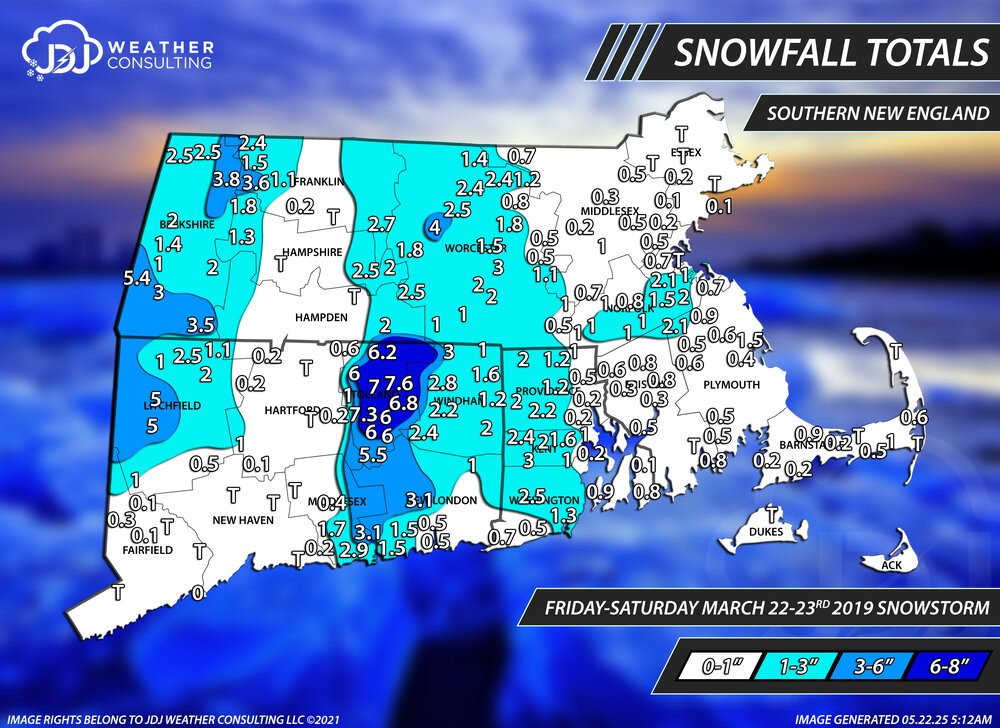
-

New Years Day 2026 - 1st snows of the new year possible
WinterWolf replied to Baroclinic Zone's topic in New England
Lmfao…. That’s crazy funny. -
New Years Day 2026 - 1st snows of the new year possible
WinterWolf replied to Baroclinic Zone's topic in New England
..that was good. -
New Years Day 2026 - 1st snows of the new year possible
Damage In Tolland replied to Baroclinic Zone's topic in New England
Not the same but it reminded me of this event . What a weenie event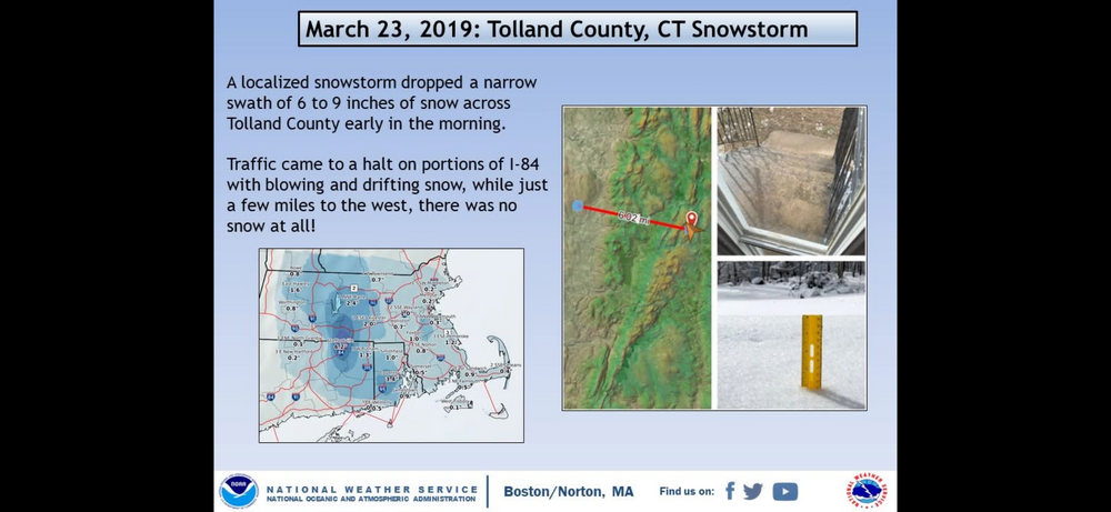
-
Completely overcast in DC (though NWS insists it's supposed to be "mostly sunny"). Haven't seen a single flake of snow, though.
-
New Years Day 2026 - 1st snows of the new year possible
The 4 Seasons replied to Baroclinic Zone's topic in New England
OKX followed suit no surprise for continuity amongst the CWAs -
WB 12Z EPS ensemble at range is cold enough: question is will it delivery anything but the same old same old for the later half of the month.