All Activity
- Past hour
-
details TBD but looks like a prolonged above average dewy stretch summer as it should be
-

E PA/NJ/DE Summer 2025 Obs/Discussion
RedSky replied to Hurricane Agnes's topic in Philadelphia Region
Nature is cruel it's dry and virtually nothing in the 10 day -

2025 Atlantic Hurricane Season
BarryStantonGBP replied to BarryStantonGBP's topic in Tropical Headquarters
-
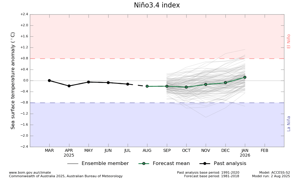
The BoM released 8/2/25 has -0.2 for ASO and then rises to near 0.0 for the winter: Colder boat needed here too probably.
-
Central & Eastern Pacific Thread
BarryStantonGBP replied to Windspeed's topic in Tropical Headquarters
Would be history if it happens -
-
 Sea breeze boundary w LI. Showers now at 250 pm
 -
2025 Atlantic Hurricane Season
BarryStantonGBP replied to BarryStantonGBP's topic in Tropical Headquarters
-
 There was an interesting article re: the subterranean blob of molten mantle moving south west under New England, aged 80 million years from when Greenland broke off. Maybe that is impacting the old fault lines?
 -
100% Grade-A Craftsman tool-chest.
-

2025 Atlantic Hurricane Season
Stormchaserchuck1 replied to BarryStantonGBP's topic in Tropical Headquarters
Barry obviously loves weather. He doesn't bother me. -

Central & Eastern Pacific Thread
LongBeachSurfFreak replied to Windspeed's topic in Tropical Headquarters
No storm has ever survived that far north of the Hawaiian islands. -

2025-2026 ENSO
40/70 Benchmark replied to 40/70 Benchmark's topic in Weather Forecasting and Discussion
Gonna need a colder boat- -
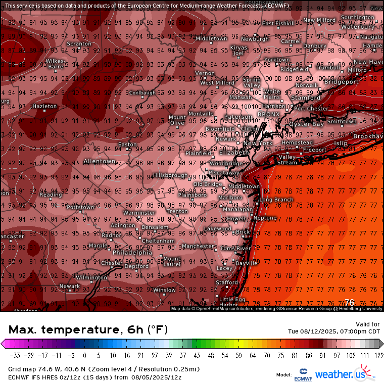
Days and days of 90+ on the euro.
-
2025-2026 ENSO
Stormchaserchuck1 replied to 40/70 Benchmark's topic in Weather Forecasting and Discussion
SOI has been solidly negative for the first time in a while, during the last 3 days. This has occurred with the ENSO subsurface cold pool no longer deepening.. the anomalies have moderated from -5c max to -3c max. 5 Aug 2025 1012.75 1014.10 -18.03 4.89 2.94 4 Aug 2025 1012.63 1014.25 -19.66 4.67 3.20 3 Aug 2025 1013.49 1015.10 -19.60 4.77 3.40 -

2025 Atlantic Hurricane Season
NorthHillsWx replied to BarryStantonGBP's topic in Tropical Headquarters
You can also choose to ignore certain posters in your profile settings. It has proven helpful on this site more than once. -
2025 Atlantic Hurricane Season
BarryStantonGBP replied to BarryStantonGBP's topic in Tropical Headquarters
I post model runs. -
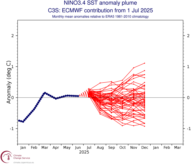
Thanks, Mitch. This is slightly cooler than the July run, which had ~-0.1 (ASO through NDJ): This new one has ~-0.3 for August and has trimonths through DJF at ~-0.2. So, it’s ~steady from now through winter though it still tends to have a bit of a warm bias even this late. The implied RONI low would be ~~-0.5 ignoring this warm bias. @Stormchaserchuck1
-
another 2.7 quake in the NYC area.. 2 in a few days,, something bigger coming?
-
 Looking like models want to bring back the 100° heat for spots like Newark next week before the 15th. Be interesting to see if this matches recent history since 1994 of no 100s after August 15th. But wouldn’t be surprised if we eventually end up getting late August into early September 100° heat again. Especially since the model runs over the last 5 days have really dried out the forecast pattern again after the locally flooding rains last week. Not a great precedent to set for this much warmer climate if we can continue to reload 100° heat following these flash flood events. Past instances of these flooding events usually came after the 100s and we didn’t get follow up 100s. I was thinking as recently as a few days ago that maybe only a few warm spots in NJ could challenge 100° again. But the latest guidance is suggesting that 100° heat could also be possible in places like Queens. So unfortunately we may be entering an even warmer phase of these already warmer to record warm summers since 2010. The posters that were suggesting that we could see a mid-August heatwave at least rivaling the one back in late July may turn out to be correct. Good call on your part.
-
 True, I've been keeping my pool open until the 1st week of Oct. I have to use the heater due to the cooler nights, but worth it then to take a dip after work or on weekends.
 -

2025 Atlantic Hurricane Season
NC US Geological Survice replied to BarryStantonGBP's topic in Tropical Headquarters
Mods, time to throttle this guy. We are likely within 10 days of significant effects to land in the NW Atl Basin. The seriousness has elevated and the maturity in the thread needs to step up. -
Moregarbage desperately trying to hang on. Need a grand slam pinch hitting to win this one I think.
-
Hit up the old port in Portland for some fine seafood, Port Hole Restaurant, Jay's Oyster Bar Or (Dimillow's Floating Restaurant, Bit Pricey Though), Head down to Old Orchard Beach in Scarborough or you can canoe the salt marsh on the way into there.