All Activity
- Past hour
-
GFS = scattered showers both days east of the mountains Euro = scattered showers Saturday and wetttt sunday
-
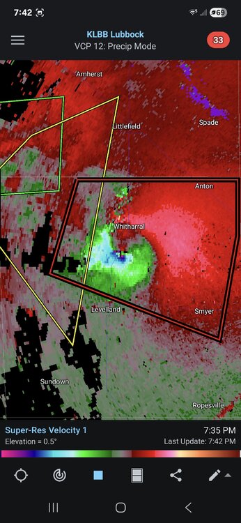
we need this! TXC219-303-060145- /O.CON.KLUB.TO.W.0033.000000T0000Z-250606T0145Z/ Lubbock TX-Hockley TX- 754 PM CDT Thu Jun 5 2025 ...A TORNADO WARNING REMAINS IN EFFECT UNTIL 845 PM CDT FOR WESTERN LUBBOCK AND EAST CENTRAL HOCKLEY COUNTIES... At 753 PM CDT, a confirmed tornado was located over Reese Center, or 6 miles west of Lubbock, moving southeast at 45 mph. The West Texas Mesonet Station at Smyer gusted to 109 mph at 746PM.
-
Nice. Hopefully some hundos in the near future
-
Picked up a decent .43" today. A far cry from the 1-2" predicted.
-
So Saturday looks not good?
-
-
Most in the know do and know . ACATT are worried
-
I do think this will be a pretty hot one
-
Man we finally start getting consistent warmth and people want to start going back the other direction. No thank you.
-
For another depression winter? Enjoy the warming climate, it’s the only warming climate you got. I love embracing summer. Need to adjust.
-
The Oaks Golf Links in Somersworth, NH is a bear of a course. Fastest greens I’ve played this year by far. The course frustrated a lot of good golfers this past Monday. Off the tee, you almost don’t have to hit it over 250 if at all because most fairways run out at that number. It’s real defense are small, well protected greens. It was tough to confidently hit into them when most of them were protected by a bunker in front and a cliff off the back.
-
Just the tip of what is to come
-
Strongly recommend Lake Sunapee Country Club if you get the chance. (Played it today) Donald Ross design. Huge fairways. Decent sized greens. Pretty simple track if you are playing well. Hardest hole is definitely the 235+ yd par 3 12th. Which plays up hill. I had to hit a full 3 wood to get up there. And we were playing 1 up from tips.
-
You are the opposite of those people who challenge themselves to not turn on the heat in winter.
-
It was F’ng hot at Lake Sunapee Country Club today. And Oh… most views looked like this.
-
hit 90.2 today.. I think we average 1 to 3 of them a year here so hopefully its the last
-
PA Storms to fizzle but cloud debris may linger into tomorrow
-
Highs: TEB: 90 EWR: 90 New Brnswck: 89 LGA: 88 NYC: 87 PHL: 87 BLM: 86 TTN: 86 ACY: 84 ISP: 83 JFK: 81
-
It definitely has that classic, mid-Atlantic swampy feel outside, I'm assuming in part due to how saturated the ground is. Nothing like the last few years.
-
Tomorrow will be another warm day with the temperature rising into the lower and perhaps middle 80s. A shower or thunderstorm is possible during the afternoon or evening. The weekend will turn somewhat cooler with high temperatures returning to the 70s. Showers and thundershowers are possible during the weekend. Rainfall amounts should generally be light except where scattered locations see heavier thunderstorms. The ENSO Region 1+2 anomaly was +0.8°C and the Region 3.4 anomaly was -0.1°C for the week centered around May 28. For the past six weeks, the ENSO Region 1+2 anomaly has averaged +0.17°C and the ENSO Region 3.4 anomaly has averaged -0.07°C. Neutral ENSO conditions will likely continue through at least mid summer. The SOI was +7.45 today. The preliminary Arctic Oscillation (AO) was +1.874 today.
- Yesterday
-
I want a repeat of July 1993 / July 2010
-

Mid to long range discussion- 2025
UnionCountyNCWX replied to wncsnow's topic in Southeastern States
Surprised there's not much chatter about Saturday yet. Looks like it could be an interesting afternoon accross a good portion of the SE. -
Nah, Give me a CAT3 or higher. /// Give me a 24hr. Blizzard You'd love Floridah WIZ
-
5 pm update Central Park reached 87 and the AQI peaked at 161 which is bad for EVERYONE. They said that the Canadian wildfire smoke wasn't just in the upper atmosphere but made it down close to the ground too which added to the problem with ground level ozone which we had since yesterday. My high was 85 here and 91 inside my house so I turned on my a/c at 4:30
-
I just saw that the SST near Montauk are already up to 73! No wonder Montauk was at 78 degrees at 4 pm! It's warmer there than it is in south NJ (69) or Fire Island (65).


