All Activity
- Past hour
-

2026-2027 El Nino
snowman19 replied to Stormchaserchuck1's topic in Weather Forecasting and Discussion
- Today
-
Vortex PT in RI today? https://www.facebook.com/reel/1413402380828852
-

Potential Sever Weather Outbreak 4/27/2026
TheNiño replied to pen_artist's topic in Lakes/Ohio Valley
00z HRRR came in hot for eastern Missouri and central Illinois. Looking like a more limited risk for LOT but things down south are looking quite spicy Edit: No moderate risk on the new day 1. Is my weenie certificate mailed to me or do I need to pick it up in person? -
Hopefully we can get a decent rainfall tomorrow morning with the crapvection, as the afternoon stuff looks like a non-event for this area. Been a nice and rainy past month or so, but sort of a drier stretch coming up for the next few weeks. Still have ground to make up for that abysmal Aug-Feb stretch of dry weather.
-
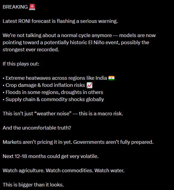
Not the chart (which you already reposted with a Tweet 2 posts before this one btw), but the entire content of the tweet leading up to it Every line containing the hallmarks of AI, completely synthetic fluff packaged into a tweet format. I sincerely hope you don't follow this guy and just found them by searching up keywords like "Super El Nino", but I also wouldn't put it past you.
-
A -10/100 kind of day, just gross.
-
The 0Z RRFS is pretty aggressive with discrete supercells as well.
-

Potential Sever Weather Outbreak 4/27/2026
MidwestChaser replied to pen_artist's topic in Lakes/Ohio Valley
-

Potential Sever Weather Outbreak 4/27/2026
Chinook replied to pen_artist's topic in Lakes/Ohio Valley
This is starting to look like a large amount of supercells getting going tomorrow. In the Convective Chronicles Youtube channel, Trey mentioned that tomorrow will fits the Omega Project definition of a fast-moving 500mb jet streak going into a zone of potential tornadoes (Broyles Et. Al.) -

E PA/NJ/DE Spring 2026 Obs/Discussion
KamuSnow replied to PhiEaglesfan712's topic in Philadelphia Region
That's not unreasonable. -

Potential Sever Weather Outbreak 4/27/2026
RCNYILWX replied to pen_artist's topic in Lakes/Ohio Valley
Ideally the ENH gets carved out of a large chunk of the LOT CWA. There just isn't enough confidence to warrant it up into the Chicago metro, with the distinct potential for the elevated late AM thru early afternoon convection to force the effective front well south. It would be tough to recover sufficiently for a meaningful severe threat with north and northeastward extent. This looks like a spatially modulated but still higher end setup where substantial air mass recovery is most likely to occur, which appears to be eastern MO eastward into adjacent sections of IL. One of our forecasters at work drew up a reasonable target area for the most appreciable sig tor threat, possibly worthy of a 15% contour. -

2026-2027 El Nino
Stormchaserchuck1 replied to Stormchaserchuck1's topic in Weather Forecasting and Discussion
Does anyone trade weather derivatives or is familiar with it? It's kind of frustrating that this May pattern was predictable far in advance -- March was 2nd most +NAO on all of records, going back to 1950. The +2 month, following May's had a strong below average temp signal: So here we are in May, and it's verifying Sometimes in weather forecasting there are these strong leads -- and I would like to be able to use knowledge to increase capital. PNW warmth was very predictable from pre-El Nino year May's, a composite that has been working out every month since November 2025: -
CoastalWx longing for this again? He knows what this is like when he lived in Dorchester! After he had calmed down, he got mad b/c they couldn't fix the messed up transformer arcing outside! https://x.com/AdamLucioWX/status/2048255300302438510
-

Potential Sever Weather Outbreak 4/27/2026
Chicago916 replied to pen_artist's topic in Lakes/Ohio Valley
Still looks like models are overdoing ongoing precipitation. Gonna have to closely watch what the storms in KS do further east I'd think. -

Potential Sever Weather Outbreak 4/27/2026
cyclone77 replied to pen_artist's topic in Lakes/Ohio Valley
Central and southern IL still in the game, and into Indiana later on. Northern IL looks pretty cooked to me. -

E PA/NJ/DE Spring 2026 Obs/Discussion
MGorse replied to PhiEaglesfan712's topic in Philadelphia Region
I think that is more subjective. I tend to stay away from using those types of phrases. -

Potential Sever Weather Outbreak 4/27/2026
CheeselandSkies replied to pen_artist's topic in Lakes/Ohio Valley
00Z HRRR: We're so back? -
And a shovel if Scott gets his way!
-
Sure does. Sat outside for 7 hours watching my kids softball games. Cold, windy, damp. Had some sun for like 45 mins then it disappeared and it got cold again haha. On the plus side they won the tournament. I'm sure I will be complaining about sitting in 95 degree humid trash air in a month though!
-
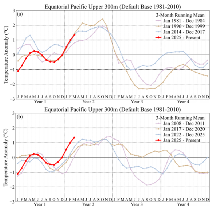
Tracking 1997 closely in the upper ocean. Currently well above recent non-super El Nino years. Chart from James Hansen as of March. https://mailchi.mp/caa/super-duper-el-nino
- Yesterday
-
The "worst" in this case driest model is usually correct in the mid Atlantic.. Anyone know when the NAM will finally be put to bed?
-
Man, I don't want a cool May. It's also our most cloudy month of the year, so below average also means more clouds
-
Is this like comparing sugar to shit?
-
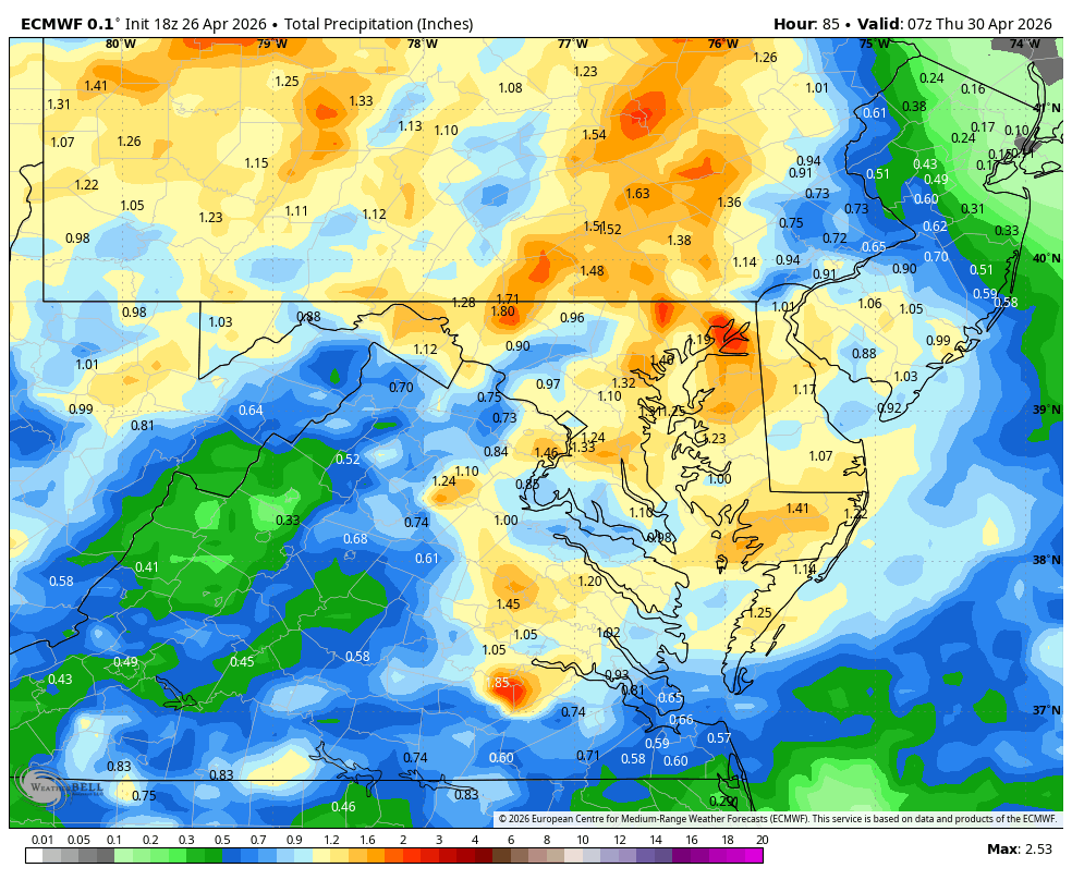
WB 18Z EURO for mid week.