All Activity
- Past hour
-
Yup, end of the week looks like some mid-80s possibly higher in hotspots but nothing sustained. So long as it doesn't rain I'm happy.
-
3k NAM says enjoy the dry weekend. Let’s go team hrrrrr!
-
Too many people in my neighborhood have poured chemicals in their lawn. We're the only property that has them anymore in our street.
-
For the first time in 14 months, Virginia is drought free.
-
we are right on the edge of heat at times. So maybe it’s a day or two of warmth followed by fropa and N to nE winds while NJ south roasts.
-
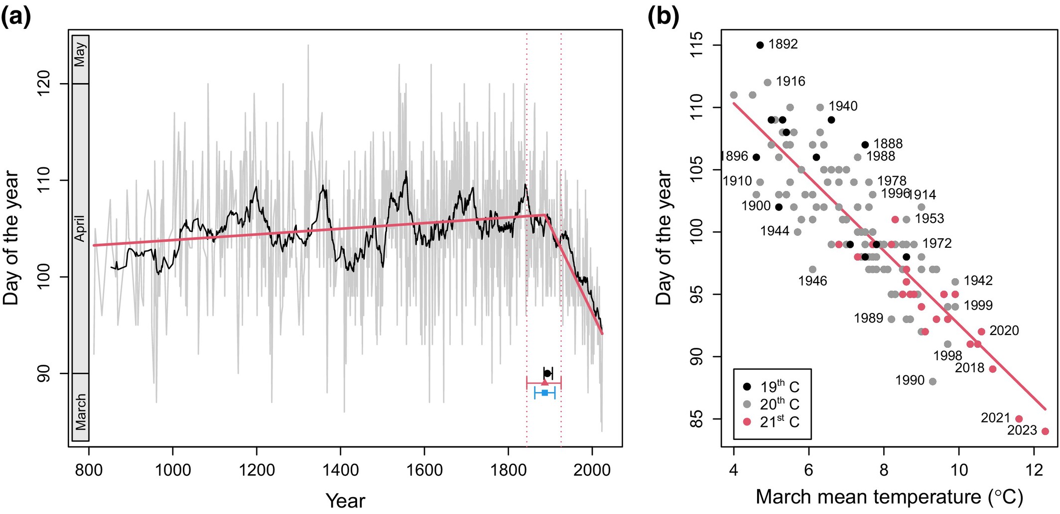
New paper analyzing the flowering date of Kyoto Cherries. Warming began to impact cherry flowering around 1890. Per the paper, urbanization and changes in cultivation are unlikely to have had much impact at that time. https://nph.onlinelibrary.wiley.com/doi/10.1111/nph.70268

-
You could be very well right on that.
-
Of course I'm not a college trained meteorologist, but I have a feeling this pattern is going to keep going for most, if not, the entire summer.
-
-
-
Hazardous Weather Outlook...UPDATED National Weather Service State College PA 430 AM EDT Fri Jun 13 2025 PAZ017>019-024>028-033>036-056-057-059-063>066-140830- Clearfield-Northern Centre-Southern Centre-Cambria-Blair-Huntingdon- Mifflin-Juniata-Somerset-Bedford-Fulton-Franklin-Perry-Dauphin- Lebanon-Cumberland-Adams-York-Lancaster- 430 AM EDT Fri Jun 13 2025 This Hazardous Weather Outlook is for central Pennsylvania. .DAY ONE...Today and tonight. Showers will become numerous later this afternoon and tonight along with isolated thunderstorms, that will bring up to one inch of rain in some places by sunrise Saturday. The main impact of the rain later today and tonight will be to prime the ground for potential flooding from additional showers and storms this weekend into early next week. .DAYS TWO THROUGH SEVEN...Saturday through Thursday. Several rounds of locally heavy rainfall could result in an increasing threat for short duration flooding Saturday and Sunday. .SPOTTER INFORMATION STATEMENT... Spotters are encouraged to report significant hazardous weather.
-
- Today
-
Was talking to the farmer yesterday that farms our land. He said they are behind on planting. He said they couldn't plant our neighbors 1.5 acre section because of it being too wet. They are a month behind on planting our farm. Now our farm was the last to be planted. He also said they might have to replant soybeans that were planted this year in cornfields from last year, I asked why, he said slugs eat the seed because it was so wet and cold. The perfect weather for slugs to thrive.
-
Min 51.1° Feels chilly, but not too far below normal.
-
High of 88 yesterday.
-
Every global model suite is showing close to 2 inches of qpf through next Friday.
-
-
If you’d actually look you’d see
-
Skubal dominated, which was expected with the Os inconsistent offense.
-
Flood Watch National Weather Service Baltimore MD/Washington DC Issued by National Weather Service State College PA 345 AM EDT Fri Jun 13 2025 DCZ001-MDZ013-016-017-504-VAZ037>039-050-051-053>057-502-527-131545- /O.NEW.KLWX.FA.A.0011.250613T2200Z-250614T0600Z/ /00000.0.ER.000000T0000Z.000000T0000Z.000000T0000Z.OO/ District of Columbia-Prince Georges-Charles-St. Marys-Central and Southeast Montgomery-Albemarle-Greene-Madison-Orange-Culpeper- Fairfax-Arlington/Falls Church/Alexandria-Stafford-Spotsylvania- King George-Southern Fauquier-Central and Southeast Prince William/Manassas/Manassas Park- 345 AM EDT Fri Jun 13 2025 ...FLOOD WATCH IN EFFECT FROM THIS EVENING THROUGH LATE TONIGHT... * WHAT...Flash flooding caused by excessive rainfall is possible. * WHERE...Including the following , District of Columbia, including the following areas in Maryland, Central and Southeast Montgomery, Charles, Prince Georges and St. Marys, and including the following areas in Virginia, Albemarle, Arlington/Falls Church/Alexandria, Central and Southeast Prince William/Manassas/Manassas Park, Culpeper, Fairfax, Greene, King George, Madison, Orange, Southern Fauquier, Spotsylvania and Stafford. * WHEN...From this evening through late tonight. * IMPACTS...Excessive runoff may result in flooding of rivers, creeks, streams, and other low-lying and flood-prone locations. * ADDITIONAL DETAILS... - Showers and thunderstorms will increase in coverage late this afternoon through this evening. Some thunderstorms will contain heavy rainfall, with rainfall amounts around 1 to 3 inches possible within an hour or two. Storms may also train over the same areas, causing the possibility for locally higher amounts around 4 to 5 inches of rain within a few hours. Heavy rainfall in a short period of time combining with already saturated soils means that creeks and streams may rapidly rise out of their banks along with the potential for flash flooding in urban areas. - Please visit www.weather.gov/safety/flood for flood safety and preparedness information
-
Let’s bring those 60s down on the cape+south coast up a few ticks. Come on, just a little nudge!
-
 Falian6029 joined the community
 -
Gonna call this the year of the east wind
-
Nurse dewy is…
-
You stomp on it?