All Activity
- Past hour
-
Jelly
-

December 2025 regional war/obs/disco thread
WinterWolf replied to Torch Tiger's topic in New England
Ops gonna op…take away is, the signal for 12/23 is decent. And there will be action/chances. Hope we are on the right side. -

December 2025 regional war/obs/disco thread
weathafella replied to Torch Tiger's topic in New England
AI looks much less torchy for gfs. Skynet has a nice borderline warning event on the 28th but you’re too far south verbatim. -
can't believe it's been nearly 11yrs
-
So I have to look, but from 1/24 to 2/24 we had over 100” here. Won’t see that again.
-
I agree that wind events are more common in La Ninas. But the current pattern we've been stuck in for the past 10 days or so is atypical, with a parade of super-juiced, subtropical atmospheric rivers hitting the PNW, which is what's leading to this crazy westerly flow across the continent. It's leading to record warmth across the West, meanwhile up north they're in the deep freeze. Places like Juneau, AK are having one of the coldest Decembers in many years.
-
51 / 36 here.
-
Yeah that nice event after the 96 blizz was max pack here.
-

December 2025 Short/Medium Range Forecast Thread
Carvers Gap replied to John1122's topic in Tennessee Valley
Unfortunately, the Aleutian Ridge has been a staple of recent past Nina winters - the big red ball on 500 maps. If forces a Rex block. Models have a very difficult time "knowing" when it ends - much like the NAO. I don't think there is a lot of data in that area, and that can be a problem. It seems like the Aleutian Ridge has a tendency to disappear with little notice, and the trough kicks almost immediately eastward. Those ice and snow storms that middle and west Tenn have experienced occurred when that Aleutians Ridge pattern relaxed. It seems to me that usually occurs between the first and third weeks of January. I know some think the trough retrogrades and does not come back. If the NAO goes negative, that could balance things out. We lacked the NAO w/ recent analogs where the trough pulled back, and wouldn't budge. There is a lot of uncertainty going forward. I generally like uncertainty, because that leaves room for crazy weather. In winter, that could be anything from severe (which I don't like) to winter storms. I think the key going forward is the NAO going negative. It is the ingredient in many EC storms. That doesn't necessarily help you all just to the west...but it can force sliders in addition to coastals. -

December 2025 regional war/obs/disco thread
SouthCoastMA replied to Torch Tiger's topic in New England
I will accept a 12/27 torching..which seems evident on most of the 12z models..if we can maximize 12/23 -
Not even close to a major city, but Machias Maine, at 20' elev, had 106.3" from Jan 25-Feb 23, 2015. Meanwhile in the (usually) snowier foothills, we had 52.5" during the same period. We had 60.1" in 31 days, Feb 10-Mar 12, 2005. In Fort Kent, tops was 63.0" from Dec 7, 1976 thru Jan 6, 1977. December alone had 61.5".
-
December 2025 Short/Medium Range Forecast Thread
Carvers Gap replied to John1122's topic in Tennessee Valley
The 12z GFS has pretty massive feedback issues. I don't really have a problem w/ a trough off the West Coast - that happens. The 5-7 days of endless vortices spinning up just doesn't make sense. Just when I thought it had that worked out....it is right back to it. The 12z GFS really doesn't have a -NAO either. We need the NAO to establish HL blocking and force the issue I think. The GFS is just way off on its own by 300. -
.50” so far .
-

December 2025 regional war/obs/disco thread
40/70 Benchmark replied to Torch Tiger's topic in New England
I still suspect the blocking is being overdone, but hopefully we deviate a bit from my seasonal. -

2025-2026 ENSO
donsutherland1 replied to 40/70 Benchmark's topic in Weather Forecasting and Discussion
It will be interesting to see how things evolve. Since 1980, December PNA- cases have been followed by January PNA+ cases. Prior to 1980, December PNA- cases were generally followed by January PNA- cases. It is possible that the less stable PNA state is, at least in part, a result of Arctic amplification.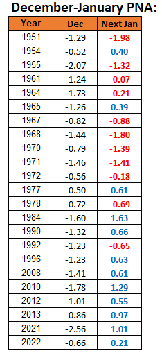
-
Actually a decent illustration of how mild it will get if we don’t get good blocking.
-
-
Yeah and we had about 11-12” of dense snow in that one. It wasn’t fluff. It was cold/dry but like very dense. Made the pack beyond obscene.
-

Mountain West Discussion
mayjawintastawm replied to mayjawintastawm's topic in Central/Western States
My rooftop PWS is also not high enough to register wind speeds accurately, but it was up to 33 MPH several times last night and in the past its readings are roughly 40-50% of what the nearby airport records so I can safely say we had 60 mph gusts, which are the highest recorded since we've lived here (15 years). Fortunately we had a lot of tree work done this year and no damage other than a holiday dinosaur in the front yard that broke into pieces. We have friends in Yuma County who were absolutely terrified by the fires last night, all sparked by downed power poles when the wind gusts topped 70 mph with the frontal passage around 9 PM last night. Fortunately, between farmers with tractors and disc plows and what other ground-based resources they had, they were able to contain all but one within a few hours. The threat isn't over yet, but neither do they have power yet. -
December 2025 regional war/obs/disco thread
40/70 Benchmark replied to Torch Tiger's topic in New England
I managed like 5" of slop in that. -
GFS looks fun, if you want to escape any snow past the 23rd/24th "event".....Sheesh, I know it is the OP Post 144 hrs, but seriously that is hideous
-
1/12 hurt. Rain after an inch of slop.
-
December 2025 Short/Medium Range Forecast Thread
Carvers Gap replied to John1122's topic in Tennessee Valley
The reason I posted these is to illustrate that sooner or later the NAO is gonna put the squeeze on this pattern. The NAO is a trump card as is the EPO. If one is in play, that is a good thing regardless of the MJO phase, etc. The tendency is for the trough to find its way eastward when the NAO is present on modeling. The 12z GFS shows what happens when it is late to the party. The Canadian suite is most definitely the fastest flip. -

December 2025 regional war/obs/disco thread
Damage In Tolland replied to Torch Tiger's topic in New England
Fffftttts…? -
December 2025 regional war/obs/disco thread
40/70 Benchmark replied to Torch Tiger's topic in New England
Yea, 1996 had a secondary jack over ORH CO....spread the wealth more. Bit like 1994 in the regard.


