All Activity
- Past hour
-
Any TC rain hits? Any early season interior high terrain snow acc late in the month? Do we experience above normal rainfall for October?
-
Good morning Torch Tiger. I can understand the sentiment. As for Mr Epstein, I believe it’s best that he counts his blessings and keep sharing the photos. As always ….
-

September 2025 OBS-Discussion centered NYC subforum
LibertyBell replied to wdrag's topic in New York City Metro
Bob in 1991 came very close to making landfall at MTP and would have had more of an impact than Gloria did. Based on news reports at the time, I distinctly remember Gloria made landfall in Western Suffolk County, not near JFK airport. It didn't matter though because the eye was extremely large and covered all of us and there was no backside except for some gusty winds and partly cloudy skies. -
September 2025 OBS-Discussion centered NYC subforum
LibertyBell replied to wdrag's topic in New York City Metro
Thanks Don, it looks like September 1983 started to cool off around the 22nd, just in time for Fall -

Potential Tropical Cyclone Nine
donsutherland1 replied to WxWatcher007's topic in Tropical Headquarters
This paper likely explains why they are leveraging AI: https://alixsoliman.com/wp-content/uploads/2025/01/nature_deepmind-weather-ai_in-print_alix-soliman.pdf -
LOL. AT 11:00 A.M. they mention NOAA AIGEFS in the Humberto discussion. First mention of another AI guidance I've seen.
-
September 2025 OBS-Discussion centered NYC subforum
LibertyBell replied to wdrag's topic in New York City Metro
1985: Hurricane Gloria today makes landfall on western Long Island, New York with sustained winds of 85 mph. (gusts to 115 mph.), moving at 35 mph., Pressure 28.37 inches or 961 mb. and a storm surge of 4- 7 feet above Mean Tide. Hurricane Gloria was one of the most intensely reported events of the 1980's. Gloria hit New York and Connecticut as a moderate hurricane in September 1985. Although Gloria was not a major hurricane when it struck Connecticut, it was significantly more damaging to Connecticut than Hurricane Belle (1976) and Hurricane Donna (1960). Gloria at one time had a central pressure of 919 mb (27.13 in.), and sustained winds of 150 mph. - making Gloria almost a category five hurricane. At this time, Gloria was one of the largest and most intense cyclones to ever threaten the middle and north Atlantic states in several generations. Gloria brushed the North Carolina Outer Banks near midnight on September 27, with sustained winds of 105-mph and a central pressure of 27.83 inches (942 mb). The Diamond Shoals light-tower sixteen -miles off the North Carolina coast, recorded sustained winds of 98-mph with gusts to 120-mph. Gloria continued to accelerate northward off the eastern US coast brushing the coast of Virginia, Maryland, Delaware, and New Jersey with hurricane-force gusts. Gloria finally crossed the coast of the United States mainland near western Long island, New York about 10-miles east of Kennedy International Airport. Passing over central Long Island, Gloria crossed the Connecticut coast near Bridgeport about 40-minutes later with sustained winds of 80-mph. Weird, I remember it as making landfall between Babylon and Bayshore in Suffolk County, it did a NE turn once it was level with Monmouth County and veered a bit to the east from here. This is all academic and the exact landfall point does not matter since the eye was huge and covered the entire island when it crossed here. There was no backside either, just partly cloudy skies and gusty winds, all the rain was on the front side. -
September 2025 OBS-Discussion centered NYC subforum
LibertyBell replied to wdrag's topic in New York City Metro
Oh I thought you got it from Microcenter lol, where did you get it from? -

Potential Tropical Cyclone Nine
Maggie Valley Steve replied to WxWatcher007's topic in Tropical Headquarters
TD 9 has formed via the 11AM NHC Update. -
I understand the NHC has its hands full, but 125 knots is too low.
-

E PA/NJ/DE Autumn 2025 Obs/Discussion
JTA66 replied to PhiEaglesfan712's topic in Philadelphia Region
I was in college and had a part time job at a supermarket. The night Gloria hit, I had the 6 to midnight shift. I had to round up all the shopping carts. I made a “raincoat” out of a Hefty trash bag. Drove back to school with branches coming down. Next day we played a mud football game against the girls. -
(002).thumb.png.6e3d9d46bca5fe41aab7a74871dd8af8.png)
Central PA Fall Discussions and Obs
ChescoWx replied to ChescoWx's topic in Upstate New York/Pennsylvania
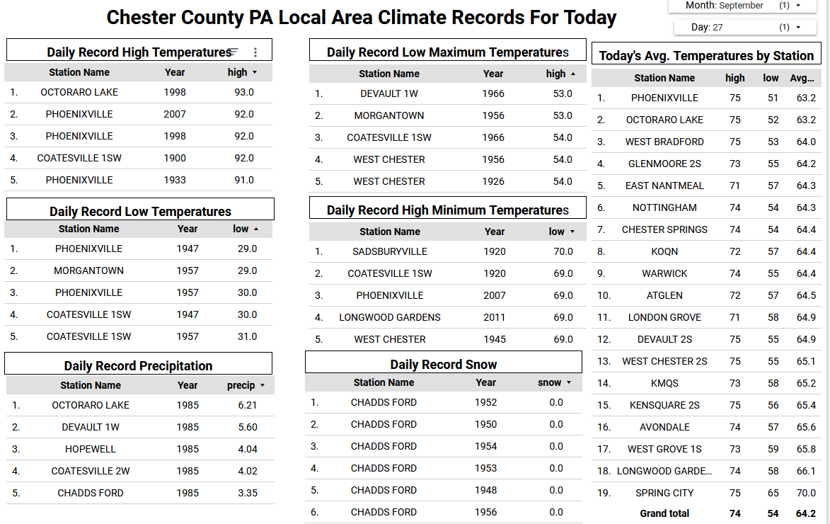
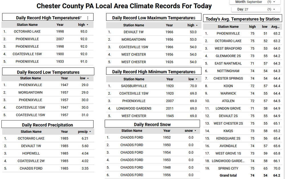
Any morning sun will fade behind clouds this afternoon. Some showers should start overspreading the area from south to north after 7pm this evening. Most spots across Chester County could see between 0.25" to 0.50" of rain. The sun returns tomorrow with continued above normal temperatures in the upper 70's. This will continue through early in the work week before we start a big cool down by the middle of the week. Of note you will see in the climate records below that 40 years ago today back in 1985 we experienced heavy rain across the area as a result of Hurricane Gloria.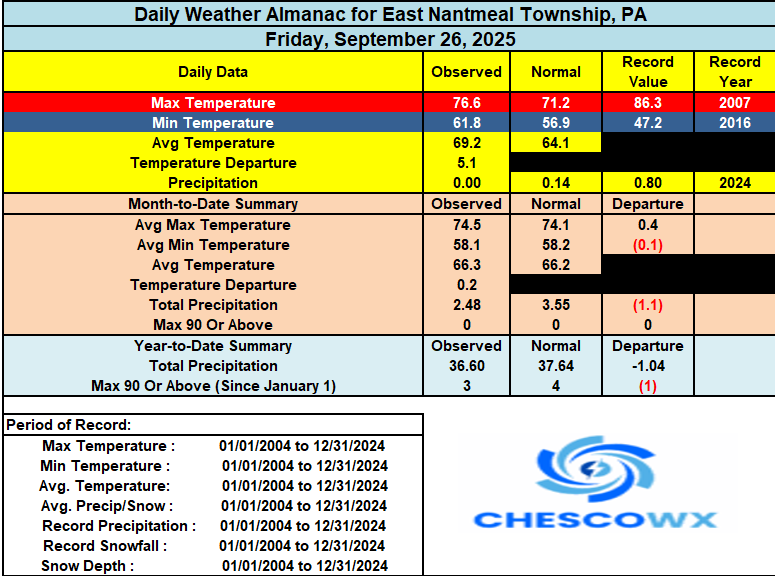
-
6z EPS has the latter scenario.
-
It is a really interesting how this evolves. As Humberto moves around the Atlantic ridge it "tugs" on Imelda by causing a path of least resistance. But Humberto is far enough along in the recurve that it accelerates north and allows the ridge to build over Imelda. How exactly this plays out determines how far offshore Imelda gets, which in turn affects how close it can get to the US coast when it gets picked up by the next trough. The 6z GFS pulls it pretty far out to sea, so any landfall is in the Canadian maritimes or not at all. The 6z Euro leaves it off the Carolina coast through 144, which is markedly different form the 0z run. The 0z GEM eventually takes it into New England! Is there a win for us? Very unlikely. We'd need for it to be left behind and just churn over the Gulf Stream and then have a trough dig far enough to bring it in to us. I'd be more optimistic about this in later October, but it seems like a pipe dream here.
-
E PA/NJ/DE Autumn 2025 Obs/Discussion
ChescoWx replied to PhiEaglesfan712's topic in Philadelphia Region
Any morning sun will fade behind clouds this afternoon. Some showers should start overspreading the area from south to north after 7pm this evening. Most spots across Chester County could see between 0.25" to 0.50" of rain. The sun returns tomorrow with continued above normal temperatures in the upper 70's. This will continue through early in the work week before we start a big cool down by the middle of the week. Of note you will see in the climate records below that 40 years ago today back in 1985 we experienced heavy rain across the area as a result of Hurricane Gloria.
-

September 2025 OBS-Discussion centered NYC subforum
winterwarlock replied to wdrag's topic in New York City Metro
Nah I mean usually by mid September brings up 1-3 days with sun and mid 60s before warming back up again -
2025-2026 Fall/Winter Mountain Thread
Maggie Valley Steve replied to Buckethead's topic in Southeastern States
12Z Track guidance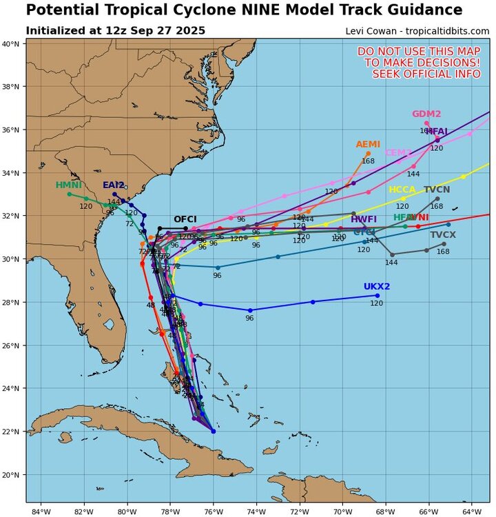
-
Would love to hear from a met about how the southern end of the wave axis managed to cling on for multiple days while being physically separated from the northern end.
-
Squirrels have been around my yard with those for a couple of weeks now. Always a sign of fall’s arrival.
-
Imelda has formed
-
I'm still not seeing anything in the recon plans regarding flying into Humberto. As far as I know/remember, they always fly into hurricanes within range, as Humberto clearly is.
-
Agree. I was surprised when I saw AI in their discussions earlier this year. I'd keep it "in house" for a few years to establish some kind of track record. So new and unproven. They mention Google but nothing about any of the other AI guidance available. I find that kind of odd as well.
-
Damp morning... Up to 0.57 for the morning....Good rebound for the month the last week or so...
-

September 2025 OBS-Discussion centered NYC subforum
SACRUS replied to wdrag's topic in New York City Metro
76 / 62 - Today
-
I have mixed opinions on the NHC utilizing DeepMind during the infancy of the AI revolution. It should absolutely be used as a tool, but Im not sure we are at the point where it should be used as a weighted metric in forecast discussions with the public. Model fatigue is a very real thing.


.thumb.jpg.5af6c8520bd26ab0d13e24b2747484e1.jpg)