All Activity
- Past hour
-
Yeah that westward trend has put us from toucans, to shots of cold, to having room to dig these shortwaves and curve something up the coast at our latitude and a little blocking will help with that. I think I saw a fantasy run yesterday in the extended that retrograded at our latitude as well. Everyone up here starts getting anxiety now when the NAO starts getting too negative, but I feel like this may be a time we’d want it…unless everyone is happy with quick hitting light-mod events.
-

December 2025 regional war/obs/disco thread
Cold Miser replied to Torch Tiger's topic in New England
You forget my measly 1.25. -
You would think something would work out.
-
not bad
-

2025-2026 ENSO
40/70 Benchmark replied to 40/70 Benchmark's topic in Weather Forecasting and Discussion
I would take a deep and quick plunge right into the Merrimack....I just can't anymore. -
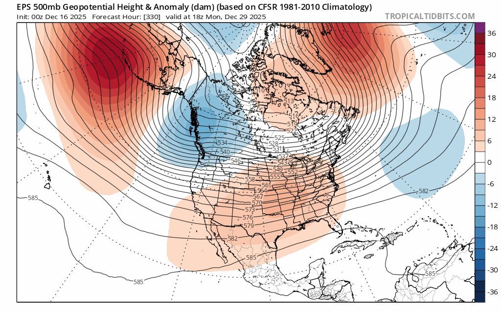
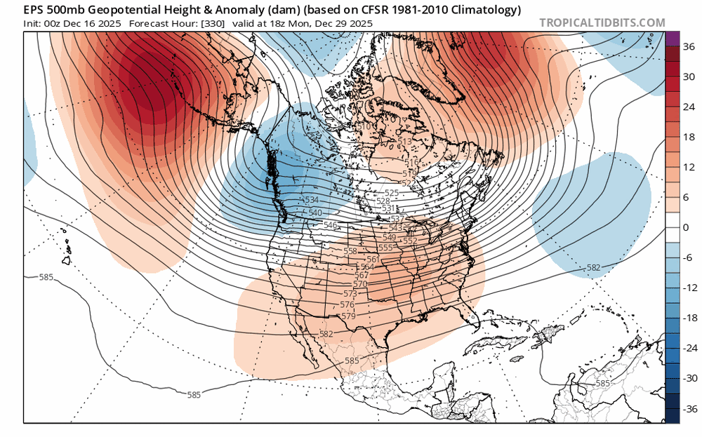
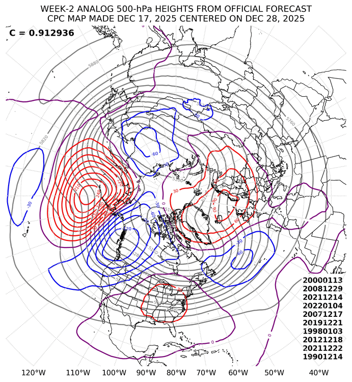
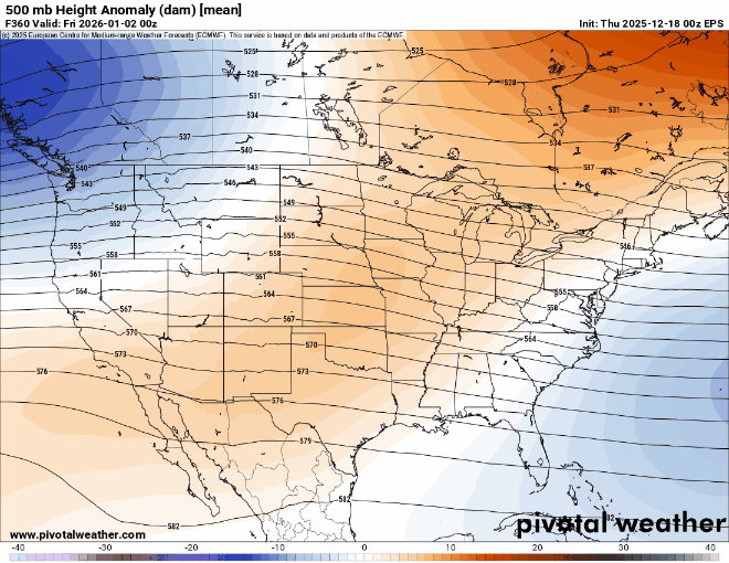
The 500 mb analogs composite has the ridge axis a little further East. Probably related to how anomalous the ridge is centered just to west . It’s shifting eastward from where it has been in the West for the first part of month. Maybe this is why the AIFS has the ridge centered further east than the EPS.
-
@H2Obringing it
-
December 2025 regional war/obs/disco thread
40/70 Benchmark replied to Torch Tiger's topic in New England
Yea, about as interesting to see as my first colonoscopy next month. I will say something should work out soon.......it's getting to the point climowise where we are going to be destined for another shitty season if it doesn't snow significantly in short order, and I just don't envision that for this season. -
WB 6Z AI for NY week
-
December 2025 regional war/obs/disco thread
40/70 Benchmark replied to Torch Tiger's topic in New England
That would send me right off the deep end....January 2011 worked out, but it seams like ever since deeply neg NAO has been just lights out around here. -
December 2025 regional war/obs/disco thread
40/70 Benchmark replied to Torch Tiger's topic in New England
Taking the reigns from Will on that now that he's a family man haha. Close enough for me....I have 3.75" and am just west of that 3.6". Nice job. -
Records: Highs: EWR: 64 (2023) NYC: 63 (1984) LGA: 63 (2023) JFK: 64 (1984) Lows: EWR: 13 (1953) NYC: -1 (1919) LGA: 16 (1953) JFK: 16 (1973) Historical: 1620: The Pilgrims landed at Plymouth, MA in a severe windstorm. (Ref. Wilson Wx. History) 1779: The first big snowstorm of the "hard winter" dumped 17 inches on New Haven, CT. (Ref. Wilson Wx. History) 1919: New York, New York: The Central Park temperature drops to one degree below zero F, the earliest sub-zero temperature in the city on record. A cold air mass brought record cold along the east coast. Other daily record lows for the date included: Burlington, VT: -13 °F, Syracuse, NY: -13 °F, Worcester, MA: -11 °F, Portland, ME: -10 °F, Rochester, NY: -7 °F, Boston, MA: -6 °F, Hartford, CT: -6 °F, Elkins, WV: -5 °F, New York (Central Park), NY: -1 °F, Philadelphia, PA: 4 °F, Baltimore, MD: 7 °F and Washington, DC: 10 °F. (Ref. Wilson - Additional Temperatures Listed On This Link) 1944: The powerful U.S. Third Fleet was still in the grips of powerful Typhoon Cobra December 17th and 18th. The encounter with the typhoon was more damaging to the Fleet than many battles with the Japanese. (Ref. Wilson Wx. History) 1957 - A tornado swept across Jackson County, Williamson County and Franklin County in southern Illinois killing eleven persons. (David Ludlum) 1981 - A heavy lake-effect snow blanketed the southern and southeast shores of Lake Michigan leaving up to 22 inches of snow at Valparaiso IND. (David Ludlum) 1983 - Record cold hit the north central states. At Havre, MT, the mercury plunged to a record reading of 34 degrees below zero. (Sandra and TI Richard Sanders - 1987) 1984 - A storm over southern California left up to 16 inches of snow in the mountains and upper deserts, with 13 inches reported at Lancaster. Edwards Air Force Base was closed, and Interstate 5 was closed from Castaic to the Tehachapis Mountains. (18th-19th) (The Weather Channel) 1986 - A strong winter storm, which developed off the coast of New Jersey and moved out to sea, lashed the northeastern U.S. with high winds, heavy rain, and heavy snow. The storm left snowfall amounts of up to 30 inches in Vermont, 24 inches in Massachusetts, and 20 inches in New Hampshire. The highest rainfall amounts approached four inches in southern New England, where winds gusted to 70 mph. (Storm Data) 1987 - A weakening storm moved into the Rocky Mountain Region producing six inches of snow at the Platoro Reservoir in the San Juan Mountains of Colorado. The storm then spread rain and drizzle across the Southern High Plains into the Middle Mississippi Valley, with thunderstorms over Texas. (Storm Data) (The National Weather Summary) 1988 - Warm weather prevailed in the central U.S. while cool weather prevailed across the eastern states. Sheridan, WY, with a record warm afternoon high of 68 degrees, was seven degrees warmer than Key West FL. (The National Weather Summary) 1989 - A winter storm moving out of the Great Plains Region spread freezing rain, sleet and snow across parts of the southeastern U.S. Freezing rain resulted in 170 auto accidents in the Memphis area during the evening hours. Unseasonably warm weather continued ahead of arctic cold front. Miami FL equalled their record for December with an afternoon high of 87 degrees. (Storm Data) (The National Weather Summary) 1998: Atlanta, GA recorded its latest first freeze on record while across the southwest desert, Palm Springs, CA set a record high with 86 °F. (Ref. Wilson Wx. History) 2006: High pressure off the Carolina coast, combined with strong upper level high pressure over the Yucatan Peninsula and a strong trough out west produced a warm southwest flow resulting in record high temperatures from the Mississippi Valley to New York State including: San Antonio, TX: 81 °F-Tied, Mobile, AL: 77 °F-Tied, Charleston, SC: 77 °F-Tied, Sterling (Dulles Airport), VA: 76 °F, Greenville-Spartanburg, SC: 76 °F-Tied, Richmond, VA: 75 °F-Tied, Washington, DC: 74 °F, Tupelo, MS: 74 °F-Tied, Chattanooga, TN: 73 °F, Baltimore, MD: 72 °F, Nashville, TN: 72 °F, Wilmington, DE: 71 °F, Atlantic City, NJ: 71 °F. (Ref. Wilson - Additional Temperatures Listed On This Link) 2009 - A monster snow storm affected the Mid-Atlantic and Northeast regions of the U.S. on December 18th through December 20th. The storm originated in the Gulf of Mexico and moved northward along the Eastern Seaboard, leaving behind heavy snow accumulations from North Carolina to Massachusetts. Impacts from this storm included the closing of major airports, interstate highways, and rail systems. Over 1,200 flights were cancelled at the three major airports in the New York City area, and hundreds of thousands of people lost power due to the storm. Seven people were reported killed across the Mid-Atlantic (source: Reuters). Over two feet of snow accumulation was reported in portions of North Carolina, Virginia, West Virginia, Maryland, New Jersey, and New York. At one point, the storm was over 500 miles in width, and affected 14 states and tens of millions of Americans (Source: AFP).
-
December 2025 regional war/obs/disco thread
40/70 Benchmark replied to Torch Tiger's topic in New England
Getting close to the point where I'm going to have to capitulate and adjust. I thought that signal may fade a bit, but it's becoming more emphatic. -
December 2025 regional war/obs/disco thread
40/70 Benchmark replied to Torch Tiger's topic in New England
It would probably be occluded....those flashy low pressures don't always equate to the prevailing assumption. -
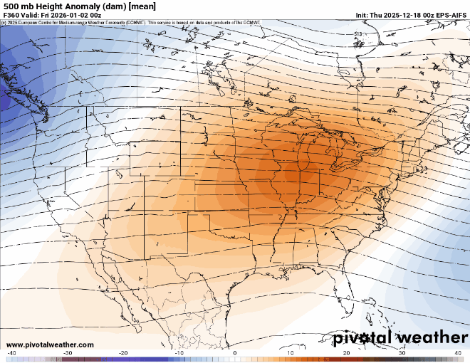
26 / 25 and on the way to (for some) the months warmest highs in the mid / upper 40s, perhaps some of the warmest get to 50. Rain by the morning Friday and a warm Southerly flow gets most into the mid 50s and some to 60, with around an inch of rain. Colder Saturday starts a bit of a back and froth colder - Sat, warmer - Sun , colder - Mon /Tue. Then warmer overall by Christmas through around the 29th/30th with the eneext storm threat in the 30-31 period. Ridge builds in the center with the cold just into the northeast which means a day or two very warm in the period and some quick pull back colder. Beyond there looks near normal.
-
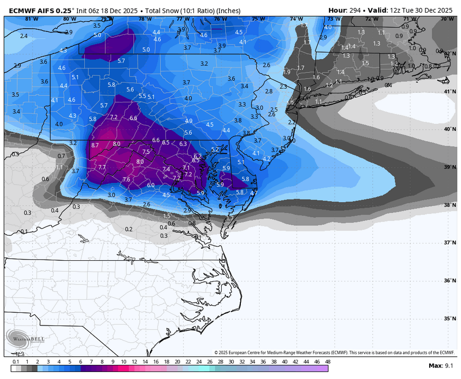
As usual great work and thanks again. Central park and LGA amounts stick out like a sore thumb lol.
-
There’s a lot of support for that look. La Nina (Jan), the EPS and GEFS forecasts for the NAO teleconnection are also aligned for deeply negative. The op runs signaling similar. Start worrying.
-

December 2025 regional war/obs/disco thread
Damage In Tolland replied to Torch Tiger's topic in New England
The big winds are about HFD SPD on east and inland.. away from the water -

December 2025 regional war/obs/disco thread
weatherwiz replied to Torch Tiger's topic in New England
yeah soundings are quite inverted there. Looked like though there could be room for a line with thunder/lightning. Probably the only way to draw down any good gusts. -
Very nice job. Can’t say I remember seeing this accumulation pattern before from a clipper. I didn’t notice any available models showing the NW heavy snow band from Sussex into Orange and surrounding areas.
-

December 2025 Short/Medium Range Forecast Thread
nrgjeff replied to John1122's topic in Tennessee Valley
Clippers are hard to get in southern Tenn. Northeast Tenn can benefit from them. Yeah a clipper can happen in Chinook but it'd be tough to get it down here. GaWx is right about the -NAO which could over-achieve northeast only - prolly more like NE USA. GaWx is a good follow even though mainly Southeast. Close enough his posts can be relevant here. Then I have to whine about how I miss clipper action growing up near KC. Felt like two storm tracks work, clipper and Colorado/SW low. Here it's gotta be near perfect with little margin for error. Guess that's what makes snow in the South special! -
I said about a week ago that if there is to be any ATL blocking it helps if it’s NAO because we need the road blocked closer to us than Norway. Gimme a jack knifed semi with 50/50 and that can buckle PAC flow enough
-
Cape will be inverted I think.
-
I wouldn’t worry too much this far out. Just real interesting to see. That subtle shift west in the central Conus ridge hopefully helps to keep systems from shunting south.
-
It matches the teleconnection forecast. Not good.