All Activity
- Past hour
-
chantelle me bangin lass innit someone change the title
-
ha ha ha ha ha ha ha Tropical Storm Chantal Satellite | Buoys | Grids | Storm Archive ...DEPRESSION STRENGTHENS TO TROPICAL STORM CHANTAL... ...TROPICAL STORM WARNING ISSUED FOR PORTIONS OF THE CAROLINAS...
-

July 2025 Discussion-OBS - seasonable summer variability
donsutherland1 replied to wdrag's topic in New York City Metro
I agree. It is disappointing that the situation at Central Park has been neglected. The data no longer reliably reflects summer conditions in Manhattan. No matter how the data is examined, one sees an unmistakable impact during the summer or full foliage months. -

July 2025 Obs/Disco ... possible historic month for heat
dendrite replied to Typhoon Tip's topic in New England
-

July 2025 Obs/Disco ... possible historic month for heat
Typhoon Tip replied to Typhoon Tip's topic in New England
it's already 68 here -

July 2025 Discussion-OBS - seasonable summer variability
bluewave replied to wdrag's topic in New York City Metro
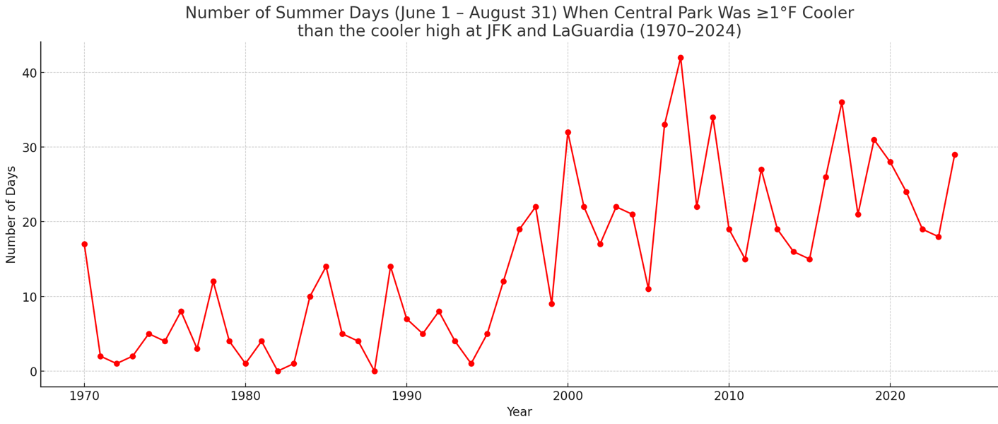
This was the reason that the NWS didn’t like to substitute readings at LGA back in the 1970s when the NWS equipment was out of service. Before the tree growth issue in the 1970s, LGA ran cooler than NYC did. So the NWS recognized that an open area of Central Park in the middle of Manhattan was a warmer part of NYC for summer high temperatures than right on the bay in Northern Queens. Central Park is our one ASOS in or around NYC which is the furthest distance from the water and local cooling breezes. So my estimate is that the placement of the ASOS under the trees has resulted in nearly 10 fewer 90° days reaching annually then they would be getting if the equipment was sited the same way prior to the 1990s. Annual 90° day counts for EWR, NYC and LGA during the 1961-1990 era prior to the ASOS being placed under the trees in the deep shade. EWR…..23 days NYC…..18 days LGA…..14 days Annual 90° day counts for EWR, NYC, and LGA during the most recent 15 year period of maximum tree growth and summer warming from 2010 to 2024. 12 out of the last 15 summers warmer to record warm across the region. EWR…..33 days for a 43% increase over 1961-1990 averages NYC…..19 days for only a 5% increase over 1961-1990 averages LGA…..25 days for a 78% increase over 1961-1990 averages The actual number of 90° days Central Park would be getting if the ASOS wasn’t under the trees would be around 28 a year. I arrived at this number by averaging the 43% increase at LGA and 78% at LGA. The average number was a 60% increase or 10 days more up to 28 days from 18 days. So the 5% increase from 1961-1990 should actually be 60%. So an annual undercount of 55% for 90° days if the ASOS was in a grassy clearing like the Great Lawn rather than beneath a densely wooded area of Central Park next to the castle. https://www.nytimes.com/1977/07/22/archives/vandals-in-central-park-forcing-weather-service-to-seek-new-site.html When the devices at the castle are not functioning, the Weather Service substitutes readings from La Guardia Airport. But Mr. Gibson said those readings do not really reflect conditions in the city, because they may be several degrees cooler in summer or warmer in winter than those in Central Park. -
Low of 57, amazing. Big Truck has their firework show tonight so we are partying today as we can see the fireworks from the backyard. Gonna be a great day for the pool. Pork is on the smoker and smells divine
-
Cooler temps this morning, but there is a bit of a smoky haze at the surface from last night. Air quality is poor.
-

July 2025 Discussion-OBS - seasonable summer variability
SACRUS replied to wdrag's topic in New York City Metro
Records: Highs: EWR: 103 (1999) NYC: 101 (1999) LGA: 100 (1999) JFK: 102 (1999) New Brnswck: 100 (1999) Lows: EWR: 54 (1979) NYC: 53 (1979) LGA: 56 (1979) JFK: 56 (1979) New Brnswck: 47 (1909) Historical: 1643: A violent windstorm hit the Plymouth Colony. The "sudden gust" downed trees and killed one Native American. This may have been the first documented American tornado or microburst. (Ref. Wilson Wx. History) 1816: In parts of New England and the Middle Atlantic, crop damage was severe and fruit trees were killed. In PA ice was found the thickness of window glass. In Savannah, Georgia the temperature dropped into the 40's on July 4th. (p. 33 Washington Weather Book 2002 by Ambrose, Henry, Weiss) 1882: A trace of snow was observed at Newton, NJ and other locations in the northeast. (Ref. Wilson Wx. History) 1891 - Sixteen horses were killed by hail, and many more have to be put to death due to injuries from a hailstorm at Rapid City, SD. (The Weather Channel) 1900 - A spectacular three day fire began when a bolt of lightning struck a refinery in Bayonne NJ. (David Ludlum) 1905: Washington Weather Bureau Office had 2.77 inches rain in one hour, 3.33 inches in two hours and 4.01 inches in 12 hours. The storm total was 4.64 inches in Baltimore, MD (Ref. Washington Weather Records - KDCA) 1916 - A hurricane produced 82 mph winds, an 11.6 foot tide, and a barometric pressure of 28.92 inches at Mobile, AL. (David Ludlum) 1936: South Dakota recorded its hottest temperature ever with a reading of 120° at Gannvalley. This same day Sioux Falls reached 109°, their second hottest temperature on record. Three of the 4 hottest days on record in Sioux Falls occurred during the Dust Bowl summer of 1936. (Ref. Lowest and Highest Temperatures for the 50 States) 1937 - The temperature at Medicine Lake, MT, soared to 117 degrees to establish a state record. (Sandra and TI Richard Sanders - 1987) 1937 - Midale and Yellow Grass in Saskatchewan hit 113 degrees to establish an all-time record high for Canada that same day. (The Weather Channel) 1967: Canadian high pressure continued to bring record lows to parts of the upper Midwest. Daily record lows included: Duluth, MN: 36°, Rochester, MN: 42°, Rockford, IL: 43°, Asheville, NC: 46°, Bristol, TN: 48°, Richmond, VA: 52°, Knoxville, TN: 54°, Wallops Island, VA: 56°, Charlotte, NC: 57 °F. (Ref. Wilson Wx. History) 1970: The morning low at Death Valley, CA was 103 degrees and the high that afternoon was 120 degrees. (The Weather Channel) 1972: Temperatures fell to record lows in the upper 30s and lower 40s across the Great Lakes region. The 37° at Lansing, MI was their coldest July reading of the 20th century. Other daily records included: Alpena, MI: 37°, Casper, WY: 38°, Sioux Falls, SD: 39°, Ste. St. Marie, MI: 39°, Huron, SD: 40°, Madison, WI: 40°, North Platte, NE: 42°, Topeka, KS: 43 °F.(Ref. Additional Temperatures Listed On This Link) 1970 - The morning low at Death Valley CA was 103 degrees, and the high that afternoon was 120 degrees. (The Weather Channel) 1974: Connecticut--A line of thunderstorms moved southeastward across the state. Lightning caused two deaths, one at Brookfield in Fairfield County and one at Bloomfield in Harford County. New Jersey--A line of thunderstorms moved eastward across the state in the afternoon. One man in Trenton was killed by lightning. New York City--A thunderstorm passed northeastward across the south and central sections of the city. Lightning struck three girls in Central Park, killing one and injuring two. Wilmington, Del.--A mother was killed by lightning while standing on her porch. (Ref. Lightning-The Underrated Killer.pdf) 1980: The “More Trees Down” started in western Iowa and tracked eastward affecting several states along its past before dissipating in eastern Virginia. 1987 - Severe thunderstorms raked south central Kansas for the second morning in a row. Thunderstorm winds again gusted to 80 mph at Clearwater, and in the Wichita area reached 100 mph. Twenty-five persons were injured at a trailer park at El Dorado Lake. (The National Weather Summary) (Storm Data) 1988 - Afternoon and evening thunderstorms spawned eleven tornadoes in Montana and three in North Dakota. Baseball size hail was reported at Shonkin, MT, and wind gusts to 85 mph were reported south of Fordville, ND. Twenty cities in the north central U.S. reported record high temperatures for the date, including Fargo ND with a reading of 106 degrees. Muskegon, MI, equalled their July record with a high of 95 degrees. (The National Weather Summary) (Storm Data) 1989 - Moisture from what once was Tropical Storm Allison triggered thunderstorms over the Middle Atlantic Coast Region, which deluged Wilmington, DE, with a record 6.83 inches of rain in 24 hours, including 6.37 inches in just six hours. Up to ten inches of rain was reported at Claymont, northeast of Wilmington. July 1989 was thus the wettest month in seventy years for Wilmington, with a total of 12.63 inches of rain. Alamosa CO reported an all-time record high of 94 degrees, and Pierre, SD, hit 113 degrees. (The National Weather Summary) (Storm Data) 1994: Thunderstorms, mainly packing high winds, erupted over north central Nebraska into south central South Dakota. As the storms moved east, 60 to 70 mph winds were common across the tri-state area. In Iowa, 65 mph winds were clocked in Monona County wrecking havoc with power lines. In Crawford County, 80 mph winds broke windows out of houses and caused some barn damage southwest of Charter Oak. Winds of 75 mph also swept into Sioux County causing significant damage to buildings on a farmstead near Hawarden. (Ref. Wilson Wx. History) 1999: July 4th and 5th ........"The Boundary Waters-Canadian Derecho" States that were affected --- ....ND, MN, ON, QB, NH, VT, ME (Ref. For More Information) 2001: International Falls, MN set a record low with 34°. 2.20 inches of rain fell in just 15 minutes at Pine Mountain, CA in Kern County. (Ref. Wilson Wx. History) 2003: Rockford, Illinois: An early morning band of severe thunderstorms blows across Northern Illinois with peak winds reported at 104 mph. Over 80,000 people are without power for various durations after the storm. (Ref. WxDoctor) 2004: For the second day in a row a derecho, a line of thunderstorms that produces widespread damaging winds, tracked from southeast Kansas into central Missouri across the Lake of the Ozarks region. (Ref. Wilson Wx. History) 2008: A streak of 26 consecutive days of 90°+ heat beginning on June 13th ended on this date at Denver, CO, shattering the previous record of 18 consecutive days established in 1874 & 1901. (Ref. Wilson Wx. History) -
July 2025 Obs/Disco ... possible historic month for heat
dendrite replied to Typhoon Tip's topic in New England
Hoodie morning
-

July 2025 Obs/Disco ... possible historic month for heat
OceanStWx replied to Typhoon Tip's topic in New England
Congrats on the 49! -
The system looks much more organized this morning with the COC more easily found on first visible images this morning. Overnight convection mainly east of the center has continued and there are some new bursts just east of it as I speak. With shear decreasing and an improved look this morning I would expect steady strengthening until landfall. Probably a 50-55kt ceiling. NHC notes the possibility of center reformation under the bursting convection and the storm has consistently been moving east of track so I wouldn’t be surprised if areas further north than current watch area, maybe up to cape lookout, end up seeing some of the worst weather from this lopsided storm
-
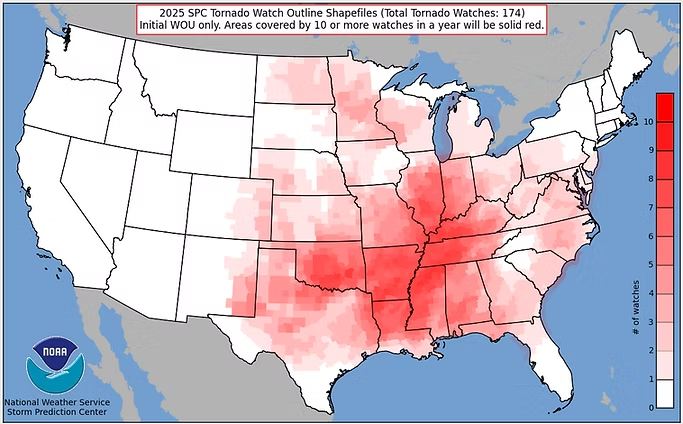
Zero tornado watches in eastern Iowa this year.
-
July 2025 Obs/Disco ... possible historic month for heat
dendrite replied to Typhoon Tip's topic in New England
And they did. -
Supposed to go to the Jersey Shore this coming week. Yesterday morning, forecasts had chance of rain under 5% for early in the week. "What could mess that up, so close to next week?", thought I. Wake up this morning to see the chance of rain is now over 70% each day. Of course! There's a ^$!#@&* tropical depression that's threatening to wreck my plans. Credible! Believeable!
-
July 2025 Obs/Disco ... possible historic month for heat
dendrite replied to Typhoon Tip's topic in New England
It blows my mind that CON had 15 July mins in the 40s in 1965. Then they finished August that year with a 29°. We have trouble even getting 1 morning in the 40s now. Looks like if you add all of the July 40s going back from present to 2011 you get 15. Greta bringin the dews now. Guess we’ll see in a min if CON snuck in a 49°. -
July 2025 Discussion-OBS - seasonable summer variability
SACRUS replied to wdrag's topic in New York City Metro
66 /64 off a low of 59. Another amazing beach day mid 80s to low 90s in the hot spots. Hotter tomorrow and monday with upper 80s low to mid 90s in the hot spots., although clouds from the tropical storm Chantal along the southeast could get in the way on monday. Watch any tropical impacts monday evening - tuesday otherwise Warm - hot / humid overall as the area is caught under the ridge with somewhat extra variable forecast pattern through mid month which should yield wetter - frequent storms and persistent onshore component. Hotter in the long range as ridge pushes heights and stronger heat expands north and east. - Today
-
July 2025 Discussion-OBS - seasonable summer variability
donsutherland1 replied to wdrag's topic in New York City Metro
Another look at Central Park's summer temperature issue: During 1970-1995, there were 5.4 days per summer when Central Park's high temperature was 1° or more cooler than the cooler high at JFK Airport and LaGuardia Airport. During 1996-2024, that figure was 22.8 days. Since 2000, that figure has averaged 24.0 days. The change in those averages are even more dramatic for days when Central Park had a high temperature that was at least 2° cooler than the cooler high at JFK Airport or LaGuardia Airport: 1970-1995: 1.3 days per summer 1996-2024: 11.1 days per summer 2000-2024: 12.2 days per summer Not all of this change has to do with the trees, but most of it does. One has seen smaller changes in the same direction for January 1-March 31 (no foliage) and October 1-December 31 (low foliage). However, the summer (full foliage) change is biggest. Change in Days with Highs 1° or More Cooler than the Cooler High at JFK Airport and LaGuardia Airport: 1996-2024 vs. 1970-1995: January-March: +93%; June-August: +322%; October-December: +122% Change in Days with Highs 2° or More Cooler than the Cooler High at JFK Airport and LaGuardia Airport: 1996-2024 vs. 1970-1995: January-March: +59%; June-August: +754%; October-December: +135%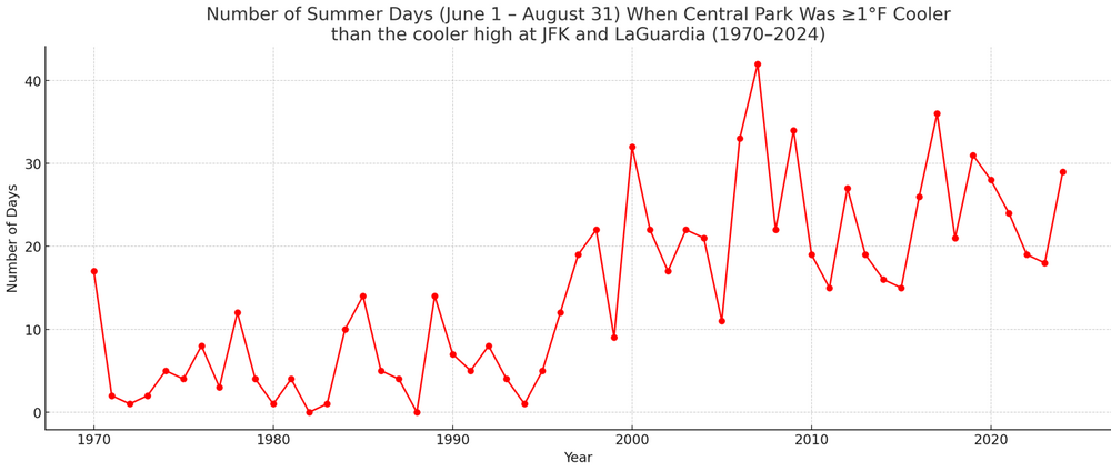
-
0z euro joined GGEM in bringing rain to the area Monday from TD3/Chantal. Euro gets rain to the 95 corridor while GGEM gets it back to the Blue Ridge.
-
Looks like it rebounded to a daily high of 93. Probably just a result of variable cloud cover.
-

July 2025 Discussion-OBS - seasonable summer variability
ForestHillWx replied to wdrag's topic in New York City Metro
Back to back morning lows of 57/58; very refreshing from the humidity of late. -

July 2025 Obs/Disco ... possible historic month for heat
Damage In Tolland replied to Typhoon Tip's topic in New England
Thankfully stayed in the 60’s at home . Avoided any terrible summer cool even if not there. -
July 2025 Obs/Disco ... possible historic month for heat
OceanStWx replied to Typhoon Tip's topic in New England
July morning of yore. -

July 2025 Discussion-OBS - seasonable summer variability
steve392 replied to wdrag's topic in New York City Metro
WOW, what an incredible morning coming to work. 60 degree's in Mahwah currently. -
Great temps this morning, but there is still visible smoke in the air from the festivities last night. Air quality is bad.