All Activity
- Past hour
-
yeah, seems like a rt 2 north day ...
-
Interesting seeing BOS be 90 with ESE 10kt harbor farts
-
Yes. That massive trough the Euro is toying with will kick this if that materializes (and it’s unclear if it will to that extent)
-
91.3° CON 96° so far
-
 Warmer than areas to the east like Long Island which get regular cooling sea breezes. A few NJ COOP sites have been warmer recently. Harrison has been pretty close. NJ just happens to be a very warm area away from the sea breeze. Data for June 21, 2025 through July 31, 2025 Average Maximum Temperarure Click column heading to sort ascending, click again to sort descending. SEABROOK FARMS COOP 92.8 INDIAN MILLS 2 W COOP 92.6 NEWARK LIBERTY INTL AP WBAN 91.5 Newark Area ThreadEx 91.5 HARRISON COOP 91.0 TETERBORO AIRPORT WBAN 90.7 OCEAN COUNTY AIRPORT WBAN 90.6 TETERBORO AIRPORT COOP 90.5 HIGHTSTOWN 2 W COOP 90.2 BELVIDERE BRIDGE COOP 90.0 Belvidere Area ThreadEx 90.0 map Data for June 21, 2025 through July 31, 2025 Maximum Temperature Click column heading to sort ascending, click again to sort descending. NEWARK LIBERTY INTL AP WBAN 103 HARRISON COOP 103 Newark Area ThreadEx 103 OCEAN COUNTY AIRPORT WBAN 103 ATLANTIC CITY INTL AP WBAN 102 INDIAN MILLS 2 W COOP 102 Atlantic City Area ThreadEx 102 MILLVILLE MUNICIPAL AIRPORT WBAN 101 LONG BRANCH-OAKHURST COOP 101 CANOE BROOK COOP 101 TETERBORO AIRPORT WBAN 101 CALDWELL ESSEX COUNTY AP WBAN 101 ESTELL MANOR COOP 101 TETERBORO AIRPORT COOP 101 SEABROOK FARMS COOP 100 HIGHTSTOWN 2 W COOP 100 NEW BRUNSWICK 3 SE COOP 100 SOUTH JERSEY REGIONAL AIRPORT WBAN 100 SOMERSET AIRPORT WBAN 100 PHILADELPHIA/MT. HOLLY WFO COOP 100 SALEM COOP 100 EB FORSYTHE NEW JERSEY RAWS 100 PENNSAUKEN 1N COOP 100
 -
Agreed. We came back from Maine in the middle of last week and were like... uh are we still in Maine?
-
Looks like MOS/machine was modestly cool biased ... ? Getting a lot of 94+ now. I also noticed the breeze kicked in here over the last hour. We were bouncing around 91 or 92, and then wind arrived and we observed a mini T jump in there. I mentioned this earlier... the models trying their best to limit the BL expansion heights, which of course would not realize the higher potential if that happened. I'm wondering if the over-turning took place.
-
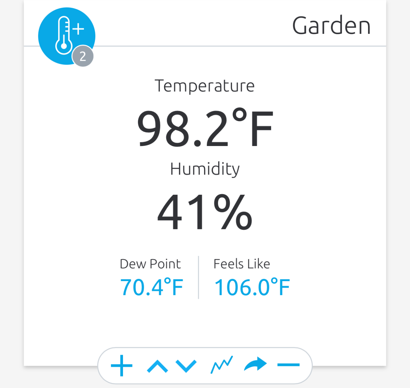
Even though I’m not, My garden is happy.

-
I think a big part of that is tied into that trough digging into southeast Canada. Seems to really do a number on that riding. If the GFS is too aggressive with that degree of troughing that could open the door for a stronger ridge
-
I think a direct U.S. impact is increasingly unlikely, but not fully closed. Worth a closer in Bermuda and Atlantic Canada imo.
-
I still think the GFS and its ensembles are too fast with the Atlantic ridge weakness, but we’d need substantial changes at medium range just to be a long shot in the ballgame for a close EC approach (saying nothing of the maritimes).
-
95 here
-
69 is not picnic at that temp, either. The HI is 100
-
 89.4 in Muttontown & 89.0 in Syosset for the high.
 -
 Peaked at 91/64 but now at 89 degrees
 -

-
Just a monster. I mean look at this. 12z And 00z Life support is probably putting it kindly though watch out Atlantic Canada..
-
It’s really not even hot out today. Feels like a standard midsummer day and it’s kind of great.
-
You beat MJO to it, but I think even he is skeptical. I’m thinking of buying a snowmobile again. If that happens we’re fucked. You can set your watch to that.
- Today
-
You may be referring to Western Queens, my area is not anymore populated than your area.
-
 Watch your language! Disgusting!
 -
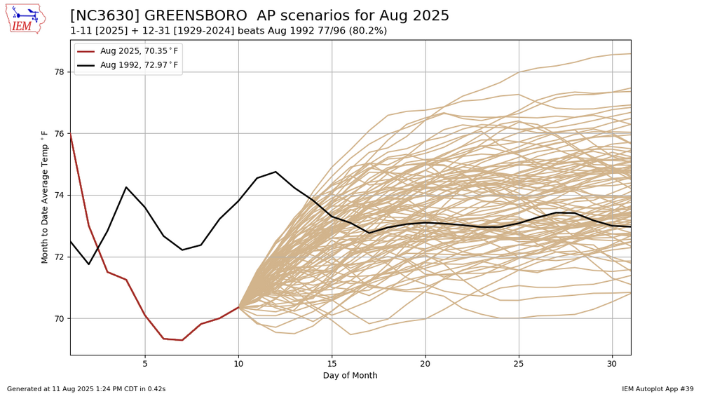
We have a legit shot at the coolest August on record