All Activity
- Past hour
-

October Comes Early: Late September Multi-Hazard Hybrid Storm
ineedsnow replied to WxWatcher007's topic in New England
oh please if you were at school still you would be doing the same thing -
 Pants off at home?
 -

October Comes Early: Late September Multi-Hazard Hybrid Storm
kdxken replied to WxWatcher007's topic in New England
-

October Comes Early: Late September Multi-Hazard Hybrid Storm
CoastalWx replied to WxWatcher007's topic in New England
Phones off at school -
Thank you! Totally agree!
-
October Comes Early: Late September Multi-Hazard Hybrid Storm
ineedsnow replied to WxWatcher007's topic in New England
perfect track and strength for a damaging SNE storm.. hopefully we can ramp this up even more -
Yes and Liam Likes !
-
October Comes Early: Late September Multi-Hazard Hybrid Storm
ineedsnow replied to WxWatcher007's topic in New England
@Damage In Tolland will like this run.thumb.png.92ae4e0ae6c24256a866d86b0d69e281.png)
-
September 22 1996: A brief cold air funnel touchdown results in roof damage in Washington County. 1936: Summer-like heat continues with 101 at Ada, Beardsley and Moorhead. For Tuesday, September 22, 2026 1890 - A severe hailstorm struck Strawberry, AZ. Fives days after the storm hail still lay in drifts 12 to 18 inches deep. (The Weather Channel) 1913 - Des Moines, IA, experienced their earliest freeze of record. (The Weather Channel) 1961 - Hurricane Esther made a near complete circle south of Cape Cod. The hurricane then passed over Cape Cod and hit Maine. Its energy was largely spent over the North Atlantic Ocean, however, heavy rains over Maine resulted in widespread local flooding of cellars, low roads, and underpasses. (David Ludlum) 1983 - Forty-one cities reported record cold temperatures during the morning. Houston, TX, hit 50 degrees, and Williston ND plunged to 19 degrees. (The Weather Channel) 1987 - Hurricane Emily, the first hurricane to roam the Carribean in nearly six years, made landfall over the Dominican Republic late in the day, packing 125 mph winds. Emily killed three persons and caused thirty million dollars damage. A record high of 92 degrees at Miami FL was their fifth in a row. (Storm Data) (The National Weather Summary) 1988 - An early morning thunderstorm produced baseball size hail at Plainview, in Hale County TX. Late in the evening more thunderstorms in the Southern High Plains Region produced wind gusts to 75 mph at Plainview TX and Crosby TX. (Storm Data) (The National Weather Summary) 1989 - Hurricane Hugo quickly lost strength over South Carolina, but still was a tropical storm as it crossed into North Carolina, just west of Charlotte, at about 7 AM. Winds around Charlotte reached 69 mph, with gusts to 99 mph. Eighty percent of the power was knocked out to Charlotte and Mecklenburg County. Property damage in North Carolina was 210 million dollars, and damage to crops was 97 million dollars. The strongest storm surge occurred along the southern coast shortly after midnight, reaching nine feet above sea level at ocean Isle and Sunset Beach. Hugo killed one person and injured fifteen others in North Carolina. Strong northwesterly winds ushered unseasonably cold air into the north central U.S., in time for the official start of autumn, at 8:20 PM (CDT). Squalls produced light snow in northern Wisconsin. Winds in Wisconsin gusted to 52 mph at Rhinelander. (Storm Data) (The National Weather Summary) 2005 - For the first time in the historical record, two hurricanes reached category-5 intensity in the Gulf of Mexico in a single season as Hurricane Rita intensified before making landfall (Katrina and Rita). 2006 - The tristate area of Missouri, Illinois, and Kentucky was struck by the worst tornado outbreak in the recorded history during the month of September. One supercell produced a long-track F4 tornado across southeastern Missouri into southwestern Illinois. This tornado traveled 27.5 miles. Observances: 22 Tue National White Chocolate Day 22 Tue Falls Prevention Awareness Day 22 Tue National Voter Registration Day 22 Tue American Business Women’s Day 22 Tue National Centenarian’s Day 22 Tue Car Free Day 22 Tue World CML (Chronic Myeloid Leukemia) Day 22 Tue World Car-Free Day 22 Tue Hobbit Day 22 Tue World Rose Day 22 Tue Autumnal Equinox (Start of Fall) 22 Tue National Elephant Appreciation Day 22 Tue Dear Diary Day 22 Tue National Girls’ Night In Day 22 Tue World Rhino Day 22 Tue Car-free Sunday 22 Tue Chainmail Day 22 Tue Elephant Appreciation Day 22 Tue International Day of Radiant Peace 22 Tue National Ice Cream Cone Day 22 Tue National Khalid Day 22 Tue National Legwear Day
-
October Comes Early: Late September Multi-Hazard Hybrid Storm
ineedsnow replied to WxWatcher007's topic in New England
.thumb.png.42a9db4b20ae37289958ade1de7d1351.png)
-

October Comes Early: Late September Multi-Hazard Hybrid Storm
Masswx replied to WxWatcher007's topic in New England
Icon gone wild at 114 -
October Comes Early: Late September Multi-Hazard Hybrid Storm
ineedsnow replied to WxWatcher007's topic in New England
ICON is a beast! that would do some damage -
October Comes Early: Late September Multi-Hazard Hybrid Storm
ineedsnow replied to WxWatcher007's topic in New England
going wild down to 981 mb at hr 102 -
Wholly unimpressive over here. 0.35" I guess overnight tonight is the best shot here, but quite a few models have nothing significant. Get this crap outta here and bring the nice Fall weather.
-

2026 Atlantic Hurricane Season
Windspeed replied to Stormchaserchuck1's topic in Tropical Headquarters
Has at times with respect to what? Declare something tropical or non-tropical to help insurance deductibles? Look, I am not going to get into the debate or semantics over if or if not something is classified by the NHC. Whatever their reasons back in 1991 for or against classification in a large hybrid system that gains an inner symmetrical tropical surface low. But I sure as hell will squash conspiracies with regards to the private sector or politics. -
Aporox 0.80” rain thru 9am Tuesday imby/Columbia.
-
Mid 20's-30's inland with low 40's along the shore. High's around 60 again. Broken record.
-
So we're (over)due then. Boom!
-

Septorcher 2026 Discussion - Endless Summer
jbenedet replied to Damage In Tolland's topic in New England
There’s actually three areas of SLP development and the one south of Cuba is the most interesting… -
Around .3 in Charlottesville. Pretty bad model miss on the overnight-afternoon period today as most CAMs showed rotating bands of showers/storms embedded in a steady rain shield. Only drizzle since the overnight period, but they show overnight tonight as the new rainy period.
-
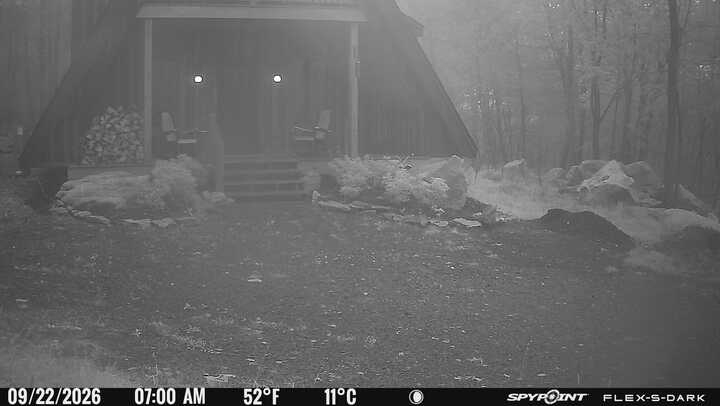
Wtf, did it snow up at DCL this morning? Temp on the game cam seems too warm but it certainly looks like snow on the ground.
-
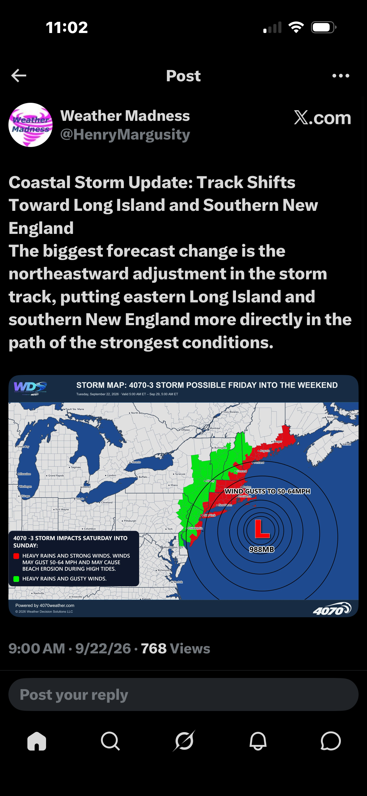
Margusiry gets it
-

2026 Atlantic Hurricane Season
vortex95 replied to Stormchaserchuck1's topic in Tropical Headquarters
Look at the loop here that shows the evolution before and after the time of the image you showed. https://rammb-data.cira.colostate.edu/tc_realtime/loop.asp?product=4kmirimg&storm_identifier=al062026&starting_image=2026al06_4kmirimg_202609201250.gif&ending_image=2026al06_4kmirimg_202609202220.gif That's not a real eye, just a residual dry slot that happen to look like one. You can see the continuous dry slot poke in towards the center before the feature forms, end then that feature goes away almost immediately. You have to be careful taking single images in such a case when TCs are developing and dry air is in proximity. -

E PA/NJ/DE Autumn 2026 Obs/Discussion
Birds~69 replied to PhiEaglesfan712's topic in Philadelphia Region
Happy first day of Fall! 59F/DP 57F (40s tonight)
-
1.04/1.66 day/event



.png.8e6a7ca36955023a4d4c22c7ee0bcc6e.png)

.png.a11674abd999cb152aea0348c5c8b1bb.png)