All Activity
- Past hour
-
Giving up on Monday/Tuesday huh?
-

Central PA Winter 25/26 Discussion and Obs
Jns2183 replied to MAG5035's topic in Upstate New York/Pennsylvania
It is showing returns but I look up to see blue sky Sent from my SM-S731U using Tapatalk -
Some models almost look like overrunning after any moderation. We hit the snooze button for a time after tonight. Then we’ll see how it looks after Monday or so.
-
I am really happy we were able to sneak in the big benchmark system in late January. But we have reverted back to the dominant storm track pattern since 2018-2019. With the blizzard getting suppressed to our south, we have returned to the cutter, hugger, and suppressed Southern Stream storm tracks.
-

Feb 10-11 Mid Week Minor Event - Ride the hot hand?
Kitz Craver replied to HoarfrostHubb's topic in New England
Strong bump game lately, I like it. -

Feb 10-11 Mid Week Minor Event - Ride the hot hand?
CoastalWx replied to HoarfrostHubb's topic in New England
He’s been going a little wild lately. Happens sometimes. -

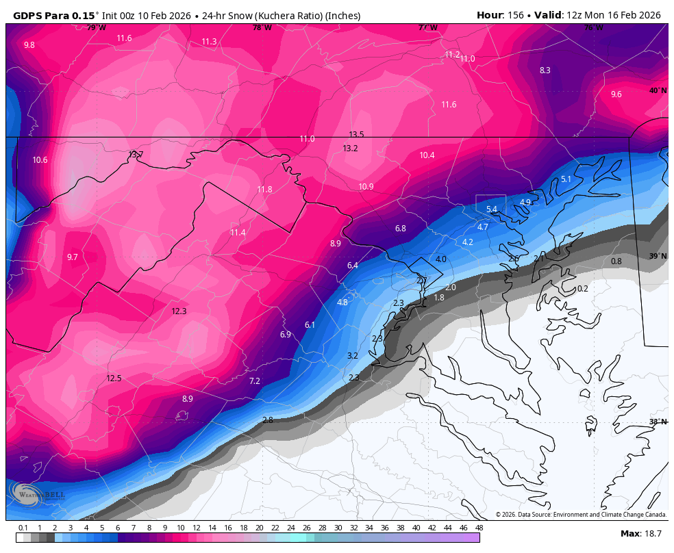
Feb 10-11 Mid Week Minor Event - Ride the hot hand?
40/70 Benchmark replied to HoarfrostHubb's topic in New England
I could see my area over to especially Amesbury breaking 3" up to maybe 4", but I think you have to go into NH for anything greater than 4". -

Is we back? February discussion thread
NorEastermass128 replied to mahk_webstah's topic in New England
Feb vacation starts with skis and ends with bikinis at the beach? Interesting… -
Feb 10-11 Mid Week Minor Event - Ride the hot hand?
40/70 Benchmark replied to HoarfrostHubb's topic in New England
You know me, so hope you didn't get your back up over those buns. I think you are a bit overzealous, but you know your stuff. I probably should have ticked 2-4" down into N Mass and may still update the map. -
 It's this models turn
 -

Feb 10-11 Mid Week Minor Event - Ride the hot hand?
dendrite replied to HoarfrostHubb's topic in New England
-

Feb 10-11 Mid Week Minor Event - Ride the hot hand?
Damage In Tolland replied to HoarfrostHubb's topic in New England
Euro was bad on that Wednesday event prior to the big one. Reggie nailed it and Nam was close. Mesos are having a good winter . We’ll see -

Central PA Winter 25/26 Discussion and Obs
Mount Joy Snowman replied to MAG5035's topic in Upstate New York/Pennsylvania
Sorry to hear that Voyager but man I am so far from being able to relate to this post. The thought of looking out my window in early February and being depressed because my yard is white is so foreign to me I don’t even know where to begin haha. But to each their own. Hang in there pal. -
GFS = Glue Factory System? But kidding aside I think we all know that’s a pipedream in Feb…although you can’t rule out a semi warm day in there.
-
Is we back? February discussion thread
Damage In Tolland replied to mahk_webstah's topic in New England
Well more than Aifs -
that was my last day above freezing as well, wonder how unusual it is for this much further south, got to be close to a record if not at least top 5... highest temp here in the last 30 days was 43.2 on 1/11... crazy impressive sustained cold. too bad it's been dry for most of it.
-
Is we back? February discussion thread
40/70 Benchmark replied to mahk_webstah's topic in New England
Winter is saved! -
 Please no
 -
Chance at some sleet/freezing rain later especially north of the city but maybe north shore as well.
-
 If it ain’t going to snow we might as well torch. I’m done freezing my ass off walking to class.
 -
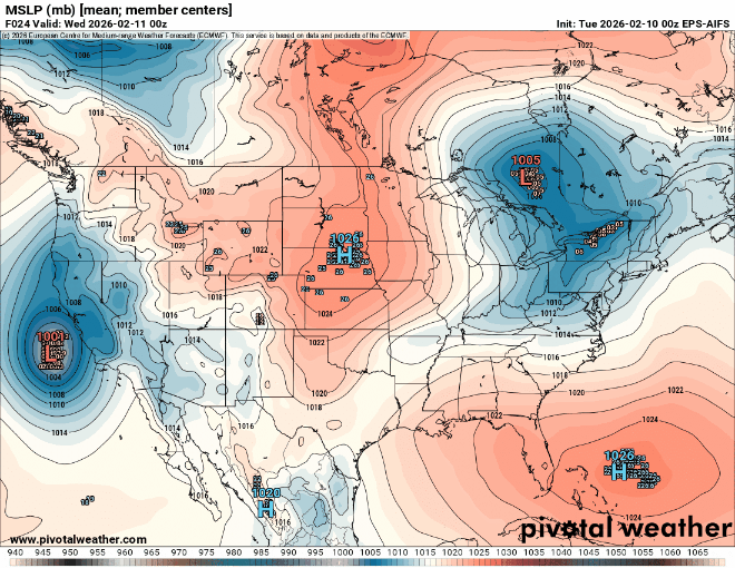
 Idk, all but a handful of Eps members has the slp in a decent location. In fact, just a few that are way ots skew the mean. We'll see.
.thumb.png.86cc898052e2fdf9008cd030ff93afd3.png)
-

February 2026 Medium/ Long Range Discussion: 150K Salary Needed to Post
bncho replied to Weather Will's topic in Mid Atlantic
Upgraded CMC is slightly warmer but it's an all snow event NW of I95
-

February 2026 Medium/ Long Range Discussion: 150K Salary Needed to Post
Heisy replied to Weather Will's topic in Mid Atlantic
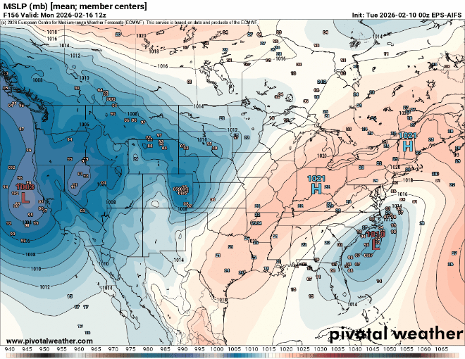
Technically this is an Archaumbault event with the NAO change. It argues for a stronger/farther N solution vs the Ai models. Euro Ai gives me the most pause for concern of course, but we’re still at range where we could maybe see some significant changes There’s also a world where the Ukie/cmc solutions are possible, similar 6z euro track but with the initial wave tracking farther N 00z Ukie was a MECS for interior to SNE 00z cmc parallel was like the Ukie but also got Philly in the game. Lots to parse. The pieces are there. We have 50/50, but the ULL helping reinforce the cold is a bowling ball and models are all over the place with it. Strong shortwave coming out of the pac, and finally x-factor to me is any northern stream piece that potentially tries to phase in last second. 6z eps comparison vs 00z, you can see that phase trying to happen with the energy over the lakes -
A few more frames would suggest the 6z ICON won’t miss south if extrapolated
-
Is we back? February discussion thread
40/70 Benchmark replied to mahk_webstah's topic in New England
@WinterWolfThoughts? How does this fit the overall tenor of the season? Do we know?


.png.fcc595c485b00420bc8a7d6c5cbf18cb.png)