All Activity
- Past hour
-
We have to look at recent trends more, September become a summer month now. Even October.
-
And maybe big storms. Sometimes we see derechos or big storm complexes on the periphery of these heat dome ridges.
-
This kind of reminds me of the evolution of the hot summer of 1980. From Tony's daily posts you can see that there were a bunch of cold low records from 1980 even at JFK from early to mid June. But the summer really began around June 20th as heat from the west expanded eastward. Although Saint Louis was the epicenter of the heat that summer, NYC had their hottest July-August couplet on record that year with those 62 days averaging over 80 degrees with August 1980 the hottest August on record here! The heat matched up with astronomical summer really well as it began on June 20th and ended September 20th. I remember a few of us brought up 1980 as an analog to this summer.
-
Sun’s out! Up to 59°
-
Yes that definitely looks like a NW flow event here, we could have the highest temperatures of the tristate area here!!
-
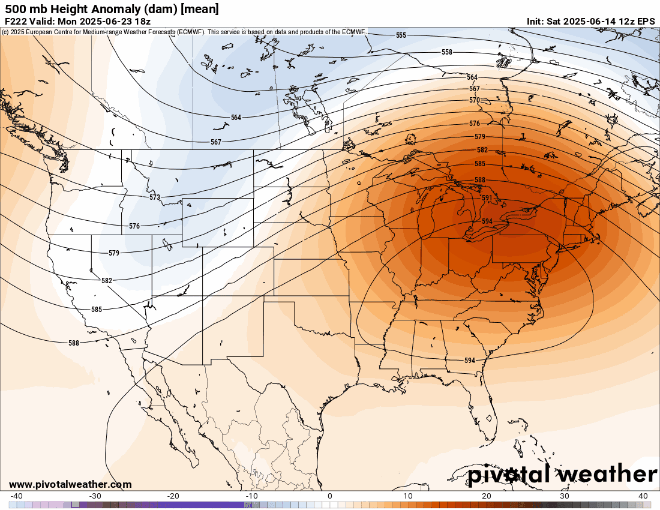
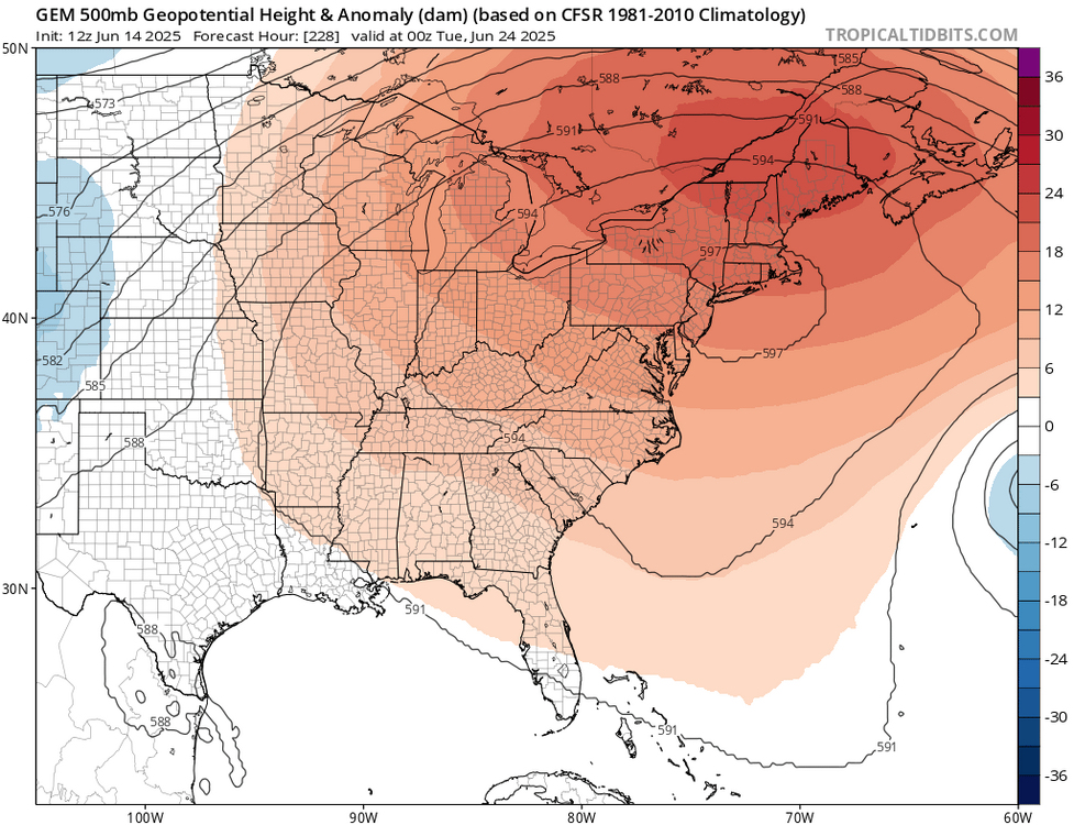
Hard to tell over a week out. But the EPS mean has westerly flow. So my guess is that most of the area away from the immediate shore will see their first mid to possibly upper 90s of the season. It’s a strong signal from an ensemble mean to see a 594 DM heat dome in the East over a week out.
-
That stuff in SW, VA is liking the environment we have in place. It's a tropical jungle out here in the lowland forest.
-
Terrible here at Colt State Park. Lots of parties ruined. Breezy, light drizzle/rain, 59 degrees. Although there may differing opinions on how much summertime ball sweat some of us enjoy, anything is better than this shit on a Saturday in June.
-
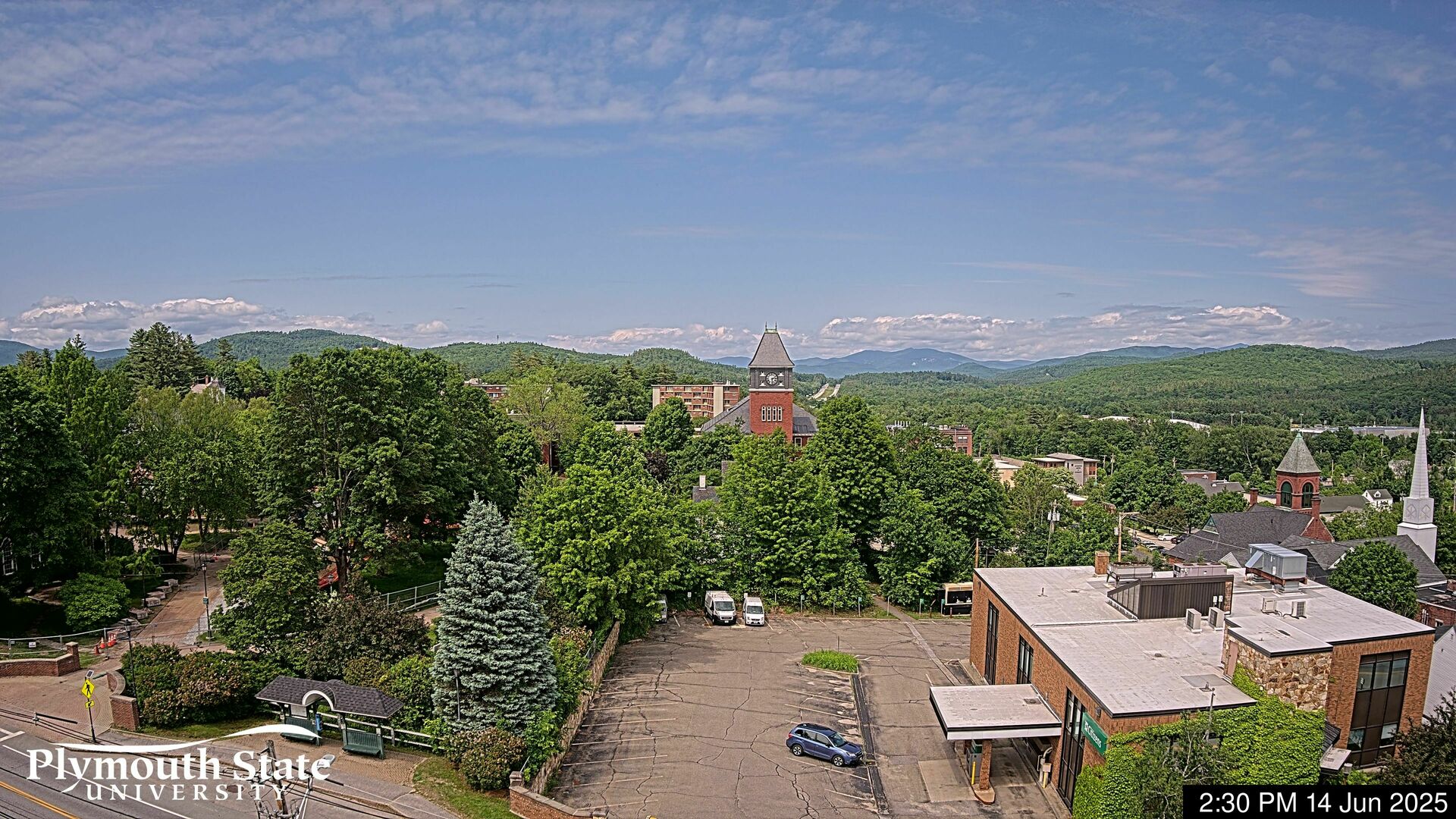
Cam from Plymouth right now looking north. Sky is def brightening here.

-
That one turned out to be more about DP the way I recall... I mean 94 was impressive enough, but we had DPs in the garden sites of Wunder like 82... is was sick. KFIT was 94/76 and that site is a notorious DP hole. I thought legit at the time, because the day it maxed ( 96/78 here) both my living room window AC unit, and my fucking refrigerator ( yes, the kitchen main appliance one...) died. As in throw away... right then and there. I remember scrambling to set up ice chests to store stuff, while of course ... no place had any window units in stock because everyone and their buddy Jack made a run on them. I did find a mom n pop that had a window unit, and also similarly a frig - but the frig is actually too big for this kitchen of mine ( oh wel - ), and the window unit made so much sound it was like a aeronautical test at an emission controls complex... I have mini splits now. Bring it on. But yeah...that one turned out to more HI than actual temperature.
-
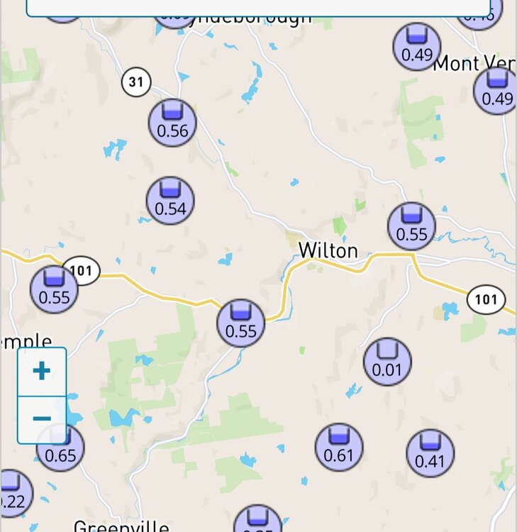
Looks like .5 - .6 will just about do it.
-
A severe storm with 45 mph winds 6:00 - 6:45 Friday evening. White out conditions with 2.75" rain in 45 minutes. Many trees down, my power was out 18.5 hours.
-
I remember this too. I was 11 years old at sleep away camp in Great Barrington, MA. Roaring winds came through in the morning, was a crazy storm. I believe it was visiting day and my parents had stayed in Stockbridge and apparently the Stockbridge bowl had white caps
-
Hoping I get another chance for significant rainfall today with the expanded flood watch
-
We roast
-
I remember that ... We had a shot at getting clipped by the ongoing historic heat over the Lakes region that day, but that derecho came thru at dawn and processed the heat south. We were forecast to 101 that day, but "only" made 92s in the wake of that beast - I think was Saturday. It was actually weakening quite a bit by the time it was passing through eastern Mass around 7 am or so... We still managed some 55 mph gusts, but nothing like what happened up the Mohawk Trail/Eastern NY/VT... I do recall seeing a rope funnel along dangling down from the outflow wedge tho - that was neat. The evening before, I remember a bank thermometer - back when they used to have those... - with an 89 in down town Maynard Ma, just before it click back to the time, 11:10 pm. I was blown away by that kind of heat that late at night. Seems like I've seen that in urban centers since though. For what it is worth, the 00z Euro some sort of an MCS like you're describing around 180 hrs from now.
-
In Parkville right now and it's hazy here too. Where's it coming from? (Not still Canada is it?)
-
 Table of forecasts for Seasonal Max 2025 FORECASTER ___________ DCA _NYC _BOS __ ORD _ATL _IAH __ DEN _PHX _SEA Scotty Lightning ________ 103 _ 100 __ 98 ____ 101 _ 103 _ 106 ___ 100 _ 121 __ 92 Roger Smith _____________ 102 _ 100 _ 100 ___ 101 _ 102 _ 107 ____107 _ 120 __ 99 Tom _____________________ 101 __ 99 __ 98 ___ 102 _ 103 _ 105 ___ 101 _ 118 __ 96 hudsonvalley21 _________ 101 __ 98 __ 97 ____ 100 _ 101 _ 101 ____ 100 _ 123 __ 97 so_whats_happening ____ 101 __ 97 __ 97 ____ 100 __ 99 _ 105 ___104 _ 118 __ 93 ___ Consensus __________101 __ 98 __ 98 ____ 100 _ 101 _ 105 ___ 102 _ 119 __ 95 wxdude64 ______________ 100 __ 99 __ 98 _____99 _ 101 _ 106 ___ 104 _ 118 __ 96 DonSutherland1 _________ 100 __ 98 __ 97 ____ 98 __ 98 _ 104 ___ 102 _ 117 __ 95 RJay _____________________100 __ 97 __ 99 _____ 98 _ 100 _ 105 ___ 102 _ 119 __ 95 wxallannj _________________98 __ 96 __ 95 _____ 95 __ 98 _ 101 ___ 104 _ 119 __ 93
 -
Your area has been getting the action lately. Let's keep the big heat out in the lakes region. Let's get those lakes nice and warm.
-
Verification time

-
Still 59 and 0.51”, rain continues
-
now that is some high end heat for our region on the Euro .. kind of reminds me of 2021 IIRC?
-
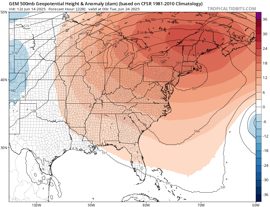
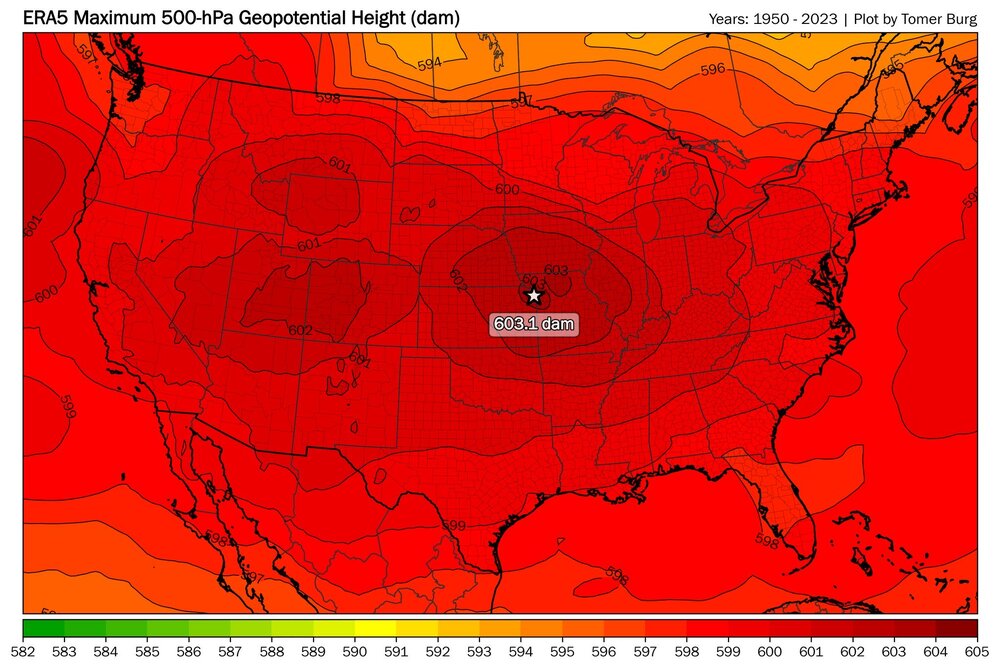
the ggem gets close to height records
-
Give him the heater, Ricky!

-
Movement