All Activity
- Past hour
-
Surfs up is the only thing that matters
-
Nice Eric
-
One of the reasons I like the SW Atlantic as a hot spot is the thermal environment. Erin is likely a blip, especially with it being mid August.
-
 I think we are underway with a significant dry pattern, much like last year. We'll see how long it persists but sure looks like the rest of this month is going to be dry. Expect upgrades (D1 or even D2) to the Drought Monitor in the coming weeks. Not expecting much today in terms of widespread coverage. If you get something consider yourself lucky.
 -
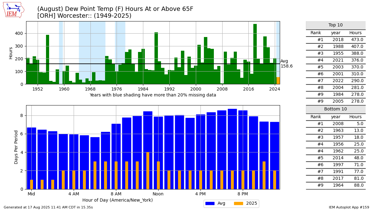
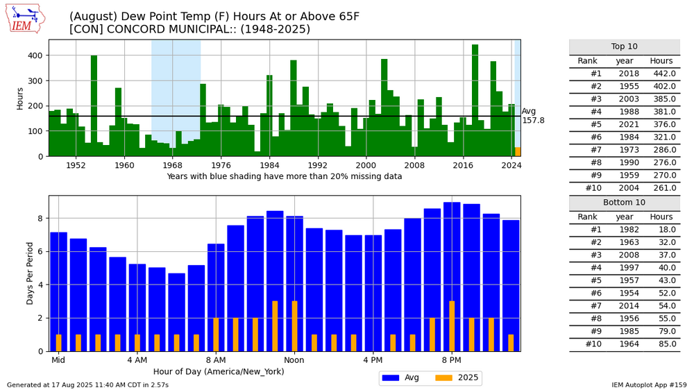
August dews have been way down.
-
 I think we get hit later. It is brutal out. Conditions ripe
 -
Oh heck yeah! Was not expecting this today (was thinking they would wait until September! This is the Orioles saying the equivalent of "HERE! Dang " to everyone screaming for him and Beavers, lol
-
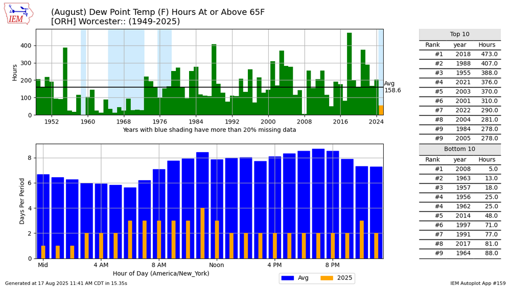
I didn't know that. I haven't flown into ORH lately.
-
Radiation. They’re on a hill top
-
Are you referring to the cool stretch, or the dry ground? ORH has amassed a drenching .35" in August.
-
It's whatever Joe Bastardi says it is! @snowman19
-
Ill take last year with more snow
-
Water will be churned up pretty good though?
-

NEW DISTURBANCE: Central Tropical Atlantic (0/20)
GaWx replied to BarryStantonGBP's topic in Tropical Headquarters
12Z UKMET: recurve with it moving NNW at end and aiming toward area around Bermuda: NEW TROPICAL CYCLONE FORECAST TO DEVELOP AFTER 96 HOURS FORECAST POSITION AT T+ 96 : 15.7N 54.7W LEAD CENTRAL MAXIMUM WIND VERIFYING TIME TIME POSITION PRESSURE (MB) SPEED (KNOTS) -------------- ---- -------- ------------- ------------- 1200UTC 21.08.2025 96 15.7N 54.7W 1009 28 0000UTC 22.08.2025 108 17.2N 57.2W 1007 28 1200UTC 22.08.2025 120 19.3N 60.2W 1006 30 0000UTC 23.08.2025 132 20.8N 61.9W 1006 32 1200UTC 23.08.2025 144 22.4N 63.8W 1005 35 0000UTC 24.08.2025 156 25.0N 64.5W 1005 41 1200UTC 24.08.2025 168 27.9N 65.8W 1005 43 -

NEW DISTURBANCE: Central Tropical Atlantic (0/20)
WxWatcher007 replied to BarryStantonGBP's topic in Tropical Headquarters
Given that look, with the ridge in SE Canada, I’m not so sure it hooks quickly, but we’re far out obviously at this stage. I’m on board though. I think the environment strongly supports eventual development. -

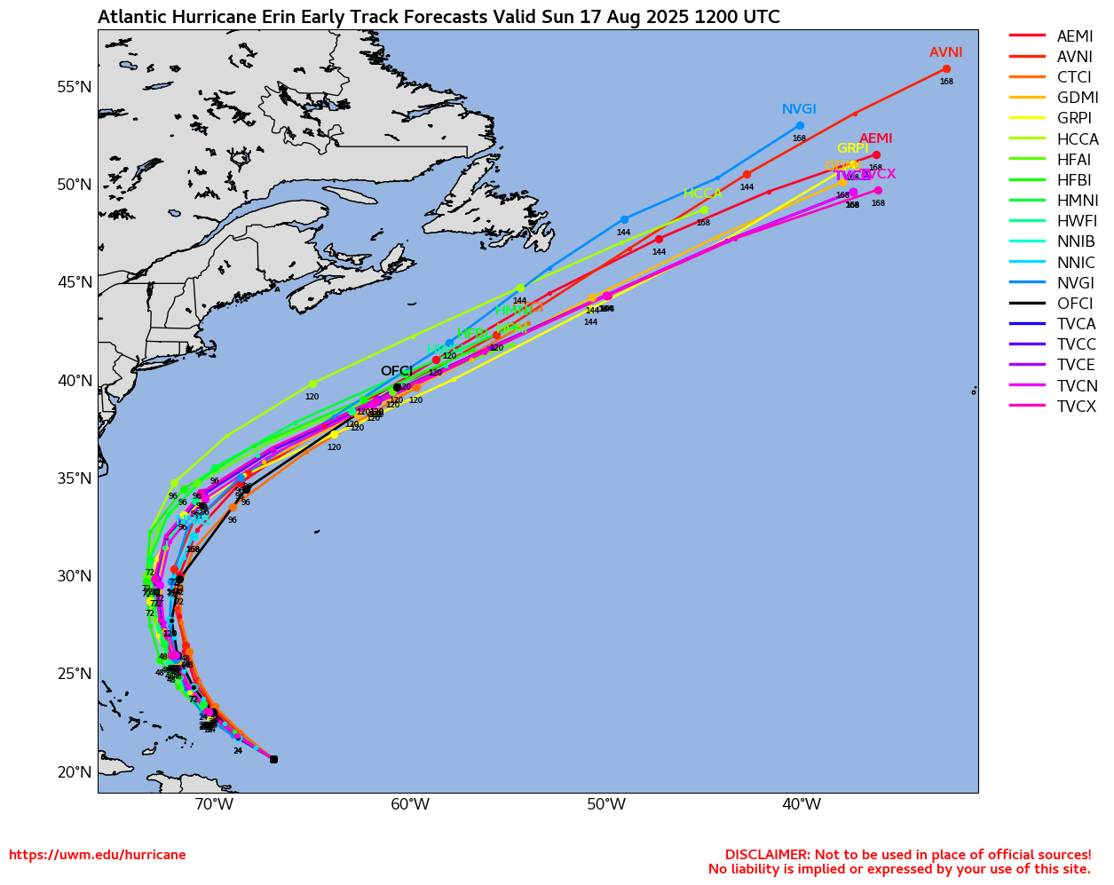
Hurricane Erin: 125 MPH - 946mb - WNW @ 13
Windspeed replied to BarryStantonGBP's topic in Tropical Headquarters
Though I do think Erin's core will complete organizing a new dominate and large eyewall at some point in the next few days, I think the RMW will have spread out too much for Erin to become a Category 5 again. When we have fast smooth transitions between EWRCs in the highest end TCs, the handoff of the windfield to new eyewall can allow the new eyewall to keep the RMW still somewhat compact or at least recontract it. Therefore, if the new eyewall remains with intense convection, the resultant pressure plunge can allow the TC to reapproach or even surpass its former peak. But the atmospheric and thermal environment has to remain prestinely favorable. We saw this with Irma through several EWRCs, Ian also comes to mind, among others, as Atlantic examples. Certainly, plenty of WPAC typhoons have reintensified dramatically after EWRCs. But in Erin's case, though it should get its act together and may reintensify some, it will likely run out of time to contract its RMW too much regardless of a dominate eyewall due to increasing shear on Monday through Wednesday. I could see it reaching Category 4 again, maybe, but I seriously doubt it could pull off Category 5 again. So, to answer your question, No Sir... -

Hurricane Erin: 125 MPH - 946mb - WNW @ 13
jconsor replied to BarryStantonGBP's topic in Tropical Headquarters
Erin continues to remain on the southern side of forecast spread today, but that may not matter much for possible impacts from NC to SE New England. Will Erin re-intensify now that her eyewall replacement cycle is done? Starting to make about half of my posts paid this week, so I encourage all of you tropical freaks to subscribe and support my work so you can see all of my hurricane-related posts. https://hurricanehacker.substack.com/p/systematic-bias -

Hurricane Erin: 125 MPH - 946mb - WNW @ 13
wthrmn654 replied to BarryStantonGBP's topic in Tropical Headquarters

-
Hurricane Erin: 125 MPH - 946mb - WNW @ 13
WxWatcher007 replied to BarryStantonGBP's topic in Tropical Headquarters
Haven’t had a chance to take a look yet, but I appreciate your stuff. -
NEW DISTURBANCE: Central Tropical Atlantic (0/20)
GaWx replied to BarryStantonGBP's topic in Tropical Headquarters
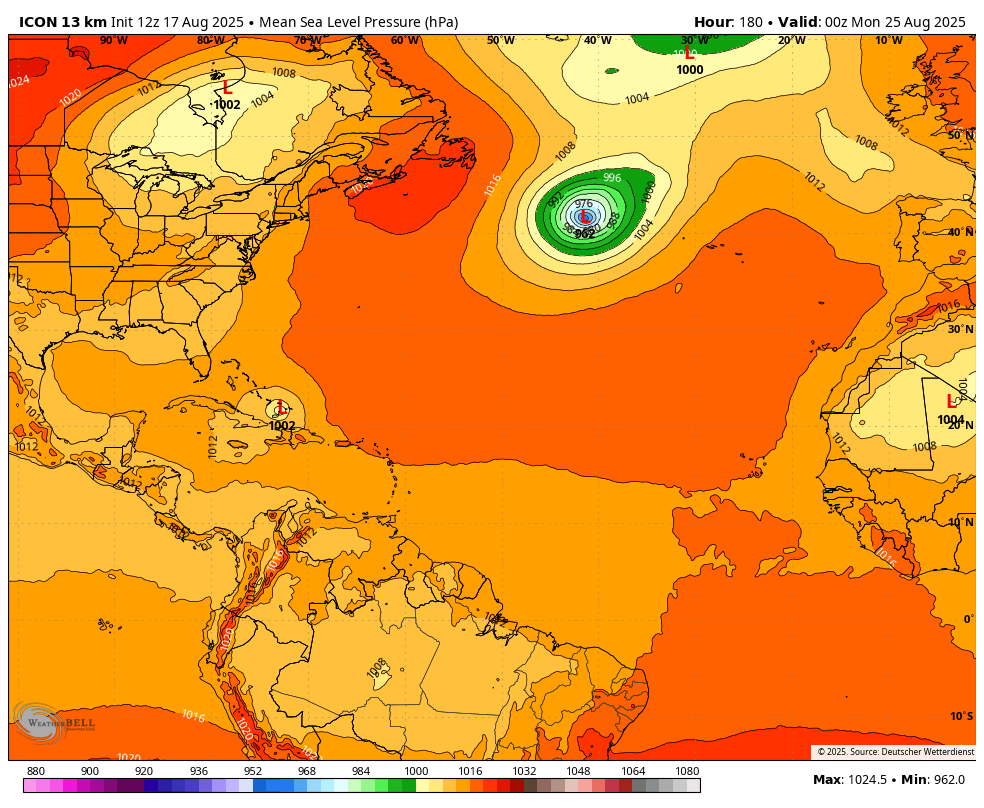
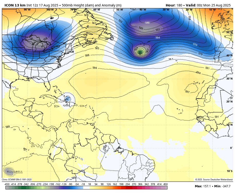
The 12Z Icon 180 position along with the run’s steering features including at H5 would appear to me to suggest a sharp recurve is about to commence fwiw. Sharp enough to avoid the E coast? Quite possible but impossible to know, especially for OB and Cape Cod. But details not important on 180 hour operational run, regardless.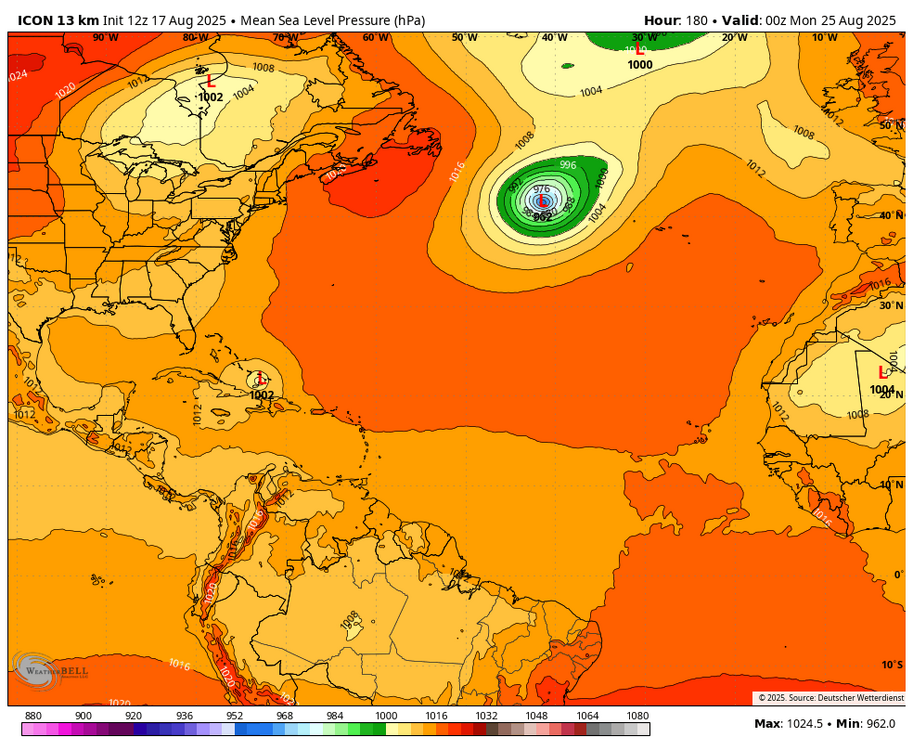
-
Hurricane Erin: 125 MPH - 946mb - WNW @ 13
wthrmn654 replied to BarryStantonGBP's topic in Tropical Headquarters
Looking thru the various sites i have, looking at the uAlbany site for the euro,gfs, cmc ensembles, the 06z forecast is only goes to, it's showing the 12z storm actual plot, the storm is south of all 3 of those models forecast... Here are 2 storm verification charts both are for location i do believe. - Today
-
 Current scoring for Seasonal Max contest 2025 TABLE of ERRORS to date _ _ _ _ errors in italics can only increase (forecasts lower than actual or equal) FORECASTER ___________DCA_NYC_BOS _ ORD_ATL_IAH _ DEN_PHX_SEA ___ TOTAL Scotty Lightning ________ 04 _ 01 _ 04 ____ 06 _ 03 _ 05 ___ 00 _ 03 _ 02 _____ 28 Roger Smith _____________03 _ 01 _ 02 ____ 06 _ 02 _ 06 ____07 _ 02 _ 05 _____ 34 Tom _____________________02 _ 00 _ 04 ____ 07 _ 03 _ 04 ___ 01 _ 00 _ 02 _____ 23 hudsonvalley21 __________02 _ 01 _ 05 ____ 05 _ 01 _ 00 ___ 00 _ 05 _ 03 _____ 22 so_whats_happening ____02 _ 02 _ 05 ____ 05 _ 01 _ 04 ___ 04 _ 00 _ 01 _____ 24 ___ Consensus __________02 _ 01 _ 04 ____05 _ 01 _ 04 ___ 02 _ 01 _ 01 _____ 21 wxdude64 _______________01 _ 00 _ 04 ____ 04 _ 01 _ 05 ___ 04 _ 00 _ 02 _____ 21 DonSutherland1 _________ 01 _ 01 _ 05 ____ 03 _ 02 _ 03 ___ 02 _ 01 _ 01 ______ 19 RJay _____________________01 _ 02 _ 03 ____ 03 _ 00 _ 04 ___ 02 _ 01 _ 01 _____ 17 wxallannj ________________ 01 _ 03 _ 07 ____ 00 _ 02 _ 00 ___ 04 _ 01 _ 01 _____ 19 ... will be adjusted whenever seasonal max change at locations ... ... BOS can no longer affect contest standings (all forecasts already passed) (forecasts) Table of forecasts for Seasonal Max 2025 FORECASTER ___________ DCA _NYC _BOS __ ORD _ATL _IAH __ DEN _PHX _SEA Scotty Lightning ________ 103 _ 100 __ 98 ____ 101 _ 103 _ 106 ___ 100 _ 121 __ 92 Roger Smith _____________ 102 _ 100 _ 100 ___ 101 _ 102 _ 107 ____107 _ 120 __ 99 Tom _____________________ 101 __ 99 __ 98 ___ 102 _ 103 _ 105 ___ 101 _ 118 __ 96 hudsonvalley21 _________ 101 __ 98 __ 97 ____ 100 _ 101 _ 101 ____ 100 _ 123 __ 97 so_whats_happening ____ 101 __ 97 __ 97 ____ 100 __ 99 _ 105 ___104 _ 118 __ 93 ___ Consensus __________101 __ 98 __ 98 ____ 100 _ 101 _ 105 ___ 102 _ 119 __ 95 wxdude64 ______________ 100 __ 99 __ 98 _____99 _ 101 _ 106 ___ 104 _ 118 __ 96 DonSutherland1 _________ 100 __ 98 __ 97 ____ 98 __ 98 _ 104 ___ 102 _ 117 __ 95 RJay _____________________100 __ 97 __ 99 _____ 98 _ 100 _ 105 ___ 102 _ 119 __ 95 wxallannj _________________98 __ 96 __ 95 _____ 95 __ 98 _ 101 ___ 104 _ 119 __ 93
 -
1. It’s a weak to very weak correlation at best regarding AN ACE to 35”+ NYC snow. Furthermore, correlation doesn’t necessarily mean causation. 2. If either of the two possibilities were to be the case even in a weak manner, I’d go with your 2nd option. 3. I’ve seen no indication about an even very weak correlation of recurving hurricanes and 35”+ NYC snow. 4. If anything, there may be a very weak correlation to seasons with 2+ US H hits and not the other way around. That sort of seems like the opposite 5. Regardless, how does one quantify the relationship of “recurving hurricanes” to 35”+ snowfall? That seems kind of vague/not very concrete.
-
 Yeah I don't think we see much tonight or for the next week
 -
 Definitely has climatology in its favor.