All Activity
- Past hour
-
How can the RGEM and GEMLAM be so different for Tuesday?
-
Yesterday the extended forecast was an unbroken string of 100's with zero rain. Long-range models always exaggerate about these things. Today the afternoon storm chances begin on Wednesday, and we go back to seasonal norms with daily storm risks. Only a mini-heatwave, I guess.
-
low of 67.8, up to 70.2 already... we climb
-
Ultima
-
 newej joined the community
 -
Do the people who are all gung ho for record heat and say they like it actually spend any appreciable time in it? Going from an air conditioned car to an air conditioned office to an air condirtioned home does not impress me. Granted I think @LibertyBell actually enjoys suffering in heat if he sleeps in temps over 80 voluntarily. I'm not so sure about some other people.
-
Took advantage of the gorgeous air and morning earlier with a nice 4 mile run. Get out there and do whatever you want!
-
Only got down to 71 this morning which is pretty rare for Tamaqua. We usually drop into the 60's no matter how high the daytime heat is.
-
Woof is it gross out.
-
7:15 and 81. Checked my station stats and looks like it never got lower than 80 overnight. The two Ms J’s have had tickets for a concert at Nats Stadium for a few months now. It is tonight and I am not going to lie I am concerned about them being out in these temps for it. They will be in the stands and covered but still has me worried.
-

2025-2026 ENSO
40/70 Benchmark replied to 40/70 Benchmark's topic in Weather Forecasting and Discussion
-
Min 64.5° Gonna be a rough 48hrs for mah chooks.
-
Overnight low of 69.4 here in Holyoke.. 72.3/71.7 now. Gonna be a scorcha! minisplits FTW.
-
Yesterdays high was 94 with a dewpoint of 80.6 and heat index of 114. Totally sultry! Low this morning was 68.
-
Newark is currently 85° at only 7am. The Euro has the correct temperature from its 0z forecast. It makes a run on 103° later. That would tie the all-time June record set back in 2021. The forecast for tomorrow is a few degrees warmer at 105°.
-
Gooooood morning! Beautiful day in Arlington MA!
-
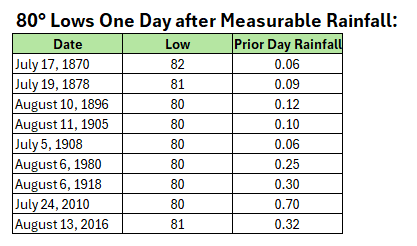
Today is on track to become New York City's 10th occurrence with a low temperature of 80° or above one day after measurable rainfall. It would be the first such occurrence in June. The list is below:
-
Nasty out there.
-
-
HRRR has mid 90s for the island before the sea breeze kicks in in the early afternoon. The NAM doesn't even have Islip hitting 90 today, that will horribly bust lol
- Today
-

2025 Atlantic Hurricane Season
BarryStantonGBP replied to BarryStantonGBP's topic in Tropical Headquarters
Looking like shit now 00z CMC has what appears to be a retrograding weak low off of the FL panhandle in about 8 days. -
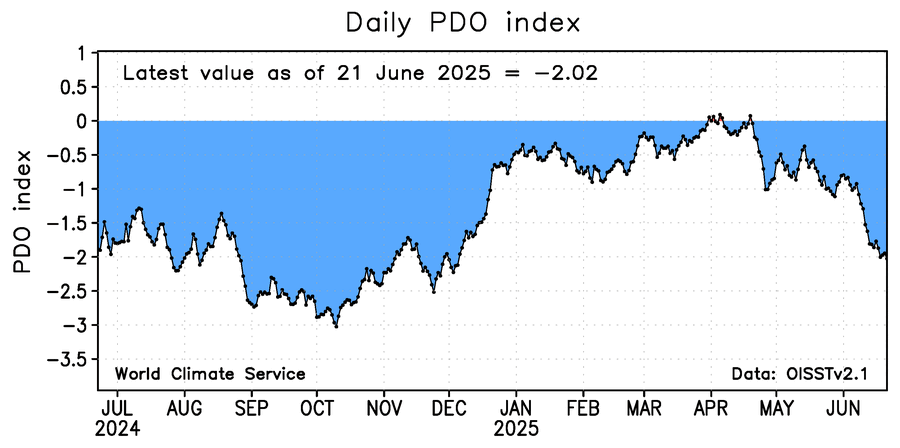
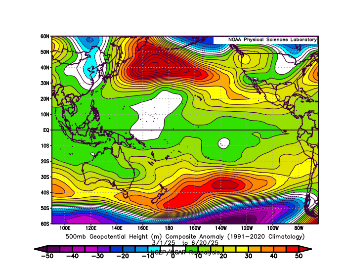
The record breaking Aleutian Ridge continues to warm the SSTs below leading to these persistent -PDOs again dropping back under -2.00. So the net effect is a record Southeast Ridge like we are seeing this week near 600 dm. This is what is driving such a strong La Niña background pattern. So there is probably a feedback process leading to the record warm subtropical SSTs. The RONI would be much lower if we subtracted the Nino 3.4 tropical SST departures from the subtropical.
-
Only managed a low of 65. The forecast was for 63. looks like a beaut in store today before tomorrow’s mild-up. Progged high today is 80.
-
RECORD EVENT REPORT NATIONAL WEATHER SERVICE NORTHERN INDIANA 205 AM EDT MON JUN 23 2025 ...RECORD WARM MINIMUM TEMPERATURE SET AT SOUTH BEND FOR JUNE 22ND... A RECORD WARM MINIMUM TEMPERATURE OF 77 WAS SET AT SOUTH BEND YESTERDAY. THIS BREAKS THE OLD RECORD OF 74 SET IN 2024 AND 1988.
-

June 2025 discussion-obs: Summerlike
LongBeachSurfFreak replied to wdrag's topic in New York City Metro
It’s all going to come down to wind direction for the coast today. EWR is a lock for 100 coming of a low of 82. -
Interesting. Could definitely be playing a role in the strong +NAO winter tendency we’ve been seeing for years now. Besides the +AMO, I also think arctic sea ice and climate change have a hand in it too


