All Activity
- Past hour
-
I say wait until it’s snowing in northern Mississippi next Friday first
-
Icon trending back our way ever so slightly. .
-

January 25-26 Winter Storm Potential
MickeyTim6533 replied to Ralph Wiggum's topic in Philadelphia Region
Hearing on the other forums, euro with a huge dry slot? thoughts? -
Almost every OP model has the same general look for the 31st-1st as our block retrogrades south. .
-
.thumb.jpg.6a4895b2a43f87359e4e7d04a6fa0d14.jpg)
Central PA Winter 25/26 Discussion and Obs
Yardstickgozinya replied to MAG5035's topic in Upstate New York/Pennsylvania
F*** yeah,! It's go time, men. She's coming to papa. -
1.6"
-
Measured 2". Nice little event.
-
For the following weekend?
-
Feb 2014 on steroids?
-

Possible Record Breaking Cold + Snow Sunday 1/25 - Tuesday 1/27
BoulderWX replied to TriPol's topic in New York City Metro
Warm nose apparent on the ICON at 06z - ugly depiction and a big step back from OOZ -
Central PA Winter 25/26 Discussion and Obs
Yardstickgozinya replied to MAG5035's topic in Upstate New York/Pennsylvania
Toggle navigation Watches, Warnings & Advisories 2 products issued by NWS for: Goldsboro PA Winter Storm Watch URGENT - WINTER WEATHER MESSAGE National Weather Service State College PA 206 AM EST Thu Jan 22 2026 PAZ026>028-034>037-041-042-046-049>053-056>059-063>066-222145- /O.NEW.KCTP.WS.A.0002.260125T0300Z-260126T1800Z/ Huntingdon-Mifflin-Juniata-Bedford-Fulton-Franklin-Tioga-Northern Lycoming-Sullivan-Southern Lycoming-Union-Snyder-Montour- Northumberland-Columbia-Perry-Dauphin-Schuylkill-Lebanon- Cumberland-Adams-York-Lancaster- Including the cities of Laporte, Mifflintown, Berwick, McConnellsburg, Lewistown, Mansfield, Mount Union, Huntingdon, Lebanon, Shamokin, Chambersburg, Pottsville, Hershey, Trout Run, York, Lewisburg, Lancaster, Harrisburg, Selinsgrove, Wellsboro, Carlisle, Bedford, Williamsport, Danville, Gettysburg, Newport, Bloomsburg, and Sunbury 206 AM EST Thu Jan 22 2026 ...WINTER STORM WATCH IN EFFECT FROM SATURDAY EVENING THROUGH MONDAY AFTERNOON... * WHAT...Heavy snow with significant accumulations possible. Snow may mix with or transition to sleet in southern PA on Sunday and Sunday night. * WHERE...A portion of central Pennsylvania. * WHEN...From Saturday evening through Monday afternoon. * IMPACTS...Roads, and especially bridges and overpasses, will likely become slick and hazardous. Travel could be difficult late Saturday night through Monday morning.+ PRECAUTIONARY/PREPAREDNESS ACTIONS... Monitor the latest forecasts for updates on this situation. Slow down and use caution while traveling. The latest road conditions for the state you are calling from can be obtained by calling 5 1 1 or visiting 511PA.com. && $$ For more information from the National Weather Service visit weather.gov/StateCollege Banghoff/Bauco Hazardous Weather Outlook Hazardous Weather Outlook National Weather Service State College PA 211 AM EST Thu Jan 22 2026 PAZ026>028-034>037-041-042-046-049>053-056>059-063>066-230715- Huntingdon-Mifflin-Juniata-Bedford-Fulton-Franklin-Tioga- Northern Lycoming-Sullivan-Southern Lycoming-Union-Snyder-Montour- Northumberland-Columbia-Perry-Dauphin-Schuylkill-Lebanon-Cumberland- Adams-York-Lancaster- 211 AM EST Thu Jan 22 2026 ...WINTER STORM WATCH IN EFFECT FROM SATURDAY EVENING THROUGH MONDAY AFTERNOON... This Hazardous Weather Outlook is for central Pennsylvania. .DAY ONE...Tonight. Brief rain or snow showers are possible overnight and could lead to reduced visibility. .DAYS TWO THROUGH SEVEN...Thursday through Tuesday. Please listen to NOAA Weather Radio or go to weather.gov/StateCollege on the internet for more information about the following hazards. Winter Storm Watch. An extended period of frigid weather is expected Friday into next week with sub-zero to potentially dangerous wind chills. Saturday morning and Tuesday morning will be the coldest. .SPOTTER INFORMATION STATEMENT... Spotters are encouraged to report significant hazardous weather. $$ US Dept of Commerce National Oceanic and Atmospheric Administration National Weather Service 1325 East West Highway Silver Spring, MD 20910 Comments? Questions? Please Contact Us. Disclaimer Information Quality Help Glossary Privacy Policy Freedom of Information Act (FOIA) About Us Career Opportunities View in Desktop Mode -
Was it going to transfer to the coast you think? Because the primary was pushing north… I wonder…
-
Nam was about to go wild at hr84
-
1 1/2"
-
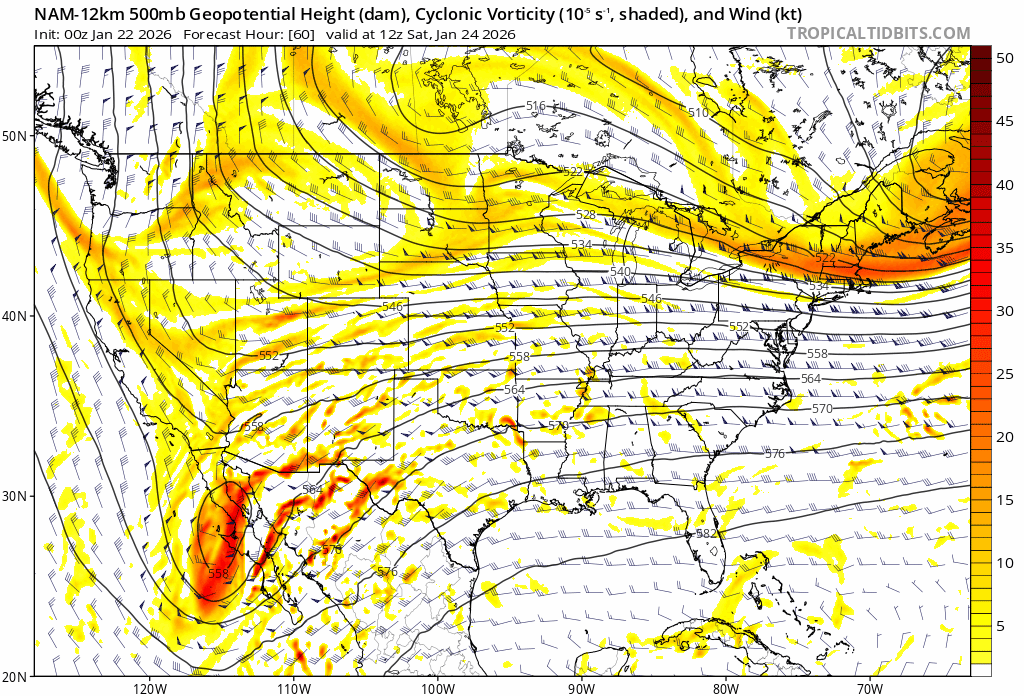
NAM is looking really amped by hr66
-
It is wild to me though how we swung from a legit concern about suppression to now mix making as far north as the LV with potential to make it even farther north lol. We still get thumped though
-

-
6z NAM looks like it will dig more this run.. should see some great solutions today..
- Today
-

January 25/26 Jimbo Back Surgery Storm
Coach McGuirk replied to Jimbo!'s topic in Southeastern States
A Winter Storm Watch for: "rain, snow, sleet, freezing rain, who the fuck knows." -
January 25/26 Jimbo Back Surgery Storm
Coach McGuirk replied to Jimbo!'s topic in Southeastern States
Like me, Wakefield has zero idea what is going to happen. Friday A slight chance of rain after 1pm. Partly sunny, with a high near 49. Calm wind becoming north around 6 mph in the morning. Chance of precipitation is 20%. Friday Night Mostly cloudy, with a low around 19. North wind 5 to 14 mph, with gusts as high as 22 mph. Saturday A chance of snow after 1pm. Mostly cloudy, with a high near 29. Chance of precipitation is 30%. Saturday Night Snow before 1am, then snow and sleet. The snow and sleet could be heavy at times. Low around 22. Chance of precipitation is 100%. Sunday Rain, snow, and sleet, becoming all rain after 7am. The sleet could be heavy at times. High near 38. Chance of precipitation is 100%. Sunday Night Rain, snow, and freezing rain, mainly before 1am. Low around 26. Chance of precipitation is 80%. Monday A chance of snow before 1pm. Mostly sunny, with a high near 35. Chance of precipitation is 30%. -
1/23/26-1/25/26 Winter Storm Thread
Save the itchy algae! replied to AMZ8990's topic in Tennessee Valley
Well my 24 hour self ban didn’t work. At this point may as well make the somewhat happy reminder at this point that even with colder surface temps freezing rain won’t accumulate if it’s coming down in moderate rates. So the euro might be picking up on this with its rain solution, even if it’s erroneous on the actual temp profile. I guess it depends on how much sleet there is for the rain to stick to at this point in the CV. This one hurts guys, but we need the rain.. -
Recon out flying.. models should get better today
-
Yeah the NFL got soft. They postponed the steelers at bills playoff game a few years ago due to heavy snow
-

Possible Record Breaking Cold + Snow Sunday 1/25 - Tuesday 1/27
Prue11 replied to TriPol's topic in New York City Metro
Atleast 1/3 of the United States is under a winter storm watch/warning -
1.5... best looks like it was south of here but ill take a nice refresher