All Activity
- Past hour
-

2025-2026 ENSO
40/70 Benchmark replied to 40/70 Benchmark's topic in Weather Forecasting and Discussion
2013-2014 also didn't have any higher end KU events if I am not mistaken....perhaps I am, not sure. But I know for my area, there were no really memorable events, which are tougher to achieve without a well placed PNA ridge. It's much easier to get more moderate snowfalls, which is mostly what we saw. -
2025-2026 ENSO
40/70 Benchmark replied to 40/70 Benchmark's topic in Weather Forecasting and Discussion
It's much easier to have east coast winter weather in general without an active PAC jet...I'm not arguing it's favorable. But it's not the only reason the east coast has been struggling. The pattern has sucked. We did manage a -WPO in 2021-2022. -
Much easier to get a strong -WPO with a relaxed Pacific Jet not constantly eroding the ridge.
-
2025-2026 ENSO
40/70 Benchmark replied to 40/70 Benchmark's topic in Weather Forecasting and Discussion
That was one of the most severe -WPO seasons on record. Like I said, nothing operates in a vacuum and there are no absolutes. Lets look at the following year....we must really want an extraordinarily +AO/NAO than. -

September 2025 OBS-Discussion centered NYC subforum
STORMANLI replied to wdrag's topic in New York City Metro
Not impossible to get a long-term drought, but not too likely given the convergence of storm tracks in our area. -
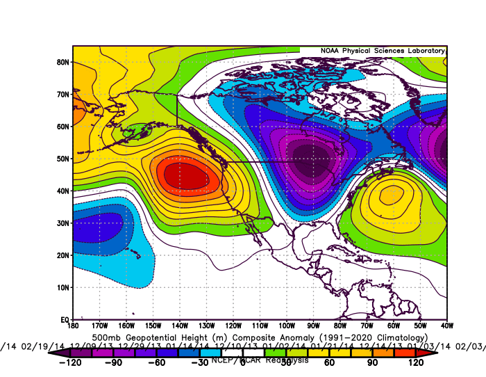
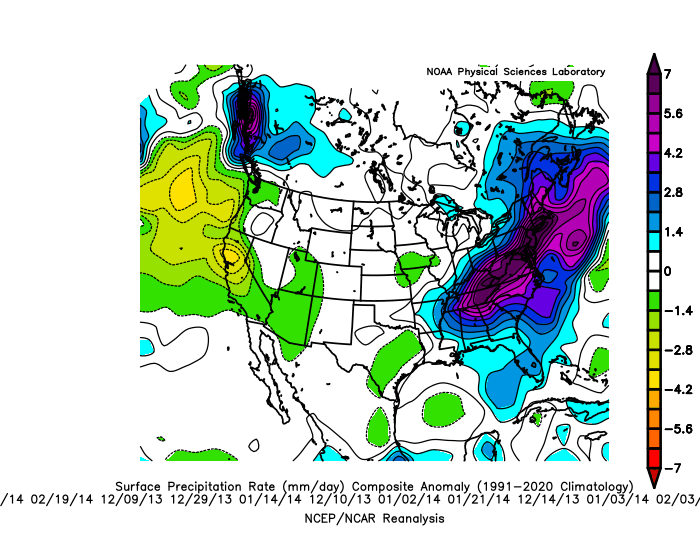
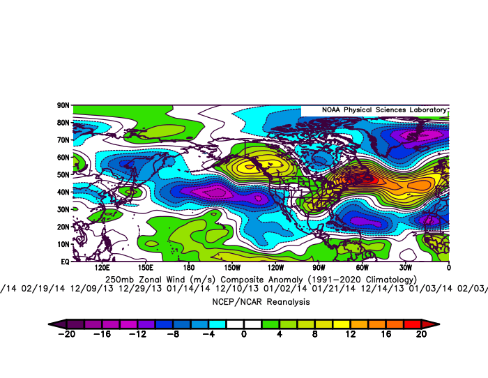
The ridge axis was centered just off the West Coast during the 13-14 winter on the wettest storm days for NYC leading to that much snowier outcome than last winter. But the Pacific Jet was significantly weaker. So it allowed the 500mb ridge to remain in place and not get weakened and undercut by such a fast Pacific Jet. The lack of kickers coming into the West Coast during 13-14 with the weakened Pacific Jet allowed the colder storm track just southeast of NYC with numerous BM redevelopers. The Southeast ridge was much weaker and further east than recent years. 18 storm days for NYC DJF 13-14 with .20+ of precipitation
-

September 2025 OBS-Discussion centered NYC subforum
jm1220 replied to wdrag's topic in New York City Metro
I’m not sure a true long term drought that would lead to widespread water restrictions like out west is possible with our changing climate. So many ways we can get drenched from a one off deluge or generally ways we can get rain. Our long term precip averages have been going up with our temps. -
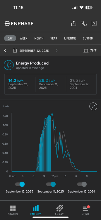
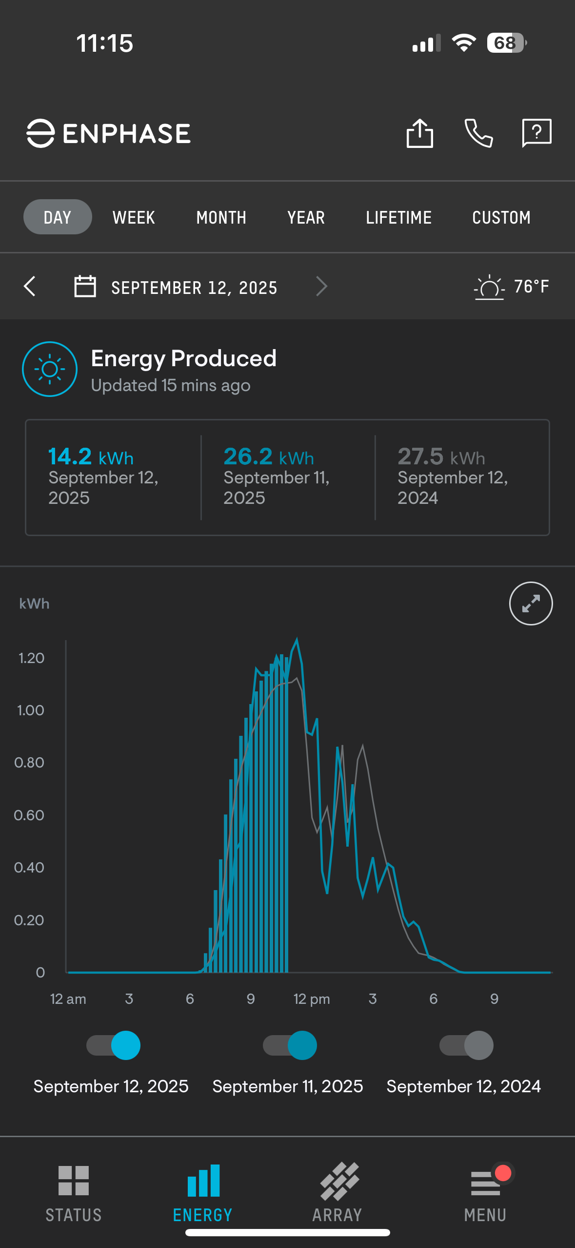
Looking to do more power today than yesterday. Threw in last year to compare. And this is with one Micro Inverter not reporting. New one is on its way.
-

2025 Atlantic Hurricane Season
Wannabehippie replied to BarryStantonGBP's topic in Tropical Headquarters
SAL has eased up, which will give a window for the new system coming off of Africa to develop in a few days. It is currently at 0% in next 48, but increases to 40% in next 7 days. Even with that, it looks like it will be a fish storm, if it develops. https://www.nhc.noaa.gov/gtwo.php?basin=atlc&basin=atlc&fdays=7 -
Yeah I drove up to the cabin for that storm and it was a nightmare on the roads. We had a solid foot from it though it melted pretty quick.
- Today
-
Altho they do fly strategically - they are impressively hard to stomp
-

2025 Lawns & Gardens Thread. Making Lawns Great Again
IrishRob17 replied to Damage In Tolland's topic in New England
I've wondered something similar about these random blades of grass that pop up in the driveway or walkway. No water, no fertilizer, no nothing but they mange to grow while other parts of the lawn itself are brown. -
2025-2026 ENSO
40/70 Benchmark replied to 40/70 Benchmark's topic in Weather Forecasting and Discussion
Yes. -

Occasional Thoughts on Climate Change
donsutherland1 replied to donsutherland1's topic in Climate Change
Even as a La Niña event is in its formative stages following a neutral-cool/borderline La Niña winter, 2025's global temperatures remain stubbornly warm. The September 1-10 period ranked as the third warmest (ERA-5 dataset). It was 0.10°C warmer than the fourth place 2020.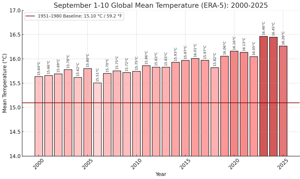
-
2025-2026 ENSO
40/70 Benchmark replied to 40/70 Benchmark's topic in Weather Forecasting and Discussion
If you view the dailies from the dates of major storms, the PNA ridge is centred just off of the west coast. I don't care how fast the PAC jet is, that wouldn't have worked out in 1852. I do agree that PAC jet has been an issue in general, as it makes it more difficult to time the palcement of the PNA ridge correctly, and for it not to fold too quickly. Here is a prime example from last winter of the Pacific jet undercutting a +PNA ridge and thus tilting it positively, leading to a failed phase attempt on the east coast. -
i mean we still probably will get a good period of HL blocking w/ -EPO and +PNA its just that theres going to be more SER (especially before/after good periods) with a more developed nina since -QBO relates to more active MJO
-
Yeah maybe although lanternflies don’t exactly fly gracefully to my eye lol
-
I have to assume the cicadas didn’t get high enough, being fat and clumsy. Not sure how high the lantern flies can go, but it seems to be high enough.
-
I have been discussing this for a while now. The rapid expansion of the mid-latitude ridging has been altering the way that the higher latitude teleconnections have been occurring relative to the past. We have also been seeing a much faster Pacific Jet with the record mid-latitude SSTs under these expanding ridges.
-
+QBO causes the tropical tropopause to stabilize which makes convection focus further off the equator which shifts the pattern more poleward, -QBO would have more active MJO(in general) but more focused on the equator
-
Closing in on a month of dry here, only 1/10" since 8/18. Everything started getting crunchy this week. Hail Mary conditional chance for a little training overnight/tomorrow morning, but if that doesn't manifest gonna get into the yellow on the drought map. Last several GFS runs showing a low breaking the ridge down next weekend but then has it coming back after, Euro isn't biting, ridge in place to the end. That early taste of fall might be all she wrote until October.
-
That was a pretty good storm out in the Garrett County area as well. I ended up with exactly a foot.
-
Foggy morning, with a batch of shwrs/stms moving across N MN. Might see something later.
-
How can you be sure of the reliable influence of any teleconnection these days if they can just be nullified by some unseen pattern against all prior correlations?
-

September 2025 OBS-Discussion centered NYC subforum
TheClimateChanger replied to wdrag's topic in New York City Metro
That information is available: Drought Classification | U.S. Drought Monitor D0 corresponds to indices in the 20th to 30th percentile, meaning any given week, on average, about 3 in 10 years should be at least "abnormally dry." Over the course of the year (52 weeks), the recurrence for at least some period of D0 or worse during the course of the year is probably like once every 2 years (given that the weekly percentile is nearly 1 in 3). It's not particularly rare.


.thumb.JPG.418e8a9a2902ae687ec35ff4bc0e038e.JPG)
.thumb.jpeg.406ecda2eec9e267302c22b9f128fe3c.jpeg)