All Activity
- Past hour
-
This sucks. Im sweating so much.
-
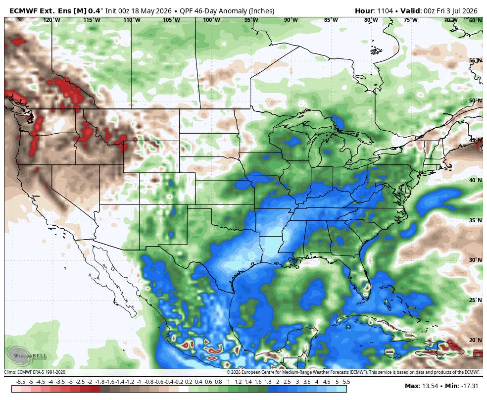
This is exactly what we need. Ample supply of gulf moisture. Sent from my SM-G998U using Tapatalk
-
looks like we should get clipped with some garden variety rains here before too long, could use the rain too
-

2026-2027 Strong/Super El Nino
40/70 Benchmark replied to Stormchaserchuck1's topic in Weather Forecasting and Discussion
Hopefully that helps boost the RONI. -
This for sure!
-
Drought forever
-

2026-2027 Strong/Super El Nino
snowman19 replied to Stormchaserchuck1's topic in Weather Forecasting and Discussion
+IOD incoming, which will constructively interfere with the developing El Niño and will help to enhance the equatorial westerlies. I think this is the combo that finally sloshes the Indo-WPAC warm pool east…… -
Yeah I would not be shocked to see some heat advisories tossed out this afternoon
-
I suspect we get heat advisories added in the springfield to HFD and also metrowest of Boston for tomorrow. The 2ms appear under cooked for the fact that the 850 mb will be reached as the mixing depth and I'm seeing 19C at that level on some of this guidance. All but compelled to add 2 point bump out of respect for superb heating combined with "non-Markovian" feedback, no less.
-

2026 Spring/Summer Mountain Thread
Maggie Valley Steve replied to Buckethead's topic in Southeastern States
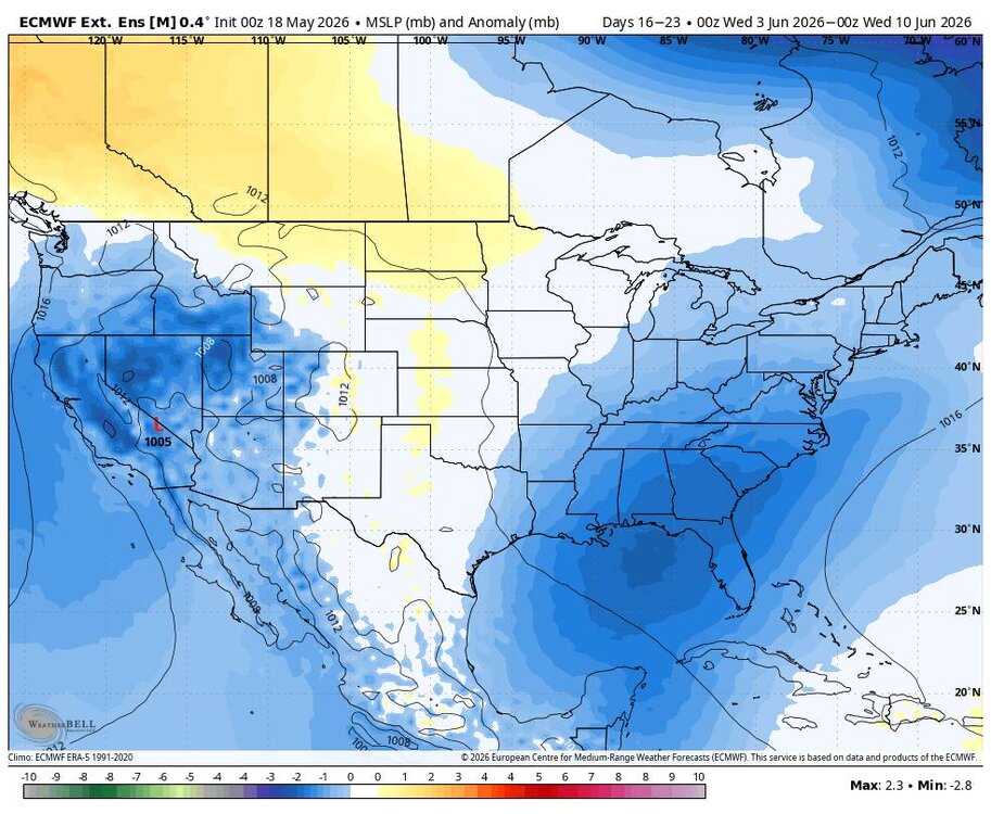
It looks like a significant pattern change is coming this week with a stalling boundary that will extend back into Texas. Rounds of rain will move across the Mountains later this week and possibly into the weekend. I'm seeing a pesky trough building in and lowering pressure across the Gulf as a monsoonal trough begins to organize in the Western Caribbean. Our sensible weather suggests that we begin to see an El Nino pattern slowly become established and rain chances increase all across the SE Region. Keep an eye on an early tropical system slowly organizing somewhere in the Gulf at the end of May or early June. -
Great point on this...strength of the flow certainly does factor in. Also, in this case as least that boundary is probably so shallow and weak that its just totally mixing out
-
I expected the temperature swings to be done by now. I haven't seen a spring as bipolar as this one (I wonder if it's due to there being a really cold winter and the ocean temps are cold), and I'm starting to worry it will bleed into summer. We've had 80 degree days followed by 30 degree ones, 90 degree days followed by 40 degree ones, and now 95 degree days followed by 50 degree ones.
-
Welp .. 75 here as we pass into the 10am hr "10 after 10" puts us in the 80s ... but being on the north side of a sag front that has observable site winds coming off the ocean. That says no...but, temps rising unimpeded as trend says yes. Minor competing signals there. I guess the wind being very light, in the 10kt range may not be enough. It's like you could work it out mathematically. Determine what the necessary E wind strength has to be during the solar max in order to overcome diurnal heating. I bet 10 kts isn't enough? Something like that. The shallow boundary is already apparently coming back as a warm front, according to WPC ... the previous update had this as a cool front where it is now warm in CT. I guess the late high T surge idea of the NAM has legs.
-
That's been the trend all spring. The only appreciable rain we've really seen was the 5/9 event and maybe something else in April.
-
Well I'm very curious to see how well NBMv5 performs. 7z NBM for BDL has 99 for a high tomorrow (though highest 3-hr temp is 94) with a low of 73. MAV is 92/67 MET is 91/68
-
Its funny, I was reading something a little while back that Dandelions really aren't a great food source for our native bees. No Mow May can provide some benefits with natural food sources with native stuff, but we also have a lot invasive weeds that can spread a ton of unwanted weeds seeds as well (that are not any benefit for pollinators and can be aggressive in spreading). I'm not saying a perfect manicured lawn is a better option, but there are definitely are a lot native perennials and shrubs that you can plant that provide a better food source for most of our native pollinators.
-
Looks like this storm is further north than projected. Models drying up south and east of Denver. But look like a heck of a snowstorm in Wyoming
-
Once we get to June its pretty rare to have highs below 70
-
It'll be closer to a nothing burger by then since that's usually what happens as events draw closer. I can see it turning out windy and raw with on and off light rain, similar to last week, but not much appreciable precipitation, which will still suck for Memorial Day.
- Today
-
I hope this isn't a preview of summer. I'm just tired of these wild temperature swings. I'd much rather have it be one consistent temperature, whether it be the 90s, 80s, or heck, even 70s. But I can't do it if we're going to have runs in the 100s this summer, only to be followed by temps in the 50s soon thereafter.
-
The euro is absolutely horrendous. Hope that changes.
-
Nah its a holiday weekend so of course it will be a washout
-
Someone who knows his stuff ∆
-
Maybe a few rogue strong storms around later Tuesday. We'll see convection with the front on Wednesday but anything severe would be isolated and relatively brief. Would be more intriguing if lapse rates were a bit more respectable.