All Activity
- Past hour
-
88.2 at my house. Should squeak in the 90 for a minimum heat wave.
-
The Latest HRRR says what rain.
-

2025 Atlantic Hurricane Season
BarryStantonGBP replied to BarryStantonGBP's topic in Tropical Headquarters
I give up The funniest name wasted
-
 we used to get entire summer months that didn't hit 90
 -
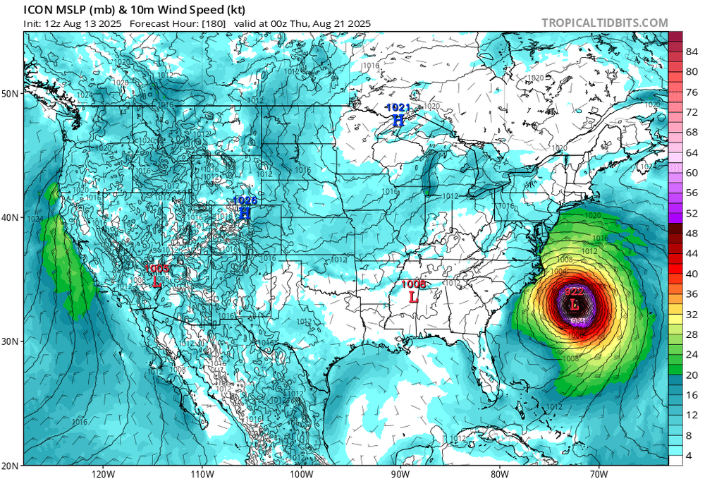
Now know the ICON is not a tropical model Ensembles are all in agreement. A swing and miss...no extra innings for this baby! NEXT
-
~25 total ACE for those 3 progged storms, combined
-
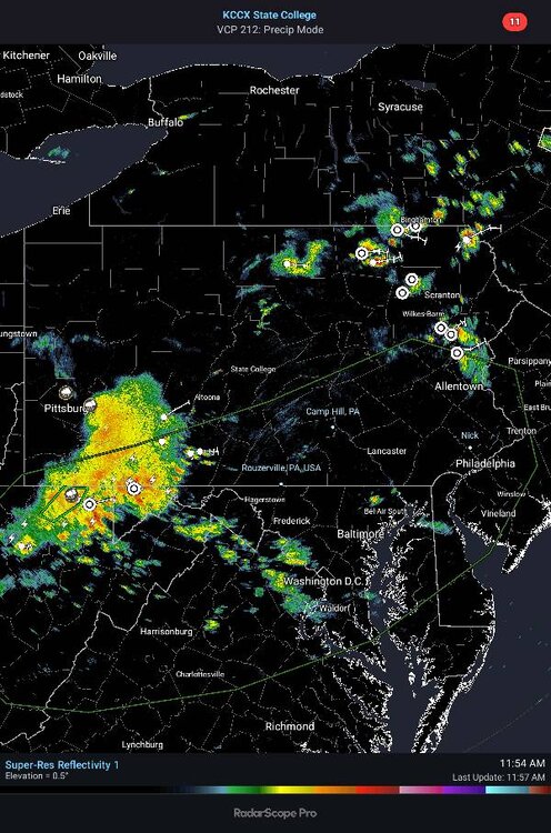
And I'm hearing thunder, a bit east of New Milford, CT. Looks like a small blip on the radar, but I'm a happy camper. Nice little wind burst ahead of the rain getting here.
-
2025 Atlantic Hurricane Season
BarryStantonGBP replied to BarryStantonGBP's topic in Tropical Headquarters
How much ACE would that be between storms I give up. The funniest name wasted -
Central & Eastern Pacific Thread
BarryStantonGBP replied to Windspeed's topic in Tropical Headquarters
Apparently peak season favours Lilo and Stitch over Gabrielle and Humberto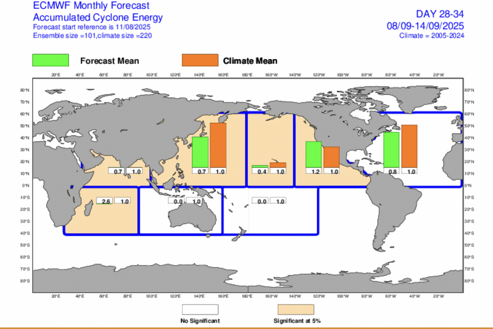
-
88.8° Should reach heat wave status today
-
I’m glad you asked because despite the 80% of 2005-24 avg ACE, it’s predicting ~3 NS for Sep 1-14. That’s actually slightly above the 2005-24 avg of 2.5 NS. That implies shorter tracks/possible W basin.
-
-
 Yeah the current one is pretty lame. No 95+ so it gets a 1 out of 5
 -
I’m shocked there wasn’t a flood watch this week. I think we’re under our third flash flood warning of the week
-
Finally got rain, but just 0.59". I have been screwed on almost everything event this summer. Better now than winter.
-
Flood Watch National Weather Service Baltimore MD/Washington DC 1157 AM EDT Wed Aug 13 2025 DCZ001-MDZ006-008-011-013-014-504-506>508-VAZ053-054-140000- /O.NEW.KLWX.FA.A.0032.250813T1800Z-250814T0100Z/ /00000.0.ER.000000T0000Z.000000T0000Z.000000T0000Z.OO/ District of Columbia-Northern Baltimore-Cecil-Southern Baltimore- Prince Georges-Anne Arundel-Central and Southeast Montgomery- Central and Southeast Howard-Northwest Harford-Southeast Harford- Fairfax-Arlington/Falls Church/Alexandria- 1157 AM EDT Wed Aug 13 2025 ...FLOOD WATCH IN EFFECT UNTIL 9 PM EDT THIS EVENING... * WHAT...Flash flooding caused by excessive rainfall is possible. * WHERE...Portions of DC, including the following , District of Columbia, Maryland, including the following areas, Anne Arundel, Cecil, Central and Southeast Howard, Central and Southeast Montgomery, Northern Baltimore, Northwest Harford, Prince Georges, Southeast Harford and Southern Baltimore, and northern Virginia, including the following areas, Arlington/Falls Church/Alexandria and Fairfax. * WHEN...Until 9 PM EDT this evening. * IMPACTS...Excessive runoff may result in flooding of rivers, creeks, streams, and other low-lying and flood-prone locations. Flooding may occur in poor drainage and urban areas. * ADDITIONAL DETAILS... - Thunderstorms are likely this afternoon into this evening with heavy rainfall within a short period of time. Localized rainfall amounts around 1 to 2 inches within an hour are likely. Multiple rounds of storms are possible with total rainfall amounts around 2 to 4 inches. This may cause creeks and small streams to rise out of their banks with flash flooding possible. - Please visit www.weather.gov/safety/flood for flood safety and preparedness information PRECAUTIONARY/PREPAREDNESS ACTIONS... You should monitor later forecasts and be prepared to take action should Flash Flood Warnings be issued. && $$ AVS
-
2025 Atlantic Hurricane Season
BarryStantonGBP replied to BarryStantonGBP's topic in Tropical Headquarters
How much NS would that be then just for housekeeping -
Never count out the BoC
-
It would require a dramatic shift for this to threaten the US east coast. It’s pretty much gone at this point.
-
This looks promising Sent from my SM-X210 using Tapatalk
-
Fernand strikes me as a gulf quick fire name
-
Haha that line was 100% frustration from looking at my seasonal snow total this morning. It is regression and I do agree that in general winter produces most here looking at the longer arc of time. Doesn’t change the pain of losing nearly a decade to some historically bad winters. That’s time you don’t get back.
-
 Conceptually, it could be done. I suspect that reasons that such classifications have not been pursued are the additional elements of duration and nighttime temperatures that help define heatwave severity.
 -
The Bay of Campeche/SW Gulf has often over performed. A TC from this wouldn’t at all surprise me. The NHC is probably too low with its percentages.
-
2025 Atlantic Hurricane Season
BarryStantonGBP replied to BarryStantonGBP's topic in Tropical Headquarters
All for the bloody peak season energy to go into the EPAC what’s the point