All Activity
- Past hour
-
Taking advantage of this lower humidity and temp day. Lunch back out on the deck. And the cats are happy the catio is back open. Beautiful breeze right now.
-
GFS is so bad. Remember when it had the MCS cutting into NY State 2 days ago? LOL.
-
46kts ORH earlier
-
What I think also gives this more support is the NBM doesn't look to be overmixed wither...still has upper 60's to lower 70's dewpoints. The NBM tends to be lower with dews. I guess though if we end up seeing dews more 72-73 versus say 68-71 then we may be more 99ish versus 101-102ish.
-
Interesting how many balloons and radiosondes were deployed or utilized in 30s-40s and 50s to get regional or national 500MB observations. Id argue those heat domes were just as high then with those readings.
-
Here are the percentiles. This is a pretty damn good signal for highs to get into the 100's in the hottest spots. Not sure how much this applies to our area but in these anomalous heat patterns...those 70th-90th percentiles usually work out. This has with some of those big heat events within the West anyways...again not sure if that can be applied here.
-
Yeah just a quickie. Upslope is already drying up. Gonna go right back up by Sunday.
-
Remembering last June’s heatwave, I seem to recall there was an afternoon or two that we got some nice outflow that made things feel quite pleasant in the late afternoon, even in areas that didn’t get storms.
-
Do you think that these days.. analogs are getting less relevant? Sure feels like it, but hey I'm just an amateur hobbyist here, lol
-
Another way that we can look at how the tree growth over the NYC ASOS has artificially cooled the summer highs there since the 1990s is the comparison between Newark and NYC high temperatures on the warmest day of all the decades since the 1930s. Into the 1980s NYC would often be warmer than Newark on the warmest day of the decade. But the relationship shifted during the 1990s when the NYC ASOS was moved under the trees. Now Newark is always warmer on the warmest day of the decade than NYC. The current warmest day of the 2020s is 6-30-2021. Newark reached 103° with NYC only reaching 98°. So NYC was 5° cooler. Next Tuesday could be the warmest day of the 2020s so far. So it will be interesting to see if Newark can rival or even exceed the +5° warmer than NYC in 2021. Warmest day of the decade comparison between NYC and EWR 6-30-2021 EWR….103°…..+5° NYC….98° 7-21-2011 EWR….108°…..+4° NYC…104° 8-9-2001 EWR…105°……+2° NYC…103° 7-10-1993 EWR….105°…..+3 NYC….102° 7-21-1980 NYC….102°…..+1° EWR….101° 7-21-1977 NYC…..104°……+2° EWR…..102° 7-23-1966 EWR…..105°….+2° NYC…..103° 9-3-1952 EWR…..105°…..+2° NYC…..103° 7-4-1949 EWR….105°…..+3° NYC….102° 7-9-1936 NYC…..106°….+2° EWR….104°
-
Cold pool rapidly moves out at least
-
78 / 57 and breezy
-

E PA/NJ/DE Summer 2025 Obs/Discussion
Hurricane Agnes replied to Hurricane Agnes's topic in Philadelphia Region
LSR is up and it seems the max gusts reported were ~55 - 60 mph - https://www.weather.gov/wrh/TextProduct?product=lsrphi Just looking at pics of literal "snapped" trees and poles (versus the usual uprooting) seems to suggest that there might have been some localized downbursts/straight line winds at some locations. I bottomed out at 64 this morning and it's like day and night compared to yesterday (with steamy windows). It's currently mostly sunny and breezy, with temp at 79 and dp a more manageable 64. Furnace will be incoming soon though! -

2025-2026 ENSO
40/70 Benchmark replied to 40/70 Benchmark's topic in Weather Forecasting and Discussion
Damn, Philly has fast...was about to post the IRI update lol. Looks like El Niño is off the table...gonna either be cool neutral or weak La Niña, but given what we know about the state of the globe...probably wise to err on the side of caution and assume weak La Niña type of net impact. That said, what last season taught me is don't ENSO be a prohibitive factor in your analysis and discretion with analogs....ie, if you see strong value in a season, then go ahead an include it...even if its neutral or warmish ENSO. There is no way anyone could have had the Aleutian low reflected in their forecast composite for last season had they restricted themselves to solely cool ENSO seasons. -
47F at top of the Gondola, 57F at the base. Windy with occasional squalls. Summer ops start tomorrow. A good 25F cooler than yesterday.
-
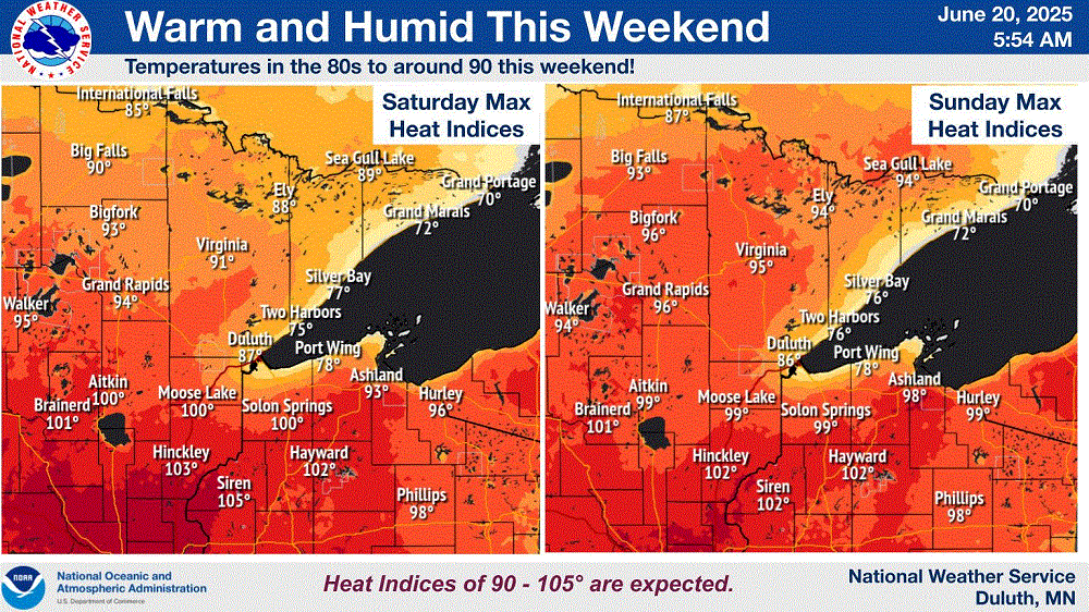
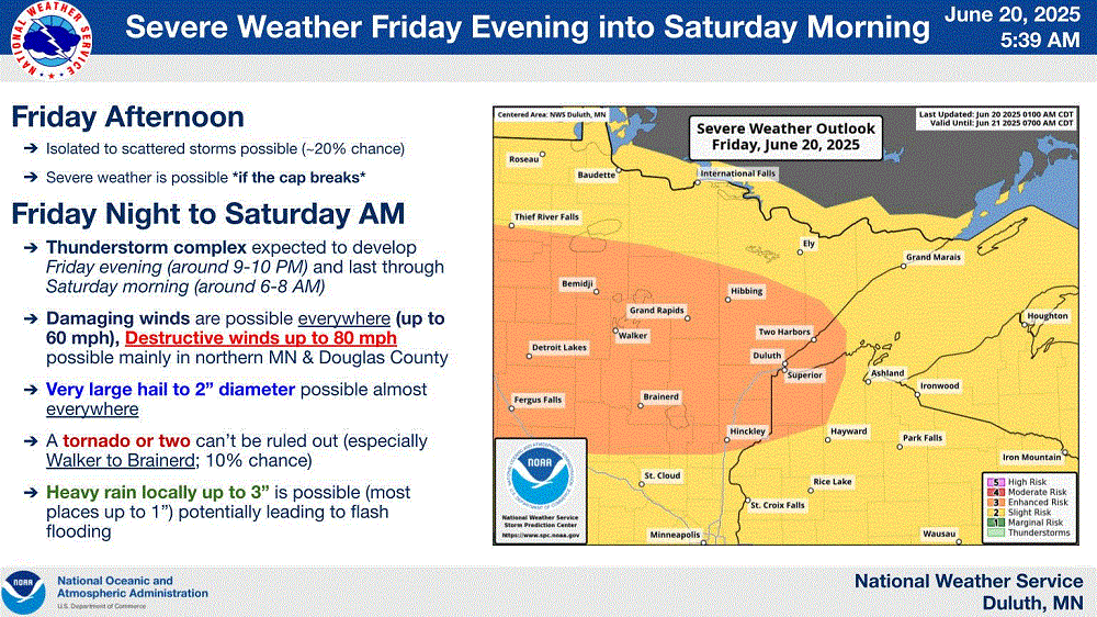
The Northshore awaits you & fam. I get to escape the nasty heat this weekend. TY Lake Superior! (I bet half of the state will be up here LOL) Rough stms possible tonight.
-
Can’t wait to watch that fail in storm threats all winter. I’m sure it will nail a 1040mb high within 0.1mb though.
-
Well if our president doesn't destroy us, AI will.
-
-
Exactly, getting to 98 or 99 is as annoying as a 98 or 99 on a test. 100 is perfection in both cases, so that would be ideal. 105 for extra credit lol.
-
Great news. I don't really care about Monday, maybe we'll finally have an exceptional day, not the mediocre heat of every summer since 2013.
-
I hope we hit 103 or 104 next week to tie or break the June record. If it's going to be tremendously hot, we might as well make it historic instead of just upper 90s to near 100. Very nice to get the break in the humidity today though. Feels good out there with dewpoints in the 50s. With sunshine and temps going to the mid 80s, this is a top 10 type of day for the summer. Perfect for outdoor activities.
-
Finally a free source has the 6z Euro. It looks like there's an ocean wind on Monday keeping the bad heat inland. Tuesday the winds go NW and everyone torches full blast.
-
After curb stomping us during winter, this is when we can +1 you guys lol.
-
Down there. Up here its currently 60.4°/56.5° overcast an breezy.


