All Activity
- Past hour
-

12/14: Sunday funday? Will the south win again?
stormtracker replied to TSSN+'s topic in Mid Atlantic
DCA on some ol bullshit. Same as it ever was. -

Central PA Winter 25/26 Discussion and Obs
Blizzard of 93 replied to MAG5035's topic in Upstate New York/Pennsylvania
I just looked back at the posts & didn’t see anything more than usual snow event banter & Observations. -

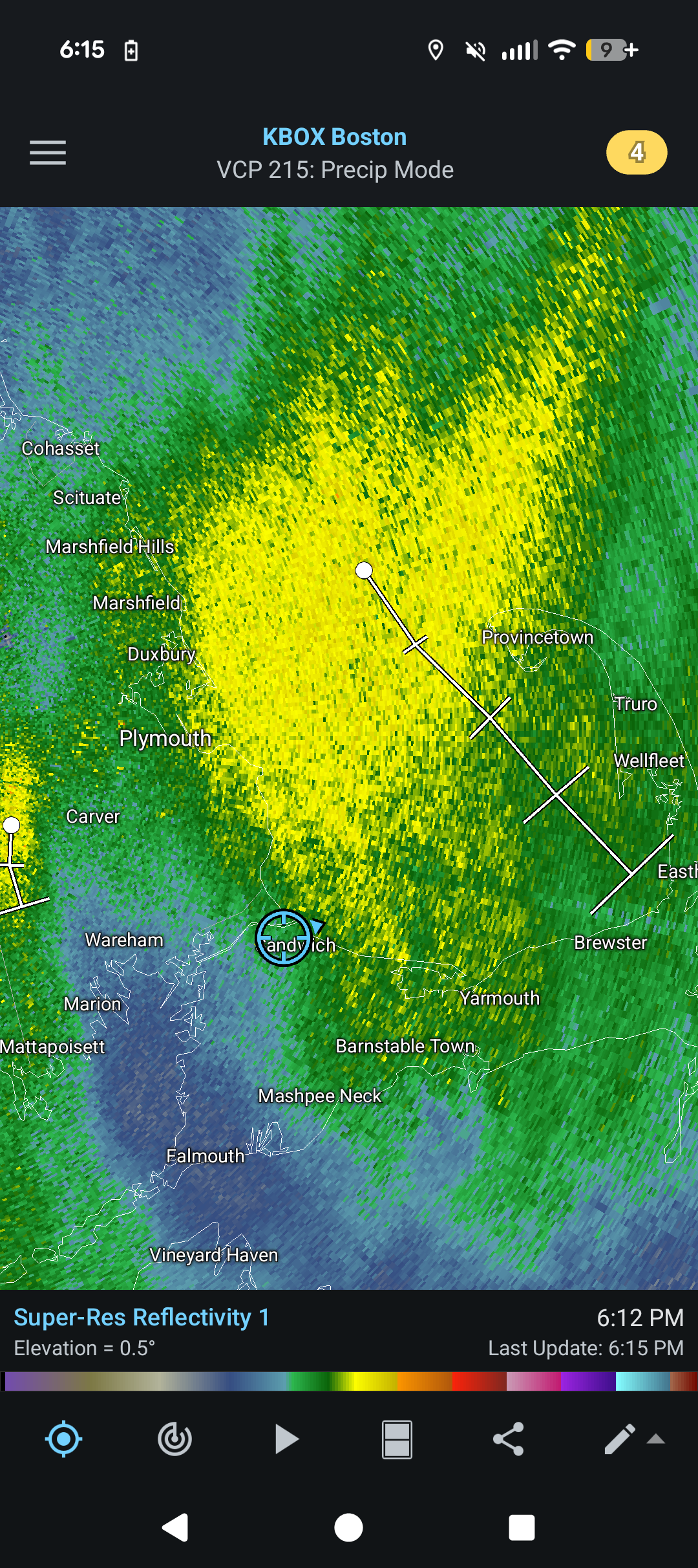
December 14th - Snow showers or Plowable snow?
ineedsnow replied to Sey-Mour Snow's topic in New England
you crushed soon -
Nice. The Commack/Dix Hills/East Northport area all came in between 8 and 8.5”. Love to see that kind of verification. also nice to be the jack for the storm lol
-
Temps dropping steadily. Down to 15 here.
-
December 14th - Snow showers or Plowable snow?
ineedsnow replied to Sey-Mour Snow's topic in New England
That's awesome!! hope they get crushed!! -

December 14th - Snow showers or Plowable snow?
Boston Bulldog replied to Sey-Mour Snow's topic in New England
James would always be able to call when these sliders would trend north… the fact that he thought every storm passing south would trend north into Harwich notwithstanding -

December 14th - Snow showers or Plowable snow?
SouthCoastMA replied to Sey-Mour Snow's topic in New England
Oh how we pray that clips me. Wish I lived about 5-10 miles east for this
-

Central PA Winter 25/26 Discussion and Obs
Voyager replied to MAG5035's topic in Upstate New York/Pennsylvania
Absolutely. I saw it the same way you did. -

Central PA Winter 25/26 Discussion and Obs
mahantango#1 replied to MAG5035's topic in Upstate New York/Pennsylvania
-

December 2025 Short/Medium Range Forecast Thread
Carvers Gap replied to John1122's topic in Tennessee Valley
And be sure to keep posting! Great to have our input...I meant to add that. -
December 2025 Short/Medium Range Forecast Thread
Carvers Gap replied to John1122's topic in Tennessee Valley
Yep. Get rid of that feedback over the Pac NW, the vortices kick eastward, and deepen. For whatever reason, models are having a very difficult time (past 5-6 weeks) with infinite vortices over the West Coast. That error is rendering modeling almost useless after hour 200...not that it is super accurate after that during normal times. @John1122got me into watching Mammoth's snow cams during winter. I follow a bunch of their pages after the Carver Gap family visit over the summer. That place is beautiful at all times of the year. Anyway, they are stuck under that western ridge. -
Central PA Winter 25/26 Discussion and Obs
Blizzard of 93 replied to MAG5035's topic in Upstate New York/Pennsylvania
See my post above. I have no idea where he got that idea. It was clearly a couple a long time posters joking around. -

2025-2026 Fall/Winter Mountain Thread
Buckethead replied to Buckethead's topic in Southeastern States
Currently at 2°. Sent from my SM-S908U using Tapatalk -
In my neighborhood we had about an inch. Streets were covered and so was grass near the end of the storm. I call hoo on .3".
-
Central PA Winter 25/26 Discussion and Obs
Voyager replied to MAG5035's topic in Upstate New York/Pennsylvania
I, and I doubt that anyone other than YOU, didn't see it as a character assassination at all. -
December 14th - Snow showers or Plowable snow?
Boston Bulldog replied to Sey-Mour Snow's topic in New England
The Dawn Awakening -

-
HoCo 2 hr delay! Only important since my wife just did cartwheels with a backflip to celebrate it.
-
Please post when it pleases you to do so. No reason to keep to a schedule for us knuckleheads. Best of health to you too.
-

December 14th - Snow showers or Plowable snow?
Bryan63 replied to Sey-Mour Snow's topic in New England
Really nice stretch right now, better than anything earlier. -

December 14th - Snow showers or Plowable snow?
Diggiebot replied to Sey-Mour Snow's topic in New England
Little James nichols special -
.thumb.jpg.6a4895b2a43f87359e4e7d04a6fa0d14.jpg)
Central PA Winter 25/26 Discussion and Obs
Yardstickgozinya replied to MAG5035's topic in Upstate New York/Pennsylvania
The whole points of my argument was never the amount of snow.I think it's pretty obvious from last night that it tapered off pretty quick from harrisburg to etters and the fact that you all keep trying to make it the point speaks volumes to those that know how to read. -
Central PA Winter 25/26 Discussion and Obs
Blizzard of 93 replied to MAG5035's topic in Upstate New York/Pennsylvania
If you are referring to me, I was joking around with @canderson last night when I asked if he had some beers. He has posted many times over the years about having some weekend or travel drinks. He had bad luck with snow in the city last night & I was joking around with him. I don’t recall any attempt at him coming after my or anyone else’s character. We go way back on here, so I was just having a little fun, but I believed his observations. Now that I know he’s done with drinking at this time, I won’t joke about it anymore. Let’s keep the peace in here please. We have a good group. -
December 2025 Short/Medium Range Forecast Thread
Carvers Gap replied to John1122's topic in Tennessee Valley
I think as soon as a model spins up a low over the Canadian Rockies, sends it SW to where is spins off the CA Coast until it strengthens anomalously, and then dies out...has to be tossed right at the point. The 18z GFS makes a lot of sense until it does that at 210. Those solutions haven't been materializing. When the feedback occurs, it spins up a deep trough in the eastern Pac(which originates in Canada!) and that deepens the AN heights over the EC and ensuing Chinook. Those western Canadian coastal lows are going to get kicked eastward - just how it goes in real life "most" of the time. I think that problem is over cooking the ensembles.