All Activity
- Past hour
-

October Comes Early: Late September Multi-Hazard Hybrid Storm
NW_of_GYX replied to WxWatcher007's topic in New England
Howdy friends, is my flight home into PWM getting canceled Sunday afternoon or na? -

Strong Nor'Easter/Hybrid Storm Late September 2026
NJwx85 replied to Rjay's topic in New York City Metro
He’s a tool. The reason it weakens is because it becomes vertically stacked and occludes, because it’s cold core. Tropical systems don’t weaken when they become stacked. -

October Comes Early: Late September Multi-Hazard Hybrid Storm
WxWatcher007 replied to WxWatcher007's topic in New England
I agree. That's why I think it's important to let the science do the speaking. I'm no met obviously, but I still think it's possible to communicate meteorology in a way that doesn't add all the extra nonsense that pushes people from being effectively informed in the first place. But I think the lack of any mention by the NHC is a pretty significant tell at this stage. Maybe we get some late acknowledgement from them as the system is developing, but I'm not counting on it. Back to the system...even though it's shallow, if anything the GFS and Euro are more aligned on this being warm core than they were a few days ago. We don't get these often, and I'd argue that it's not insignificant if we see this really consolidate as it's crossing the Gulf Stream and organizing on Friday. If this takes longer to pull together it's weaker and more strung out and more mundane...but we don't see this signal often. -
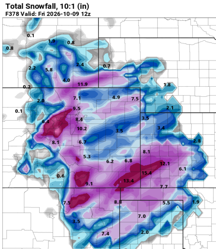
GFS fantasyland maps, how I've missed you
-

October Comes Early: Late September Multi-Hazard Hybrid Storm
WinterWolf replied to WxWatcher007's topic in New England
He loves absolutism….and it’s backfired on him more than once. -

October Comes Early: Late September Multi-Hazard Hybrid Storm
vortex95 replied to WxWatcher007's topic in New England
When dealing w/ outlier events, you need to think outside the box! Odds often are more surprises than usual, so be careful about absolutisms like "this will be nothing like." I brought up Oct 2021 b/c it looped back toward the coast. This storm will likely do the same. That does not mean G113mph on Cape Cod, but such movement for a nor'easter is not typical, so I say again, be careful! Want to know another storm (actually hurricane once reanalyzed) that looped back in and resulted in winds way higher than fcst? Dec 23, 1994. I'm sure a 15 y.o. Scott was taken aback by that in GHG! -
 mexican pharmacy online or mexican pharmacies shipping to usa mexican drugstore http://www.gubanr.com/export.php?url=http://solmedsdirect.com farmacia pharmacy mexico delivery to usa or http://www.orangepi.org/orangepibbsen/home.php?mod=space&uid=7036066 mexican pharmacy prescription savings [url=http://vmus.adu.org.za/vm_search.php?database=vimma&prj_acronym=MammalMAP&db=vimma&URL=http://solmedsdirect.com&Logo=images/vimma_logo.png&Headline=Virtual]order meds from mexico[/url] pharmacies in mexico or [url=http://www.1gmoli.com/home.php?mod=space&uid=1108130]legit mexican pharmacy[/url] mexican pharmacy online ordering
 -
65.7 for a high and 59.8 currently
-

Septorcher 2026 Discussion - Endless Summer
alex replied to Damage In Tolland's topic in New England
Foliage is moving along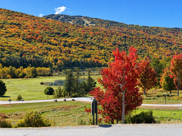
-

October Comes Early: Late September Multi-Hazard Hybrid Storm
weathafella replied to WxWatcher007's topic in New England
It’s on deck circle replacement is quite different -
October Comes Early: Late September Multi-Hazard Hybrid Storm
vortex95 replied to WxWatcher007's topic in New England
If 1938 occurred again, the biggest issue would be WITHDRAWAL b/c no power and thus no access to AmrWx! Even when you got power back (a month later for many), don't expect Internet back nearly as "fast!" And even when it comes back, it likely will be ridiculously slow for many for awhile. 56k Telebit modem anyone? -
October Comes Early: Late September Multi-Hazard Hybrid Storm
vortex95 replied to WxWatcher007's topic in New England
You wrote: "The constant "meh" stuff has gotten beyond old" Re: @CoastalWx LOL! I agree 100% w/ @FXWX. Signal to noise ratio needs to be kept in check. Not saying you can't have levity or snarky posts, just don't let it get out of control. Sometimes I think an upcoming wx event causes more anxiety and nervousness than anything. I admit, I get a bit anxious when a big event is coming up, and you know what that is often?, trying to keep up w/ it all! I don't want to fall behind! And you have be careful b/c it consumes SO much time, and it flies by. It's just information overload these days, and it is a big challenge. So I welcome a quiet stretch every so often (even "BORING" Scott!). -
The way the Mets fans reacted when he went back to Queens tells you everything about him and how pissed off Mets fans are lol.
-
Charlottesville / UVA is so pretty!
-
legitimate canadian online pharmacy [url=https://canamcrosscare.shop/#]СanAmCrossCare[/url] canadian pharmacy official site
-

October Comes Early: Late September Multi-Hazard Hybrid Storm
LSC97wxnut replied to WxWatcher007's topic in New England
NAM and all, but maybe not a complete washout for parts of SNE? -
October Comes Early: Late September Multi-Hazard Hybrid Storm
vortex95 replied to WxWatcher007's topic in New England
And we know how the 3 km NAM handles tropicals. I recall in the late 2010s, it shows a 860 mb system in the Gulf, and it ended up a min HU (barely). And goes to show how ignorant or disingenuous some are on social media. They either have no clue of model limitations or know all to well, but show an extreme model solution anyway b/c it gets clicks/likes. -
October Comes Early: Late September Multi-Hazard Hybrid Storm
vortex95 replied to WxWatcher007's topic in New England
You wrote: There's a lot of social science and understanding the psychology of the general public that needs to be considered to get people to act appropriately. It is what it is. The problem here is that it has been adopted "more is better." No, it is not. Ever hear of the boy who cried wolf? There comes a point of diminishing returns, and that is in form of apathy and the public having no way to scale or quantify any wx events, it is always "catastrophic" or "extremely dangerous." Run-of-the-mill storms, and you'd think the world was ending. Yes, social media does this but over time, I have see Federal agencies adopt this wording as well. It may be it is what is, but that does not mean it is right or beneficial. On the more specific musing for the upcoming storm... My issue is that they (NHC) are letting non-wx/science issues compromise the hard met science. And my criticism does not mean I do not respect NHC. I do. But you can show respect and still criticize or point out issues. The problem is that sometimes they or any agency will get all bent out of shape and defend/deflect to the end when ppl bring up valid points and issues. Recall the push-back from the NWS when ppl were upset and calling out the lack of a TOR for Springfield MA in 2011? 10 minutes late. Yes, I know the issues as it was discussed on this group, but my biggest issue is how they handled it w/ snark and some could say plain vitriol. Don't insult our intelligence, it was messed up big time for number of reasons, so fess up and take responsibility. Getting back to NHC, some years ago, I was told by a Lead Met at a NEUS WFO, NHC does not handle TCs outside the tropics and subtropics well, not when it comes to risk and watches/warnings. You can't treat a TC at mid-latitudes like farther S. Asymmetries, accelerations and baroclinic effects make them much more variable than in the tropics. I recall one event from 2009 or 2010 (HU Bill or Earl). They had TS warnings as far W as BDR. This was for a TC that clearly was going to stay E of Cape Cod. So w/ such warnings up that far W, the probability of *sustained* TS winds (not gusts) is extremely low. And we know for many TC recurving offshore, the winds on the W side are significantly reduced due to the asymmetrical wind field and the storm's forward acceleration. Putting up such warnings is non-trivlal, it has huge business and commerce impacts. TC forecasting and modelling has immensely advanced in the last 30 yr alone, yet I do not see us taking full advantages of that for watches/warnings. It's still overdone often. Not every TC situation is the same, so you can not apply general standardized rules as if it is "one-size fits all." What may occur for this upcoming storm may be something we have not seen before (STS develop from a ET low near the NEUS coast) and I would say it is not a very low probability event. What, do you just ignore that completely b/c you are worried about this or that? Forget social media, and just do you job and stick to the met science. -

Strong Nor'Easter/Hybrid Storm Late September 2026
GaWx replied to Rjay's topic in New York City Metro
Joe Bastardi, who I often don’t agree with, continues to insist this will transition from baroclinic/cold core to warm core Fri night/early Sat leading to an “eye-like feature” and says it thus should be named. He says the NHC is wrong in not even putting it in its TWOs. He shows the Euro ensemble giving it a 70% chance for tropical development. He said there will be rapid feedback over SSTs that are abnormally warm (well above 79F) due largely to GW. Per JB, evidence of it being warm-core is that it starts to weaken as it moves NW into cooler SSTs followed by it dissipating as it makes landfall. Also, he posted the Euro having a warm center offshore on Sun AM at 700 mb! He shows 1000/500 mb thicknesses peaking at the center at >576 dm! He compares this projected weakening over cooler SSTs to Henri of ‘21 as it approached the NE. He said tides may go as high as 3-6 feet AN at NYC! Does anyone here recall a purely cold-core nor’easter in this region this early in the fall? Aren’t those usually not til Oct, when SSTs aren’t as warm? -
2026 C and E Pacific tropical activity
WxWatcher007 replied to GaWx's topic in Tropical Headquarters
Polo is back in a big way. Not often we see a hurricane lose C5 status and come back like this. -
Fall 2026 Medium/Long Range Pattern Thread
Daniel Boone replied to John1122's topic in Tennessee Valley
Picked up over 2 inches of Rain (2.25) here from 6 to 8 this Evening. Prior to this, I had recorded only .98 for the Month. Western Lee County has done well with 5-6 inches for the Month. -

October Comes Early: Late September Multi-Hazard Hybrid Storm
Ginx snewx replied to WxWatcher007's topic in New England
I have some data on my page. No graphics - Today
-
October Comes Early: Late September Multi-Hazard Hybrid Storm
Ginx snewx replied to WxWatcher007's topic in New England
Hammer forgets the far eastern part of the state every big storm that misses HFD -
Been steadily raining this evening, but I think y’all got more to my west again. Just shy of 1.5 inches now since midnight, but hardly any returns on radar.
-

Strong Nor'Easter/Hybrid Storm Late September 2026
FPizz replied to Rjay's topic in New York City Metro
Why though? You can pick who you follow on each. Your fault for following trash.