All Activity
- Past hour
-
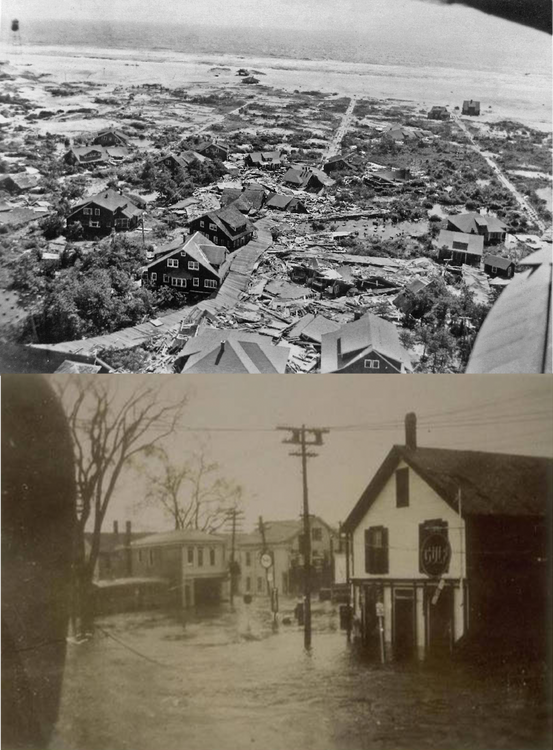
Some debate about if 1635 was worse than 1938... I know it pushed a lot of water ahead of it. With CC and all, it does lend to the idea that a more powerful storm could survive up here
-

-

2025-2026 ENSO
40/70 Benchmark replied to 40/70 Benchmark's topic in Weather Forecasting and Discussion
I'm in the 50's and cloudy today...great yard work weather. -
*WAS terrible. 1635 was the GOAT though, something like that could be improbable damage. Ideally it is like Hurricane Carol but 15-30mph stronger and much larger, like a mini Typhoon Tip <3
-
For up here? ... I know the mud scrolls or whatever hint at pretty powerful storms in the 1400s or whatever... Not sure we could top a 1938
-
2025-2026 ENSO
40/70 Benchmark replied to 40/70 Benchmark's topic in Weather Forecasting and Discussion
I think it snip my scrotum and use it to tie a noose to hang myself with. -
1938 was terrible but I mean, aren't there worse possibilities?
-
Yeah I’ll pass.
-
-
It's such a small area that a sizable storm line covers most of us.
-
We take!
-
Getting a little bit .06
-
Tough sell/science for now ... ( and I realize you're not asking me directly - ) but, I've surmised it may be related to C02 growth in the atmosphere, exceeding absorption rate/capacity of the oceans. With more C02 left available to store tropospheric heat, that effects heat exchange efficiency in the total atmosphere/ocean coupled model. How? A warmer C02 richer atmosphere increased WV loading, and above some mass, this slows the evaporation rate off the ocean, which physically transports heat away with the evaporating mass... This slows ocean cooling, ...such that heat absorption exceeds heat escaping --> temp goes up. Probably? approaching a critical mass threshold where we all die. Have nice day /// 2023 didn't just happen for shits and giggles. And the ITZ SST band only dropping .6, while the Sub -T SSTs tickle history, means the total region is actually not going down.
-
Soaking wet today in the march in nyc. But it is like 65 so super pleasant.
-
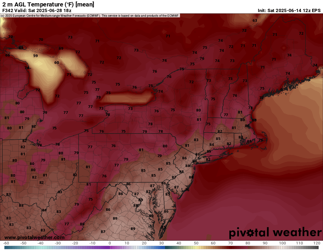
That period starting late week/early the following week does look like the first decent shot of a heat wave for SNE. Maybe even 4-5 days in the 90s
-
How often is severe weather "widespread", though? Isn't it somewhat scattershot by nature?
-
Not one peak of sun here today and it's back to misery mist.
-
I know the privy folk won't like this, but I would not wish away a FM strong cat 3- borderline 4 (130-140? mph weakening to 120) rocketing forward N or even NNW <3 into SNE.
-
The SST's were always 78F if not 83F peak, saw and measured those every year I used to measure from the late 80's through 2005. The "good" years you can bake some inlets to 80's easily - EWB, West Fal., and so on. It's basically a 1000 or 10,000 /year miracle to rip a cat 3-near 4? up into NE? lol
-
I can hear thunder but radar says i miss this blob. Doesn't look like my weekend but it's still early
-
at least for now there's what appears to be a decent couplet on that cell north of Winchester... TVS indication per RadarScope
-
it looks like the sun has been trying to come out
-
Smoke was horrible in Essex today for my sons baseball tournament
-
The diabolical miscreant dystopian ahole in me would rather it be August 21 ...right about on lolly-pop top of the highest OHC climo available around New England coastal waters, after (say) a Hades summer really cooked the shit to historic SSTs. Hell, I remember once swimming/surfing Narragansett Beach in southern RI and the water temp at the buoy/mouth of the Bay just around the corner was 81 ... Granted, it was more like razor thin 74 out in the Bite water S of L.I. but if you're trying/hoping to conserve as much jesus h christitude of storm momentum as possible, September is already starting to create just that much stabilizing marine boundary layer to steal some greedy wind points away. lol
-
This looks maybe average to slightly above for the end of June.. nothing crazy