All Activity
- Past hour
-

The Jan 31 Potential: Stormtracker Failure or 'Tracker Trouncing
Amped replied to stormtracker's topic in Mid Atlantic
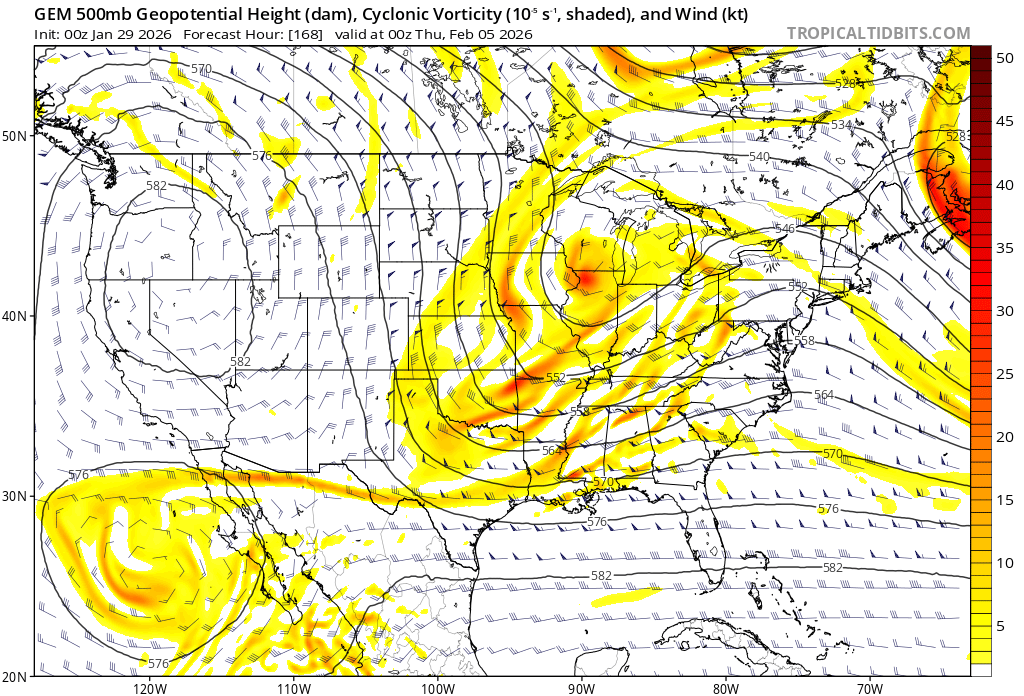
The 500mb evolution is pretty locked in at this point. Connective feedback dynamics are gonna control the differences in outcomes between models and runs. -
Gonna be a good clean snow. Rarely achieved in these parts. It will tick north with the precip field, IMO, but not enough to get beyond Leesburg to Manchester, at best. Banding is going to be everything for us HR folks. Where it sets up is anyone's guess.
-

The “I bring the mojo” Jan 30-Feb 1 potential winter storm
JoshM replied to lilj4425's topic in Southeastern States
That is a ground blizzard -

The “I bring the mojo” Jan 30-Feb 1 potential winter storm
USCG RS replied to lilj4425's topic in Southeastern States
Yes. Already on the ground blowing snow does count. It is hard to obtain this scenario, but it is technically possible. -
This is probably one of those cases where probability of exceedance does a better job than QPF mean at characterizing the likelihood of impact. A few high QPF members are likely skewing the mean.
-
 The snow could already be on the ground correct?
 -
The “I bring the mojo” Jan 30-Feb 1 potential winter storm
USCG RS replied to lilj4425's topic in Southeastern States
To my understanding, it is the same across the board for a Blizzard Warning. Winter Storm Watches and Warnings, Advisories, etc are region dependent. -
The “I bring the mojo” Jan 30-Feb 1 potential winter storm
JoshM replied to lilj4425's topic in Southeastern States
Blizzard criteria is three hours of 35mph winds with 1/4 mile visibility and large amounts of snow. -

The Jan 31 Potential: Stormtracker Failure or 'Tracker Trouncing
stormtracker replied to stormtracker's topic in Mid Atlantic
I got one more Euro run in me. After that, it's time to eject. -
February 2026 Medium/ Long Range Discussion: Buckle Up!
stormtracker replied to Weather Will's topic in Mid Atlantic
It's going to fall apart. What else we got? -
https://www.facebook.com/100064823943364/posts/pfbid02QG8AzAYQNGpqe3V14Lt9zcDSfpQ1QyxYRc5pKqn17b5upmzVGjCr45QdQMijfh8Hl/?app=fbl Very good analysis from my amateur friends over at Blue Ridge Weather
-
Have started to see some of that up here. Went out for the first time today. While I knew our neighborhood would be sub par to get out of I was surprised at the interesting plowing conditions on the main roads. Lanes just going into the middle of the roads and some just stopping all together making you veer off into the shoulder or median. And the amount of street parked cars in my neighborhood when everyone has a driveway. The streets that are the extra wide ones are reduced to single lane due to the plowed in cars. The combination of the sleet and cold temps have turned the snow into an almost glacial pack. Even getting that blue hew from chunks that I broke up on our deck to get to the bird feeder.
-

The Jan 31 Potential: Stormtracker Failure or 'Tracker Trouncing
Nomz replied to stormtracker's topic in Mid Atlantic
FWIW, WeatherNext 18z run https://x.com/PettusWX/status/2016727369034178589 -
Skidder at Snowshoe is ridiculous. You can clearly see they have so much snow that the edge of the ski run is as high as nearby buildings lol. It's been snowing there and piling up for weeks and weeks on end.
-
The “I bring the mojo” Jan 30-Feb 1 potential winter storm
JoshM replied to lilj4425's topic in Southeastern States
I hope you get to feeling better and get your surgery, but this is getting crazy. GFS was showing something around February 4th. -
Ukie way west of 12z
-
Doesn't each area have their own Blizzard Criteria?
-

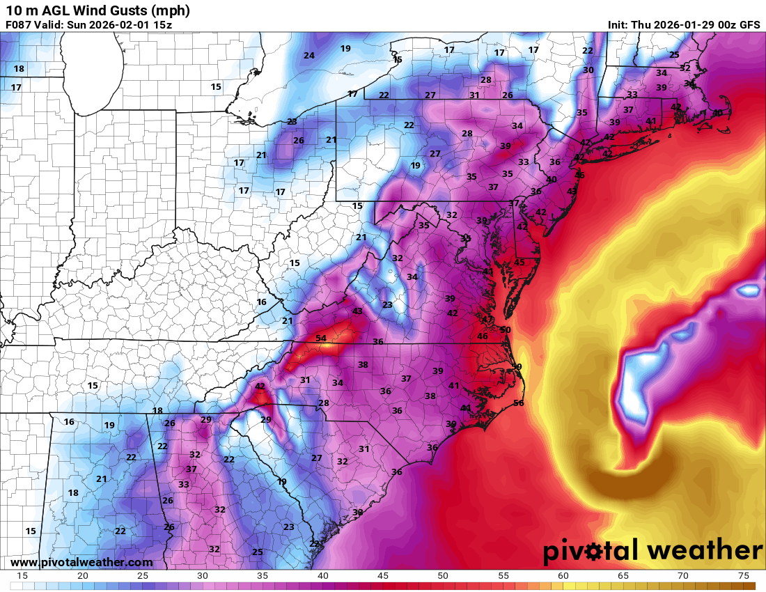
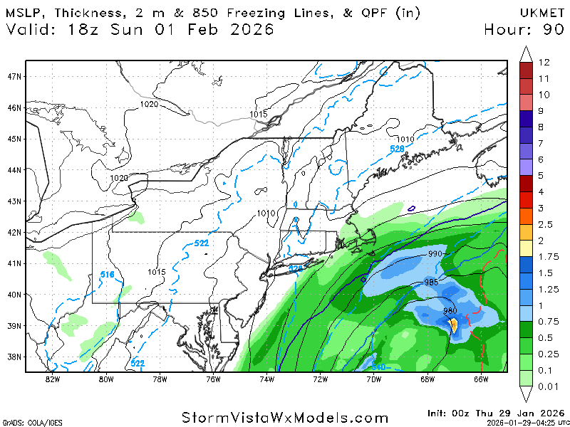
Possible coastal storm centered on Feb 1 2026.
Wxbear25 replied to Typhoon Tip's topic in New England
im wondering how much of that is being skewed by a couple of rogue members. With that being said, ~10% chance of 24 hr QPF >1.00" over LI on the 00z run, as opposed to 0 on the 18z, so theres that -
February 2026 Medium/ Long Range Discussion: Buckle Up!
Nomz replied to Weather Will's topic in Mid Atlantic
Yeah looks off timing but ton of time for that to change. Not gonna stress about it till JMA hits us with 30". -

The “I bring the mojo” Jan 30-Feb 1 potential winter storm
Jimbo! replied to lilj4425's topic in Southeastern States
With those winds could we end up with blizzard? I mean they did want to reschedule for Monday or Wednesday next week lol . -
OK these caught my attention. If you've never read this New Yorker piece about that quake (and the risk of another one), it's one of the best pieces of non-fiction magazine writing science you will ever read. It won a Pulitzer prize.: https://www.newyorker.com/magazine/2015/07/20/the-really-big-one My first job out of college was working as a Guide at Monticello. I always managed to slip in Jefferson's weather diary and in the winter talked about this storm and the Christmas 1776 storm (he was at Monticello for it while Washington was crossing the Delaware).
-
GEFS mean is a good 4" in upstate GA
-

February 2026 Medium/ Long Range Discussion: Buckle Up!
Bob Chill replied to Weather Will's topic in Mid Atlantic
Shortwave is across guidance and it has a gulf/baja connection but it's not impressive for now. Run of the mill but has trended towards a better pass underneath us. Cmc has it and h5 looks half decent
-

Winter 2025-26 Medium/Long Range Discussion
TheClimateChanger replied to michsnowfreak's topic in Lakes/Ohio Valley
What an incredible winter so far. It may be a LONG time before we see another winter off to such a fast start. I was looking at some numbers... Columbus and Dayton, Ohio have both registered more snow through today's date than every other winter since 1996, except for 2014. And at Dayton, only two winters since 1978 have seen more snowfall through today's date (1996 & 2014)! Not as impressive, but still noteworthy, Cleveland and Detroit have recorded more snowfall through today's date than every winter since 2006, with the exception of 2009 & 2014.