All Activity
- Past hour
-
Been a dry, and seasonable Aug so far up my way (favoring the + side). Chance at precip in the next couple days. Early Fall wx starting to creep in next week. Much better than sticky, but this week has been pretty good with cooler mornings.
-
 Some big clouds to my north blocking all the sun for them... Luckyyyy
 -
If the ridge ends up more defined than current guidance vision creating a weakness to draw it N ... a weaker formed Erin could then get left behind - it's lower probability for the time being, but not impossible.
-
Out in Canaan Valley this week Perseid hunting. Haven't seen any Perseid's this year but some absolutely fantastic storms came through last night beginning around 1AM. Very electrical w/ pouring rain, little to no wind. Perfect for enjoying on the porch! Looking forward to more later today.
-

Tropical Storm Erin - 45 mph - W @ 20
olafminesaw replied to BarryStantonGBP's topic in Tropical Headquarters
I knew climo favored a recurve, but my goodness...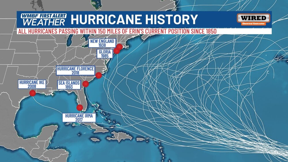
-
So doesn't Miami...what is the value of that perfunctory assessment? The volume disparity makes it silly to compare. When you put things into respective regarding how anomalous the prior decade was in the opposite direction, the current drought is still largely regression attibutable. I know my 10 year average just slipped blow normal this past year....but frustrating, nonetheless.
-

Tropical Storm Erin - 45 mph - W @ 20
40/70 Benchmark replied to BarryStantonGBP's topic in Tropical Headquarters
In fairness, that isn't too rare in major nor' easters. It wasn't a huge deal. -
Probably grabbing the strong thermals.
-
Not sure what style you're looking for but Barking Crab is good for "in-the-rough" shellfish, etc. Went there years ago and enjoyed it. Plenty of choices obviously and don't pass up Chinatown.
-
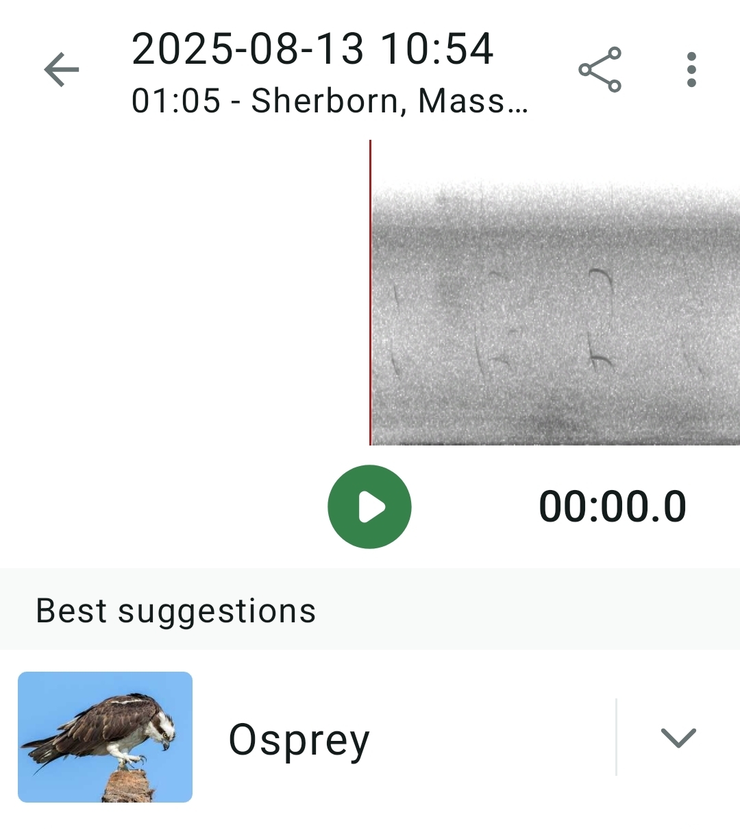
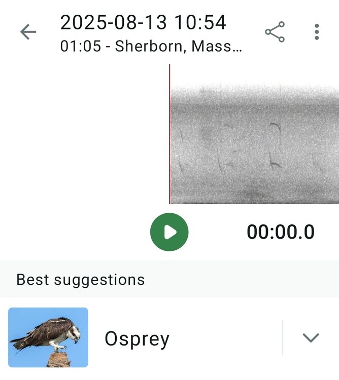
Here's a cool one (at least to me). Never seen an osprey around here in my life. Very familiar cry in the treetops but wasn't sure what it was. I guess mid-August is when they migrate. Gone in less than a minute. Merlin:
-
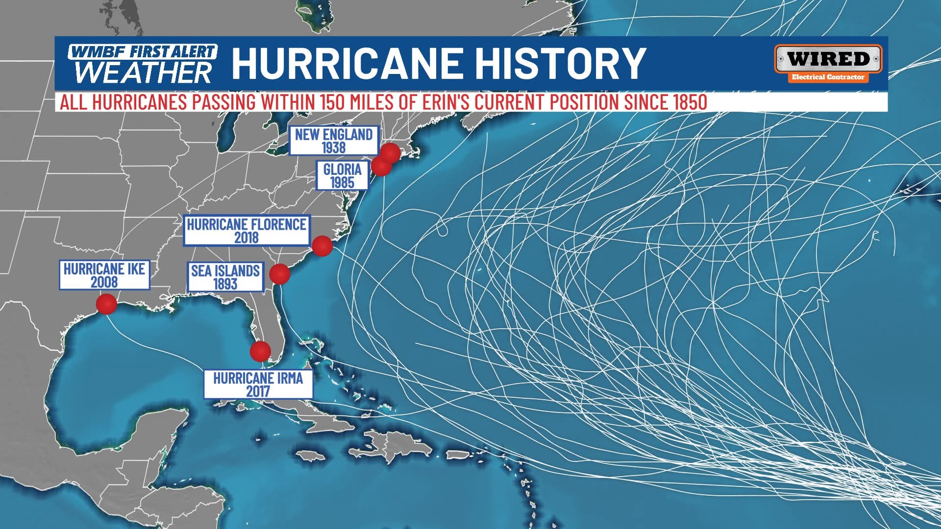
Great post^ I'm just gonna put this one here, because that mean track is being pretty well followed per the latest NHC cone.... We watch.
-
87 degrees with a strong breeze out of the south. It kinda helps cool you down even if just sitting in the shade. Going to be a quick coffee while outside watching dog.
-
 Dews are popping 87/78/99
 -

Mid to long range discussion- 2025
WinstonSalemArlington replied to wncsnow's topic in Southeastern States
The end of next week looks nice -

New England 2025 Warm Season Banter
TheClimateChanger replied to bristolri_wx's topic in New England
Saw NWS Portland reached 100F too, but that was the one in Oregon, not the office in Gray. -
If you go to their channel I think this is the only map they have and just yearly repost lol.
-
New track at 11am shifted SW a bit which just matters for Bahamas and anyone vacationing around there (following closely for 2 groups of friends I have going on cruises this weekend to Bahamas and Bermuda). Erin is forecast to intensify into a hurricane tomorrow night or Friday with a period of rapid intensification possible.
-
How much do you want to bet this dies as soon as it hits the 95 corridor?
-

Tropical Storm Erin - 45 mph - W @ 20
NorthHillsWx replied to BarryStantonGBP's topic in Tropical Headquarters
Let’s just add the entire western basin into the cone… -

Tropical Storm Erin - 45 mph - W @ 20
Torch Tiger replied to BarryStantonGBP's topic in Tropical Headquarters
In fairness, it was a pretty good hit for ACK. 90mph gust iirc -
I still think this very well could track west of Bermuda, especially given Erin is remaining weaker and continuing to track on the southern envelope on guidance which feasibly means tracking farther west prior to re-curving. But the end game is still going to re-curve and still far enough away from the EC for the only impact to be high surf. Maybe Cape Hatteras gets scrapped with cirrus. But all summer, we have seen some impressive shortwaves tracking across eastern Canada and getting across southeastern Canada at times. The ridge may be stronger, but if anything its stronger in the poleward direction versus being more of a E-W expansive high. There are a series of shortwaves which will be diving through over the next week which will continue impacting the WAR and allowing for weaknesses. Maybe this gets to 75W but even if so, the end game will be a sharp recurve.
-
New England 2025 Warm Season Banter
TheClimateChanger replied to bristolri_wx's topic in New England
Made it up to 100F at Dixfield, Maine yesterday (reported as today's high due to morning observation time). Several other locations in the State reached 99F. While falling well shy of the monthly state record of 104F, that was the 1st 100F high temperature observed in the State of Maine in the month of August since August 15, 2001, when it reached 101F at Livermore Falls 1 E. I believe that was also a morning observation, as the prior day had a high of 100F at Fryeburg, Maine. In fact, since the record heat wave of 1975, only one other date besides yesterday & the date(s) in 2002... on August 9, 2001, Fryeburg reached 100F. -
REALLY dry air, is also REALLY dense air...And that's also observed in a data sparse region so we might want to take the over on how strong that ridge is... Better bet due to both influences--weaker TC, and stronger high--you want to hedge strongly in favor of a track further west and south at least to the bahamas...
-
 6z EURO AI brings the hurricane decently close:
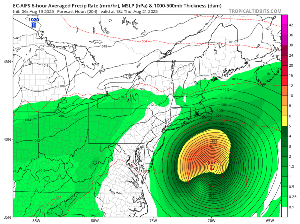
-
Seeing the NAO is shifting from postive to deeply negative over the next 7 days. Looks like trending towards an east-based -NAO... That will shake the forecast track up for sure...