All Activity
- Past hour
-
OK we got some make up rain this morning with that back-building band that sat over central MD. Winding down now after adding 0.8 for about 1.1 total since Saturday
-
Got into steady light rain in Baltimore city for the last few hours. Hopefully places north of downtown are getting in on this too...
-
more 90 degree days but less 95+ and no 100+?
-
Nah he’s headed to ALB or Troy as usual to get his filet o’ fish from his favorite McD’s.
-
it's the best way to neutralize the bad weather outside, it feels like summer in my house
-
Yes, it neutralizes the horrible weather outside. it actually feels sunny inside my house
-
did we have a la nina state in the 44-55 period too?
-
why cant we get that here?
-
We were at Saturdays game, turned out a perfect day. And we were treated to a great ball game. I don't drink much any more, but beers taste pretty good at baseball games
-

2025-2026 ENSO
PhiEaglesfan712 replied to 40/70 Benchmark's topic in Weather Forecasting and Discussion
Wasn't this the one that produced the 120F (50C) temperatures in Western Canada at 50N latitude? -
i need it to be like under 68 or i will not sleep at all, i could not imagine 80 degrees inside
-
WOW, you like it very warm. Most people like room temperature in the low 70s. Like most people, I'd never be able to sleep if it was in the 80s in my house. 70 to 72 is my perfect temp range for sleeping.
-
Pitt County had almost 9" in places and widespread 5-8" totals, many roads underwater this morning and even some washed out....most of it fell in 5-6 hrs. Dozens of water rescues last night as roads flooded and trapped people. This has led to widespread flooding across portions of Greene, Pitt, and Martin Counties, with MRMS maximum ARIs of 70-90 years. In other words, there is roughly a 1% chance of an event like this occurring in any given year, making it a notable flash flood event. What`s more notable is that last night`s event was not associated with any tropical system.
-
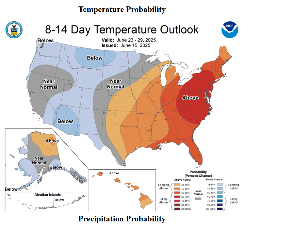
CPC likes the period
-
Steady rain again up to 2.77" for the event Saturday - today
-
Newark, NJ Jul - Aug 1988 July 29 95 73 0.00 0.0 July 30 99 78 0.00 0.0 July 31 90 76 0.00 0.0 Day High (°F) Low (°F) Precip. (inches) Snow (inches) August 1 91 76 0.00 0.0 August 2 94 76 0.00 0.0 August 3 93 76 0.00 0.0 August 4 92 77 0.00 0.0 August 5 90 77 0.00 0.0 August 6 90 75 0.00 0.0 August 7 93 77 0.00 0.0 August 8 90 75 0.00 0.0 August 9 92 75 0.00 0.0 August 10 93 76 0.01 0.0 August 11 97 77 0.00 0.0 August 12 95 80 0.00 0.0 August 13 98 79 0.00 0.0 August 14 98 80 0.00 0.0 August 15 99 81 0.00 0.0 August 16 92 74 0.00 0.0 August 17 90 70 0.05 0.0
- Today
-
Nice rain for HoCo west of 29 this morning but mostly scraps for MBY.
-
Wiz is headed to SE VT on Thursday afternoon on the 12z NAM
-
Only 8 days due to the excessive tree growth over the sensors.
-
it's wild that the rainiest day of the entire month had a high of 99. It would have been over 100 if not for that rain lol.
-
Looks like EWR also had an 8 day streak of 95+, was that their longest? Maybe not, as July 1993 was hotter there, 5 consecutive days of 100+
-
wild, 4 100+ days in just the first 13 days of the month lol By the way, it looks like it's going to be cloudy on Wednesday and more rain on Thursday? Looks like we won't see sunny weather until Friday? In a way it's a good thing as it will reset the pattern back to sunny weekends.
-
Newark, NJ August 1944 Day High (°F) Low (°F) Precip. (inches) Snow (inches) August 1 93 70 0.00 0.0 August 2 79 70 0.46 0.0 August 3 82 70 0.23 0.0 August 4 100 68 0.00 0.0 August 5 102 75 0.03 0.0 August 6 87 71 0.53 0.0 August 7 79 63 0.00 0.0 August 8 84 66 0.00 0.0 August 9 86 58 0.00 0.0 August 10 97 60 0.00 0.0 August 11 102 67 0.00 0.0 August 12 98 71 0.00 0.0 August 13 100 73 0.00 0.0 August 14 98 75 0.00 0.0 August 15 99 73 0.00 0.0 August 16 99 68 0.86 0.0 August 17 95 73 0.00 0.0 August 18 83 65 0.17 0.0 August 19 78 60 0.00 0.0 August 20 82 56 0.00 0.0 August 21 88 58 0.00 0.0 August 22 85 67 0.01 0.0 August 23 89 64 0.00 0.0 August 24 77 57 0.00 0.0 August 25 77 55 0.00 0.0 August 26 77 53 0.00 0.0 August 27 76 54 0.00 0.0 August 28 78 53 0.00 0.0 August 29 78 62 0.00 0.0 August 30 86 58 0.00 0.0 August 31 90 62 0.00 0.0
-
Misty and dreary here.
-
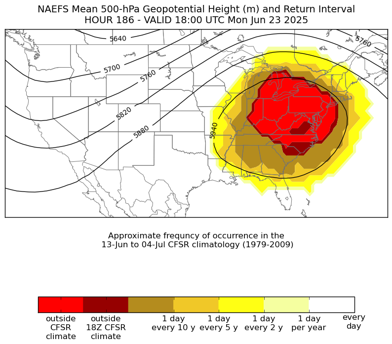
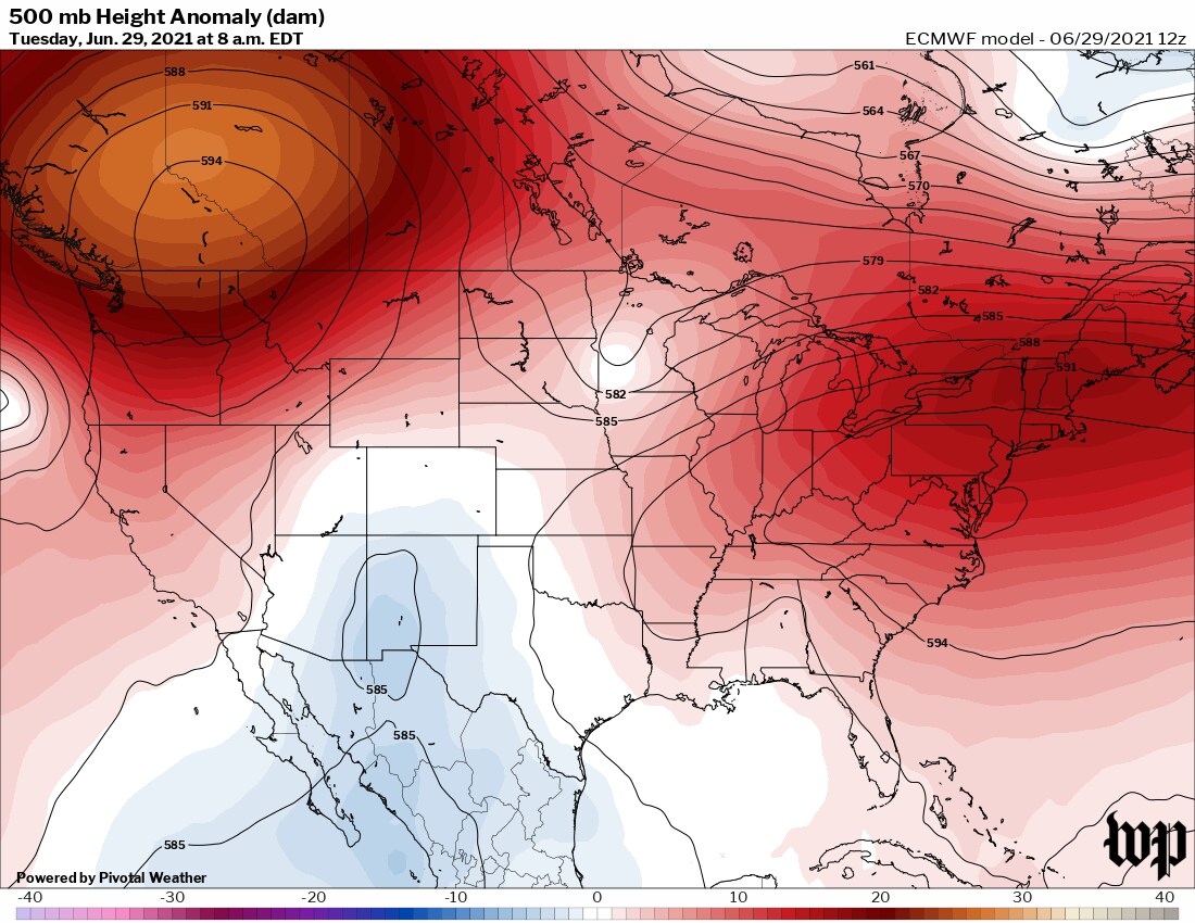
The La Nina background pattern will be in full effect next week. One of the strongest Southeast Ridges on record for late June in the forecast. Could even rival the ridge and heat experienced in late June 2021. I would take a repeat of January 2022 in a second if we can get the Pacific Jet to back off a bit in coming seasons. But the current WPAC warm pool is still running near record levels.