All Activity
- Past hour
-

November 2025 general discussions and probable topic derailings ...
dendrite replied to Typhoon Tip's topic in New England
The 200mb VP anomalies? -
For what it’s worth, the Euro AI has performed really well of late, including sniffing out the brief Thanksgiving cold shot followed by warmth, and it has below average temps up and down the EC by around the 5th. Goes to show it’s not all bad on the models but I still think sustained cold isn’t coming until we work into the mid month (maybe the 10th if we’re fortunate) timeframe. The teleconnections just aren’t there but phase 8 should be coming in to play by that juncture.
-
November 2025 general discussions and probable topic derailings ...
dendrite replied to Typhoon Tip's topic in New England
We were out in Gilford all afternoon and I said the same thing. Def a pre-snow event vibe to the clouds. -
The winter is actively showing it's hand with that torch being forecasted first week of December. As many have posted about here, if you're on the east coast, warm Decembers in a nina are about the worst signal possible.
-

2025-2026 ENSO
michsnowfreak replied to 40/70 Benchmark's topic in Weather Forecasting and Discussion
This map is a great one to show why snowlovers in the Great Lakes always prefer nina over nina.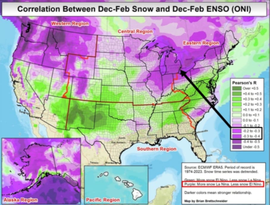
-

MO/KS/AR/OK 2025-2026 Winter Discussion
NWAflizzard replied to stormdragonwx's topic in Central/Western States
12z euro really brings the cold later in this run . Dropping it out west and slowly moving it into our area along with some snow. Still battling that ridge in the east. -
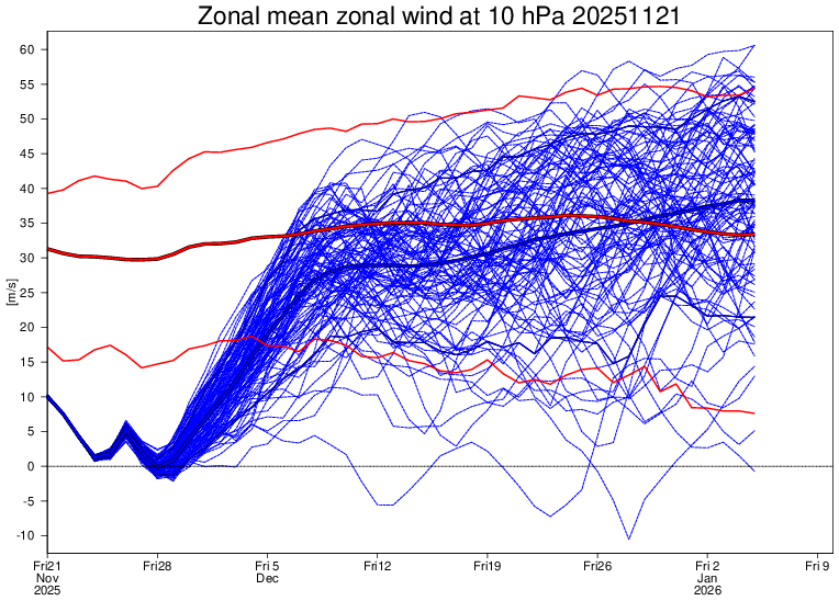
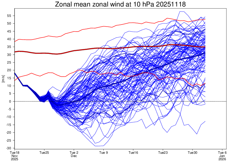
Today’s Euro Weeklies update on the SPV compared to last run keeps the reversal (or near reversal) but it’s a fair bit stronger Dec-early Jan. Keep in mind that the prior two runs were already significantly stronger for that period: Today’s EW mean zonal wind at 10 mb (11/21): significantly stronger than 11/18 run with, for example, 12/12 at +29 vs +11 on 11/18 run: EW run from just 3 days ago (11/18): 12/12 had been at only +11
-

November 2025 general discussions and probable topic derailings ...
weatherwiz replied to Typhoon Tip's topic in New England
There are times when we can have a very solid idea looking 2-3-4 weeks out but I don't think this is one of those. There is just way too much going on and too many complexities, especially in the short term on how some of the subtle features evolve. Part of it too is we are still in the seasonal transition across the hemisphere and often times that can enhance the battles within the models. But I just want to get a favorable pattern moving through December and have cold air available. The brunt of the cold doesn't need to be over us and the cold doesn't necessarily need to be locked in. If we get a favorable storm track with cold air nearby...we will cash in (maybe not so much for coastal areas early on). Having cold air in place or even nearby means nothing if the storm track sucks. -
I lived in the Jersey Highlands 1950 to 1971, and never saw anywhere near that many oak leaves in the latter half of November. Oaks and Maples were the most common of the many tree species in the forests near home, mid-aged as most land there had been grazed into the late 1800s. Oaks I remember (long before forestry school so some guesswork) were Northern red, black, pin, white, swamp white and where glaciers had scraped the hilltops, chestnut oak. I'm confident that several other oak species were also in the mix.
-
2025-2026 ENSO
michsnowfreak replied to 40/70 Benchmark's topic in Weather Forecasting and Discussion
Agree to the bolded 100% -

November 2025 general discussions and probable topic derailings ...
WinterWolf replied to Typhoon Tip's topic in New England
It Pretty much comes down to…we just don’t/won’t KNOW…until very close in. What we do know, is there looks to be potential. But will it be realized? -
November 2025 general discussions and probable topic derailings ...
weatherwiz replied to Typhoon Tip's topic in New England
Been thinking that all day, its had that look -
 Boy does it look like it wants to snow
 -

Fall 2025 Medium/Long Range Discussion
OrdIowPitMsp replied to Chicago Storm's topic in Lakes/Ohio Valley
Worrying that there is only a slight risk over the Rockies. Snowpack in Colorado is near record low for this time of year. -

November 2025 general discussions and probable topic derailings ...
CoastalWx replied to Typhoon Tip's topic in New England
On both of those ensembles, the EPS and the AIEPS, I see a ridge off the West Coast and part of a trough dipping into the southwest corner of the US. I don’t really see any red flags? If anything that trough over the southwest will help shoot some impulses northeast because otherwise if we didn’t have that, I think we might have suppression working its way down. -
November 2025 general discussions and probable topic derailings ...
weatherwiz replied to Typhoon Tip's topic in New England
yup...that could easily be overstated too. -
November 2025 general discussions and probable topic derailings ...
weatherwiz replied to Typhoon Tip's topic in New England
A big problem is even when we seem to get good PAC setups we can't seem to get a favorable orientation of the ridge so what looks to be a +PNA I don't think is a true +PNA and with the orientation of the ridging it just results in a dump of cold and a trough into the West and the result in pumping the heights up out east...big problem to have, especially when the SE ridge is still a prominent player. We would either need to get some blocking to flatten it a big or hope for an active northern stream and keep dampening the ridge a bit. But let's see what happens across eastern Russia and Asia over the week. Right now you have the PV on that side of the hemisphere and you have lobes breaking off it and ejecting across the NPAC within the East Asian jet stream. Late this weekend the Euro breaks off a piece and it looks like this piece is slated to be a big player in how the pattern evolves By Thursday you have a major ridge bridge to the north with the energy significantly stronger and forced to remain south with a lead wave ahead of it This really helps to pump up a ridge downstream and helps aid in the amplification of that lead shortwave across the Northwest and a subsequent significant increase in the heights out in the East. My point in all this is just too illustrate how fickle guidance be be in the evolution of a pattern just from one piece. If such a piece never breaks off or is not as strong as advertised...that completely changes the game. The northern hemispheric flow is way too chaotic right now...its like a nascar track with too many drivers...so many drivers trying to set their lane and pace the field but everyone is competing to do the same thing. This makes it nearly impossible to have any idea of what to expect, until you start to see how these players in the 48-72 hour forecast actually look at 48-72 hours.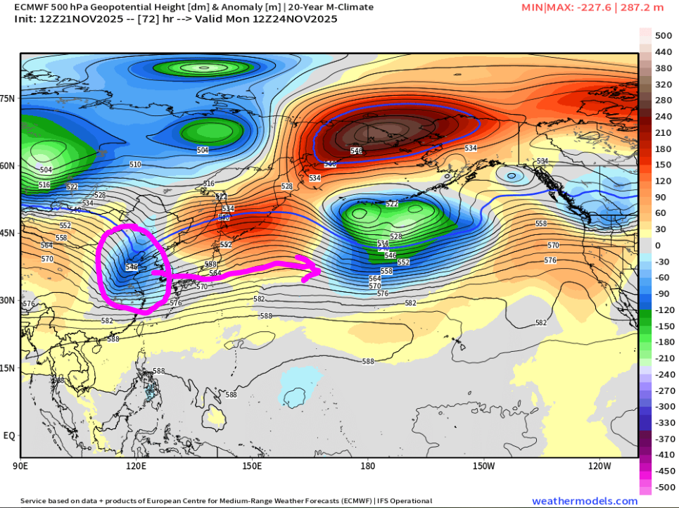
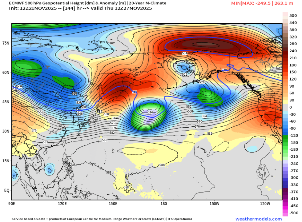
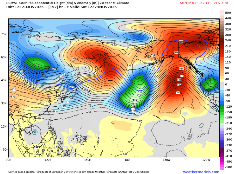
-
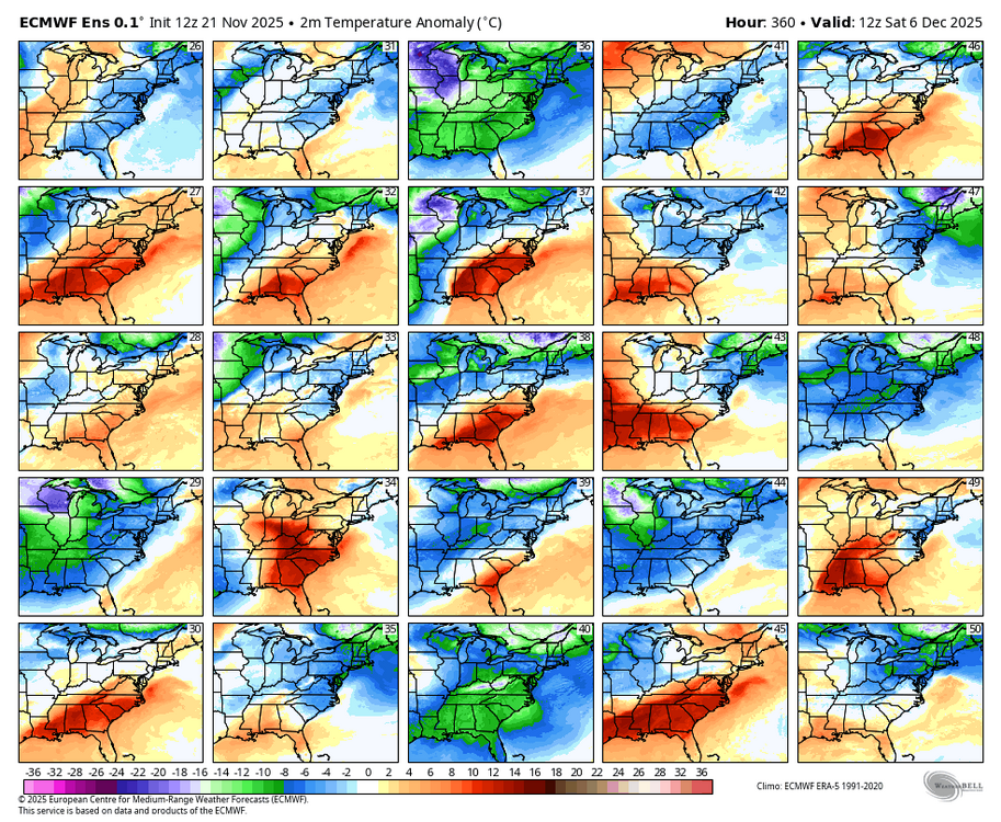
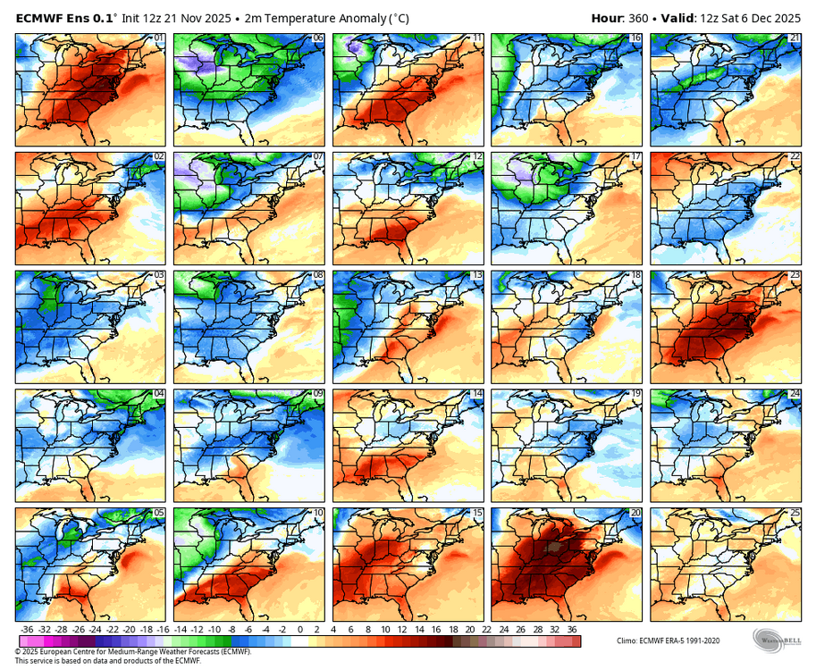
When you go out to Dec. 6, you see that that the model is really struggling with the pattern. Some members torch; some members cold. So we are in wait mode....WB 12Z EPS
-
let it torch in early-december, IDC too much. just let it be cold mid-late december
-
Correct. Looks like a chilly Thanksgiving weekend with warmth on either side.
-

November 2025 general discussions and probable topic derailings ...
eduggs replied to Typhoon Tip's topic in New England
I think I'm looking for the same things you're looking for. I only commented on your posts for clarification because I'm not seeing what you're seeing. -

November 2025 general discussions and probable topic derailings ...
SnowGoose69 replied to Typhoon Tip's topic in New England
It’s why I’m not sold on the massive SER in early Dec. the problem last winter and when in recent weeks when ensembles tried showing that was it was solely based on some type of huge cutter developing and pumping the ridge. But in fast flow even those have a hard time developing -
November 2025 general discussions and probable topic derailings ...
CoastalWx replied to Typhoon Tip's topic in New England
The ensembles show our source region in Southeast Canada cold. We haven’t seen anything like that in years. I’m not looking for a KU pattern just something that often chances and I think this one will. -
Am I missing something, or do the 12z Euro/ENS and GEFS just dump all the cold air out west and just torch the east coast.
-
November 2025 general discussions and probable topic derailings ...
CoastalWx replied to Typhoon Tip's topic in New England
None of those models had a trough coming in and a massive SE ridge. On the means anyways. I’m not losing sleep over op runs.


