All Activity
- Past hour
-
snow melt season is getting later and later in the arctic... might be late september until ice loss is at a end..
-
 i remember in the 1980's when a cold front came through temp fell into the 50's one afternoon in nyc in september that would be impossible today..
 -
Oh, ha... well, in that case - any given location could get lucky with a training axis. This does look a bit like it could be a slow evolving scenario so convection might orient into favored bands, along which there can be decent totals. In between? not so much.
-
 It's 80/52 and sunny here. I took my jacket since it was so brisk.
 -

2025 Lawns & Gardens Thread. Making Lawns Great Again
dryslot replied to Damage In Tolland's topic in New England
It is a small young tree 2', It still has some cambium attached, I used some grafting tape and are supporting it with a dowel, I hate to cut it off as its the top of the tree, But if it doesn't take i will have to prune it off, I'm finishing up a small greenhouse to winter them in as i have no room in the house and don't need my cats eating the leaves although those thorns are quite painful as i found out.................... -
Another chilly a.m. with Duluth 40 (t3rd), Hibbing 36 (4th), I-Falls 39 (t6th). Significantly cool air mass for this time of year to be sure. Scattered shwrs/stms cast for tomorrow, so hope to get under some of that. Other than that, pretty seasonable wx overall to end the month after the front blows thru as avg temps start their Fall slide. Upper 60's-low 70's with upper 40's-low 50's. Inland areas may get a little cooler with radiational cooling. A very nice Labor Day weekend on tap. Looks like my Holiday forecast will be pretty good.
-
 It’s not cool today lol
 -

2025 Lawns & Gardens Thread. Making Lawns Great Again
dendrite replied to Damage In Tolland's topic in New England
How large is the branch? Was it a complete break or is some cambium still attached? On bigger splits some people drill through each side and kinda clamp it together. Or you could use a couple ratchet straps and get it tight. If it’s a small tree, nevermind. lol -
Could certainly be some upslope enhancement up in NNE. Also wouldn't rule out the potential for a tornado or two within the valley.
-
I inspect our dams over here in Montgomery County. Generally, this region take good care of the water infrastructure.
-
Nammy actually slows the front a bit over the region as the ULL starts to stall north of ART.
-
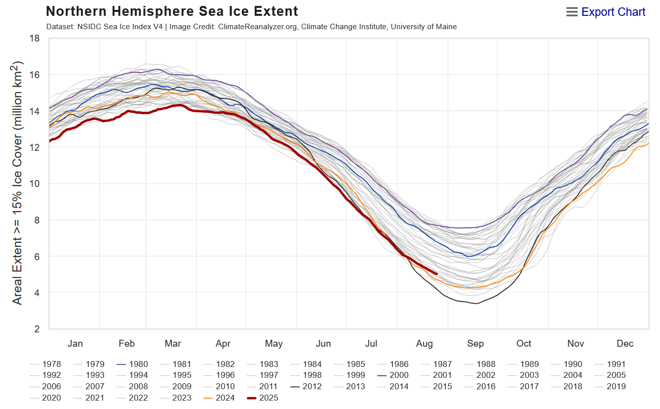
Interesting shallowing of the ice loss ...relative to recency that is. Good sign for winter enthusiasts? - well, at least analytically for me I've come to find in the past that the rates of d(ice) and d(land-snow) in autumns appeared to be positively correlated to N/A mid latitude winters during ensuing cold season. We've still got about 2 weeks to go before climo bottoms out and we enter autumn so we'll see if this year can be another test for that.

-
Dendy soaker
-
Thanks Tip. i mean, I could really use the rain. Sitting at just over 1/2" here MTD. the summer fronts tend to split not long before they get here, so it is usually not very rainy. glad to hear that this is a frontal passage, not a synoptic rain event.
-
The 12Z Icon, which then has it become a TS, is implying an eventual though not immediate safe recurve from the US would later occur on that run fwiw. Other 12Z runs: -GFS still doesn’t have a TC from the far E MDR AEW. However, it does now have a weak reflection at the sfc as well as upper level vorticity clearly showing up now. So, this is a hint that the GFS may in runs soon start showing this as a closed sfc low. -CMC has nothing unlike prior runs -UKMET, Euro, and JMA still yet to be released
-

2025 Lawns & Gardens Thread. Making Lawns Great Again
SJonesWX replied to Damage In Tolland's topic in New England
-
I wrote farther up how noontime on the September Equinox is the same angle as the June solstice at 4PM. 90s at 4PM on June 21st feel plenty hot haha
- Today
-
First time I’ve seen LWX mention the cloud bias… .NEAR TERM /THROUGH TONIGHT/... Shortwave-trough dropping sewd from Michigan this afternoon will result in bkn clouds this afternoon and isold-sct showers across the mountains. Increased PoPs across the mountains and sky cvr grids as NBM has a notorious low bias for cloud cvr and PoPs in W to NW flow.
-
The mountain cloud factory is cranking a bit. Still a pleasant day, but kinda lol that the forecast here now says turning mostly cloudy this afternoon.
-
 By Setember 10th the sun angle is equal to March 31st..it might get up to 90 but it doesn't feel the same as June to mid August
 -
Friday should actually see some gusty thunderstorms and some hailers...particularly along and north of the Mass Pike. Northeast Mass into southern/eastern NH could be favored.
-

2025 Atlantic Hurricane Season
BarryStantonGBP replied to BarryStantonGBP's topic in Tropical Headquarters
does she recurve or beeline? -
Perfect day to cut some bigguns.
.jpg.0e897277528b94214e5879d16009bb8c.jpg)
.jpg.14df7c394f3f2131fd9604c3f27d0073.jpg)
-

2025-2026 ENSO
winter_warlock replied to 40/70 Benchmark's topic in Weather Forecasting and Discussion
Doesn't matter. I've seen us have a big -NAO and still get absolutely nothing out of it. And I've seen us have a +NAO and us get snowstorms out of it. I think the NAO doesn't matter as much as it's hyped.. in my opinion -
45.7 degrees at 6:45!! That would be normal at Staunton on October 10.