All Activity
- Past hour
-
The Southern Delta Aquariids meteor shower peaks Tuesday night into Wednesday morning next week. Hopefully we'll have good sky conditions. The moon won't be too much of an issue, so it should be a decent shower. You can see up to 15 to 20 per hour with good conditions. You can catch the early part of the famous Perseids meteor shower now too. The peak of that shower where you see a much larger amount of meteors (50 to 100 per hour) is August 12th to 13th, but unfortunately the mostly full moon is going to be a major issue. So the Perseids won't be as spectacular this year. Probably a good idea to try to catch the smaller amount of Perseids along with the Delta Aquariids next week before the moon becomes an issue in August. The best meteor shower this year is expected to be the Geminids in December.
-

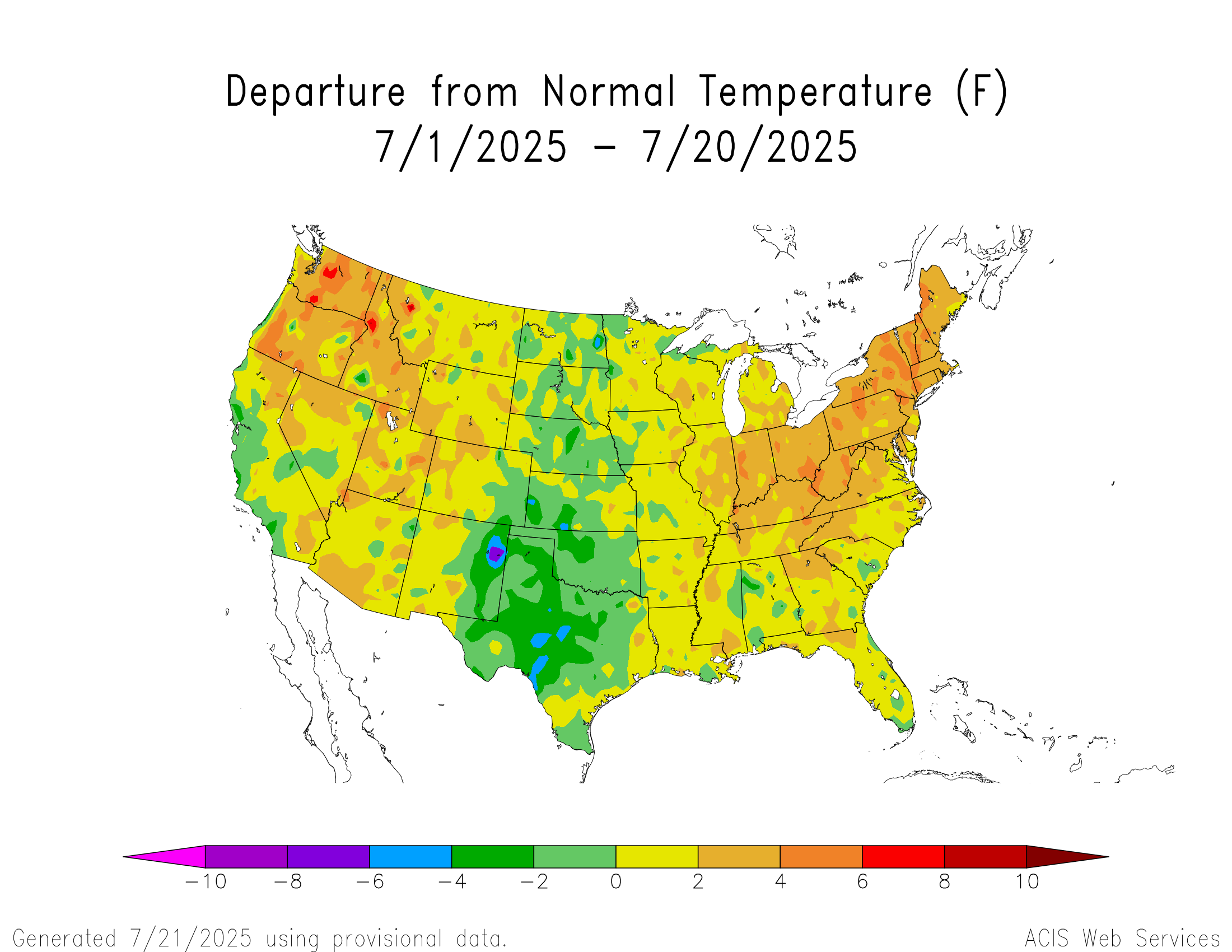
July 2025 Obs/Disco ... possible historic month for heat
forkyfork replied to Typhoon Tip's topic in New England
we had a chance in june but we got a weird flash flood blob instead of a derecho -

July 2025 Obs/Disco ... possible historic month for heat
weatherwiz replied to Typhoon Tip's topic in New England
yup...this is what summer used to feel like in the 90's after our FROPAs...when we used to also get nasty squall line blowing across the region. -
July 2025 Obs/Disco ... possible historic month for heat
weatherwiz replied to Typhoon Tip's topic in New England
It will suck if we can't get one legit (like EML potential) severe weather threat in the upcoming pattern. The important details will be Where ridge axis is centered and how expansive (latitudinal) the ridge is - this will be important in terms of the strength of the mlvl flow and where that axis traverses along with strength of shortwave energy traversing the flow. We would want to see the pattern favor shortwave amplification over the Northeast. Where any plumes of EML air eject and whether they can maintain their integrity which will be dependent on convection and how overturned the airmass would get over the northern Plains and upper-Midwest. The synoptic look is something that could favor EML advection into our region, however, any EML advection could also easily get shunted to our southwest. -
July 2025 Obs/Disco ... possible historic month for heat
forkyfork replied to Typhoon Tip's topic in New England
it doesn't feel like fall it feels like a summer from the past -
79/65. off to the garden center to buy some shrubbery.
-

July 2025 Obs/Disco ... possible historic month for heat
metagraphica replied to Typhoon Tip's topic in New England
79/60 almost perfect except a slight haze coloring the blue sky. -
I posted this in the Discobs thread, but it really belongs here. Ensemble guidance is still advertising a shift in the longwave pattern with the upper ridge retrograding into the central/western US for the end of the month into August. That should at least give us some drier air if not notably less hot. That pattern could also put our area in a position for impacts from mesoscale convective systems that develop on the periphery of the ridge and drop southeastward.
-

July 2025 Obs/Disco ... possible historic month for heat
dryslot replied to Typhoon Tip's topic in New England
67/46°F, Very fall like outside today. -

July 2025 Obs/Disco ... possible historic month for heat
NoCORH4L replied to Typhoon Tip's topic in New England
First shot across the bow for real? -
It was like that here too, but sun broke out in the last 30 mins. Still pretty humid but not awful. 80/66 Dews should lower through the afternoon with a breeze out of the north. This evening should feel fantastic. Tomorrow is going to be about the best weather we get in this area in late July, and Wed should also be very nice.
-

July 2025 Obs/Disco ... possible historic month for heat
Damage In Tolland replied to Typhoon Tip's topic in New England
Graham is headed up there for the weekend in VT. So you’ll be around in CT for beers! -

July 2025 Obs/Disco ... possible historic month for heat
Lava Rock replied to Typhoon Tip's topic in New England
68/54. Almost fall-like with the breeze. -

July 2025 Obs/Disco ... possible historic month for heat
powderfreak replied to Typhoon Tip's topic in New England
Yeah, looks like a warm weekend. I'll be down in Woodstock later this week and the weekend to breath it all in. -
July 2025 Obs/Disco ... possible historic month for heat
dryslot replied to Typhoon Tip's topic in New England
Going to be a chilly overnight for the radiators tonight. -

2025-2026 ENSO
michsnowfreak replied to 40/70 Benchmark's topic in Weather Forecasting and Discussion
Dec & Mar were definitely what put the orange/yellow on those maps.
-

July 2025 Obs/Disco ... possible historic month for heat
CoastalWx replied to Typhoon Tip's topic in New England
Up at Loon, definitely a Fall feel. -
So much for mostly sunny; it’s been 100% thick clouds all day so far here.
-

July 2025 Obs/Disco ... possible historic month for heat
Great Snow 1717 replied to Typhoon Tip's topic in New England
.....well don't forget that according to one person here, winter begins on 11/1... -

2025-2026 ENSO
so_whats_happening replied to 40/70 Benchmark's topic in Weather Forecasting and Discussion
To be fair it is not perfect but got the idea. Little rough for the mid atlantic/ ohio valley pattern
-
2025-2026 ENSO
michsnowfreak replied to 40/70 Benchmark's topic in Weather Forecasting and Discussion
Just adding to this, I found my paper where I had this data... In 145 years of record, using the POR-average of 41" of snow... There have been 10 winters on record that finished with above avg snowfall WITHOUT a 6"+ storm. The last time this happened was 1996-97. The snowiest of these was 55.1" in 1984-85 (biggest storm 5.5"). The lowest "biggest storm" of these was 1996-97 when the biggest storm was only 4.7" despite 43.1" total snow. There have been 22 winters that did feature a 6"+ storm but still finished with below avg snowfall. The last time this happened was 2006-07. The least snowy of these winters was 20.0" in 1982-83 (biggest storm 7.3") and the highest storm in this dataset was in 1932-33, when despite a 9.0" storm only 25.8" fell all winter. There has never been a winter with a storm over 9" that finished below avg in snowfall. Id be curious to know of all of NYC winters that finished above the longterm avg snowfall, what was the winter with the lowest "biggest storm of the season" where they could still finish above avg in total? -
July 2025 Obs/Disco ... possible historic month for heat
weatherwiz replied to Typhoon Tip's topic in New England
Won't mind sitting outside in October watching Bruins games. Hopefully we roll 80's and 90 right through October. -

July 2025 Obs/Disco ... possible historic month for heat
kdxken replied to Typhoon Tip's topic in New England
Yup
-

July 2025 Obs/Disco ... possible historic month for heat
40/70 Benchmark replied to Typhoon Tip's topic in New England
Probably will be a warm fall.