All Activity
- Past hour
-
29 was the low here.
-
From 34.2 ?? Freeze and frost free at 1K on the hilltop
-
Ugh! Here we go again …..
-

2026-2027 Record-breaking El Nino
jaxjagman replied to Stormchaserchuck1's topic in Weather Forecasting and Discussion
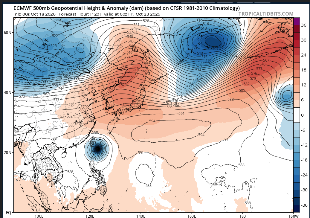
Do agree,you might alrady be seeing this in the extened period,but right now a phoon going into East Asia is going to cause a Upper Level Ridge to build into the Sea of Japan,then days after into the plains and NE,Emembles show this very well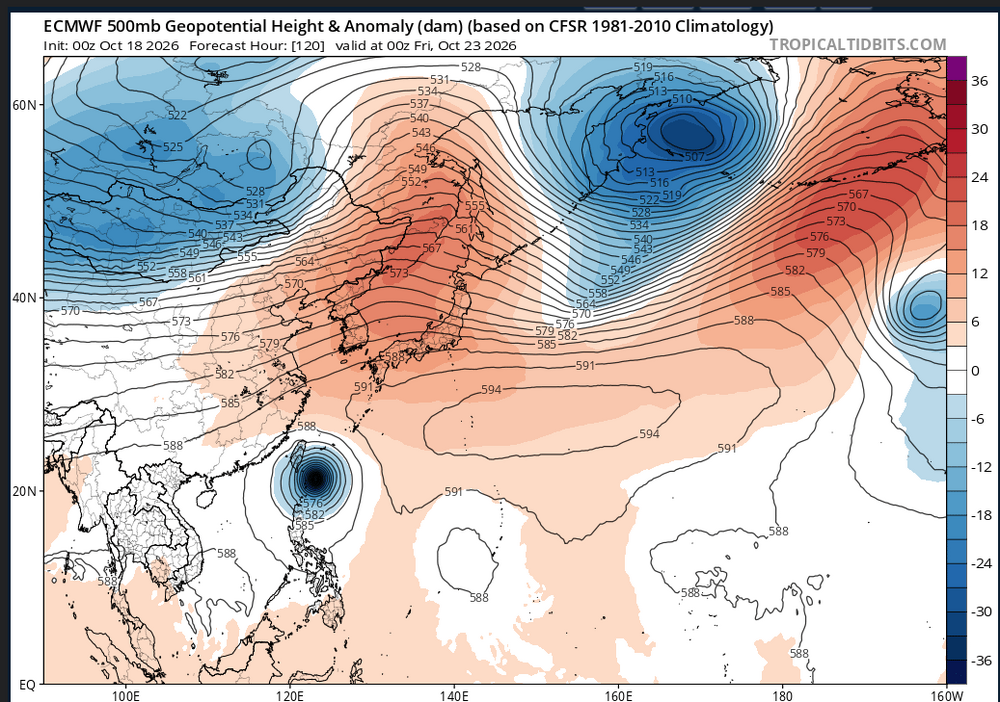
-
Got the penalty and browns got the points
-

2026-2027 Record-breaking El Nino
qg_omega replied to Stormchaserchuck1's topic in Weather Forecasting and Discussion
Your area will see the warmest anomalies in the nation -
2026-2027 Record-breaking El Nino
qg_omega replied to Stormchaserchuck1's topic in Weather Forecasting and Discussion
December looks like historic warmth, +10 to +15 -
No damage from last night?
-
This feels like 527 ravens games I’ve seen before. Totally dominate in so many ways, but keep screwing up just enough to keep an inferior opponent in the game.
-
Loop keeps missing kicks he should be making. Also, that was a pretty terrible PI call.
-
We grow and bloom and GWLH https://imgur.com/a/yaDsc3o
-
Ugh. Not sure 10 is enough here boys…
-

2026-2027 Record-breaking El Nino
mitchnick replied to Stormchaserchuck1's topic in Weather Forecasting and Discussion
How warm and storm tracks are all that matter to me since it'sall about snowfallfor me. In fact, BN temps imby do not guarantee snow with last year being a perfect example. I'm more than willing to roll the dice with any kind of Niño. -
Bottomed out at 30.9 degrees this am, first freeze of the year.
-

2026-2027 Record-breaking El Nino
LakePaste25 replied to Stormchaserchuck1's topic in Weather Forecasting and Discussion
Pac jet will likely move equatorward sometime in mid to late November. If this were a Modoki or neutral we would be gearing up for the classic +TNH/-EPO/+PNA and a cold pattern in the east, but since it’s a super nino it will extend into Cali and that’s way too far east for us. -
Good.
- Today
-
2026-2027 Record-breaking El Nino
jaxjagman replied to Stormchaserchuck1's topic in Weather Forecasting and Discussion
Reckon its good news only being Oct,but you really hate to see Phoons going to East China,and not recurving,never works out very well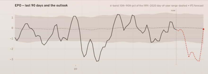
-
Plus frost advisories for west of the immediate DC/Baltimore beltways and southern Potomac River. National Weather Service Baltimore MD/Washington DC 150 PM EDT Sun Oct 18 2026 MDZ006-503>507-VAZ038>040-050-053-506-526-527-190200- /O.NEW.KLWX.FR.Y.0010.261019T0500Z-261019T1300Z/ Northern Baltimore-Northwest Montgomery-Central and Southeast Montgomery-Northwest Howard-Central and Southeast Howard- Northwest Harford-Greene-Madison-Rappahannock-Orange-Fairfax- Eastern Loudoun-Northwest Prince William-Central and Southeast Prince William/Manassas/Manassas Park- Including the cities of Clarksville, Bynum, Reston, Poplar Springs, Castleton, Bel Air, Montclair, Madison Run, McLean, Orange, Woolsey, Everona, Countryside, Owings Mills, Haymarket, Glyndon, Dayton, Dale City, Timonium, Burr Hill, Sterling Park, Reisterstown, Twymans Mill, Hickory, Historic Ellicott City, Fairfax Station, Glenwood, Glenelg, Lake Ridge, Dulles International Airport, Rockville, Watersville, Hackleys Crossroads, Manassas, Randallstown, Boyds, Fordsville, Leesburg, Aden, Simpsonville, Woodstock, Gleedsville, Woodbridge, Cockeysville, Oak Grove, Columbia, Burke, Silver Spring, Washington, Bethesda, Chantilly, Independent Hill, Lahore, Gaithersburg, Four Corners, Flint Hill, Glenmont, Five Forks, Madison Mills, Rock Mills, Long Green, Germantown, Nasons, Unionville, Lisbon, Shady Grove, Fallston, Aspen Hill, West Friendship, Langley, and Annandale 150 PM EDT Sun Oct 18 2026 ...FROST ADVISORY IN EFFECT FROM 1 AM TO 9 AM EDT MONDAY... * WHAT...Temperatures as low as 33 will result in frost formation. * WHERE...Portions of central and northern Maryland and central and northern Virginia. * WHEN...From 1 AM to 9 AM EDT Monday. * IMPACTS...Frost could harm sensitive outdoor vegetation. Sensitive outdoor plants may be killed if left uncovered.
-
-
 over the counter sildenafil: SildenRxExpress - order viagra
 -
Freeze warnings back up for some areas just east of the Blue Ridge. National Weather Service Baltimore MD/Washington DC 150 PM EDT Sun Oct 18 2026 MDZ004-005-VAZ051-501-502-505-190200- /O.NEW.KLWX.FZ.W.0008.261019T0500Z-261019T1300Z/ Frederick-Carroll-Culpeper-Northern Fauquier-Southern Fauquier- Western Loudoun- Including the cities of Bethel, Eldersburg, Lucketts, Rapidan, Westminster, Stevensburg, Buckeystown, Gamber, Turnbull, Catalpa, Park Mills, Airlie, Reva, Warrenton, Ballenger Creek, Cardova, Culpeper, Frederick, and Winston 150 PM EDT Sun Oct 18 2026 ...FREEZE WARNING IN EFFECT FROM 1 AM TO 9 AM EDT MONDAY... * WHAT...Sub-freezing temperatures as low as 30 expected. * WHERE...In Maryland, Carroll and Frederick Counties. In Virginia, Culpeper, Fauquier, and Western Loudoun Counties. * WHEN...From 1 AM to 9 AM EDT Monday. * IMPACTS...Frost and freeze conditions could kill crops, other sensitive vegetation and possibly damage unprotected outdoor plumbing. * ADDITIONAL DETAILS...Expect the coldest temperatures in valleys and other low lying areas. (snip)
-
The great Blizz has awakened with the onset of colder weather. Snow maps will probably be coming within the next month. What's your outlook, prediction on this coming winter?
-

2026-2027 Record-breaking El Nino
GaWx replied to Stormchaserchuck1's topic in Weather Forecasting and Discussion
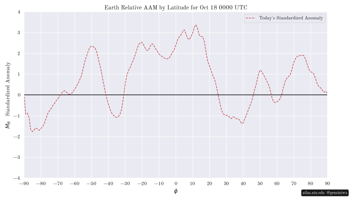
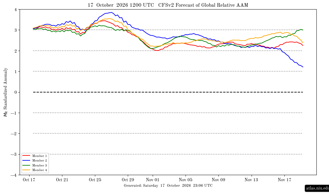
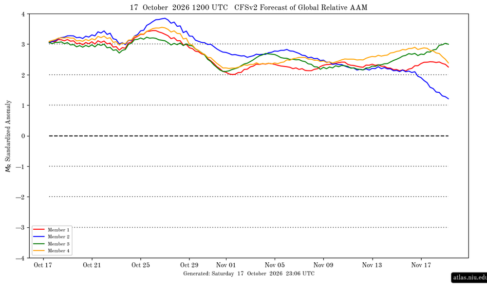
Ray et al, A similar theme to what Ray emphasized last month remains even nearly a month later where the really impressive +AAM emphasis is mainly 30S to 30N: Is it normal during El Nino for the +AAM (atmosphere rotating faster than the solid earth as I understand it), which we know is characterized as El Niñoish, to usually be strongest mainly in the 30S to 30N latitudes (with the highest near the equator) since that is nearer to the Nino regions than latitudes outside of that region? If so, do the regions outside of 30S to 30N normally get consistently positive during strong El Niños? Do they ever consistently average +AAM for long periods or is that typically relegated to 30S to 30N even during the subsequent N hem. winter? ———————— By the way, the relative AAM by lat. above is not surprisingly still supporting a very strong global relative mean +AAM with it back >+3 since Oct 12th: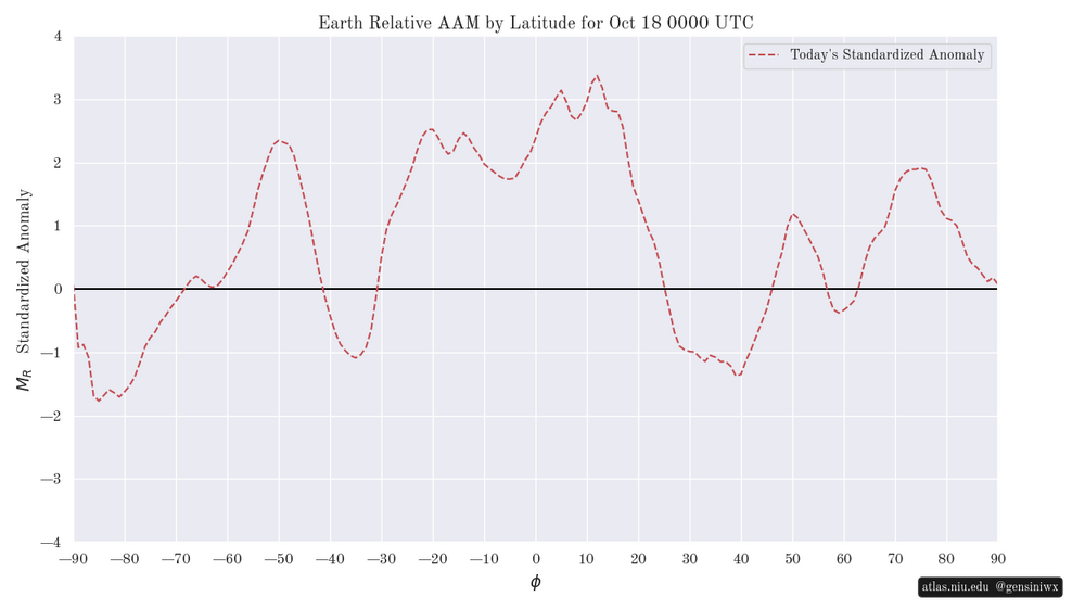
-

2026-2027 Record-breaking El Nino
40/70 Benchmark replied to Stormchaserchuck1's topic in Weather Forecasting and Discussion
We'll see what happens....don't get me wrong, the DJFM period will be warm in the mean...no two ways about that. -
2026-2027 Record-breaking El Nino
jaxjagman replied to Stormchaserchuck1's topic in Weather Forecasting and Discussion
Typhoon going into East China isnt really what you'd like to see.Sea of Japan is already warm,it will probably warm .You have different currents run through East Asia,the Thusima current runs though the Strait of Japan,the Kuroshio current as mentioned above,but just as muxh is the cold polar Oyashio current which runs from the Bearing Sea,this current generally mixes out along the Kurrishio extension,its simply not doing it,its not that cold