All Activity
- Past hour
-

2026-2027 El Nino
40/70 Benchmark replied to Stormchaserchuck1's topic in Weather Forecasting and Discussion
I agree if we approach 2.0, then the PDO will flip. -
2026-2027 El Nino
40/70 Benchmark replied to Stormchaserchuck1's topic in Weather Forecasting and Discussion
We'll see. I'd bet against it, but my early guesses are often wrong because they're just that....guesses. -

2026-2027 El Nino
michsnowfreak replied to Stormchaserchuck1's topic in Weather Forecasting and Discussion
I am NO enso expert, not even close, but I remember a handful of years ago, they were hyping a STRONG (I cant even remember if it was Nino or Nina) event and it failed so bad it was either a cold/warm neutral. Not saying I think this El Nino fails, just that it seems way early to be SO confident in a strong one. -
8 >70 here 71 / 51
-
EWR: 2.8 inches NYC: Trace
-

Central PA Spring 2026 Discussion/Obs Thread
Itstrainingtime replied to Voyager's topic in Upstate New York/Pennsylvania
Happy birthday, little snowmanette! Our youngest will be turning 25 this year. Holy crap. She was actually due to enter the world on 9/11/2001 but the day's events were enough that she came a few days later. Just hard to believe that was 25 years ago. Where does the time go? -
(002).thumb.png.6e3d9d46bca5fe41aab7a74871dd8af8.png) No warming or cooling is my point you miss - just typical cyclical normal climate changes FTW!!
No warming or cooling is my point you miss - just typical cyclical normal climate changes FTW!! -

2026-2027 El Nino
snowman19 replied to Stormchaserchuck1's topic in Weather Forecasting and Discussion
I’m starting to think strong is probably the floor with this event. Modeling has very significant “twin” TC development on both sides of the hemisphere -
Upglide right over that boundary
-

Chester County PA - Analytical Battle of Actual vs. Altered Climate Data
bdgwx replied to ChescoWx's topic in Climate Change
So choosing 2 data points out of a possible 335 to make a trend without any uncertainty analysis is good while taking all 335 with a robust uncertainty analysis is cherry-picking? Make that make sense. And let me preempt your gaslighting. I didn't pick the 335 data point subset or claim that it would be sufficient to draw conclusions about whether the planet was warming or not. You did. -
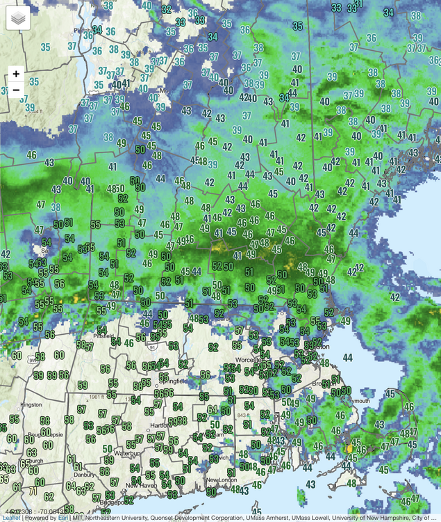
Got 0.30" of rain overnight. A couple stronger cells with vivid lightning passed just barely north, got a good view.
-
Looks like it’s raining sort of where it needs it most ? relative to drought ballyhoo
-
Oh I’m sure it’s cruel blue balling … but we dream
-
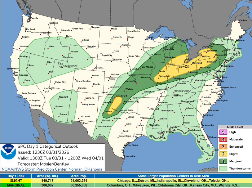
yup...had that look yesterday on guidance. Was waiting to see if SPC would expand the marginal and they just did
-
2026-2027 El Nino
snowman19 replied to Stormchaserchuck1's topic in Weather Forecasting and Discussion
Given the PDO changes since 2023-24 I very seriously doubt the PDO stays negative if we see a strong to super El Niño. Here is a really informative series of tweets from a Met out in Colorado. He is completely neutral and has zero bias for cold or warmth: -
2026-2027 El Nino
40/70 Benchmark replied to Stormchaserchuck1's topic in Weather Forecasting and Discussion
2004-2005 may be a fine analog if you account for the fact that El Nino will be stronger. -
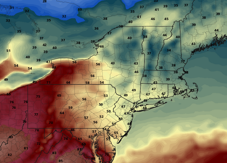
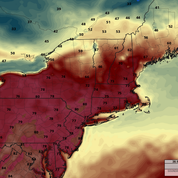
Looks like we will become a bit more unsettled starting today through Thursday. Will be a little help with it being bone dry.
-
6z nipped that back a bit…seabreeze look on the GFS and EC op. AIs not enthused.
-
Some EML in place. Could be a few decent bangers near and just north of front
-
Unfortunately ..we gotta get through Thursday first
-
looks light
-
ho man... 18z Saturday on the 00z Euro
-
another snowless March for many of us
- Today
-
Some stats for Winter '25-'26 for me: -One record low on 12/5 -Lowest temp of -10 on 2/9 with a total of 9 below zero lows, the most since '14-'15. 29 below 32 days, same as last winter, average is 22 for me. Longest streak of below 32 days was 9, the most since '17-'18. -Total snowfall is 46.3", which is +5.1" for me. I jinxed nyself with snowfall after I pushed all my banks back on 1/26. Below is the monthly snowfall and how it compares to average. -Nov snowfall: .2" (-1.5") -Dec snowfall: 17.0" (+7.6") -Jan snowfall: 21.3" (+11.4") -Feb snowfall: 6.6" (-7.5") -Mar snowfall: 1.2" (-5.2")
-
Yup. Pouring here although some of these reflectivities are brightbanding. Hopefully we can wetbulb assist this airmass to more forum members.


