All Activity
- Past hour
-

Septorcher 2026 Discussion - Endless Summer
WxWatcher007 replied to Damage In Tolland's topic in New England
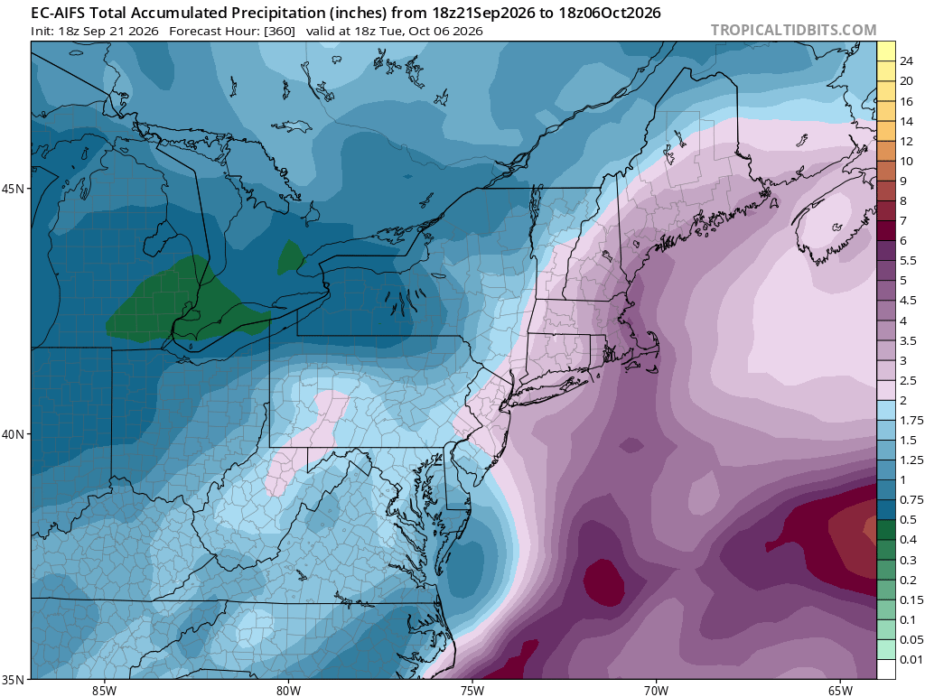
GFS twins are big hits especially in eastern NE. -
 medicine online or online pharmacy no prescription buy drugs online http://crewe.de/url?q=https://belvionpharmacy.com top-rated online pharmacies and https://vintage-car.eu/user/apklzwmwbs/ legitimate online pharmacy [url=https://community.strongbodygreenplanet.com/proxy.php?link=https://belvionpharmacy.com]trustworthy online pharmacy[/url] legitimate online pharmacy and [url=http://www.servinord.com/phpBB2/profile.php?mode=viewprofile&u=810368]pharmacy websites[/url] top online pharmacy
 -
Lots more rain on the way for the DMV. Look at the radar! Good luck to everyone.
-
best online ed pills [url=https://edboldrix.shop/#]Ed Boldrix[/url] best online ed meds
- Today
-
This is the coldest 60 degree high I can remember. Breezy NW wind, cloud cover keeping us cool, and even chillier after the sun set and the temp plummeted . Def not used to this kind of wx yet
-

Septorcher 2026 Discussion - Endless Summer
powderfreak replied to Damage In Tolland's topic in New England
Drought.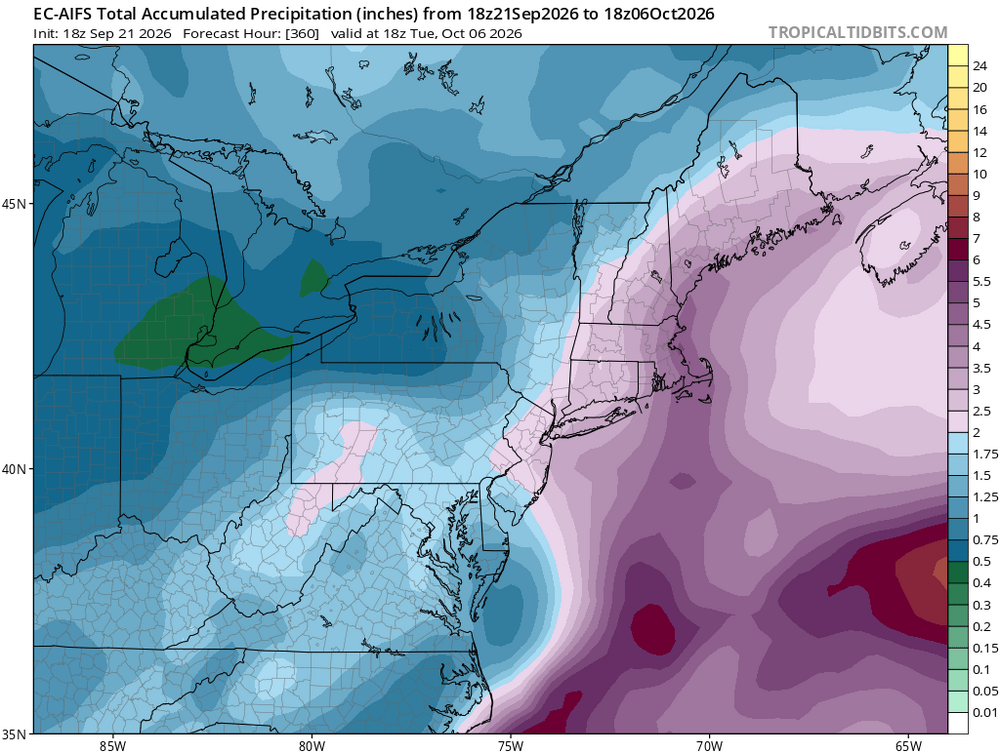
-
Septorcher 2026 Discussion - Endless Summer
Diggiebot replied to Damage In Tolland's topic in New England
High astronomical tides and long fetch will be the story. High Gusts will be on the coast and waves 15-20 maybe up to 30 or more feet could be major coastal flooding if it sets up right. Inland it’s rain as the big threat. Could easily be a dud inland tho. -
One other item concerning Polo. The only thing that may prevent record territory here is its slow, meandering movement in the next 24 hr. Yes, NHC notes the high OHC, however, when talking absolute records, everything typically has to be near ideal. The deep-layer 31 C SSTs, if that "only" falls to 30 C due to upwelling, that can be a factor. Still very intense, but 1 C difference in SST can be significant, in a relative sense, in this case, again when you are talking record territory.
-
Anniversary of both Long Island Express Hurricane-1938 and Hugo 1989.
-
By the end of this century, winters in Washington will resemble mid 20th century Greenwood, Mississippi, Greenville, Mississippi, or parts of California. While summers are likely to resemble mid 20th century Gulf Coast locations.
-
Do you guys think this is a good tool? I built this and it lets you compare all ThreadEx stations over the observed periods of 1895-1924, 1951-1980, 2016-2025, and then modeled 2041-2060 and 2081-2100. I picked these as they sample early 20th century means, mid to late 20th century means (also the normals that existed when I was born), recent anomalies, and then modeled projections for mid 21st and late 21st century. I used a relatively modest RCP2-4.5 forcing. I think they retired RCP5-8.5, but RCP3.3-7 is still in play (and some say recent forcings are closer to the high projections even if emissions are far short). And you can see how recent winters in Washington (or any other city) stack up against analog locations from 1951-1980. We can see for instance, recent winters in Washington resemble mid 20th century winters in places like Eugene, Oregon; Memphis, Tennessee; Norfolk, Virginia; Muscle Shoals, AL; and Huntsville, AL, with recent summers closely paralleling locations like Memphis, Savannah, or Daytona Beach. For the full year, Jonesboro, Arkansas is a close candidate, along with Muscle Shoals, Huntsville and Atlanta. Winter Summer Full Year
-
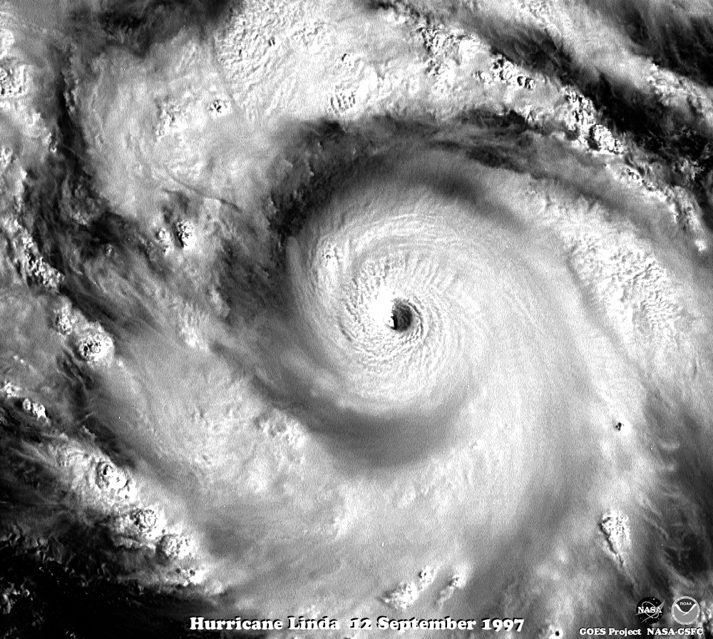
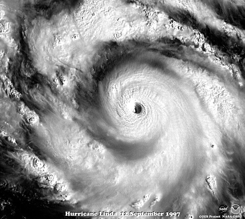
HU Polo is in an RI phase now, and it would not surprise me if it over-performs and gets to high-end (150-160 kt). This tends to occur in very strong El Nino. We had Patrica in 2015 and Linda in 1997. Linda never has a recon in when it was intense, sot its 160 kt peak is estimated, but it is likely it was higher than that. Look at this VIS image of Linda on 9/12/97. It was not as small as Patrica, but look at its CDO and very sharp subsidence ring around it. That is tell-tale sign of high-end intensity! Probably closer to 170 kt for a peak, but as I noted, NHC does not go above 160 kt for a TC in the absence of recon or other in situ data. The uncertainty when you get this intense is just too high, but one can say it was highly likely it was at *least* 160 kt!
-
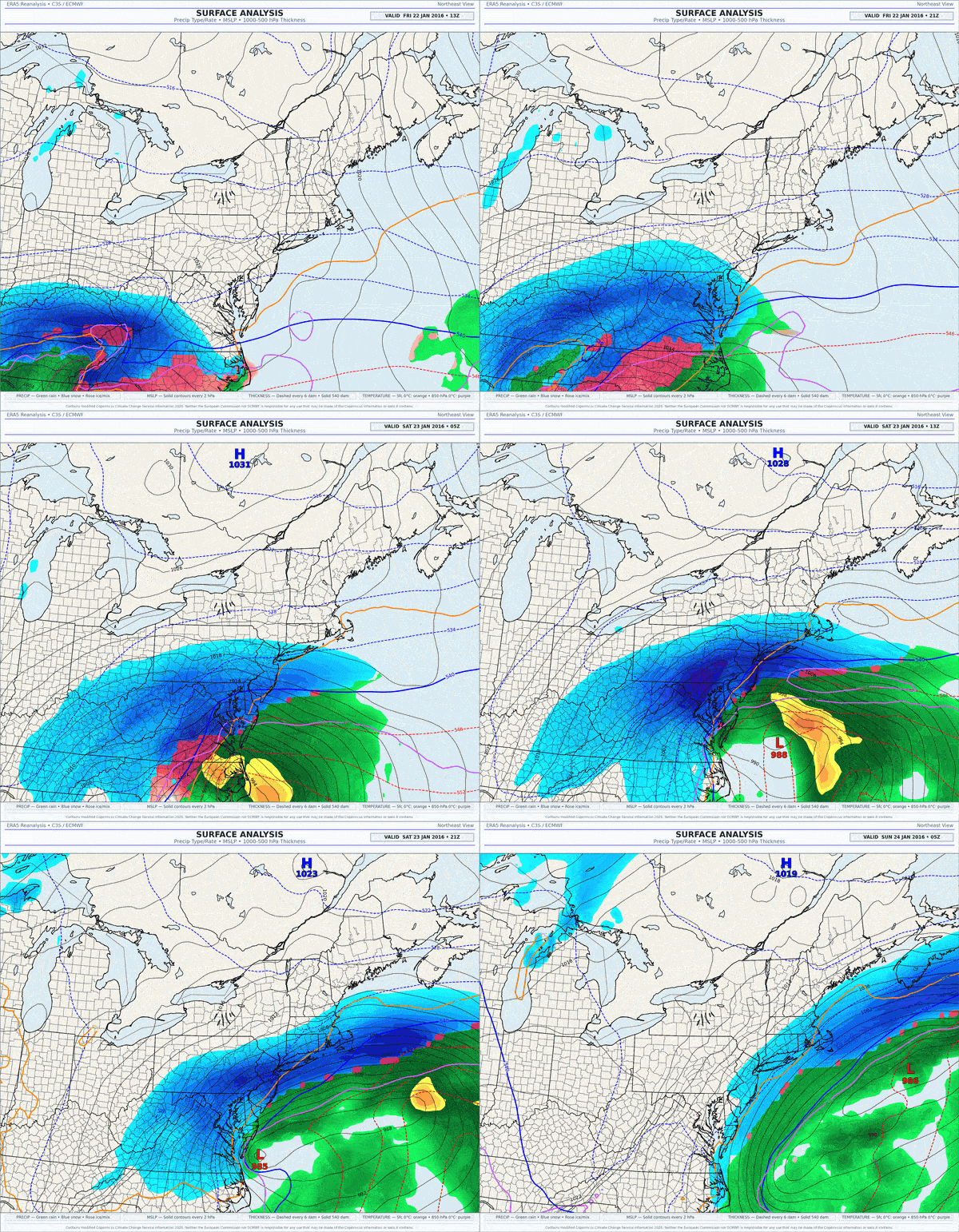
This winter, all it will take is one storm.
-
Maybe we can do a Jan 2024-like -NAO I do think there will be mean H5 ridging 60-90N this Winter. I'd give the odds of that happening at like 90%. May-Sept SLP 60-90N reverse for the Winter every time since 2012.
-

2026 Atlantic Hurricane Season
vortex95 replied to Stormchaserchuck1's topic in Tropical Headquarters
This short paper from 2007 (attached) from Chris Landsea of NHC summaries well the issues w/ "missing" TCs in the Atlantic. Counting Atlantic Tropical Cyclones Back to 1900 From the paper: In particular, Landsea et al. [2004] esti- mated an undercount bias of zero to six tropical cyclones per year between 1851 and 1885 and zero to four per year between 1886 and 1910. These undercounts roughly take into account the typical size of tropical cyclones, the density of shipping tracks over the Atlantic basin, and the amount of popu- lated coastline. As one goes back further in time, the numbers of ships and shipping lanes decreases and fewer people live in the tropical and subtropical coastal regions. These factors make it increasingly likely that some tropical cyclones would not be counted the farther back in time examined. I like how he compared 1933 to 2005, which is #1 and #2 for most ACE in a season. Look at the gap out in the cntrl and ern Atlantic. The 20 storms in 1933 I bet is at least 5-8 too low. We saw what happened in 2005 when everything went "right." We were getting late- season oddballs Oct-Dec often cntrl and ern Atlantic, and that season redefined what we call a TC and expanded what was possible! He said that as to hurricanes from 1851 to about 1940, anywhere from 0 to 4 hurricanes in the Atlantic were likely missed in any given year, w/ the avg being likely close to 1. Meaning that 1914 probably had a hurricane, just never detected. When you see something like Fay recently, and tiny systems like Oscar even when not in the middle of nowhere, you see how the probability is quite high here. It is fascinating stuff to look at history and do "sleuthing!" The Hurricane Reanalysis Project displays this best. I wish other agencies would do this for TC basin worldwide. There is *lot* of data out there that could be gathered, analyzed, and much to be found. And you do not have to go the far back. Full geostationary sat coverage did not exist in the western Pacific until 1987 and not until 1989 over the IO. However, for over 25 years up to this point, we had plenty of polar imagery, and as I mentioned, the delays in transmission of polar imagery in those days was several hours or more, so it could not be used operationally to assign proper TC intensity. It's the main reason why if you want to look at trends for TCs in the IO, you really can't start until 1990, and by extension, global TCs are well. The SIO is the second most active basin globally for ACE per year. landsea-eos-may012007.pdf -
https://belvionpharmacy.shop/# buy online medicine
-

Septorcher 2026 Discussion - Endless Summer
MarkO replied to Damage In Tolland's topic in New England
Warm core? -
I believe so. I have android, but saw a lot of posts on X today about carplay and the radar
-
Does it animate? The "my radar" app that comes with iPhones has been on CarPlay for a while but it will not animate for safety reasons. Let me know if Radarscope does. I'm thinking not?
-
lol yeah right on the cusp. Saturday is a long time from now too.
-
Got a quarter inch from last night's storm, narrowly avoiding that nasty hail pocket that went through to my south.
-
0.80” in my neck of dc.
-
All of the seasonal are going it...UK, JMA and CANSIPS, too....I take it as obviously overdone, but support for some second half volatility.
-
It's not like I take snowfall on seasonal guidance seriously.
-
Septorcher 2026 Discussion - Endless Summer
powderfreak replied to Damage In Tolland's topic in New England
Human evolution. Always building tools. It could be the invention of a hammer, or talking to AI, but our species is dedicated to solving every inconvenience. It’s our nature, even if it leads to negative consequences.



.thumb.jpg.ad3a2e31d30aff035044689b311a0540.jpg)