All Activity
- Past hour
-

July 2025 Discussion-OBS - seasonable summer variability
SACRUS replied to wdrag's topic in New York City Metro
Latest sst anomay (Atlantic) -
July 2025 Discussion-OBS - seasonable summer variability
SACRUS replied to wdrag's topic in New York City Metro
Records: Highs: EWR: 103 (2011) NYC: 104 (1977) LGA: 100 (2019) JFK: 99 (2019) New Brnswck: 102 (1930) Lows: EWR: 56 (1951) NYC: 55 (1890) LGA: 62 (1974) JFK: 58 (1965) New Brnswck 51 (1966) Historical: 1911 - The temperature at Painter, WY, dipped to 10 degrees to equal the record low for July for the continental U.S. (The Weather Channel) 1930: The state record for Delaware was established that day with a reading of 110 °F at Millsboro, Delaware. (Ref. Lowest and Highest Temperatures for the 50 States) 1934 - The temperature reached 109 degrees at Cincinnati, OH, to cap their hottest summer of record. The state record for Ohio was established that day with a reading of 113 degrees near the town of Gallipolis. (David Ludlum) 1939: Richmond, Virginia had a high temperature for the day of 65 °F making it the coolest July day on record (records since 1897). (Ref. Richmond Weather Records) 1942: This is the only occurrence Miami, FL has ever seen 100°. (Extreme Weather p. 273, by Christopher C. Burt) 1947: Holt, MO records world record 12 inches of rain in only 42 minutes.(Ref. Wilson Wx. History) 1975 - Six inches of rain fell across Mercer County, NJ, in just ten hours causing the worst flooding in twenty years. Assunpink Creek crested eleven feet above flood stage at Hamilton and Trenton, the highest level of record. Traffic was brought to a standstill, and railway service between New York City and Washington D.C. was cut off for two days. Flooding left 1000 persons homeless, and caused an estimated 25 million dollars damage. (David Ludlum) 1979: Parts of Lancaster County into the west central Chester County, Pennsylvania region was hit with torrential rain during the morning, with most of the rain falling in about 5 hours. In Chester County, Newlinville received 8.11 inches and Valley Township 7.56 inches. (Ref. Wilson Wx. History) 1986: A tremendous heat wave continued across the South. This was the 15th day in a row with 100° plus degree readings at Columbia, SC. Macon, GA topped out at 106 °F. It was also the 10th consecutive day with 100° degree plus heat at Macon. (Extreme Weather p. 273, by Christopher C. Burt) (Ref. Wilson Wx. History) 1987 - Thunderstorms produced severe weather from Utah to North Dakota, spawning a dozen tornadoes in North Dakota. Thunderstorms in North Dakota also produced baseball size hail at Clifford which caused four million dollars damage, and high winds which toppled a couple of eighty foot towers cutting off power to the town of Blanchard. (The National Weather Summary) (Storm Data) 1988 - While cool air invaded the central U.S., unseasonably hot weather continued over the western states. The temperature at Spring Valley, NV, soared from a morning low of 35 degrees to an afternoon high of 95 degrees. Fallon, NV, reported an all-time record high of 108 degrees, and Death Valley, CA, reported their sixth straight day of 120 degree heat. (The Weather Channel) (The National Weather Summary) 1989 - Afternoon thunderstorms over Florida produced wind gusts to 92 mph at Jacksonville, damaging thirteen light planes at Herlong Field. Five cities in Texas reported record low temperatures for the date. Corpus Christi, TX, equalled their record low for the date with a reading of 71 degrees, and then tied their record high for the date that afternoon with a reading of 97 degrees. (The National Weather Summary) (Storm Data) 1991: Boston, MA recorded 81 °F for the warmest low temperature. 100 degree readings are not common in Rhode Island, but the mercury topped out at 102° at Providence on this day, the second day in a row that the thermometer reached the century mark. (Ref. NOAA Boston Weather Events) 1993: The Mississippi River crested at 46.9 feet at St. Louis, MO, easily breaking the old record of 43.2 feet established in the 1973 flood. The 11 mile long, 52 foot high flood wall kept water out of the city center. In spite of all the damage the flood did, it is estimated that without all of the flood-control measures in place today, the price tag from the flood would have easily doubled its astronomical $20 billion total. The record crest would be topped again on August 1st. The heavy rainfall that occurred earlier in the month set the stage for what became the flood of the century in Iowa. The city of Des Moines was very hard hit. At the peak of the flooding, nearly 35,000 households were without electricity and 50,000 were without power. Water service was out for 250,000 people, which is the largest water outage in United States history. Losses to the businesses in Des Moines were estimated at $800 million dollars, from physical damage to the buildings and lost business. Other damage in Des Moines included $30 million dollars to homes, $75 million dollars to the levee system and $20 million dollars to the water treatment plant. Damage to West Des Moines was also well over $30 million dollars. Crop damage was extensive as 6.5 million acres of cropland were damaged by the flood. (Ref. Wilson Wx. History) 1995: A camper at Colonial Beach in Westmoreland County, VA took refuge under a tree during a thunderstorm. The tree was struck by lightning, which in turn caused second degree burns over 20 percent of the camper's body. (Ref. Lightning - Virginia Weather History) 1997: Extreme flooding occurred over Baldwin County, Alabama as the remnants of Hurricane Danny drifted slowly northeastward after dumping 30 inches of rain over coastal Alabama. The worst flooding occurred around the Fish River where 500 homes were damaged. (Ref. Wilson Wx. History) 1999: The Cedar River in Charles City, IA reached its all-time crest of an estimated 22.8 feet. Approximately 100 homes had flood damage in Charles City. Almost 12 inches of rain fell in a 48 hours period over these counties. Rainfall totals that day: New Hampton, IA: 7.10 inches (wettest day on record), Charles City, IA: 6.65 inches, West Union, IA: 4 inches. (Ref. Wilson Wx. History) 2006: Western Washington: An unusual heat wave in western Washington breaks five maximum temperature records: Vancouver at 104°F, Olympia at 100°F, Seattle at 97°F, and Hoquiam at 90°F. (Ref. WxDoctor) 2011: at 4:50 PM Chicago bakes in first back-to-back 100-degree days in 16 years since deadly heat wave in July 1995 The mercury hit 101 degrees at Midway Airport at 4:40 pm Thursday afternoon marking the second straight day of triple-digit heat there. This was the city's first encounter with back- to-back 100-degree days in 16 years since the deadly heat wave of July 1995. Back then the mercury soared to 106 degrees on July 13 and was followed by a 102 degree high on July 14. The city's official site at O'Hare Airport has fallen just short of triple-digit heat for the second straight day. Today official high there was 99 degrees recorded at 1:58 pm. On Wednesday the 20th the city's official high at O'Hare international Airport was also 99 degrees. (Ref. WGN Chicago Weather Center - Tom Skilling) -

2025-2026 ENSO
40/70 Benchmark replied to 40/70 Benchmark's topic in Weather Forecasting and Discussion
I understand that the standard for what is "cold" keeps lowering as climo warms....that is irrelevenet when forecasting anaomlies. I am not speaking in terms of absolute temps...simply departurers relative to current climo. -
2025-2026 ENSO
40/70 Benchmark replied to 40/70 Benchmark's topic in Weather Forecasting and Discussion
I think the issue maybe that you are referring to actual temperature, when most forecasts are issued based on anaomalies relative to the current climate period. I guess this disconnect is what is "nebulous" and the source of said "obfuscation". No one argued that it was a particularly cold winter...the point is that it took a relatively lengthy interlude of cold to register even near normal per 1991-2020. This was more than a merely a mismatch period along the lines of 2021-2022, which was even wamer. -
From a 8th floor balcony in OC, I've seen anvil tops for a storm as far west as Frostburg. I was pretty shocked how far away it was.
-
Watched the rain split and go north and south as it approached over the weekend. Managed to get a tiny lone cell after the main even to swing through and bring about 0.1" of rain. Other than that pretty much missed out on everything else. That D1 drought is going to be approaching D2 levels pretty soon.
-
July 2025 Discussion-OBS - seasonable summer variability
SACRUS replied to wdrag's topic in New York City Metro
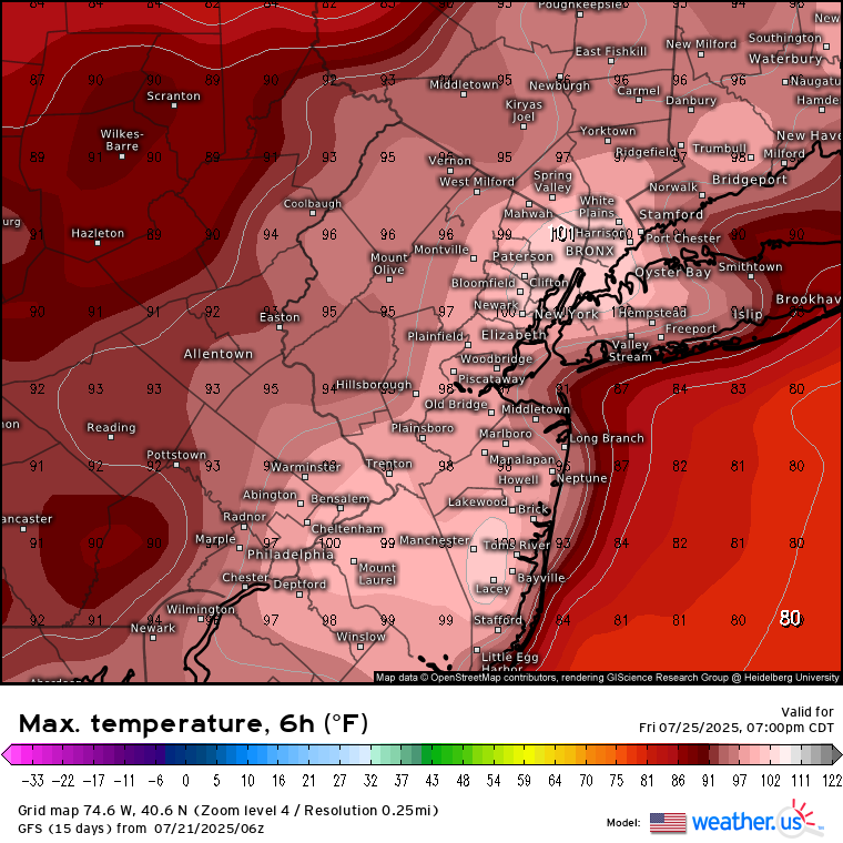
76 / 64 clear. Hello sunshine - nice stretch of weather coinciding with peak summer. Mid/ upper 80s, stray 90 in the hot areas today, much drier. Tuesday low - mid 80s and a touch warmer Wed mid 80s for most, some upper 80s in the hot spots. Ridge builds in raising heights >594 DM and heat by Thu and through the upcoming weekend, strong heat Fri / Sat (pending on clouds) and Sun (if enough clearing). By Monday the ridge is pulling west and while heights remain elevated some onshore undercuts the ridge for us to close the month. Ridge centered in the MS valley (ish), spells overall war -hot and wetter with heat expanding east by the 3rd. 7/21 - 7/23 : Sweet stretch drier, sunny, warm (cooler) 7/24 - 7/27: Hot, humid , strong heat (95+) Fri / Sat. Storms focus on Sat PM/ Sun 7/28 - 8/2 : Warm - Hot and wetter overall - Onshore 8/3 - Beyond : Hotter -

July 2025 Discussion-OBS - seasonable summer variability
bluewave replied to wdrag's topic in New York City Metro
Our next chance of 100° heat coming on Friday.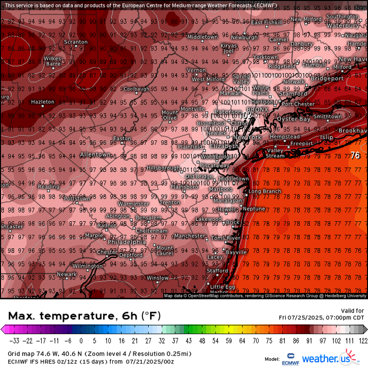

-
No change here yet. Just another cloudy, wet, humid morning.
-
-
Even KNAK listed a DP of 68, but my personal swamp still clinging to 73 DP as of 7am
-
I am not sure what you mean by using the term nebulous and obfuscate. The issue with relying on modern standards based on 30 year climate means are that they are continuously getting warmer every 10 years. So the bar is lower for defining a colder winter. A departure isn’t the actual temperature. My whole point by using long term rankings back to 1895 is that it’s a fixed number which everyone can relate to. The 3 month average last winter was in no way shape or form considered cold for the CONUS. It was the 27th warmest winter on record for the CONUS at 34.07°. But I agree with you that is was a cold January overall for the CONUS at 33rd coldest and 29.21°. The temperatures rebounded in February to 34.81° or 54th warmest. But there were still some localized cold pockets out West in February. The storm track for NYC last winter was very warm. On the 11 days which .25 or more of precipitation fell the average temperature was 41.0°. This is why the snowfall was so low again continuing the pattern since 2018-2019. The climate periods with similar temperatures going back to the 1970s had very distinct average temperatures across the CONUS and various regions. The first period from 1895 to 1982 had a much colder temperature range. So during each succeeding climate period the coldest winter have been getting warmer at a slightly faster pace than the warmest winters have been getting warmer. This recent 10 winter year period since 2015-2016 has been unprecedented in the modern climate history of the CONUS. There has been no 10 winter period this warm. This is especially the case when looking at how fast the coldest winters have been warming. Coldest winters by decade 2020s so far….33.64° 2010s…………..30.70° 2000s…………..31.26° 1990s……………31.80° 1980s…………...30.56° 1970s……………26.62° 1960s……………30.65° 1950s……………31.44° 1940s……………30.14° 1930s…………...27.78° 1920s…………...28.73°
-
For second day in a row, JUST missed a 'warm minimum' for the date. 69.2 low, record is 69.9 from 2015. Currently 70.2/69.4 at 8 am with cloudy skies.
-
.05” of precipitation yesterday. Beautiful morning out 62° for the low.
-

2025 Atlantic Hurricane Season
BarryStantonGBP replied to BarryStantonGBP's topic in Tropical Headquarters
Seems to be the new normal -
2025 Atlantic Hurricane Season
BarryStantonGBP replied to BarryStantonGBP's topic in Tropical Headquarters
Mate I’m brand new here don’t know what you’re on about -
What should be the best Meteor shower days this month?
- Today
-

July 2025 Obs/Disco ... possible historic month for heat
moneypitmike replied to Typhoon Tip's topic in New England
Perfect coc day today. -

July 2025 Obs/Disco ... possible historic month for heat
kdxken replied to Typhoon Tip's topic in New England
Heatwave looks doable in spots at the end of the week. -
2025-2026 ENSO
40/70 Benchmark replied to 40/70 Benchmark's topic in Weather Forecasting and Discussion
Its not going to be an official La Nina, but that doesn't matter...agree otherwise. -
2025-2026 ENSO
40/70 Benchmark replied to 40/70 Benchmark's topic in Weather Forecasting and Discussion
I think its still going to be a pretty costly season due to a late home-brew barrage. -
2025-2026 ENSO
40/70 Benchmark replied to 40/70 Benchmark's topic in Weather Forecasting and Discussion
I kind of get some 2007-2008 vibes for the coming winter.... -

2025-2026 ENSO
PhiEaglesfan712 replied to 40/70 Benchmark's topic in Weather Forecasting and Discussion
Yeah, even without the blocking, we still had one final hurrah during the final third of March. 2011-03-23 40 32 36.0 -8.8 29 0 0.87 T 0 2011-03-24 44 30 37.0 -8.2 28 0 0.09 1.0 1 2011-03-25 42 28 35.0 -10.5 30 0 0.00 0.0 0 2011-03-26 40 26 33.0 -12.9 32 0 0.00 0.0 0 2011-03-27 45 28 36.5 -9.7 28 0 0.00 0.0 0 2011-03-28 45 26 35.5 -11.1 29 0 0.00 0.0 0 2011-03-29 49 31 40.0 -6.9 25 0 0.00 0.0 0 2011-03-30 53 36 44.5 -2.8 20 0 0.01 0.0 0 2011-03-31 43 37 40.0 -7.7 25 0 0.13 T 0 This turned a solid warm first two-thirds of the month into a negative departure. -
July 2025 Obs/Disco ... possible historic month for heat
kdxken replied to Typhoon Tip's topic in New England
-

July 2025 Obs/Disco ... possible historic month for heat
HoarfrostHubb replied to Typhoon Tip's topic in New England
What? What? I can’t hear you! Def a good porter. They need to sell snacks though.