All Activity
- Past hour
-

October Comes Early: Late September Multi-Hazard Hybrid Storm
kdxken replied to WxWatcher007's topic in New England
Heavy drizzle/light rain. Miserable. Beginning to understand why they regulate handgun sales so tightly in the UK. -

October Comes Early: Late September Multi-Hazard Hybrid Storm
Baroclinic Zone replied to WxWatcher007's topic in New England
Been raining off and in since about 2am. -

October Comes Early: Late September Multi-Hazard Hybrid Storm
CoastalWx replied to WxWatcher007's topic in New England
Pouring again. -

Septorcher 2026 Discussion - Endless Summer
Brewbeer replied to Damage In Tolland's topic in New England
Septorcher bust -

2026-2027 Record-breaking El Nino
bluewave replied to Stormchaserchuck1's topic in Weather Forecasting and Discussion
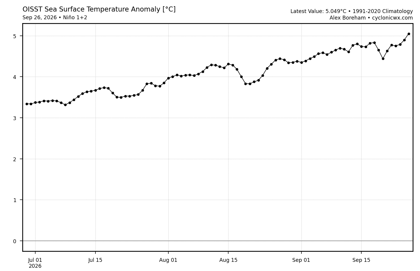
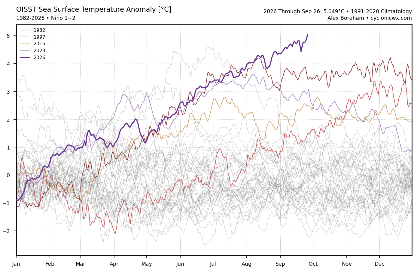
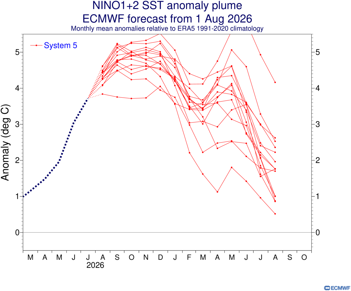
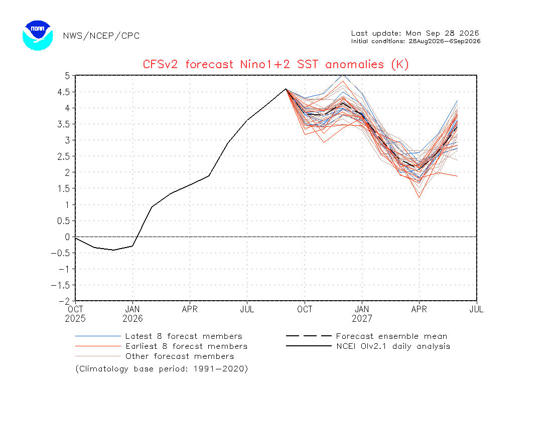
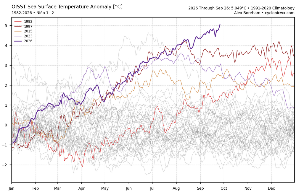
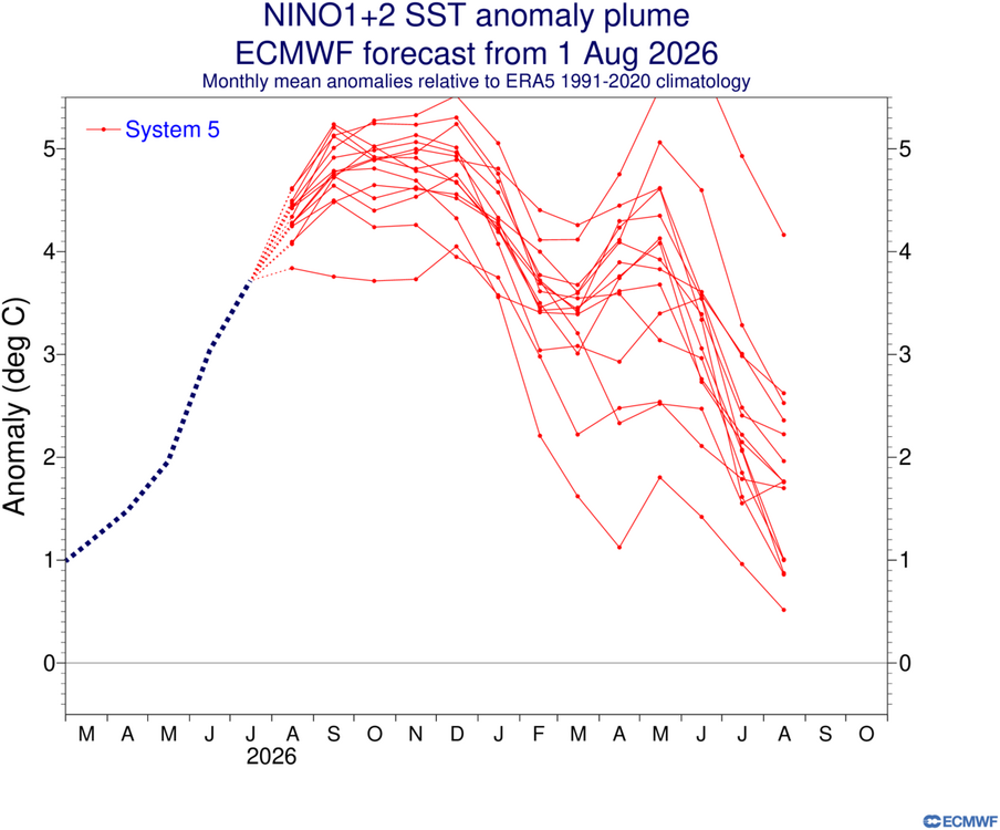
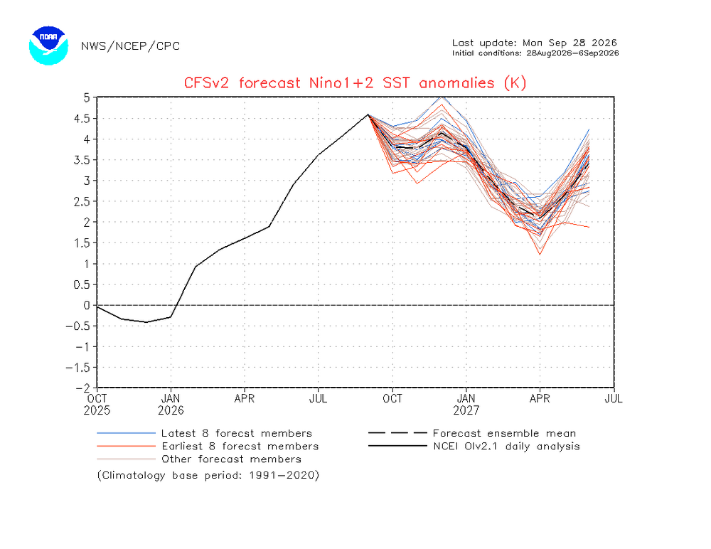
Even though the CFS forecast was too weak with the current all-time daily +5 Nino 1+2, it has a 2nd peak late next spring into the early summer. These very long range forecasts aren’t as accurate. But even the Euro extended is showing something similar. 1982-1983 had a second Nino 1+2 peak in June 1983 which was stronger than the one from the fall. But this fall is so much stronger than 1982 that the models have a lower peak late next spring. The 1983-1984 La Niña was significantly weaker than 1998-1999 since it got off to such a late start with a much weaker cold pool. We’ll get a new update on October 5th to see if it has the same forecast idea from the August 5th extension. The Euro was much closer to the current +5 than the CFS.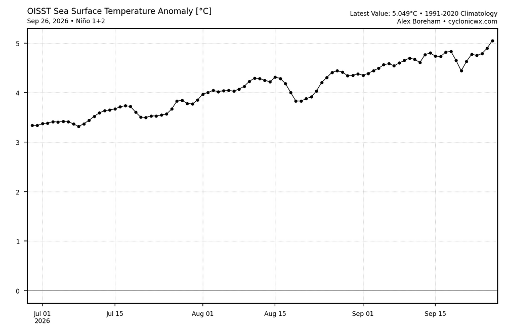
-
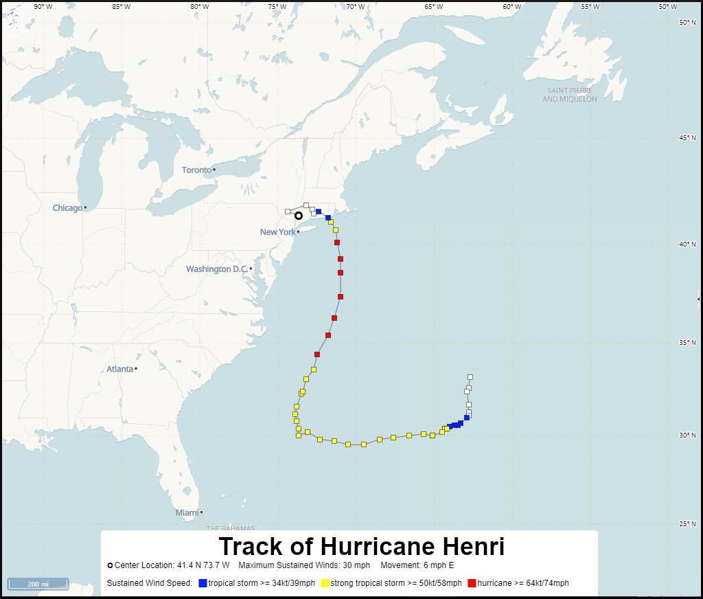
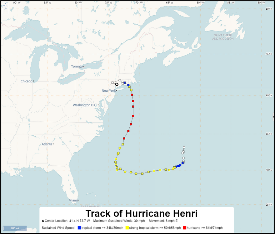
Sandy was obviously the most extreme since it was such a strong system which occurred at the end of October in 2012. Henri was another much weaker system to come in from the east but was further north than this event. Henri lead to record flash flooding in August 2021. So these much stronger blocks to our north make these type of tracks possible. https://storymaps.arcgis.com/stories/693bb9ddab5b4fb3a4aa5b79e5435b9f
- Today
-
It's a lot more than milder. Mid to upper 80s late week
-
 Cialis over the counter: Tada Stream - Generic Cialis without a doctor prescription
 -
58 degrees this morning.
-
Cheap Cialis: TadaStream - Tadalafil price
-
Saturday - .54" Sunday - .53" Monday - .03" so far Total Storm - 1.10"
-
buy cialis pill: Tada Stream - Buy Tadalafil 5mg
-
.thumb.jpg.aec747d13df1d95d5fed34574f74d4fd.jpg)
October Comes Early: Late September Multi-Hazard Hybrid Storm
Vinny Findley replied to WxWatcher007's topic in New England
5.02 in Cranston near the Johnston Providence line. Storm was mostly quick bursts of heavy rain then light to moderate and heavy drizzle. -
Nolo is looking spectacular this morning and well on its way to becoming another 2026 EPAC/CPAC Category 5.
-

October Comes Early: Late September Multi-Hazard Hybrid Storm
moneypitmike replied to WxWatcher007's topic in New England
7.01 as of 4:00am -
It's long overstayed its welcome Naming storms just isn't an objective scientific process. We blame the weather channel for their silly naming scheme but the NHC can be criticized too. Plenty of storms in years like 2005 and 2020 that would not have been named in the 50s and 60s and prior years. I'm sure 1933 would have had a lot more. It's a lot like snowfall measuring. Oh and there was an intentionally not named hurricane during the Perfect Storm October 1991 and that December 1994 storm should have been named too. That one was far stronger than this one. I think Chris posted a video with Dr. Joe Sobel in it? It would have been all rain at the coast just like December 1992 was but much less impact than that historic storm. Stadium effect? I wonder if it behaved like the eye of a hurricane? Landfall location near Tom's River? Well now it's just tedious and boring. This thing has long overstayed its welcome and become tedious and boring. I can't wait until humans control the weather and kick these things out. Still got rain here, sometimes heavy. It's a hybrid. These kinds of storms don't belong in September they should not happen before late October. Tony from that satellite image it looks like the center crossed farther south between Atlantic City and Tom's River. So all snowfall, rainfall and temperature records from before 1999 are suspect? Well damn they were just saying how today's rainfall record is from Hurricane Gloria in 1985. 6 inches of rain in a storm that moved quickly and tracked further to the east than this one. What about temperature records from very cold winters like 1993-94 and very hot summers like 1980, 1983 1988, 1991, 1993, 1995, 1999? And those snowfall records from 1987 1988, 1993 1994 and 1996?
-
Cialis 20mg price: TadaStreamRx - cialis for sale
-
ed pills cheap: ApexMen Meds - buy erectile dysfunction medication
-
best ed medication online [url=http://apexmenmeds.com/#]Apex Men Meds[/url] cheapest ed medication
-

September 2026 Medium/Long Range
Stormchaserchuck1 replied to JenkinsJinkies's topic in Mid Atlantic
1:1 correlation with Strongest El Nino on record. Record low ACE to date too. -
What happened to Mark Andrews 1yd QB sneaks? They worked so good last year, I think worked every single time. Not using it almost costed the game.
-

2026-2027 Record-breaking El Nino
GaWx replied to Stormchaserchuck1's topic in Weather Forecasting and Discussion
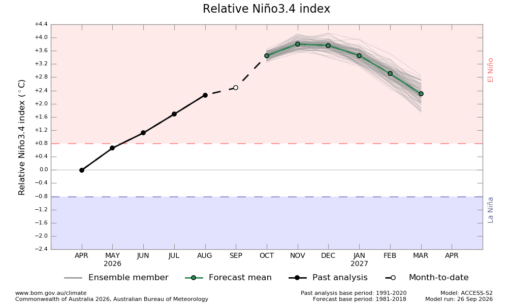
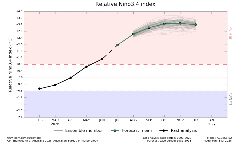
Ok, here we go again with the BoM RONI progs. As I’ve posted, the early near month prog of every near month of Apr-Aug ended up having been too warm as per their charts showing notably cooler in their final analyses vs these early progs. I now feel safe in saying that that’s happening with Sep, too, which would make 6 months in a row! Here was a Sep 5th prog, which had Sep near +3.0: Compare that to the brand new run (Sep 26th…see below), which has Sep MTD at only +2.4 with only 5 days to go (note the line from Aug to Sep is almost flat vs the steep slope of the Sep 5th run)! To compare, NOAA appears to be headed to a Sep of only ~+2.0 to +2.2. We’ll see next week where Sep. settles for both BoM and NOAA. I bet BoM settles at ~+2.5 or +2.6, well below its Sep 5th run’s +3.0 prog. Thus, I continue to expect that the ~+3.8 peak that it still shows for Nov will end up not verifying even closely. Before that, I predict with confidence that the +3.5 of Oct won’t verify closely. Why would the clearcut pattern of significantly too warm near month progs change now? Besides, it would take pretty much a record warming for a one month period to reach from Sep’s mid +2s to Oct’s +3.5. Sound familiar? Several models earlier had predicted a record warming from July to August, which we know ended up busting badly. To show how out of touch with reality this has been the last 3 months, this Jul 4th run had July at +2.0, Aug at +2.7, and Sep at +3.0. Jul/Aug BoM verified at only +1.7/+2.3 and Sep should verify only in the +2.5 to +2.6 area as mentioned. This warm bias is Déjà vu from 2023: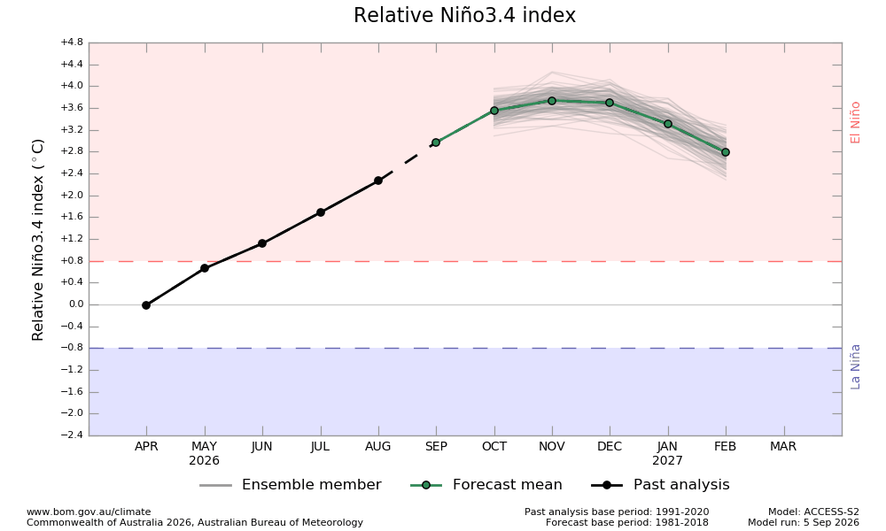
-
super el nino banter thread
Stormchaserchuck1 replied to forkyfork's topic in Weather Forecasting and Discussion
Too much attention on typhoons. What's more important is subsurface, especially near the thermocline. Why should a shallow layer of water on top control the atmosphere? -

October Comes Early: Late September Multi-Hazard Hybrid Storm
40/70 Benchmark replied to WxWatcher007's topic in New England
Repeat of the blizzard...same spots hammered, same spots T-boned. TBH, I'm just fine with expending this bullet from the chamber now, in the early autumn. -
October Comes Early: Late September Multi-Hazard Hybrid Storm
40/70 Benchmark replied to WxWatcher007's topic in New England
1.06" rainfall on the day in Methuen. .58" Saturday, .03" Friday for a 3-day event total of 1.67"