All Activity
- Past hour
-

Central PA Spring 2025
Mount Joy Snowman replied to canderson's topic in Upstate New York/Pennsylvania
Low of 62 and a 3-day rain total of exactly 1.50”. Grass is looking lush. -
Don't forgot to try some New Haven Apizza. I like Bar and Modern Archie Moore's has the best wings in New Haven as well. Please don't go to Wingstop. Also, long wharf across from IKEA has dozens of really good food trucks along the water.
-
I see the GFS with the first Atlantic cane of the season
-
The rain might be great for some veggies but my newly bloomed red roses look all mangled right now.
-
Rainfall totals Fri through 0600 NYC: 1.10 EWR: 0.43 JFK: 0.41 New Brnwck: 0.36 LGA: 0.13
-
it's bad enough for most of the week to be wet, but another friggin Saturday!! C'mon man
-
This is a perfect time to be getting rain like this with full leaf out occurring and help get rid of the green crap everything is coated in.
-
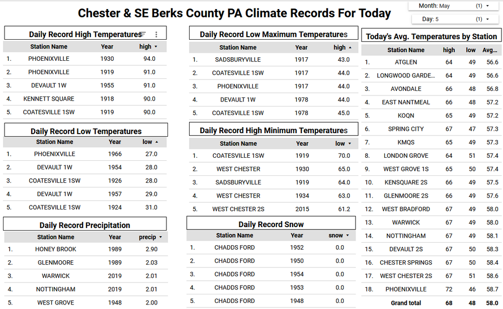
Records: Highs: EWR: 94 (1949) NYC: 90 (1980) LGA: 90 (1955) JFK: 84 (1980) Lows: EWR: 38 (1966) NYC: 34 (1891) LGA: 42 (1978) JFK: 41 (2002) Historical: 1917 - The same storm which a day earlier produced eight inches of snow in the Texas panhandle, produced a foot of snow at Denver CO, their heaviest snow of record for the month of May. (David Ludlum) 1930 - The temperature at College Park, VA, soared from 43 degrees to 93 degrees to begin an exceptional heat wave. (Sandra and TI Richard Sanders - 1987) 1933: An estimated F4 tornado cut a 35-mile path from near Brent into Shelby County, Alabama. The town of Helena, AL was especially hard hit, as 14 people died. The tornado roared through Helena at 2:30 am. 1987 - Unseasonably hot weather prevailed in the western U.S. A dozen cities in California reported record high temperatures for the date. Afternoon highs of 93 degrees at San Francisco, 98 degrees at San Jose, 100 degrees at Sacramento, and 101 degrees at Redding, were the warmest of record for so early in the season. The high of 94 degrees at Medford OR was also the warmest of record for so early in the season. (The National Weather Summary) 1987 - Parts of the western U.S. were in the midst of a blistering May heat wave. The reading of 100 degrees in Downtown Sacramento CA was their earliest of record. Sacramento CA established daily record highs on nine of eleven days between the 4th and the 14th. (The Weather Channel) 1988 - A stubborn low pressure system continued to drench the eastern U.S. with rain. Thunderstorms again produced large hail in North Carolina. (The National Weather Summary) 1989 - Thunderstorms swept across Georgia and the Carolinas during the late afternoon and evening hours spawning seventeen tornadoes. A tornado at Toccoa GA injured 15 persons, and a tornado at Chesnee SC killed two persons and injured 35 others. Five tornadoes in North Carolina accounted for five deaths, 88 injuries, and sixty million dollars damage. Thunderstorms also produced baseball size hail at Lake Murray SC, and wind gusts to 78 mph at Brooklyn MD. (The National Weather Summary) (Storm Data) 1990 - A strong Pacific cold front moving rapidly inland caused weather conditions at the east end of the Strait of Juan de Fuca in Washington State to quickly change from sunny and calm to westerly winds of 60 mph and ten-foot waves. Three recreational fishing boats capsized in heavy seas off Port Angeles resulting in five deaths. In California, temperatures soared above 90 degrees across much of the state. The high of 101 degrees in downtown Los Angeles was eight degrees hotter than their previous record for the date. (The National Weather Summary) (Storm Data) 1995: A supercell thunderstorms brought torrential rains and large hail up to four inches in diameter to Fort Worth, Texas. This storm also struck a local outdoor festival known as the Fort Worth Mayfest. At the time the storm was the costliest hailstorm in the history of the US, causing more than $2 billion in damage.
-
I was turning 10 years old and we had just moved into a new house and I was enjoying the central air and our big back yard with large pine trees and acorns lol where I played ball. Great memories!!
-
why are we getting so many cut offs, this belongs in March lol
-
Just wait til we get to Friday and Saturday when we might be in the 40s at night.
-
It was as if we crossed an invisible threshold in 2023. Perhaps the oceans just reached the point where they could no longer absorb the excess heat anymore. Almost like filling a glass with water and not seeing much of an issue until it starts spilling over the rim. So the excess heat is being released into the atmosphere instead of staying put in the oceans. Non-linear or threshold effects usually only become known once the barrier has been crossed. This is the risk of treating climate change solely as a linear gradual process which has lead to climate complacency.
-
61 / 59 misty. Ugly two days 1 - 3 inches depending where you are as the ULL cutoff moves through. Temp break Wed with some sun. Trough slides south into the northeast cut off later Thu through Sat AM with the next round of rain. A nice Mother day looks on tap. Beyond there the period 5/10 through mid month looks near normal before potentially more ridging into the week 20.
-
days and days and days.
-
-
A gloomy start to the new work week with some drizzle and showers across the area. The European and GFS have around 0.50" of rain by Wednesday morning...but higher amounts are possible if we see some thunderstorms tomorrow afternoon. High temperatures will be close to normal in the upper 60's to low 70's. We turn much chillier by the end of the week as Friday highs may struggle to escape the 50's for higher spots in the area.

-
3 day storm total is slightly under .50 for me
-

E PA/NJ/DE Spring 2025 Obs/Discussion
ChescoWx replied to PhiEaglesfan712's topic in Philadelphia Region
A gloomy start to the new work week with some drizzle and showers across the area. The European and GFS have around 0.50" of rain by Wednesday morning...but higher amounts are possible if we see some thunderstorms tomorrow afternoon. High temperatures will be close to normal in the upper 60's to low 70's. We turn much chillier by the end of the week as Friday highs may struggle to escape the 50's for higher spots in the area.
-
one of my favorite summers of all time....13 and what an incredible year and music and days and days of watching mtv and then going outside doing what 13 years old do and coming in at night with air conditioning downstairs to watch endless amounts of music videos
-
Manhattan radiates really well, I am not surprised you dipped into chilly temps.
-
I do....belle mead in da house
-
.thumb.jpg.6a4895b2a43f87359e4e7d04a6fa0d14.jpg)
Central PA Spring 2025
Yardstickgozinya replied to canderson's topic in Upstate New York/Pennsylvania
We are only marginal in terms of risk today but here's is spc take on today. ...Central Appalachians and Mid-Atlantic... Recent surface observations reveal a residual front/marine boundary draped from eastern VA into the eastern Carolinas. East of this boundary, richer low-level moisture in the form of low to mid-60s dewpoints is noted extending northward into southeast PA. Aloft, an embedded shortwave orbiting around the primary upper low is noted over the mid-MS River Valley in recent water-vapor imagery. This feature is expected to pivot into the Mid-Atlantic and central Appalachians through the afternoon/evening and will be favorably timed with the diurnal heating cycle. The combination of cold temperatures aloft in proximity to the upper low and rich low-level moisture will limit capping and promote thunderstorm initiation along the boundary by early afternoon from the DelMarVa region into NC. Further to the northwest, lift ahead of the embedded shortwave combined with cold mid-level temperatures should promote thunderstorm development across WV and OH by late afternoon. Across both regions, 1000-1500 J/kg MLCAPE and elongated, nearly straight hodographs should promote organized cells capable of large hail and damaging winds. Similar thermodynamic and kinematic environments were observed yesterday across the region, and yielded isolated to scattered strong to severe thunderstorms, including a couple of supercells -

2025-2026 ENSO
40/70 Benchmark replied to 40/70 Benchmark's topic in Weather Forecasting and Discussion
If we do maintain coolish ENSO this year, don't sleep on 2000-2001 as a contender next season...take a deep dive into the prominent +PNA in the respective seasonal means that burst onto the scene to lower the curtain on a robust Pacific cold phase each in case. QBO seems to aligning well, too. If its warmish ENSO, there were obviously some similarities to 2013-2014 this past season, despite the east coast screwgie on snowfall. The QBO also looks to align with 2014, which just so happened to herald in a warm Pacific interlude following a potent cold phase that began in 2010. No...I don't expect 130" of snowfall in Worcester, MA or 100" in 30 days in Boston, so lets get that out of the way before the bun assault ensues....the validity of the 2013-2014 analog last year was a wonderful lesson in the value of an analog despite some notable differences in sensble weather for particular regions, especially with regard to high variance elements such as snowfall. -
Mild and himid this morning. It looks like some storms are trying to move towards the rain defense system over my area. Edit: And poof it goes as usual lol
-
Heading down to New Haven for the day... Going to IKEA (never been) and Wingstop (also never been)to make the most out of a rare day off work Sent from my SM-S156V using Tapatalk


