All Activity
- Past hour
-
Time for some addition now that the Great Heat of August '25 has ended. Days 90° or above at the the majors: Worcester - 0 Providence - 1 Boston - 2 Hartford - 3 (non-consecutive) Anywhere north of route 2 - 447
-
Enjoy your vacation! I’ll look forward to hearing about how it went when you return.
-
-
Another fantastic night in the 70s here on the shoreline. BDR and HVN 74 for the low.
.thumb.png.16730ce50209da83b7d4d0e7a7502adf.png)
-
Embrace the coc, it’s the only coc you have.
-
Sure…like I said, after Monday. Work weeks looking more COCish and weekends torchy.
-
A “La Niña Watch” has been issued by the CPC/NOAA; expecting La Niña conditions come fall into early winter before going back to cold-neutral conditions by late winter into early spring…..
-
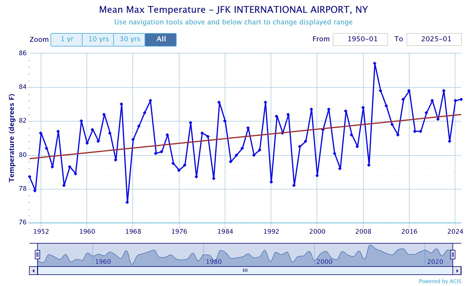
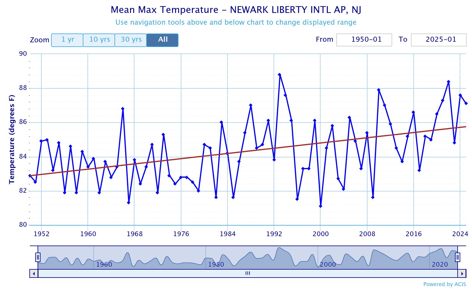
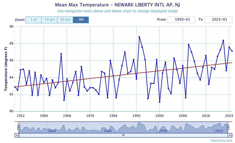
 The summer high tempersrures at JFK and Newark are rising at a similar rate. But JFK is still 4° cooler for summer highs than Newark since it’s right on the water with more sea breezes. But if this current rate of warming continues, then JFK will start seeing a big increase in 90° days as the summer average gets closer to 90°. So the equivalent to Newark 90° days at JFK is 86°. JFK number of 86° days since 1996 Time Series Summary for JFK INTERNATIONAL AIRPORT, NY - Jan through Dec Click column heading to sort ascending, click again to sort descending. 2025 29 139 2024 28 0 2023 23 0 2022 41 0 2021 35 0 2020 37 0 2019 35 0 2018 31 0 2017 28 0 2016 41 0 2015 49 0 2014 13 0 2013 24 0 2012 36 0 2011 36 0 2010 55 0 2009 15 0 2008 26 0 2007 20 0 2006 22 0 2005 32 0 2004 7 0 2003 22 0 2002 38 0 2001 18 0 2000 16 0 1999 27 0 1998 28 0 1997 25 0 1996 10 0
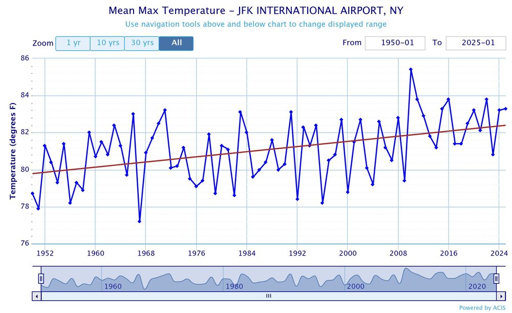
-
Sunday looks humid and 90-92. And 90’+ next weekend . And Stein
-
Looks like COC is going to win out in the 10 days starting Monday. It does feel like a bit of a seasonal shift with the cP airmasses trying to make more latitudinal gain southward. Days still look warm, but dews will be down again.
-
Never mind the back-and-forth, I'm just thoroughly tired of the 70+ dewpoints, which according to the AFD won't be decreased by the upcoming "cold" fronts. Can't wait for the cooling trend.
-
So many great photos from yesterday. Most photogenic day of the year?
-
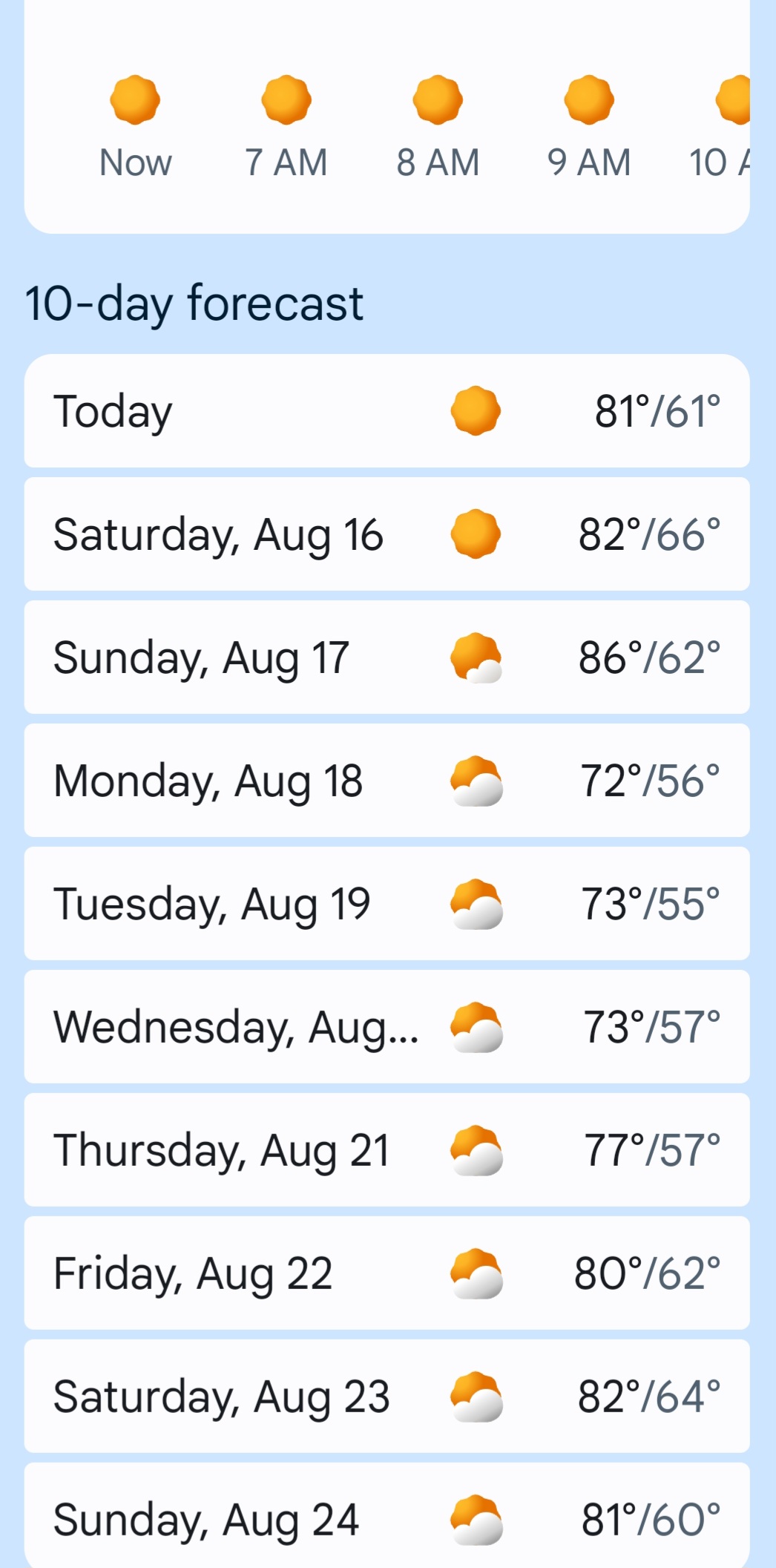
64° / 58° . 10-day forecast looks more than takeable. Best August ever?
- Today
-
Saw that heading my way on radar, looked good, it added another .08" to my weekly total, which is up to .18".
-
Parts of Raleigh had significant flooding AGAIN last night. We were on northern edge but some areas saw up to 3” of rain. Our 0.67” brings the monthly total to 9.06”
-
Been busy... Looks like I got .5 on Wednesday. It dried up in no time Yesterday driving home I found the only rain around. Good thing too because the windshield was covered in bugs and I could hardly see. That stretch between Binghamton and Roscoe is brutal for bugs.
-
In a few month we'll be suffering from an endless wind and cold. I'll (and a few other ones on here) will enjoy of what summer has to offer us.
-
Still 50/50 lad
-

2025 Atlantic Hurricane Season
BarryStantonGBP replied to BarryStantonGBP's topic in Tropical Headquarters
Were you in Georges? -
I had 91 yesterday. Wasn't expecting it to be so warm.
-
Now we're seeing a burst of convection near the apparent center, and this may be particularly well timed should it sustain itself through the diurnal max. We'll see if this leads to TC genesis. Given the structural organization that seemed to be underway this evening, it probably increases the odds. This was a few hours ago before this burst
-
 It hit 91 here today, so we made it a 5 day heat wave. It most likely ends tomorrow but it's going to be close. I think we'll probably stop at 88 here tomorrow, but we have a slight chance to extend the heat wave to 6 days.
 -
We are getting insane rain here right now....after midnight!
-
0Z UKMET shifted a bit E with recurve at 69.6W (vs 71.9W on 12Z) meaning passing by closer to Bermuda: TROPICAL STORM ERIN ANALYSED POSITION : 17.1N 51.9W ATCF IDENTIFIER : AL052025 LEAD CENTRAL MAXIMUM WIND VERIFYING TIME TIME POSITION PRESSURE (MB) SPEED (KNOTS) -------------- ---- -------- ------------- ------------- 0000UTC 15.08.2025 0 17.1N 51.9W 1004 34 1200UTC 15.08.2025 12 18.0N 55.1W 1003 37 0000UTC 16.08.2025 24 19.5N 58.1W 1001 39 1200UTC 16.08.2025 36 20.3N 61.6W 999 41 0000UTC 17.08.2025 48 20.8N 64.4W 996 40 1200UTC 17.08.2025 60 21.4N 66.5W 992 46 0000UTC 18.08.2025 72 22.5N 67.7W 989 48 1200UTC 18.08.2025 84 24.1N 68.7W 987 50 0000UTC 19.08.2025 96 25.9N 69.2W 985 52 1200UTC 19.08.2025 108 27.5N 69.4W 983 57 0000UTC 20.08.2025 120 29.4N 69.6W 979 60 1200UTC 20.08.2025 132 31.7N 68.7W 971 64 0000UTC 21.08.2025 144 33.8N 67.2W 964 70 1200UTC 21.08.2025 156 35.8N 64.0W 960 73 0000UTC 22.08.2025 168 37.6N 59.0W 954 75
-
We need to talk about the snow....that 10 years were in insane! I am taking minimum 6 inches...max 12 inches. It was the entire decade!!


.png.e9e652dedfc32221d2ad9cf890872294.png)