All Activity
- Past hour
-

“Cory’s in NYC! Let’s HECS!” Feb. 22-24 Disco
Ginx snewx replied to TheSnowman's topic in New England
Rap da da Rap they call me the Rapper
-
Why is there so much whining in the main thread? Literally nothing has happened yet!
-
For reference…
-
Weenie flakes here. Won’t pick up additional accumulation but it’s been off and on all day.
-
How am I getting carried away?
-
Now, that's NJ....
-
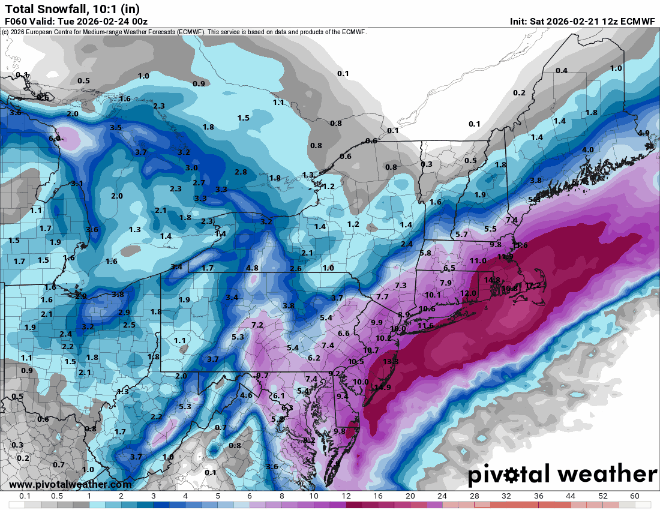
EPS ensembles keeping a slightly further west cluster compared to 12z based off MSLP. Looks to reduce far eastern outliers as well. Don’t have precip output
-
Yeah I know. Imby sport of course...
-
Who is ready to wake up to heavy rain tomorrow?
-
BITCHIN’ nachos, man.
-
We need to take advantage of the clear skies for temps and avoid LWX suddenly upgrading us to a warning before the event as that’s usually the kiss of death.
-

2/22-23 "There's no way..." Storm Part 2
Kevin Reilly replied to Maestrobjwa's topic in Mid Atlantic
Yes Euro Gfs Canadian and UK type models at this lead will smooth things out. What is happening upstairs at 500 is all that matters. Now we move towards to dynamic models to track banding, temps crashing from aloft, and thundersnow. Quite frankly we are about done looking at Gfs Euro Icon Uk Candian models. The tracking is about to come to an end time to watch the water vapor map radar. -
it’s a huge improvement for me and a bunch of other people though.
-
This was a 2010 Boxing Day type victory for the GFS
-
Nam will calm down tonight or show 4 feet. Either is on the table
-

“Cory’s in NYC! Let’s HECS!” Feb. 22-24 Disco
H2Otown_WX replied to TheSnowman's topic in New England
My all time greatest melt -
This seemed like mostly noise to me. The precip field in general shifted northwest albeit slightly but the slug of moisture wasn’t as apparent towards PHI
-
Really not much more to say, we are in for a top 10 storm. Hard to believe the blizzard warning currently as it was close to 50 today
-
Why is it bad to talk about? Just wondering
-
This is why I'm losing what middling enthusiasm I had for this. I don't care how tucked it is--if the coastal moisture isn't getting here I'm not interested because the norlun thing is for the elevations. 4" slop is not exciting.
-

“Cory’s in NYC! Let’s HECS!” Feb. 22-24 Disco
ORH_wxman replied to TheSnowman's topic in New England
yeah seems a little light. You want to include some realistic upper bound in there like 18-20”….obviously it could be higher too but at least go up to the 75% range. -
Got some beer and an interesting cheap bottle of Bourbon, gotta get a mixer tomorrow. I haven't started the generator in way too long and only have some old gas so I guess I should get a new gas can, fresh gas and a can of starter fluid.
-
-
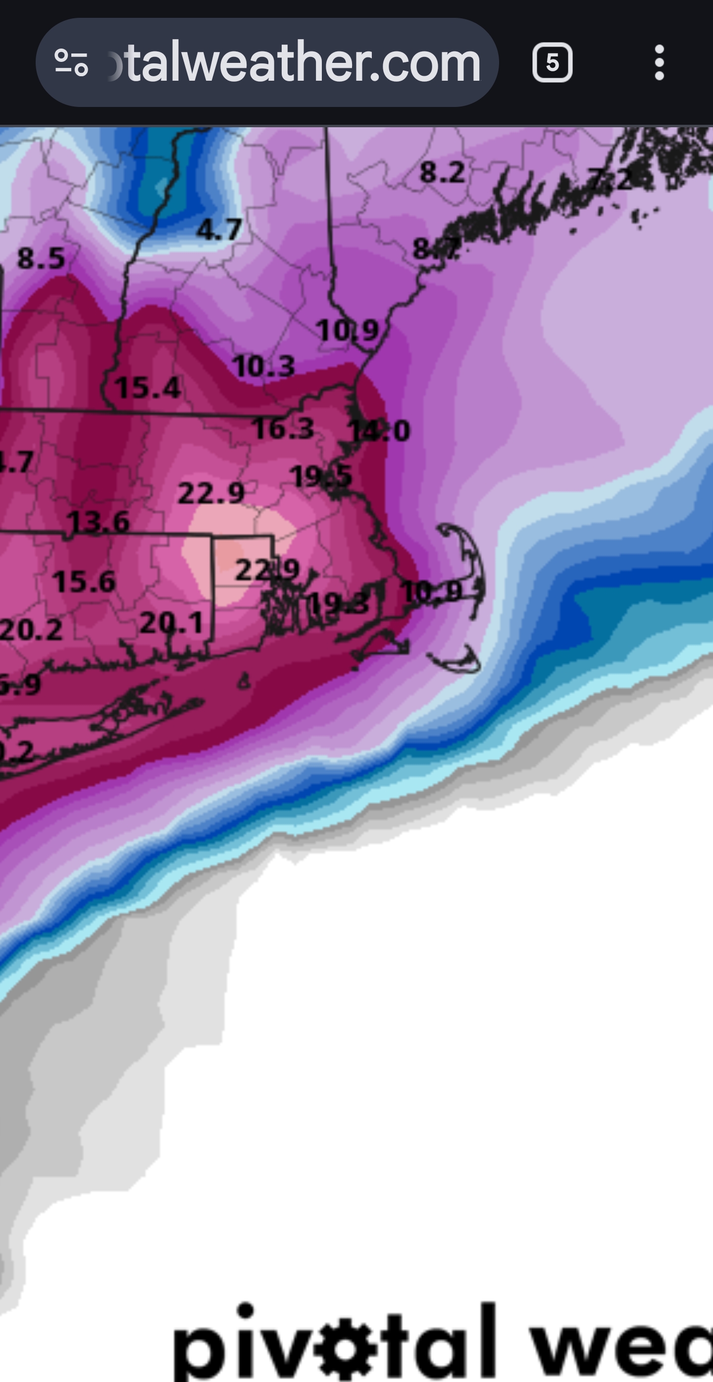
 25+? No. 20+? Yes. I'm thinking this storm is more west than east. I think that with how explosive it will be, will give 2-3 inch per hour snowfalls under some really awesome deathbands. I think from 8 pm - 8 am is our window. Say we get a few inches before that and a few inches after that. I think this breaks records.
 -
https://x.com/cryptogeek101/status/2025355930049597947?s=46 poll on central park accumulations