All Activity
- Past hour
-
While I agree greatly about the fact that temperatures have been a key driver of this stretch, I will push back slightly on the no big storms for the mountains. Maybe I'm thinking more in terms of cycles, but we've had at least two 20"+ "cycles" over say a 2-3 day period. I do think the upper elevations of 3,000ft+ are wearing the brunt of the positive snowfall departures over the valleys too. Often we see in synoptic seasons like 2007-2008, the valley locations under 1,000ft can see just as much snow as the mountains... because it's synoptic forcing up at 700mb and above. You get a 1" QPF dump and it hits at 300ft almost the same as at 3,000ft if the temperatures are cold enough. But this stretch has been meso-scale driven and just loaded QPF and snowfall into the upper elevations non-stop. And a bunch of the early snows in November were heavy QPF events. It was elevational driven too... like when Stowe opened with 250 acres of terrain all on natural snow essentially back in mid-November, my backyard had next to nothing. There was a monster gradient in there for 2-3 weeks around 1,500ft. From like 1-3" to like 18"+. Which I think is seen in some of the lower elevation snowfall numbers as to why they aren't as ahead of normal as some other years... while the mountains are clearly in record territory. I do agree on the bread and butter though... despite a couple of "big events" they aren't hyped events. I think there was one Winter Storm Warning? Even Advisories have been limited for this, largely because the snow has been impacting higher elevation spots and been mesoscale in nature. The Stowe Snow Report team ran a SWE analysis yesterday for NWS/NOAA and I'll share some photos later, but we generally found 55" depth at 3,000ft High Road with 13" of water. While 1,500ft was 26" snow depth and 6" of water. 13" of water up high seemed fairly impressive for a snowpack that began roughly 6 weeks ago. That's a good slug of frozen QPF! And would check out for over 100" of snowfall.
-
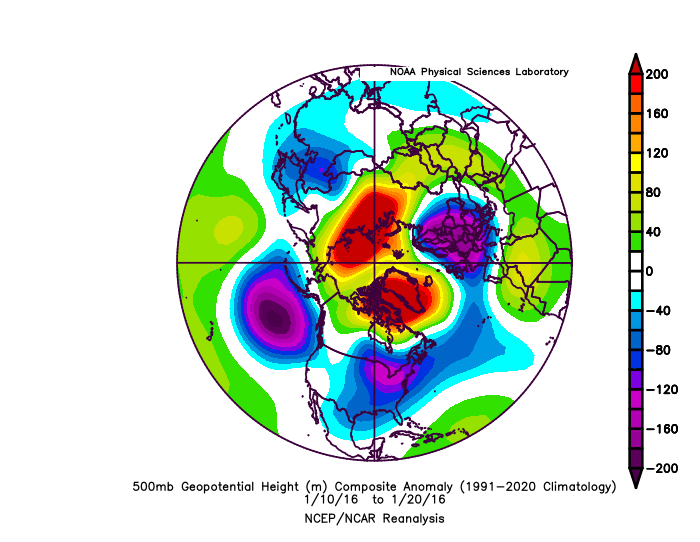
ehh, 2016 was not luck. there was a very strong west-based -NAO that developed, which is a classic KU signal
-
Yep, h5 pattern seems to be trying for some light to moderate events for MA-NE. Maybe a 96-like big dog can happen, but extremely unlikely.
-
I'm becoming more convinced over the years that snow around here is completely random luck that can happen any winter. 2016 was a warm turd except for the week prior to the storm and another short period of cold around valentines day.
-

2025-2026 Fall/Winter Mountain Thread
Maggie Valley Steve replied to Buckethead's topic in Southeastern States
I just hit 60 for the first time in a month! It feels great too! -
95-96 was a Niña
-

December 2025 regional war/obs/disco thread
weatherwiz replied to Torch Tiger's topic in New England
I hope its 85F on April 17 so I can watch playoff hockey outside with just a jersey on -

December 2025 regional war/obs/disco thread
40/70 Benchmark replied to Torch Tiger's topic in New England
2032. -

December 2025 regional war/obs/disco thread
weathafella replied to Torch Tiger's topic in New England
Winter finally ends April 17th… -
December 2025 regional war/obs/disco thread
weatherwiz replied to Torch Tiger's topic in New England
My recommendation for those people then would be to move to the Sierra's or Cascades lol. I mean if we're active with 3-4" events and people are still complaining then something is wrong. Surely we all want the big storm but there has to be some sort of realistic expectation too. -

December 2025 regional war/obs/disco thread
Torch Tiger replied to Torch Tiger's topic in New England
4 months? Lol -
most will be gone by the time we see the first drops of rain-tomorrow looks sunny and 50-55
-
Lets go nuts and have Boxing Day II
-
December 2025 regional war/obs/disco thread
40/70 Benchmark replied to Torch Tiger's topic in New England
I would take that in a heartbeat. I'm not nearly as greedy in the lead up to Christmas...in January you can F right off with that. -

December 2025 regional war/obs/disco thread
Kitz Craver replied to Torch Tiger's topic in New England
I love a high frequency of smaller events. Pack sustained and always looking fresh -
Hit 50.6 degrees briefly about noon here, first time above 50 since 11/27. Was a high haze/cloud cover, now lowered clouds, looks like rain soon? although with an 21 degree DP it'll be virga. Temp down to 47.8 degrees at 1:30 pm.
-
sir, this is a La Nina
-
December 2025 regional war/obs/disco thread
40/70 Benchmark replied to Torch Tiger's topic in New England
Absolutely. -
I doubt it would. It isn't about hitting climo averages. I think most would sign for a 3 footer and then spring. I'd sign for 1" a day for the next 4 mos myself.
-
December 2025 regional war/obs/disco thread
40/70 Benchmark replied to Torch Tiger's topic in New England
No, I agree a low first half of a season correlates with a low season in general...what I am saying is that a very low December is a much more dire signal in a cool ENSO season than in a warm ENSO. Side note...that response sounded more abrasive than I intended...wasn't trying to be a dick. -
Temp is up to 46 here -- the mildest day in quite awhile. But the last couple days really felt like deep winter with 6 inches of snow on the ground and frigid temps. It was a real treat for winter lovers to have that situation in mid December. Now though the snow is melting quickly.
-
December 2025 regional war/obs/disco thread
weatherwiz replied to Torch Tiger's topic in New England
I could see a marginal get thrown up for far eastern CT/RI/SE MA. the NAM would certainly argue it but sometimes the NAM gets a little overzealous with elevated in stability in these setups. NAM does have a pocket of steeper mid-level lapse rates (and greater CAPE) but I think its overdone in that regard. The key for eastern areas will be little to no shower activity ahead of the main area -
We need blocking. These NS waves are cute for a day or two, but this area needs a region-wide snowstorm with overrunning moisture from the south on top of a slow moving, dense dome of arctic air blocked by a downstream traffic jam.
-

December 2025 regional war/obs/disco thread
Typhoon Tip replied to Torch Tiger's topic in New England
I bet a marginal goes up for us on Friday... wouldn't be shocked. -
December 2025 regional war/obs/disco thread
weatherwiz replied to Torch Tiger's topic in New England
Yeah I agree, I definitely would like to start getting some bigger systems, but if we can pull off a good two week stretch where we get 3-4 systems in the 2-4" range...I would hope that makes everyone a bit happier lol.


