All Activity
- Past hour
-

Augdewst 2026: Summer's Last Stand
HIPPYVALLEY replied to Prismshine Productions's topic in New England
Greenfield has had 7”+ the past 10 days. Weird precip distro this year. -
Almost seems like an aspect of a more monsoonal type climate when the highest annual temperatures occur earlier before the heavier rains arrive.
-

Augdewst 2026: Summer's Last Stand
Cyclone-68 replied to Prismshine Productions's topic in New England
It’s easier to cheer for other people’s good fortune after you’ve had at least a taste -
(002).thumb.png.6e3d9d46bca5fe41aab7a74871dd8af8.png)
Central PA Summer 2026 Discussion/Obs Thread
ChescoWx replied to Voyager's topic in Upstate New York/Pennsylvania
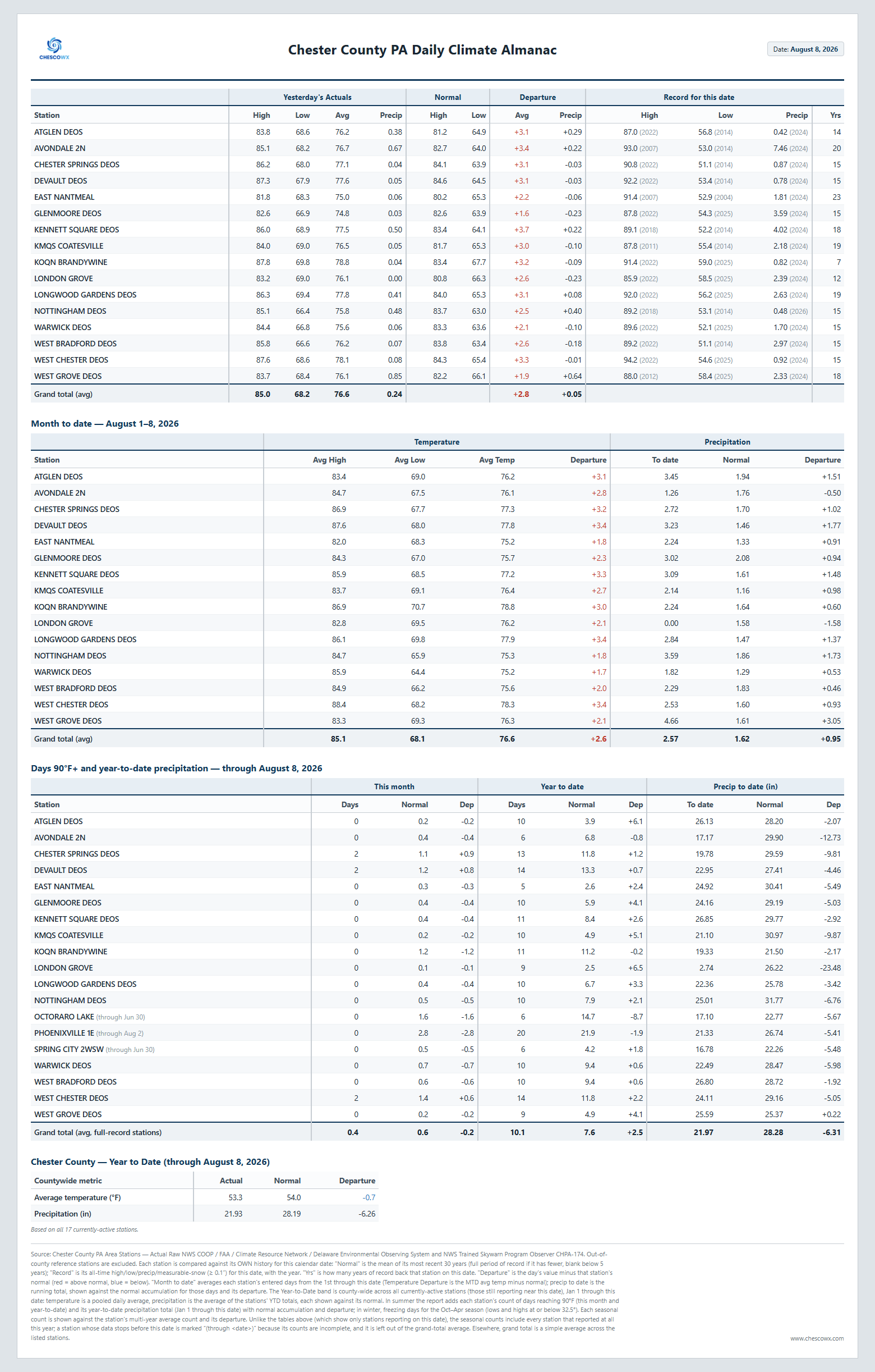
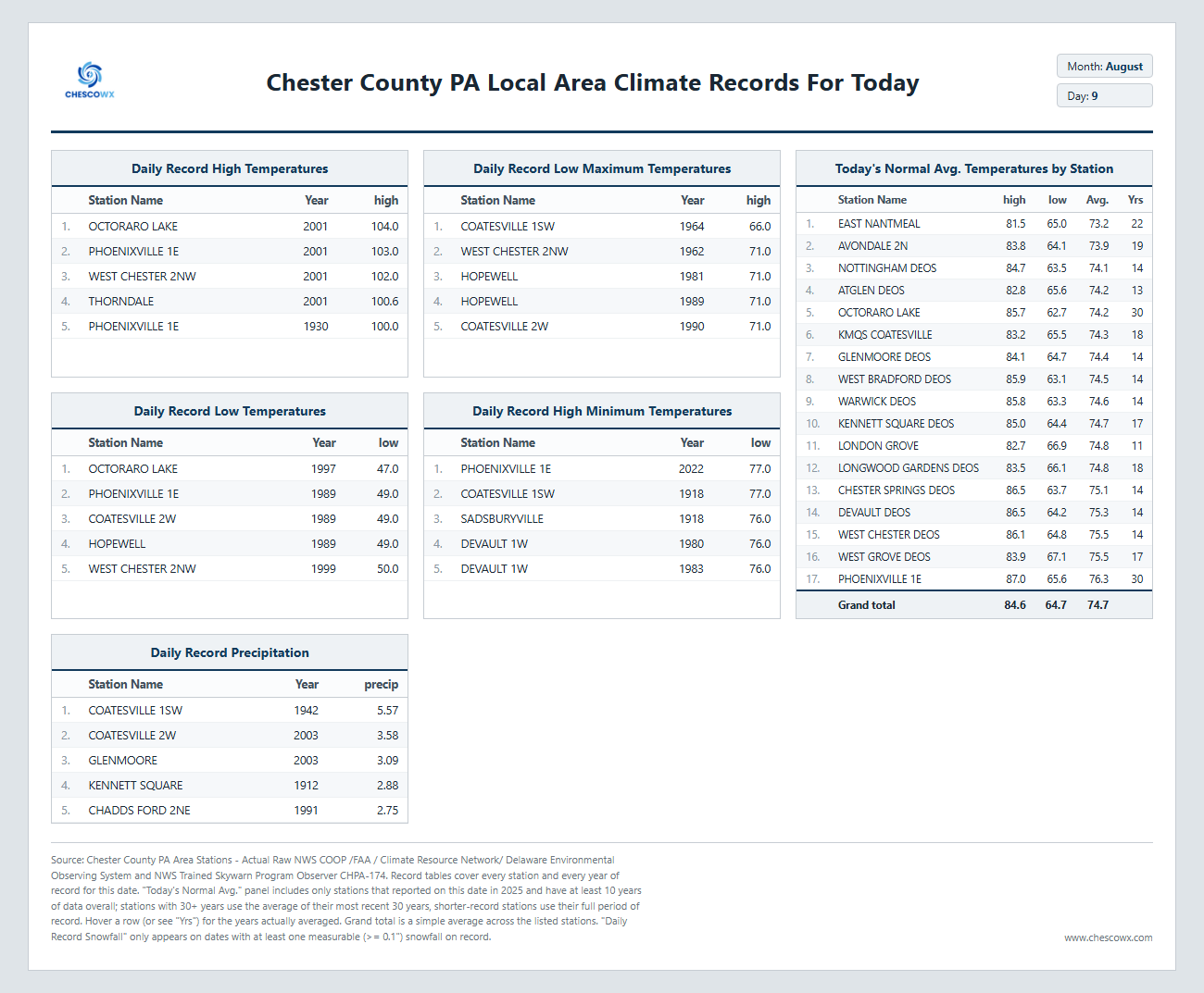
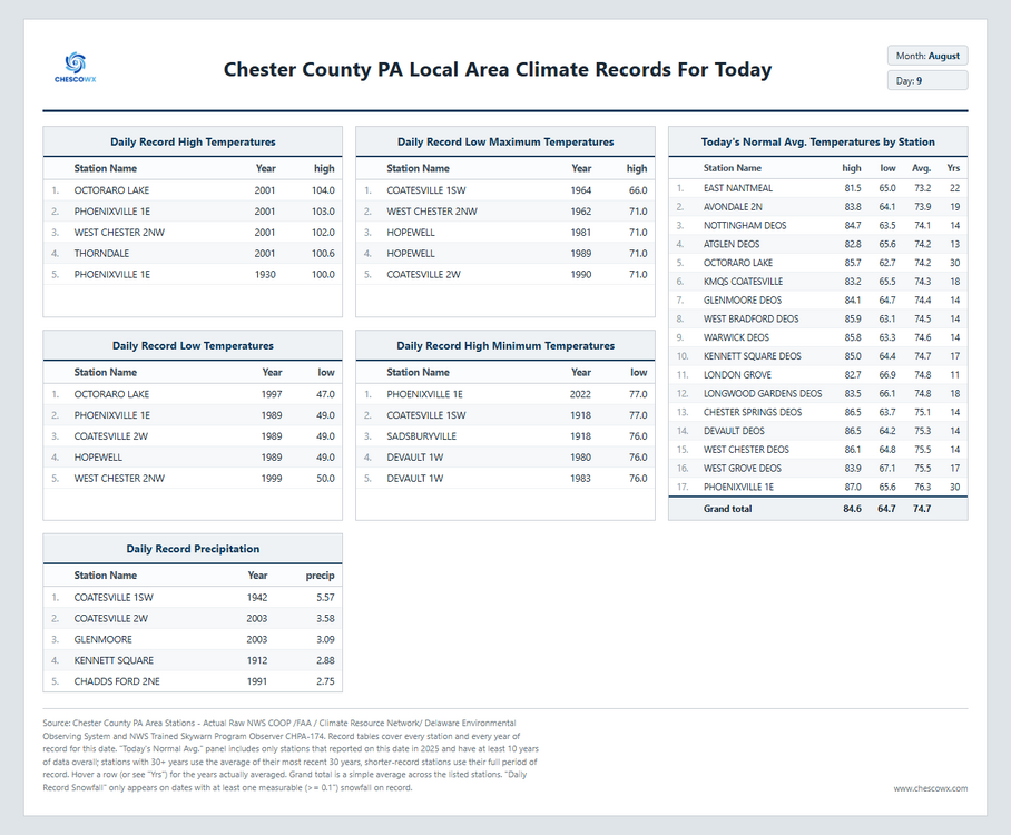
Continued warm and humid through Tuesday before we start a welcome cooling trend which by Saturday morning will see some locations with lows in the 50's with highs by the end of the week in the pleasant 70's. Best chances of any rain will be Monday night through Wednesday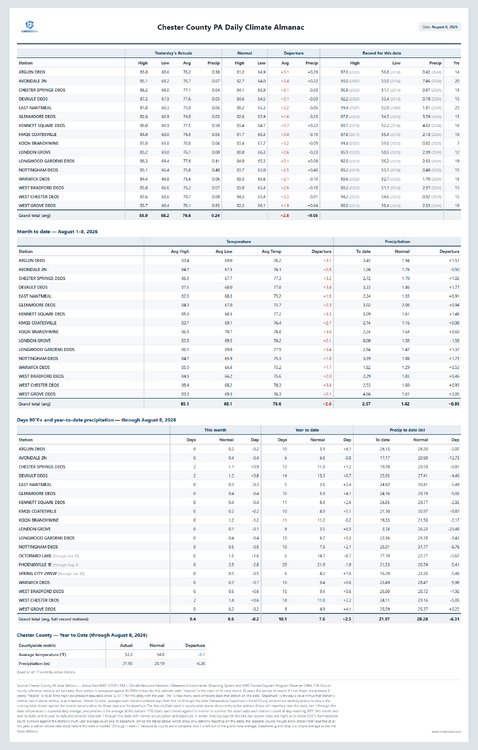
-
E PA/NJ/DE Summer 2026 Obs/Discussion
ChescoWx replied to PhiEaglesfan712's topic in Philadelphia Region
Continued warm and humid through Tuesday before we start a welcome cooling trend which by Saturday morning will see some locations with lows in the 50's with highs by the end of the week in the pleasant 70's. Best chances of any rain will be Monday night through Wednesday
-

2026 Atlantic Hurricane Season
vortex95 replied to Stormchaserchuck1's topic in Tropical Headquarters
"Atmosphere accomplishment?" Great term! Alliteration to boot! Last year, all the hurricanes except Melissa got strong and peaked in intensity outside the deep tropics (N of ~20N). Even Melissa struggled w/ shear for 4 days before getting its act together. And in 2024, the same thing occurred basically (Beryl the only classic MDR system). The MDR has had some issues in recent years, even when the overall pattern has been quite favorable for an active season. And besides Beryl, no long-tracked, classic Cabo Verde hurricanes in 2024 or 2025. When I say "classic Cabo Verde", I am talking something like Isabel from 2003 or Ivan from 2004. -
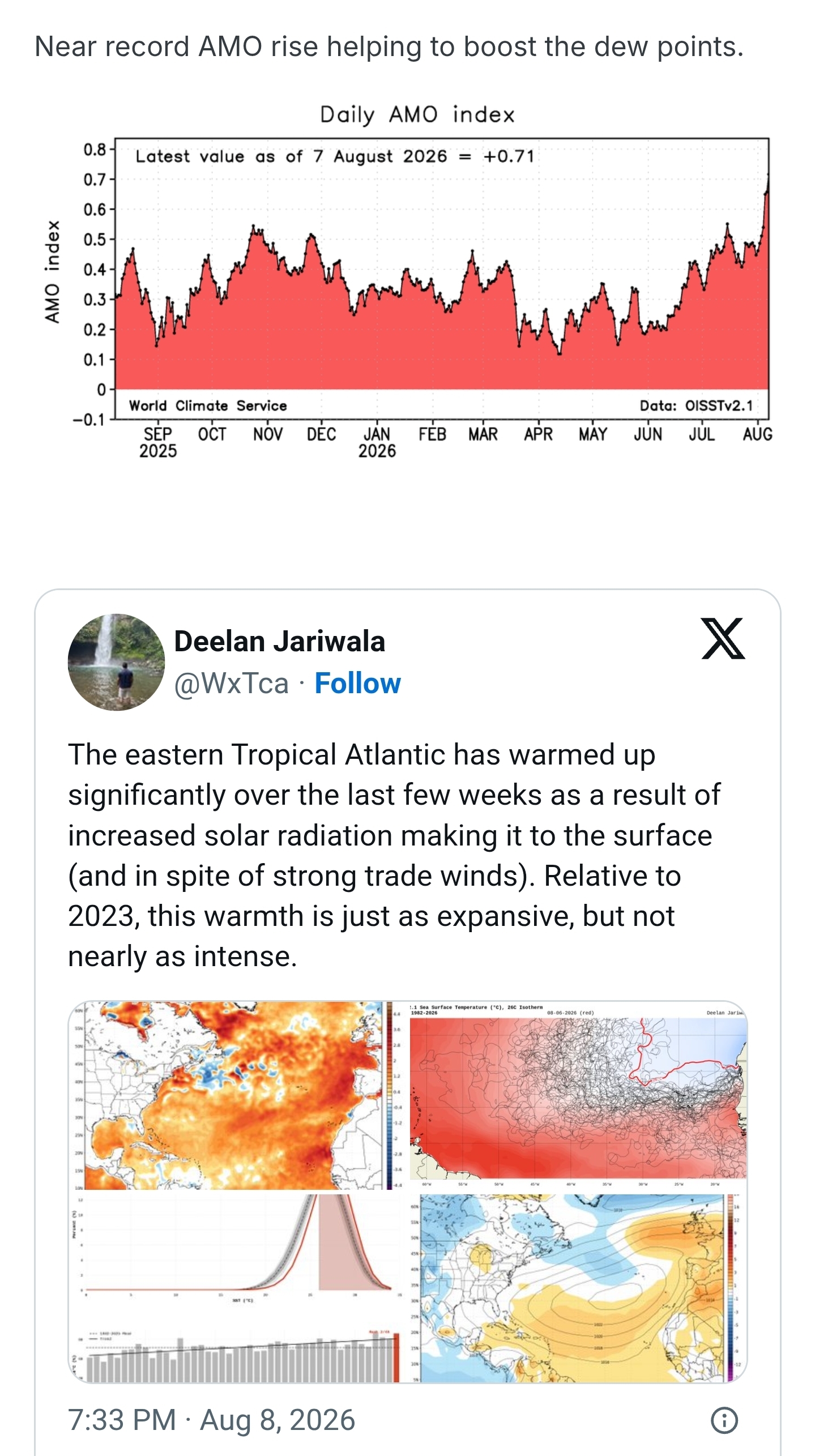
i wonder if it's because of increasing moisture
-
Augdewst 2026: Summer's Last Stand
vortex95 replied to Prismshine Productions's topic in New England
As opposed to what, *unnatural* rainfall? LOL. What narrow-minded curmudgeon weenie! We could get another 7/10/1989, and you'd still be like MEH! -

Central PA Summer 2026 Discussion/Obs Thread
mahantango#1 replied to Voyager's topic in Upstate New York/Pennsylvania
zero rain yesterday except for a few drops. -
I'm glad someone cashed in. Another day or near misses for me. That's been the story of the summer except for about a week stretch in July. With the looks of the coming Nino, we'll probably all tire of rain this winter. We'll see I guess.
-
Notable near miss 2021 8/12: 98 , 8/13 : 99 also 2016 8/13: 99 , 8/14: 98
-
-
Records: Highs: EWR: 105 (2001) NYC: 103 (2001) LGA: 104 (2001) JFK: 98 (2001) Lows: EWR: 58 (1944) NYC: 57 (1989) LGA: 61 (1962) JFK: 57 (1989) Historical: 1878 - The second most deadly tornado in New England history struck Wallingford CT killing 34 persons, injuring 100 others, and completely destroying thirty homes. The tornado started as a waterspout over a dam on the Quinnipiac River. It was 400 to 600 feet wide, and had a short path length of two miles. (The Weather Channel) 1918: One of the worst hot spells on record occurred in Washington, DC with an average high 99.6°F from 5th to 9th, 106° on 6th. (Ref. Washington Weather Records - KDCA) 1930: The temperature at Perryville, TN reached 113 °F to establish a state maximum temperature record for Tennessee. (Ref. Lowest and Highest Temperatures for the 50 States) 1959: The Richmond International Airport wasn't affected by this storm. It was the west end of Henrico County, VA that received the heavy rain causing flash flooding. The following reference has several pages of information about this storm. (Ref. Daily News Record Newspaper - Harrisonburg, Virginia) 1963: A severe thunderstorm with extremely strong winds struck Stillwater, OK during the night. At Stillwater Municipal Airport, wind speeds were measured between 92 and 115 mph for eight consecutive minutes, with a peak gust reaching 138 mph. The storm did an incredible amount of damage, especially to the Oklahoma State University campus. Winds caused widespread roof and tree damage, and broke windows out of about 130 automobiles. (Ref. Wilson Wx. History) 1969 - A tornado hit Cincinnati OH killing four persons and causing fifteen million dollars property damage. The tornado moved in a southeasterly direction at 40 to 50 mph. (The Weather Channel) 1974: New Jersey--One person was killed when struck by lightning at a rock concert at Atlantic City Race Course. (Ref. Lightning-The Underrated Killer.pdf) 1976: Hurricane Belle formed just to the northwest of the Bahamas on the 6th, rapidly intensified to a Category 3 southeast of North Carolina. Hurricane Belle then began to weaken, moving into western Long Island near Jones Beach as a minimal hurricane during the evening on this date. Hurricane warnings were extended to the coastal sections of New Jersey, New York, Connecticut and Rhode Island where tides as high as 12 to 15 feet were expected. New York City measured a gust to 56 mph. Philadelphia, PA reported 0.51 inches of rain on the 8th, with an additional 1.17 inches on this date. The tide reached 8.8 feet above mean lower low water at Atlantic City, NJ, tying the level reached during the great coastal storm of 3/6/1962, and again reached during the "Perfect Storm" of 10/31/1991. Severe coastal flooding begins at 8.7 feet. (Ref. AccWeather Weather History) 1979: Major flooding occurred on the Lost Creek in West Virginia. Water up to 7 feet deep flooded the town of Clarksburg. (Ref. AccWeather Weather History) 1980: Severe lightning occurred across West Virginia. Two people were struck on a golf course near Vienna, WV. A person standing between the two victims was uninjured. 12 people were injured when lightning struck during a prayer service near Bluefield, WV. Hurricane Allen threatened the Texas coast. Air Force reconnaissance measured a very low central pressure of 909 millibars or 26.84 inches of mercury just in the very early morning hours with maximum sustained winds near 180 mph. (Ref. AccWeather Weather History) 1981: The current all-time record maximum temperature for Portland, OR is now 107 °F set on this date (Extreme Weather p. 276, by Christopher C. Burt) 1987 - Florida baked in the summer heat. Nine cities reported record high temperatures for the date, including Jacksonville with a reading of 101 degrees. Miami FL reported a record high of 98 degrees. (The National Weather Summary) 1988 - Tropical Storm Beryl deluged Biloxi with 6.32 inches of rain in 24 hours, and in three days drenched Pascagoula MS with 15.85 inches of rain. Afternoon and evening thunderstorms produced severe weather in the Southern Plains Region and over the Central High Plains Region. Thunderstorms in Oklahoma producedwind gusts to 92 mph at Harrah. (The National Weather Summary) (Storm Data) 1989 - Evening thunderstorms in Arizona deluged Yuma with record torrential rains for the second time in two weeks. The rainfall total of 5.25 inches at the Yuma Quartermaster Depot established a state 24 hour record, and was nearly double the normal annual rainfall. Some of the homes were left with four feet of water in them. Seventy-six cities in the south central and eastern U.S. reported record low temperatures for the date. Lake Charles LA equalled their record for August with a low of 61 degrees. Canaan Valley WV was the cold spot in the nation with a low of 32 degrees. (The National Weather Summary) (Storm Data) 1992 - A tornado packing winds estimated between 113 and 157 mph caused significant damage to the town of Chester, South Dakota. Shortly after 7 pm CDT a tornado tore right through the heart of Chester causing considerable damage. Four businesses were destroyed, three others had significant damage, and five had minor damage. An elevator and new grain bin were leveled, and another bin was heavily damaged. Most of the building housing the fire department was demolished. Also, many houses and vehicles sustained damage, and large trees were uprooted or broken off. In one instance a steel beam was thrust through a garage and into the car inside. One mile north of Chester, an entire house was moved off the foundation. The town had to be evacuated for 19 hours after the tornado because the tornado damaged a 12,000-gallon ammonia tank releasing 4,000 gallons of the liquid gas into the air. The ammonia was a health hazard forcing residents out. To the south of Chester, the storm destroyed a new convenience store and blew two fuel tanks over 100 yards. 1997: Severe thunderstorms with very heavy rain began over central Mohave County around 12:30 AM and ended around 2:30 AM MST. Washes rapidly filled in the vicinity of Kingman and several roads were washed out. At least two cars were caught in a flooded wash and their four occupants had to be rescued by helicopter. Also, one woman was found dead hours later in a sewer drainage pond. It is unknown how she was caught in the flood waters. Another serious result occurred a few hours after the storms ended when a passenger train derailed while crossing a small bridge damaged and weakened by flood waters. Of the 302 passengers and crew members aboard, 116 were injured and of those eight sustained serious injuries. Further north, severe thunderstorms rolled across the western part of Las Vegas, NV producing damaging winds and hail. A trailer was destroyed and signs and roofs in the area received damage from both the wind and hail. 19,000 homes lost power for a few hours. The storms also produced local street flooding with rainfall amounts up to 0.73 inches in 15 minutes. (Ref. Wilson Wx. History) 2001: In New York, the temperature reached a record 103 degrees for the date while in neighboring Newark, N.J., it topped 105 degrees, the National Weather Service said. The old record in both cities was 100, set in 1949. Electricity demand was so high that lights flickered in New York when the metropolitan area suffered scattered outages. New York Gov. George Pataki ordered parking and admission fees waived at parks statewide. In New York City, municipal pools stayed open until 8 p.m. Mayor Rudolph W. Giuliani called on supervisors of city employees to use common sense in delegating responsibilities, saying that “strenuous work is not suggested at this time, unless it’s an absolute emergency.” In Boston, as temperatures approached a record 99, residents and tourists flocked to malls, museums, movie theaters or any place with air-conditioning. 2002: Washington, DC hits 98° and recorded their 8th consecutive day of 95 °F or higher, the longest such streak in recorded history at this time. (Ref. Wilson Wx. History) 2005: In Eau Claire, WI, a man was struck by lightning while unhooking a chain from a truck. He was taken to a hospital for observation because of “feeling hot,” but otherwise was unhurt. (Weather Guide Calendar with Phenomenal Weather Events 2011 Accord Pub. 2010, USA) 2016: August 9-16. Weak low pressure combined with abundant Gulf moisture produced phenomenal rainfall and flooding across central Louisiana, inundating entire neighborhoods and towns, especially around Lafayette and Baton Rouge. Rainfall totals exceeded 20 inches in as little as two days. Thirteen people died and economic costs ranged from $10 to $15 billion. 2020: In the morning of August 9 Tropical Storm Isaias spawned 8 tornadoes in the Northern Neck of Virginia. See the following two pages about this event.
- Today
-
82 / DP 73 looking mainly dry today and mostly sunny perhaps a bit of an overperformer for warm spots. Day 4 of the heatwave for some. Overall warm - hot through THu before cold front / trough builds into the northeast by Friday 8/14 with near / below normal till around 8/17. Ridge builds back east and next warmup and heat potential in the 8/19 - 8/22 or 23 window. Overall looking warmer than normal beyond there and see if any tropical activity can pick up and kick in.
-

Augdewst 2026: Summer's Last Stand
Damage In Tolland replied to Prismshine Productions's topic in New England
I don’t expect to get much severe here. Not like NW / SW CT who are better positioned. But I do expect to get a few tstorms in an active summer. I mean when Groton to Cape Cod report severe and wind damage several times and I can’t even get a t shower ,it’s just bad luck i guess -

Augdewst 2026: Summer's Last Stand
Lava Rock replied to Prismshine Productions's topic in New England
Naples picked up 1.79". It was just pounding. Sent from my SM-S921U using Tapatalk -

Augdewst 2026: Summer's Last Stand
CT Valley Snowman replied to Prismshine Productions's topic in New England
I thought yesterday pretty much performed as expected. Slight risk over central and western areas where there were some warned cells and a few towns got hit hard while most of us did not. It's just not easy to get widespread severe around here. Most of the time, you just need to get lucky. -
Augdewst 2026: Summer's Last Stand
Damage In Tolland replied to Prismshine Productions's topic in New England
I was thinking about the exact precision I have missed storms this summer. Every direction , every surrounding town really. Union area up to Sturbridge multiple times, S and SE of here . Ginx to Se CT. Hartford got crushed Friday night, BDL all summer , all of western and SW CT and Springfield last night. And now Stein drops the Roman helmet to suffocate -

Central PA Summer 2026 Discussion/Obs Thread
Mount Joy Snowman replied to Voyager's topic in Upstate New York/Pennsylvania
Low of 71 with .15” of rain. Been quite a four day stretch here. Today looks like a perfect river day, might have to hit it. -

Augdewst 2026: Summer's Last Stand
CoastalWx replied to Prismshine Productions's topic in New England
He’s here for awhile. The summer of no storms continues. But I’ll take the sun. -
Our 100° days have been occurring earlier than in the past. Spots in NJ had their earliest 100° day back on May 19th-20th. No 100° days after August 10th during the 2020s. We haven’t had a 100° day after August 10th since 2005. Maximum 1-Day Mean Max Temperature for HARRISON, NJ Earliest and Latest in Bold during the 2020s Click column heading to sort ascending, click again to sort descending. 1 106.0 2026-07-03 2 103.0 2026-07-04 - 103.0 2025-06-25 - 103.0 2025-06-24 3 102.0 2025-07-30 - 102.0 2022-07-25 4 101.0 2025-07-31 - 101.0 2024-07-17 - 101.0 2022-08-10 - 101.0 2022-07-24 - 101.0 2021-06-30 5 100.0 2026-07-02 - 100.0 2026-05-20 - 100.0 2025-07-26 - 100.0 2025-06-26 - 100.0 2024-08-02 - 100.0 2024-06-22 - 100.0 2022-07-23 - 100.0 2021-07-01 Time Series Summary for NEWARK LIBERTY INTL AP, NJ 100° days after August 10th Click column heading to sort ascending, click again to sort descending. 1 1953-09-30 5 0 2 1993-09-30 3 0 3 1948-09-30 2 0 - 1944-09-30 2 0 4 2005-09-30 1 0 - 2002-09-30 1 0 - 1973-09-30 1 0 - 1949-09-30 1 0 - 1881-09-30 1 0
-
Well clouds actually thwarted the heatwave. Had hit 93 and 94 but only 89 yesterday so have to restart today and hope Tuesday can complete the deal
-
 https://sildoliko.shop/# Order Viagra 50 mg online
 -
sildenafil over the counter Cheap Viagra 100mg - buy Viagra online
-
Augdewst 2026: Summer's Last Stand
Damage In Tolland replied to Prismshine Productions's topic in New England
Looks like some smoke up there today.