All Activity
- Past hour
-
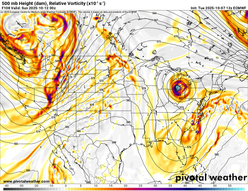
it comes down to whether or not this cutoff energy gets stuck and weakens the ridge
-

Spooky Season (October Disco Thread)
Damage In Tolland replied to Prismshine Productions's topic in New England
Damage? -

2025-2026 ENSO
40/70 Benchmark replied to 40/70 Benchmark's topic in Weather Forecasting and Discussion
latitude -
2025-2026 ENSO
40/70 Benchmark replied to 40/70 Benchmark's topic in Weather Forecasting and Discussion
While I snuck in a good season or two in the earlier stretch, this latter stretch has just been consistently subpar and has avoided reall cellar seasons. The stretch from the 80s into the 90s actually had greater variance in that there were a couple of better seasons, but also a few lower than anything I have seen since 2011-2012. -
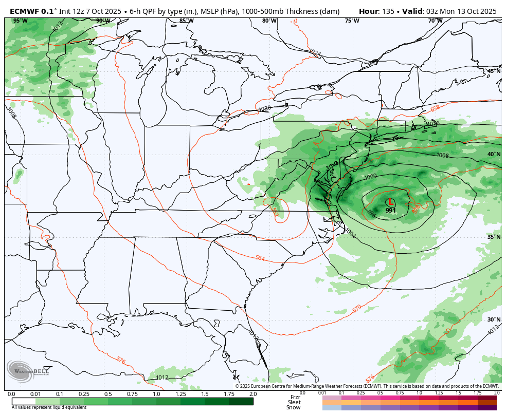
12z Euro is further north with the coastal...looks more like the GFS now
-
Euro's back to showing some rain for Sunday
-

Spooky Season (October Disco Thread)
CoastalWx replied to Prismshine Productions's topic in New England
Euro AI more north too. That is a massive flop from 00z on euro op. -

Spooky Season (October Disco Thread)
tamarack replied to Prismshine Productions's topic in New England
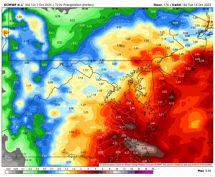
We had 2.64" on Sept 25-26 and the local rivers are nearly back to the levels before that event. Maybe 6" spread over 2-3 weeks would have a significant effect on rivers and groundwater. -
WB 12Z EURO...looks like ICON.

-
Spooky Season (October Disco Thread)
CoastalWx replied to Prismshine Productions's topic in New England
Big move north on Euro. -
Were you not in the mid to upper 80s the last few days?
-
Just goes to show what a little elevation and distance west of the I-95 corridor can do.
-
-
Spooky Season (October Disco Thread)
CoastalWx replied to Prismshine Productions's topic in New England
We GFS? -
2025-2026 ENSO
40/70 Benchmark replied to 40/70 Benchmark's topic in Weather Forecasting and Discussion
Well, it's pretty much noise IMBY...the period from the 1985-1986 through the 1991-1992 seasons averaged 43.3" of snowfall for my area....2018-2019 through 2024-2025 has averaged 41.75". I mean, if that is the impact of CC on snowfall, I can deal. I would prefer the more feast or famine element and won't jump a ledge over 1.5". Less cold and dry, which is the worst IMHO. -
You're in the northwest suburbs. Here next to Manhattan that would be ludicrous with all the 70 degree uhi nights.
-
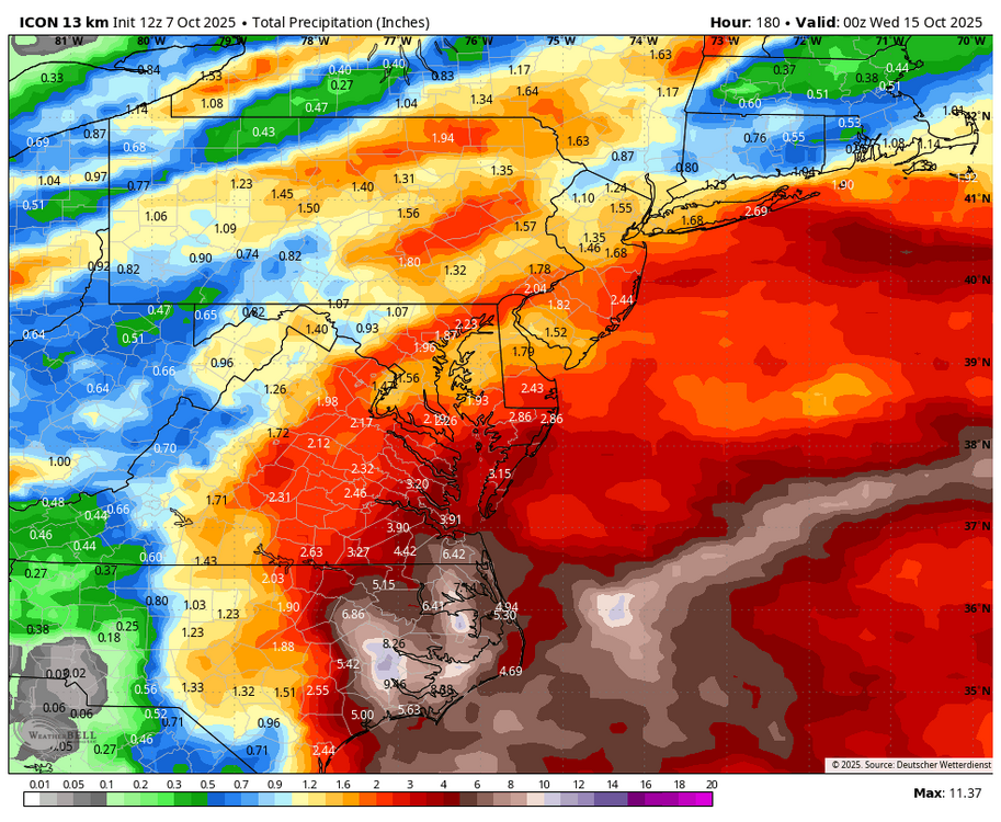
I'm hugging the ICON for the upcoming storm. It nailed the track of the last coastal. (WB 12Z: about .25 is for Wed.)
-
Euro almost completely skunks Baltimore and a stripe of central MD to NoVA
-
depends where you are and how you radiate at night...had a few AC nights here but not many since then
-
That’s definitely not my intention. It’s just that this new and larger temperature jump in 2023-2024 is so new. We know that in the 8 year period 2015-2016 to 2022-2023 with the higher baseline temperature the ceiling at Boston was 59.9” and NYC maxed out at 40.9”. So we are all probably just taking educated guesses at to what the new ceiling at these even warmer levels will be. All we know for sure is that the most recent 7 year running average along the I-95 corridor is the lowest on record for the combined station average.
-
Depends on where you live, how your living space is oriented and your comfort level.
-
I mean we haven't run the AC since like mid August. Sleeping with the windows open ever since.
-
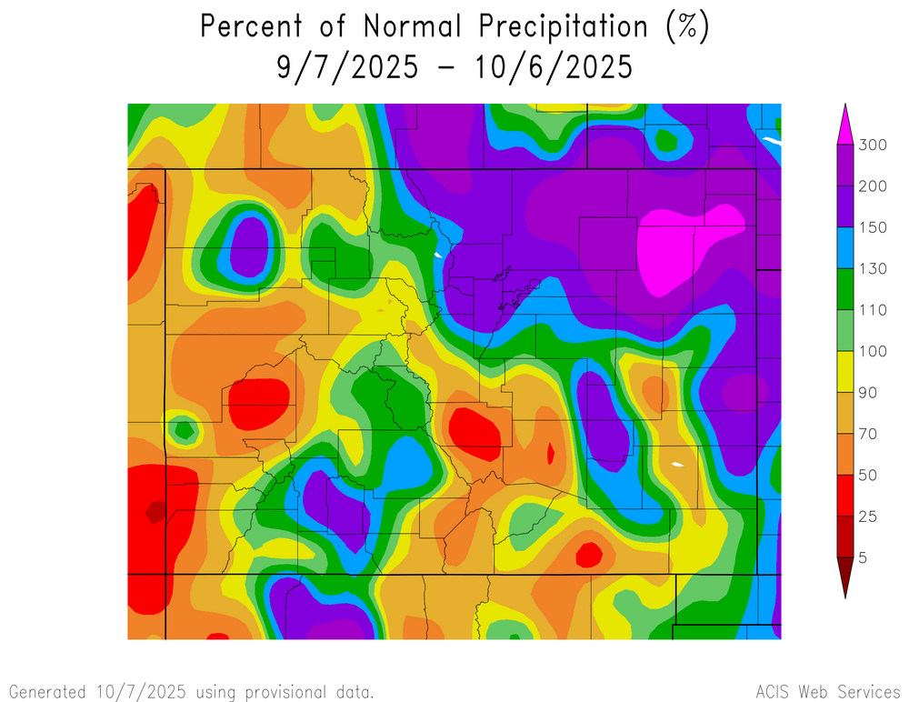
Last hurrays of summer. High just short of 90 yesterday. Today cooler but still upper 70’s. Province is still under severe/exceptional drought conditions. That looks to continue here.
-
to be fair, cansips and cfs are also somewhat dry.