All Activity
- Past hour
-

Another Coating of Snow Saturday - "It's all we Got"
Sey-Mour Snow replied to Sey-Mour Snow's topic in New England
Snow growth looks solid, nice lift in the snow growth zone.. Should be a solid swath of .15-.35" qpf

-
Maybe end of January
-
Another day of model watching. The short range models look pretty good. The GFS is starting to go back and forth, and the Euro is being stubborn. Looks like a classic winter storm threat for NC with not knowing exactly what will happen until it does or doesn't happen.
-
Need to bump to FEB
-
First Legit Storm Potential of the Season Upon Us
Sey-Mour Snow replied to 40/70 Benchmark's topic in New England
made a thread to separate the Saturday and Sunday convo.. -

First Legit Storm Potential of the Season Upon Us
ORH_wxman replied to 40/70 Benchmark's topic in New England
I think you could easily pick up 1-2” provided the QPF is there on Saturday. -
Seems all we can muster up this season are these coating to 2" storms. Higher elevations favored, should be a a few hour period of moderate snow.. Timing differences with the steadiest snow, GFS is a bit earlier, EURO a bit later.. Looks like a snowy Saturday morning for most, earlier the better for accumulation potential down to the shore..
-

First Legit Storm Potential of the Season Upon Us
Baroclinic Zone replied to 40/70 Benchmark's topic in New England
Glad I got a good nights sleep. 06z runs look tame to nothing. -

First Legit Storm Potential of the Season Upon Us
CoastalWx replied to 40/70 Benchmark's topic in New England
Please send as many pics of the coating. From every angle. Deck, backyard, truck, street view. Whatever you can. -

2025-2026 ENSO
donsutherland1 replied to 40/70 Benchmark's topic in Weather Forecasting and Discussion
The probability that parts of the South, including Birmingham, Atlanta, Athens, and Mobile could see a light snowfall on Sunday has increased on the guidance. Snowfall amounts do not look excessive. This will likely be the major winter weather story this weekend. A shot of Arctic air could follow the snowfall. -

First Legit Storm Potential of the Season Upon Us
kdxken replied to 40/70 Benchmark's topic in New England
-

First Legit Storm Potential of the Season Upon Us
Chrisrotary12 replied to 40/70 Benchmark's topic in New England
Time to bow to the king again? -
First Legit Storm Potential of the Season Upon Us
CoastalWx replied to 40/70 Benchmark's topic in New England
I would -
Bump
-

First Legit Storm Potential of the Season Upon Us
MJO812 replied to 40/70 Benchmark's topic in New England
Maybe being in phase 6 is the deathblow. -

First Legit Storm Potential of the Season Upon Us
Hoth replied to 40/70 Benchmark's topic in New England
So I should hold my tee time on Monday? -

First Legit Storm Potential of the Season Upon Us
The 4 Seasons replied to 40/70 Benchmark's topic in New England
you're in a fine spot for a couple assuming we get a good band over CT but i can see it sucking for most of the state at low elevations with just white rain. -

First Legit Storm Potential of the Season Upon Us
Masswx replied to 40/70 Benchmark's topic in New England
Nada storm here maybe in 1-2 weeks -

First Legit Storm Potential of the Season Upon Us
UnitedWx replied to 40/70 Benchmark's topic in New England
You're learning! But.. I'll be in Westfield this weekend -

E PA/NJ/DE Winter 2025-26 Obs/Discussion
Mikeymac5306 replied to LVblizzard's topic in Philadelphia Region
At this point, The GFS is nothing but a fun fantasy model to look at if you are jonesing for any type of particular inclement weather. Very hard to rely on when it's the only model showing something. Had flakes flying on the way into work this morning. -

First Legit Storm Potential of the Season Upon Us
Damage In Tolland replied to 40/70 Benchmark's topic in New England
Just can’t allow any snow here even when it’s obvious . Ok you’re right no snow Saturday here. None . Zero . Zippo, zilch -
First Legit Storm Potential of the Season Upon Us
kdxken replied to 40/70 Benchmark's topic in New England
So what's the consensus as of now? An inch or two on Saturday and the same late Sunday / Monday? -
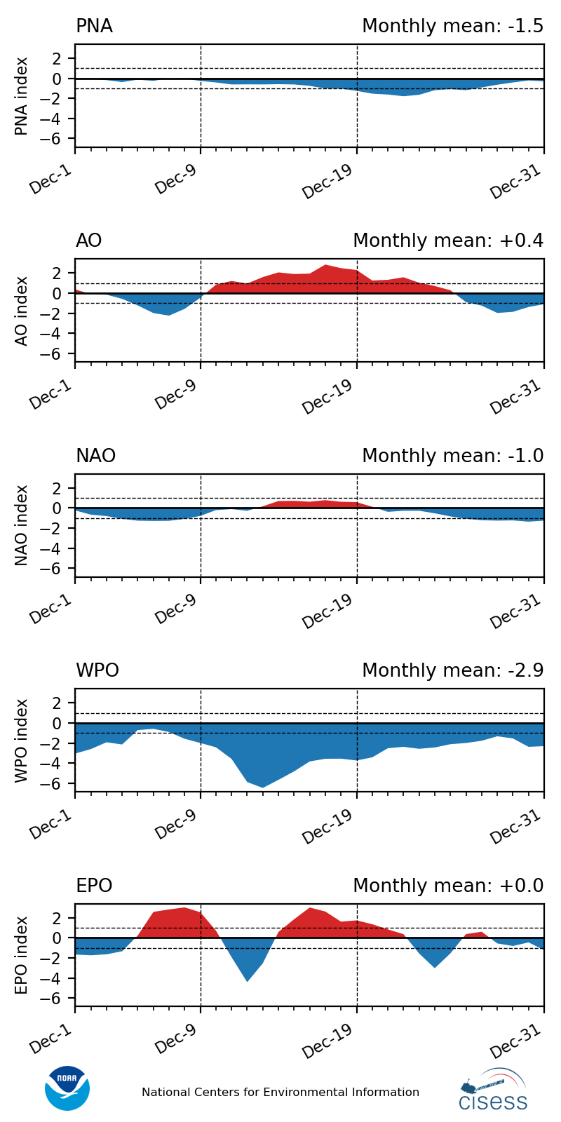
The Euro and EPS have done a better job with the Northern Stream this winter than the other guidance. All the Northern Stream kickers have prevented the Southern Stream disturbances from developing into KU heavy benchmark coastal snowstorm tracks. December was a unique case where we were able to get a few moderately snowy clippers tracking to our south. But this month so far we lost the record -WPO which combined with the -NAO for those two favorable tracks.

-
First Legit Storm Potential of the Season Upon Us
CoastalWx replied to 40/70 Benchmark's topic in New England
It’s gone -
The gfs ai went west Also what’s the use of ensembles if they are all wrong