All Activity
- Past hour
-

2025-2026 ENSO
40/70 Benchmark replied to 40/70 Benchmark's topic in Weather Forecasting and Discussion
Given the embryonic nature of this cool ENSO, I'm not sure the -IOD is really going to couple with it enough to be a huge deal....bottom line is I would expect a weak La Nina response...this shouldn't be 2022-2023. -
There will be showers and thunderstorms around Tuesday, could even see an axis of some heavier rain up north (or in the vicinity of the warm front).
-
2025-2026 ENSO
40/70 Benchmark replied to 40/70 Benchmark's topic in Weather Forecasting and Discussion
Looks similar, but I'm a bit more aggressive of some episode(s) of blocking do to the easterly QBO/solar max composite. -
2025-2026 ENSO
40/70 Benchmark replied to 40/70 Benchmark's topic in Weather Forecasting and Discussion

-
the globals have some rain mid week..amounts tbd.
-
2025-2026 ENSO
40/70 Benchmark replied to 40/70 Benchmark's topic in Weather Forecasting and Discussion
The real heart to the drought is over northern New England....couple that with a modest +NAO and maybe its finally my turn. -
Seems like a carbon copy of last fall-rain the weekend after Labor Day then nothing for weeks/months
-
It is, but the convective trend has reversed with shear and dry air decreasing. This is why the models are once again getting bullish on organization and intensification this weekend.
-
Just my opinion but this air mass arrival's the shot across the bow - symbolic hearkening that the next might be more discerned. Probably we recover with at least tepid warmth later next week ... normal after these first 'smells like autumn' marginal froster deals - less marginal across NNE of course.. It's also ( as an aside...) like a 'sub-continental tuck' air mass. It's not really continental in scale. It is just a transient short duration cool shot curling an autumn air mass sneakily through Quebec. Buffalo has no idea it's happening - straight N shot for 24 hours. Altho it may try to cheat radiate one more night before it rolls out. The more canonical sab air mass looks more PNA-ish. It's almost just a reflection of how our geodesic circumstance sucks cold into this specific region ha
-

2025 Atlantic Hurricane Season
Wannabehippie replied to BarryStantonGBP's topic in Tropical Headquarters
Gabrielle is still a naked swirl this AM, with all the convection displaced far from the center of circulation. Center is somewhere to the south and west of that blob of convection. -
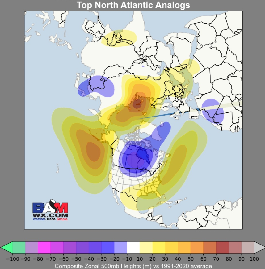
Honestly, the most concerning thing, at least as far as snowfall is the drought. These typically aren’t easy to break, especially when in place for several months. They form a feedback cycle. And parts of the northeast are historically dry As far as the SE ridge, I think we do see much more SE ridging this time around due to the state of the Atlantic. BAMWX actually touched on this yesterday
-
Front is through. A little chill when the sun is behind the clouds. 66/56 but dews will be droppin.
-
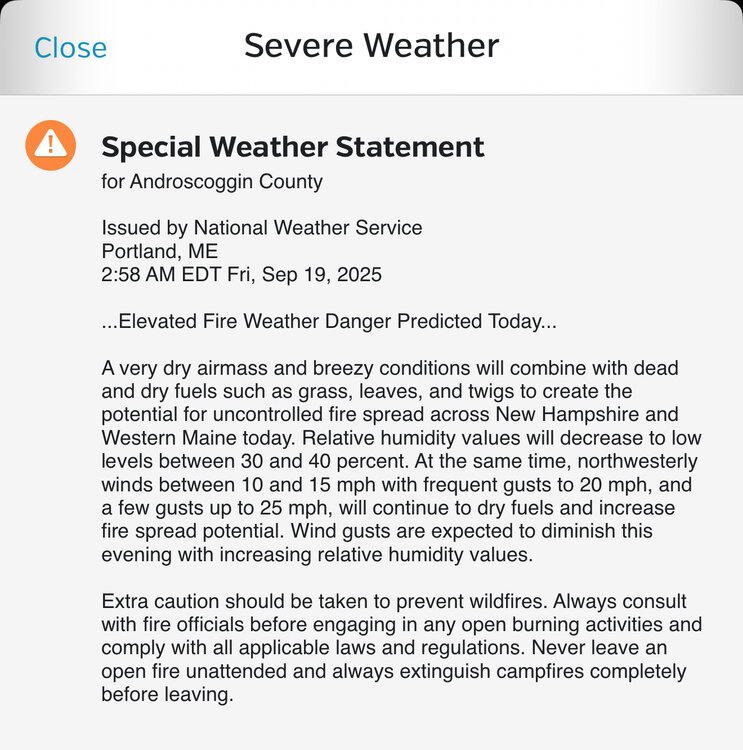
Today could be the day, Burn it all down.
-

September 2025 OBS-Discussion centered NYC subforum
MJO812 replied to wdrag's topic in New York City Metro
Im wearing a tank top today -
Already 74F, looks to be the last 80F+ for a while... maybe even till next year.
-
No rain for another 10-20 days and the entire region will be engulfed
-
Maybe get some brush fires this weekend to liven things up in here?
-
Drought infighting . .. what a time in our lives
-
We've had a few foggy mornings here the last 2 weeks.
- Today
-
Through the first 8 complete months of 2025 the average temperature across Chester County has been 55.3 degrees this is the 37th warmest start to a year since records began 133 years ago back in 1893.
-
(002).thumb.png.6e3d9d46bca5fe41aab7a74871dd8af8.png)
E PA/NJ/DE Autumn 2025 Obs/Discussion
ChescoWx replied to PhiEaglesfan712's topic in Philadelphia Region
Through the first 8 complete months of 2025 the average temperature across Chester County has been 55.3 degrees this is the 37th warmest start to a year since records began 133 years ago back in 1893. -

September 2025 OBS-Discussion centered NYC subforum
FPizz replied to wdrag's topic in New York City Metro
What about 40" winters? Just wondering. -
-
69° / 59° . A taste of Summer. Wish I had worn shorts to work.
-
i'm pretty sure this is the one that evb uses, https://www.bom.gov.au/climate/enso/indices.shtml?bookmark=iod


.thumb.png.4150b06c63a21f61052e47a612bf1818.png)


