All Activity
- Past hour
-
While we haven't seen much smoke in a few weeks, with a return to more of a northwesterly flow pattern, some smoke and haze aloft is evident on visible satellite imagery this morning across southern parts of Canada, the Upper Peninsula of Michigan and northern lower Michigan. Shouldn't be a huge deal but the HRRR-Smoke does show some elevated levels of near surface smoke for northeast North Dakota and far northern Minnesota later today.
-
I guess Bubb wouldn’t be watering his grass this week. just picked up a trailer of much to keep me busy this weekend. Got to spread mulch while the sun is shining 66 degrees for the low this morning.
-

July 2025 Obs/Disco ... possible historic month for heat
CoastalWx replied to Typhoon Tip's topic in New England
Looks like we have a cat 5 coming up the coast. -

July 2025 Obs/Disco ... possible historic month for heat
metagraphica replied to Typhoon Tip's topic in New England
Damn, I need a good heavy rain like that down here. only .5 spread out over more than 12 hours. -
July 2025 Obs/Disco ... possible historic month for heat
CoastalWx replied to Typhoon Tip's topic in New England
They do, Brian and I were just mentioning how infrequent it is now. -

July 2025 Discussion-OBS - seasonable summer variability
SACRUS replied to wdrag's topic in New York City Metro
Mainly southern rains the next few hours till late morning. -

July 2025 Obs/Disco ... possible historic month for heat
ineedsnow replied to Typhoon Tip's topic in New England
-
July 2025 Discussion-OBS - seasonable summer variability
SACRUS replied to wdrag's topic in New York City Metro
Records: Highs: EWR: 102 (1966) NYC: 100 (1966) LGA: 101 (1966) JFK: 101 (1966) Lows: EWR: 56 (2001) NYC: 56 (2001) LGA: 58 (2001) JFK: 56 (2001) Historical: 1833 - An unusually large New England tornado, one half to three quarters of a mile wide, went from Salem Pond to Norton Pond, VT, and then into Canada. It prostrated nearly everything in its path. (The Weather Channel) 1833: The following is from the "History and Description of New England" published in 1860: "On the 2nd of July, 1833, this town (Holland, Vermont) was visited by a violent tornado, which commenced on Salem Pond in Salem, and passed over this place in a northeasterly direction. It was from half to three-quarters of a mile wide and prostrated and scattered nearly all the trees, fences, and buildings in its course. It crossed the outlet of Norton Pond and passed into Canada, and its path could be traced through the forests nearly to Connecticut River." 1843 - An alligator reportedly fell from the sky onto Anson Street in Charleston, SC, during a thunderstorm. (David Ludlum) 1944: Today began the longest dry spell in Las Vegas, NV history which lasted until October 10th, a total of 101 days. (Ref. Wilson Wx. History) 1932: Boston, Massachusetts recorded its lowest pressure 29.21 inches of mercury for the month of July. (Ref. NOAA Boston Weather Events) 1965: A cool morning 50° at Sterling, 61° at DCA. A cool 51° minimum temperature equaled July record low on 15th in 1940 in Richmond, VA. (Ref. Richmond Weather Records - KRIC) 1972: Large hail and damaging winds accompanied severe thunderstorms across parts of central Oklahoma. Baseball-size hail fell in the Oklahoma City metropolitan area, and winds reached 75 to 100 mph. The wind took down power lines and damaged or destroyed at least 23 mobile homes. Winds gusted to 100 mph at Lindsay, and 80 mph at Norman. The wind in these areas mainly damaged trees and blew down power lines, but also damaged a few roofs. (Ref. Wilson Wx. History) 1980: Wichita Falls, TX broke their old record by 10 degrees as the temperature hit 114°. This was the 9th consecutive day of temperatures above 100°. (Ref. Wilson Wx. History) 1986: Amazingly, an F2 tornado at Jacksonville, NC that killed three people was the deadliest twister of the year as the United States experienced only 15 tornado deaths during the year. This was an all-time low since records began in 1916. (Ref. Wilson Wx. History) 1987 - Thunderstorms in Colorado produced hail as large as golf balls northwest of Kiowa, which accumulated to a depth of twelve inches. Hail two and a half inches in diameter was reported at Black Forest. Hail damaged 900 acres of crops south of the town of Wiggins. (The National Weather Summary) (Storm Data) 1988 - Twenty-six cities in the eastern U.S. reported record low temperatures for the date. The morning low of 47 degrees at Roanoke, VA, broke the July record set the previous day. (The National Weather Summary) 1989 - Thunderstorms produced severe weather in the south central U.S., with 158 reports of large hail and damaging winds through the day. Evening thunderstorms in northeastern Texas produced softball size hail which caused more than five million dollars damage at Allen, and wind gusts to 90 mph at Dallas, which injured eight persons and caused seven million dollars damage. Winnfield LA reported 29.52 inches of rain in six days, for a total of 62.50 inches for the first six months of the year. Midland, TX, reported an all-time record high of 112 degrees. (Storm Data) (The National Weather Summary) 1992: An usually cold air mass for the time of year was in place across northern New York and Vermont. Saranac Lake, NY dipped to 30°. An observer in West Charleston, VT dropped to 30° as well with widespread frost and a frozen garden hose. A total of six cooperative observer stations in Vermont reported freezing low temperatures with East Haven reporting the lowest with 29°. Burlington, VT set a record low with 40°. (Ref. Wilson Wx. History) 1994: A US Air jet crashed near Charlotte, NC during a thunderstorm. The cause of the crash was officially listed as wind shear. Major efforts to understand and avoid wind shear have resulted in a dramatic reduction in the number of air accidents involving this deadly phenomenon. (Ref. Wilson Wx. History) 2001: In Michigan, frost and freezing temperatures were observed in some locations with Grant dropping to 29 degrees. Muskegon reported their coldest July temperature on record with 39 degrees. Other daily record lows included: Lansing: 38, Muskegon: 39, Flint: 40, Youngstown, Ohio: 40, and Grand Rapids, Michigan: 43 degrees. 2003: Thunderstorm wind gusts to 75 mph at Bigfork, MN, blew off the top of a tree, which went through the windshield of a car and impaled the driver in his seat; he lived. At Basswood Lake, a storm gust toppled a tree onto a tent; 1 camper killed and 1 hurt. (Weather Guide Calendar with Phenomenal Weather Events 2011 Accord Pub. 2010, USA) 2004: It was about a half hour into the storm that my grandmother recalls hearing what she calls a "blood curtailing scream" coming from me. She looked over to see me lifted from about 6 inches off the ground and dropped back down again. At first she though I had just become scared and jumped as she could tell that the lightning had struck not to far away. Read the full story at the following Ref. (Ref. A Lightning Survivor) 2007: All-time record dew point depression set at las vegas today June 27, 2011 at 432 PM PDT today the dew point depression at Mccarran International Airport in Las Vegas reached 129 degrees. The dew point depression is defined as the difference between the air temperature and the dew point temperature. In the case of today the air temperature was 107 degrees at 432 PM and the dew point temperature was -22 degrees. This made for a relative humidity of 1 percent at the time. The previous all-time record dew point depression for Las Vegas was 120 degrees set on July 2, 2007. The above information is preliminary and is subject to a final review before being certified by the national climatic data center. (Ref. NWS - A New Record To Be Certified) 2019: Measurable rain fell at the Richmond International Airport for the first time in 13 days. The drought began on June 20th and ended on July 3, 2019. (Ref. NWS - The Richmond International Airport Records) -
1.70 - More than a inch fell at some point late over night or very early this morning...
-
Noticed that two days ago. I had to go to the next radar site to the West. Always seems to be an issue.
-

July 2025 Obs/Disco ... possible historic month for heat
HoarfrostHubb replied to Typhoon Tip's topic in New England
Sunday and Monday still look nice. Hot!! -
July 2025 Obs/Disco ... possible historic month for heat
HoarfrostHubb replied to Typhoon Tip's topic in New England
They still happen. But less frequently. -

July 2025 Obs/Disco ... possible historic month for heat
40/70 Benchmark replied to Typhoon Tip's topic in New England
Steined here. Just .11" -
2025-2026 ENSO
40/70 Benchmark replied to 40/70 Benchmark's topic in Weather Forecasting and Discussion
2017-2018 was my last good winter. -
July 2025 Discussion-OBS - seasonable summer variability
SACRUS replied to wdrag's topic in New York City Metro
74 / 72 cloudy. Perhaps some clearing later this afternoon but not enough to extend this recent heatwave 6/28 /29 - 7/1. Storms/showers look to stay mainly in southern areas. Drier/warmer tomorrow to setup a very summery 5 -6 day stretch. 80s - low 90s in the hot spots the 3rd. Stray storms mainly north Thu evening-overnight. Fourth of July Friday is looking gorgeous 80s/70s dry nw flow, great day bbq, beach, fireworks - special! Saturday warmer 80s / low 90s in the hotter spots. Heat builds back Sun - MOn / Tue - some onshore flow keeps the heat focused or concentrated strongest inland. Overall warm-hot / humid and wetter as heights remain elevated but showers/storms pop Tue - beyond. 7/2: Clouds - scattered showers focused south 7/3 - 7/5 : Dry/ warm - clear 80s 7/6 - 7/8 : Hot / humid - strongest heat west 7/9 - beyond : Warm - hot and wetter overall (looks to have spikes of heat, showers/storms) -
0.63", heaviest rains missed north and just south
-
July 2025 Obs/Disco ... possible historic month for heat
CoastalWx replied to Typhoon Tip's topic in New England
Easy to see why the camps around here never had AC. Can’t do that anymore. Even as a kid, we had some cool mornings here when I stayed in late July. -

July 2025 Obs/Disco ... possible historic month for heat
dendrite replied to Typhoon Tip's topic in New England
60s were pretty dry too so I’m sure the low dews helped. -
July 2025 Obs/Disco ... possible historic month for heat
CoastalWx replied to Typhoon Tip's topic in New England
That’s crazy though. Even though they radiate you’d think there would be more. - Today
-

2025-2026 ENSO
Stormchaserchuck1 replied to 40/70 Benchmark's topic in Weather Forecasting and Discussion
This is what you call "random" Now of course when coupled with certain ENSO phases, it becomes predictive at the cold season Stratosphere.. as high as a 75% chance. But that doesn't make it to the surface as much as is believed, typically. The Northeast is actually above average temps in warm Stratosphere cold seasons as a broad based thing. -
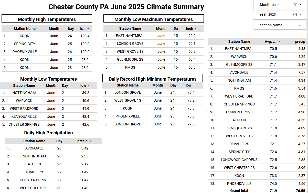
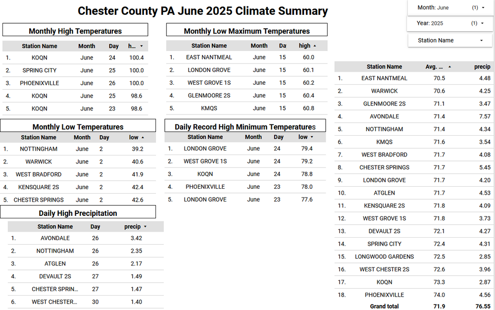
Here in June in Chester County PA finished with an average temperature across the county of 71.9 degrees. This was the 26th warmest June since records began in 1893. Of note 19 of the 25 warmest June months occurred prior to 1980. Below is the climate summary by Station for June 2025.
-

E PA/NJ/DE Summer 2025 Obs/Discussion
ChescoWx replied to Hurricane Agnes's topic in Philadelphia Region
Here in June in Chester County PA finished with an average temperature across the county of 71.9 degrees. This was the 26th warmest June since records began in 1893. Of note 19 of the 25 warmest June months occurred prior to 1980. Below is the climate summary by Station for June 2025.
-
11-12 was a prime example of certain folks using the -QBO = big high latitude (AO/NAO) blocking….cold/snowy winter broad brush. I remember many winter outlooks that went cold and snowy for the east that fall based in very large part to the -QBO, only to colossally fail
-
2025-2026 ENSO
Stormchaserchuck1 replied to 40/70 Benchmark's topic in Weather Forecasting and Discussion
Me too lol. Since returning from California in Jan 2017, the most I've seen in a year is 15", and my average is 25-30". The biggest storm was on Nov 15, 2018 at 5.5". And it didn't snow on the West coast for 5 years, so it's been a while. Not good Edit: maybe 17-18 did better than that. I don't remember. -
2025-2026 ENSO
40/70 Benchmark replied to 40/70 Benchmark's topic in Weather Forecasting and Discussion
I would take the opposite of the last 7 years.