All Activity
- Past hour
-
Hey anyone in the low 90s right now around here? Because that's what the 12z EURO said we were currently at lololol
-
So that explains why after some breaks of sun, I thought we turned the corner but the then clouds started increasing again and now it's a thick overcast again. NWS hourly forecasts still say 95F for right now. 15 - 20 degree bust is wild.
-
It’s too bad extreme heat doesn’t come with thunder or something..It would make things a bit more interesting at least for me
-

E PA/NJ/DE Summer 2025 Obs/Discussion
JTA66 replied to Hurricane Agnes's topic in Philadelphia Region
Hearing thunder and the winds are picking up. My phone thinks it’s 87F and is still forecasting a high of 92F for today. -
91/73 got 2 hours of outside work done, now I’m a sweaty mess. Hate any kind of weather that keeps me from doing my outdoor chores
-
Absolutely loving this cloud cover! Temp has dropped to 89 from 92 earlier. Thunder now.
-
Torch!
-
94/105, heat advisory verified
-

E PA/NJ/DE Summer 2025 Obs/Discussion
Hurricane Agnes replied to Hurricane Agnes's topic in Philadelphia Region
The rain band has backed over me and so far have 0.03" in the bucket. Dropped the temp to 76 with dp 74 but if all that clears out later today and the sun comes back out, it'll be a steam bath! But I'll take the rain for the plants ahead of this coming inferno week! -
Models still have a seabreeze tomorrow too. Tomorrow might be a quick run at the mid to upper 90s before we drop down precipitously in the afternoon.
-
90 here. The heat wave begins.
-
If it doesn't surge to 90 today it could be a tiny 3 day heatwave for most
-
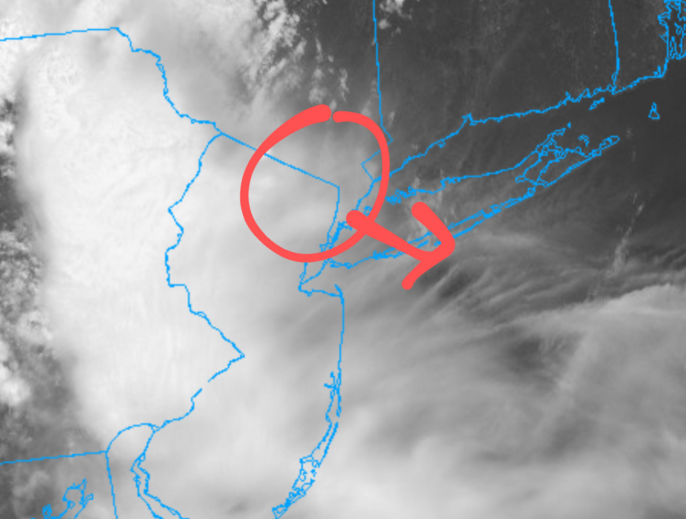
This renegade storm circled in red is producing clouds moving to the SE and is prolonging the cloud cover across the NYC area
-
Nothing had the rain this far south and west. Even at 6z they couldn't figure it out
-
1pm
-
84 presently, as cloud cover has put somewhat of a lid on temps, watching several cells to my far NW gradually moving SE Southern NJ and Delaware beach goers must be saying, where is the sun. Also, interesting are several boundaries being pushed out by various storms in Southern and eastern PA, all interacting with each other. https://www.star.nesdis.noaa.gov/GOES/sector_band.php?sat=G19§or=ne&band=GEOCOLOR&length=24
-
OKX still has not updated their AFD from 7:50am
-
Back up to 80 dew 72 with occasional brightening skies. Basically back up to the morning low before the rain
-
80/71 here with dim sun shining through the cloud deck
-
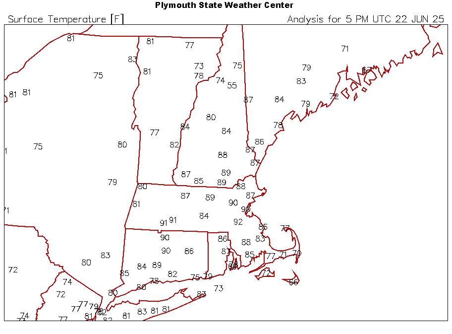
BOS was 78 at 11, 86 at Noon, looks like 90-91 will be the 1pm.
-
E PA/NJ/DE Summer 2025 Obs/Discussion
JTA66 replied to Hurricane Agnes's topic in Philadelphia Region
Picking up a light shower, temp down to 76F. Sure would be something if clouds hung around all day and I don’t make it to 80F. -
Looks like more rain late Wednesday that will put an end to this short heatwave.
-
90/75 some clouds coming in too from the weather in PA
-
81 and hazy
-
Did any models predict these mesoscale storms?


