All Activity
- Past hour
-

Central PA Fall Discussions and Obs
Voyager replied to ChescoWx's topic in Upstate New York/Pennsylvania
Hazleton must sit at the right elevation for some kind of upper level jet stream. It can be dead calm everywhere else (especially Tamaqua) but wicked windy up here in the Humboldt Industrial Park where I'm based out of. Even the early morning, when winds are usually the calmest of the day. -

Central PA Fall Discussions and Obs
Jns2183 replied to ChescoWx's topic in Upstate New York/Pennsylvania
This would have been an epic lake effect snow event if only we had the cold air. Sent from my SM-G970U1 using Tapatalk -
Central PA Fall Discussions and Obs
Jns2183 replied to ChescoWx's topic in Upstate New York/Pennsylvania
That looks like who I'm going to go with. This is going to cost me way more than my car Sent from my SM-G970U1 using Tapatalk - Today
-
Central PA Fall Discussions and Obs
Voyager replied to ChescoWx's topic in Upstate New York/Pennsylvania
This. The darkness is the worst part of winter. Of course, being a truck driver, I'm not fond of snow, either, but getting dark at 4:30pm is very depressing. -

2025 Atlantic Hurricane Season
Roger Smith replied to BarryStantonGBP's topic in Tropical Headquarters
I was thinking about 1998 and the only thing about that tropical season that I recall is Mitch at the end of the season. Now we're looking at a pretty uneventful season in general ending with Melissa which could become a high impact storm for Jamaica, eastern Cuba and or Haiti. -

Spooky Season (October Disco Thread)
WxWatcher007 replied to Prismshine Productions's topic in New England
Both ops kick Melissa with a very strong coastal low. Sub 980mb on both the GFS and Euro verbatim. -
AND THE 0Z CANADIAN is COMPLETLY DIFFERENT THEN 12Z -Impossible to start a storm thread at this point
-
Gfs now has a coastal


-

Spooky Season (October Disco Thread)
MJO812 replied to Prismshine Productions's topic in New England
The ull

-
There are still too much of a chance eastern track over western Hispanola like the ICON is showing to ignore. It wouldn't be the first time the Euro has missed a center relocation and shown a track way too far southwest. Not saying it will happen, just keep it in mind when posting 200kt Hafs A-B runs. They are going to look really bad if this turns into Cat1 Shrederolla
-
I missed on Melissa by 12 hours, but this one is exactly what I talked about in Caribbean risk. It’s a powder keg.
-
-
Spooky Season (October Disco Thread)
WxWatcher007 replied to Prismshine Productions's topic in New England
If that trough were cutting off near the Great Lakes, we’d really be in business. But that doesn’t look to be on the table. Too progressive and it gets kicked, so that makes all this a much lower likelihood from the start. -

Spooky Season (October Disco Thread)
Diggiebot replied to Prismshine Productions's topic in New England
Wayyyyy more promise than any other threat the last 5 years -

Occasional Thoughts on Climate Change
WolfStock1 replied to donsutherland1's topic in Climate Change
So - nowhere do you explain why it's a dishonest "tactic" though. Are the facts incorrect there? Given that they seem to be correct, then yes, that does mean that the climate change threat is, in fact, overstated. It proves that yes - even though the planet may be warming, it in fact has not made life more dangerous. Your case is a circular argument. You're saying that what he says isn't true because... what he says isn't true. That's not a valid argument. -

Mid to long range discussion- 2025
WinstonSalemArlington replied to wncsnow's topic in Southeastern States
-
Mid to long range discussion- 2025
WinstonSalemArlington replied to wncsnow's topic in Southeastern States
-

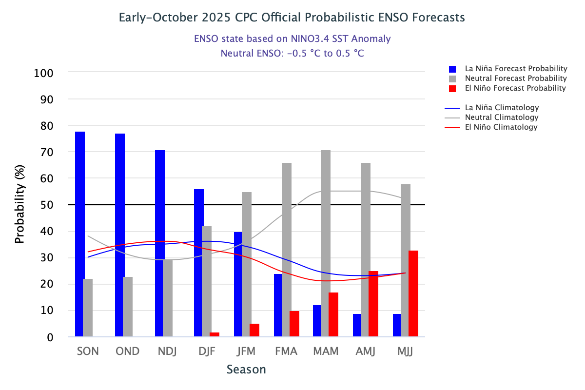
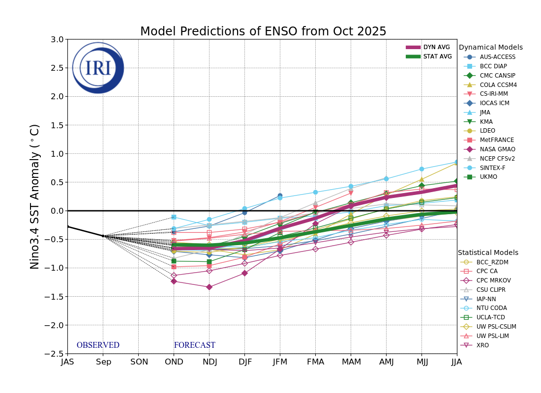
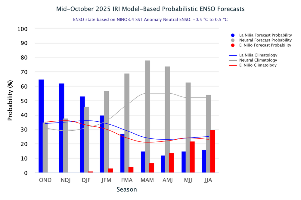
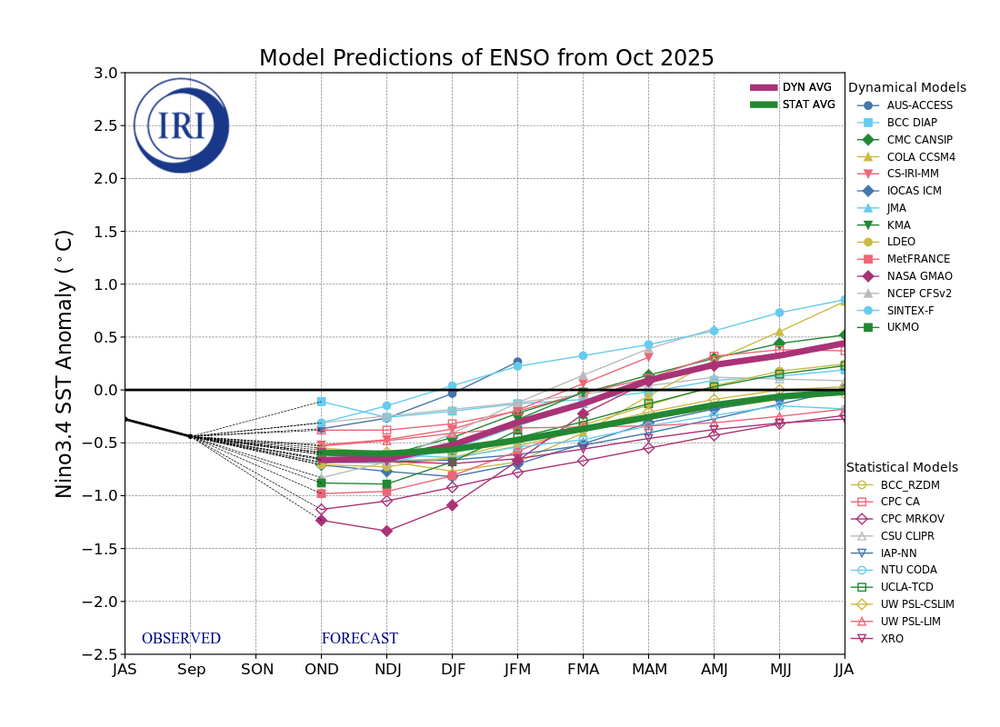
2025-2026 ENSO
PhiEaglesfan712 replied to 40/70 Benchmark's topic in Weather Forecasting and Discussion

-

2025-2026 ENSO
40/70 Benchmark replied to 40/70 Benchmark's topic in Weather Forecasting and Discussion
Take a look at July...it was much worse. Warm subsurface all beneath region 3.4. -
2025-2026 ENSO
40/70 Benchmark replied to 40/70 Benchmark's topic in Weather Forecasting and Discussion
Looking at this more, the subsurface has been beaten back in region 3.4 relative to where it was in September, but it's really a push from August....looks very similar to August. I don't think a collapse is imminent, but like I said...this does seem to validate JAMESTEC maintaining and east based event. I have been touting 2021-2022, 2017-2018 and 1995-1996 as EMI analogs since early last summer. This subsurface look is about according to plan if you ask me. -
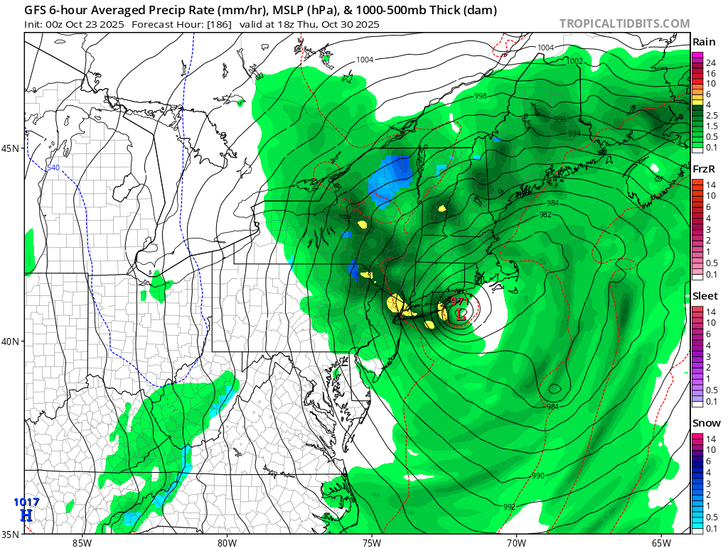
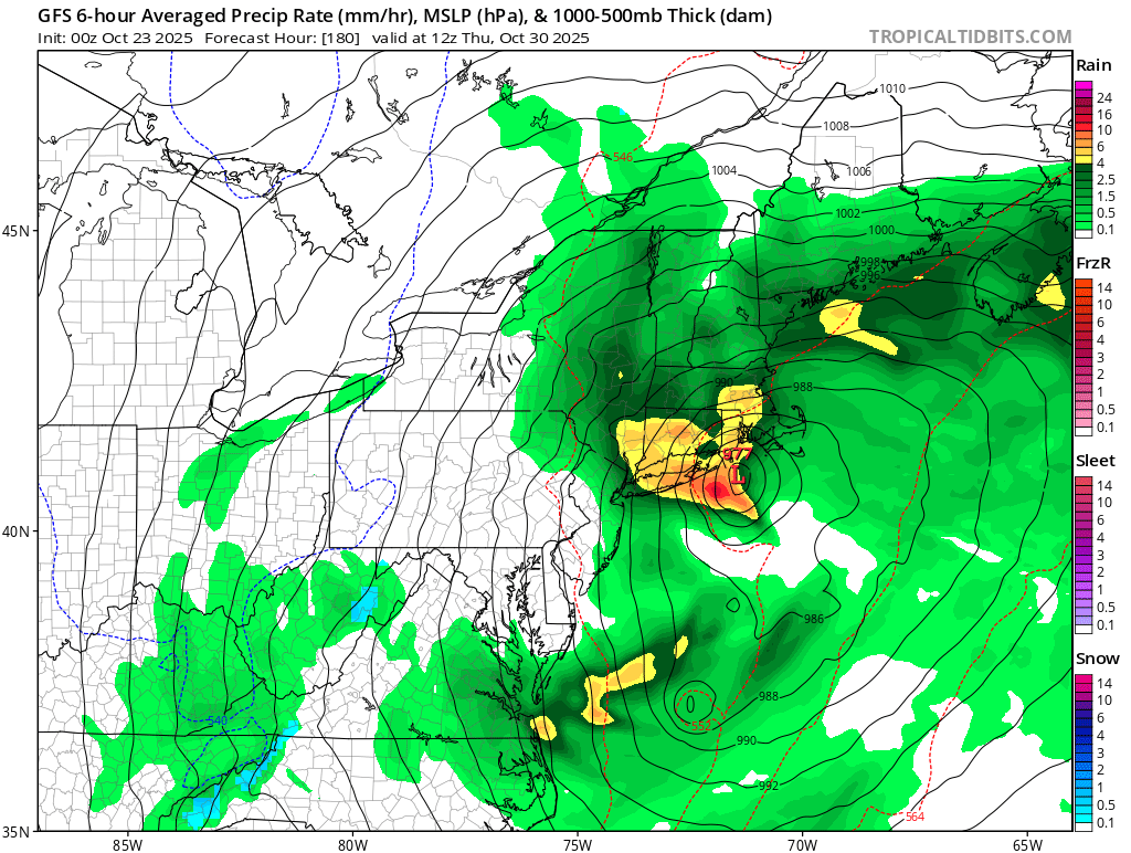
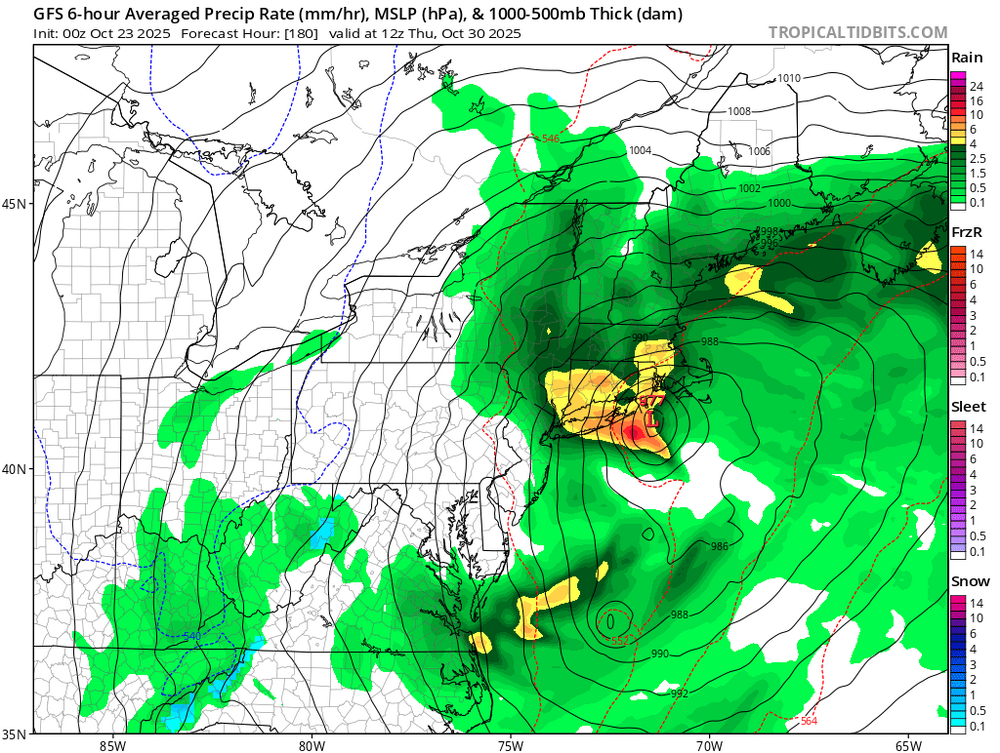
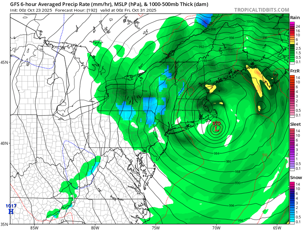
Both the 12z CMC and Euro have some iteration of this boomerang effect where a tropical system gets caught in a strong cold front, gets pulled northeast, and becomes a monster of sorts.
-

E PA/NJ/DE Autumn 2025 Obs/Discussion
Albedoman replied to PhiEaglesfan712's topic in Philadelphia Region
All I know is this scenario model run better not happen. After looking at the CMC noon run, this would make Sandy look like a baby. With all of the dead ash trees in Eastern PA now and especially in the LV and urbanized and major riverine flooding, this would be a one hell of a disaster for our area. I would see unbelievable debris dams in the waterways from these fallen limbs and trees that would wipe out major bridges in our area. The power outages would be unmanageable and you will not find a generator in stock for 250 miles from our region. The fact this scenario is already showing up for one week away warrants further discussion by all pro's. Even a slight hit would be a huge concern. There will nothing left at the NJ beaches for next year beaachgoers and NYC will get one hell of test of its new subway drainage pumping system. Definitely will keep an eye on these model runs as the media and so-called internet weather gurus on facebook/youtube will play this up real good in the next few days if the the model runs continue to show this tonight and tomorrow. Can you say Panic? -
Interestingly, long range operational models are flirting with entraining a tropical system into an eastern trough around or just after Halloween. That is not without precedent during that time of year.
-
Yes I see this new intensity forecast so I will edit the potential scoring to provide a look at possible 4 major outcomes too.
-

Central PA Fall Discussions and Obs
WmsptWx replied to ChescoWx's topic in Upstate New York/Pennsylvania
Agreed. Had my wisdom teeth removed there.